Hail Map in Mississippi on June 17, 2016
The weather event in Mississippi on June 17, 2016 includes Hail map. 20 states and 1,369 cities were impacted and suffered possible damage. The total estimated number of properties impacted is 6,211.
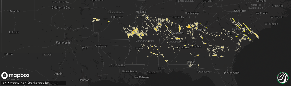
Hail
6,211
Estimated number of impacted properties by a 1.00" hail or larger0
Estimated number of impacted properties by a 1.75" hail or larger0
Estimated number of impacted properties by a 2.50" hail or largerStorm reports in Mississippi
Mississippi
| Date | Description |
|---|---|
| 06/17/20166:47 PM CDT | Trees down in the glendale community of hattiesburg |
| 06/17/20166:42 PM CDT | Trees and line down in town |
| 06/17/20166:37 PM CDT | Tree down on co rd 539 |
| 06/17/20166:30 PM CDT | Tree and power line down on leeville rd |
| 06/17/20166:25 PM CDT | Large tree was uprooted and destroyed three church cabins at shiloh church camp on the grounds of shiloh united methodist church in pelahatchie. Report and picture rela |
| 06/17/20166:25 PM CDT | Tree and power line down on co rd 515 |
| 06/17/20166:25 PM CDT | Tree down on house and vehicle on herndon rd. 5 miles west of leakesville. |
| 06/17/20166:17 PM CDT | Tree down across bell st |
| 06/17/20166:15 PM CDT | Trees and powerlines down along the 5400 block on highway 11 n. |
| 06/17/20166:10 PM CDT | Tree downed along pittman road in southwest jones county. |
| 06/17/20166:10 PM CDT | Multiple trees downed at the intersection of augusta road and ovett-moselle road. |
| 06/17/20166:05 PM CDT | Tree down on township road in ellisville. |
| 06/17/20166:05 PM CDT | Trees and powerlines down blocking sandhill church road. |
| 06/17/20166:04 PM CDT | Tree down in the 300 block of andrew chapel road. |
| 06/17/20166:00 PM CDT | Tree down on power lines at 163 ira g odum road. Downed power line set fire to a pasture. |
| 06/17/20166:00 PM CDT | Trees downed on highway 590 near ellisville causing a partial road blockage. |
| 06/17/20166:00 PM CDT | Tree was downed on spur line road causing partial road blockage. |
| 06/17/20165:55 PM CDT | A few trees down |
| 06/17/20165:55 PM CDT | A few trees down off hwy 37 |
| 06/17/20165:55 PM CDT | Trees and lines down along highway 29 n near pleasant ridge baptist church. |
| 06/17/20165:50 PM CDT | Tree down along 5th st and tree on home along 6th ave. No injuries. |
| 06/17/20165:50 PM CDT | Trees down on power lines and road partially blocked at 600 block of state street |
| 06/17/20165:50 PM CDT | Tree was downed along lower myrick road in laurel. |
| 06/17/20165:45 PM CDT | Tree downed on 7th avenue near highland church. |
| 06/17/20165:45 PM CDT | Powerlines downed in roadway on welch road off of highway 533. |
| 06/17/20165:45 PM CDT | Trees and powerlines downed at 1835 highway 184 e. |
| 06/17/20165:35 PM CDT | Trees downed at the intersection of bonner road and claiborne road. Powerlines were also downed on west main street. |
| 06/17/20165:35 PM CDT | *** 1 inj *** falling limbs caused one injury in the shady grove community in jones county. Person injured was transported to the hospital. |
| 06/17/20165:32 PM CDT | A local report indicates 1.00 inch wind near CRUGER |
| 06/17/20165:30 PM CDT | Tree downed at 162 mclin cove from outflow boundary. |
| 06/17/20165:27 PM CDT | Tree down on hwy 14 |
| 06/17/20165:13 PM CDT | Trees down along county road 290. |
| 06/17/20165:09 PM CDT | Tree down on old jackson rd |
| 06/17/20165:04 PM CDT | Trees down along county road 511. |
| 06/17/20164:47 PM CDT | Tree down along hwy 430 |
| 06/17/20164:45 PM CDT | Occurred between decatur and chunky |
| 06/17/20164:43 PM CDT | Trees down along county road 514 in the northeast part of the county. |
| 06/17/20164:31 PM CDT | 61 mph gust measured at key field asos due to outflow winds. |
| 06/17/20164:28 PM CDT | Several trees down across teh south and southeastern parts of the county. |
| 06/17/20164:23 PM CDT | Power lines down on the reservation north of hwy 16 |
| 06/17/20164:20 PM CDT | Trees down across roads around collinsville. |
| 06/17/20164:20 PM CDT | Tree down on hwy 493 in the bailey community |
| 06/17/20164:18 PM CDT | Several trees down across the n portion of the county. |
| 06/17/20164:15 PM CDT | Report of multiple trees down along the intersection of gibson road and conehatta road...highway 15 and highway 494. Likely associated with outflow boundary. |
| 06/17/20164:05 PM CDT | Trees down along hwy 14 east |
| 06/17/20163:57 PM CDT | Tree down on the natchez trace. |
| 06/17/20163:55 PM CDT | Numerous trees down across the county |
| 06/17/20163:52 PM CDT | Power line down in mccool causing several outages. |
| 06/17/20163:46 PM CDT | A couple trees down along binnsville rd |
| 06/17/20163:46 PM CDT | Tree downed on highway 614 just ne of the city due to outflow winds. |
| 06/17/20163:46 PM CDT | Reports of trees and powerlines down in the eastern side of the county along highway 16 e. |
| 06/17/20163:28 PM CDT | Few trees down around the area. |
| 06/17/20163:20 PM CDT | Reports of trees and powerlines down along highway 14 between the city limits and the winston county line. |
| 06/17/20163:10 PM CDT | Tree fell on a car on north columbus avenue near evergreen church road. No injuries reported. Several power outages are also ongoing across the city as well. |
| 06/17/20163:10 PM CDT | Tree downed damaging a picnic table. Report and picture relayed via social media. |
| 06/17/20163:10 PM CDT | Few trees down around the area. |
| 06/17/20163:10 PM CDT | Trees and large limbs downed in louisville...causing damage to a truck. Report and picture relayed via social media. |
| 06/17/20163:05 PM CDT | Report of a tree down on a house 6 miles southwest of brooksville on macon lynn creek road. |
| 06/17/20163:05 PM CDT | Numerous trees down across the western portions of the county. |
| 06/17/20163:00 PM CDT | 1 tree down near the intersection of county road 69 and county road 100. |
| 06/17/20162:50 PM CDT | Report of trees down at the intersection of 11th st and 3rd avenue and also at 5th avenue. |
| 06/17/20162:47 PM CDT | Tree down on waverly road just northwest of columbus. |
| 06/17/20162:40 PM CDT | Tree down on barnett circle a few miles northwest of columbus. |
| 06/17/20162:40 PM CDT | Tree blocking road near intersection of oktoc rd and hillbrook dr |
| 06/17/20162:30 PM CDT | Tree blocking road at intersection of hwy 389 and n maben bell schoolhouse rd. |
| 06/17/20162:30 PM CDT | Numerous trees down across the county. |
| 06/17/20162:29 PM CDT | Tree down on house near intersection of washington and jefferson st in west point. No injuries reported. |
| 06/17/20162:20 PM CDT | A few trees down in the city and also in the east end of the county. |
| 06/17/20162:10 PM CDT | Tree down across hwy 46 |
| 06/17/20162:05 PM CDT | Large pecan tree down in amory |
| 06/17/20161:52 PM CDT | Large tree down in thaxton. Time is radar estimated. |
| 06/17/20161:24 PM CDT | Two reports of quarter size and smaller hail in baldwyn. |
| 06/17/20161:20 PM CDT | Tree and powerlines down in booneville. |
| 06/17/20161:19 PM CDT | Large limbs down over power lines in thaxton. |
| 06/17/20161:15 PM CDT | Large tree down in belmont. |
| 06/17/20161:15 PM CDT | Hail nickel to quater size in pontotoc. |
| 06/17/20161:10 PM CDT | Trees and power lines down along bray and white roads north of thaxton. |
| 06/17/201612:25 PM CDT | Some trees and limbs down in baldwyn. |
| 06/16/20168:05 PM CDT | Tin roof was blown off of a building and blocking watson road near the intersection of highway 12. |
| 06/16/20167:55 PM CDT | Trees and powerlines were downed in arcola. |
| 06/16/20167:50 PM CDT | County 911 dispatch received several reports of trees and powerlines downed across ocean springs. |
| 06/16/20167:50 PM CDT | Many downed trees and powerlines in the greenville city limits...including south main street. |
| 06/16/20167:45 PM CDT | A few trees down |
| 06/16/20167:40 PM CDT | Scattered trees were blown down on the east side of the county. |
| 06/16/20167:20 PM CDT | A few trees down near purvis-columbia rd |
| 06/16/20167:18 PM CDT | A power line and tree was blown down on lee street in the city. |
| 06/16/20167:15 PM CDT | Widespread powerlines and trees blown around mainly the western part of the county. |
| 06/16/20167:10 PM CDT | A few trees down off purvis-olho rd near doc johnson rd |
| 06/16/20167:00 PM CDT | Numerous trees downed in the southern portions of the county. |
| 06/16/20167:00 PM CDT | Few trees down along knight rd |
All States Impacted by Hail Map on June 17, 2016
Cities Impacted by Hail Map on June 17, 2016
- Wakeeney, KS
- Hill City, KS
- Colton, SD
- Richmond, MN
- Cold Spring, MN
- Eastover, SC
- Gadsden, SC
- Hopkins, SC
- Columbia, SC
- Wray, CO
- Alma, GA
- Lenora, KS
- Burwell, NE
- Perham, MN
- Sidon, MS
- Cruger, MS
- Mena, AR
- Saint Francis, KS
- Shellman, GA
- Cuthbert, GA
- Coleman, GA
- Andrews, SC
- Georgetown, SC
- Elm Creek, NE
- Riverdale, NE
- Kearney, NE
- Amherst, NE
- Cimarron, KS
- Atwood, KS
- Weston, WY
- Broadus, MT
- Spencer, SD
- North Bend, NE
- Menahga, MN
- Nevis, MN
- Camden, SC
- Fulton, MS
- Hawley, MN
- Lake Park, MN
- Fosston, MN
- Cove, AR
- Watson, OK
- Smithville, OK
- Hatfield, AR
- North Platte, NE
- Hamilton, AL
- Winfield, AL
- Eldridge, AL
- Brilliant, AL
- Carbon Hill, AL
- Nauvoo, AL
- Haleyville, AL
- Bear Creek, AL
- Beaver City, NE
- Eastman, GA
- Litchfield, MN
- Paynesville, MN
- Eden Valley, MN
- Grove City, MN
- Aladdin, WY
- Hulett, WY
- Alva, WY
- Nettleton, MS
- Dawson, MN
- Madison, MN
- Ponsford, MN
- Aberdeen, MS
- Prairie, MS
- Fitzgerald, GA
- Gettysburg, SD
- Hoven, SD
- Kingsley, IA
- Pierson, IA
- Heidelberg, MS
- Vossburg, MS
- Pinewood, SC
- Wilmore, KS
- Coldwater, KS
- Saint George, SC
- Phillipsburg, KS
- Stewart, MN
- Buffalo Lake, MN
- Lake Lillian, MN
- Hector, MN
- Penokee, KS
- Morland, KS
- McDonald, KS
- Cross, SC
- Holly Hill, SC
- Prague, NE
- Newnan, GA
- Sharpsburg, GA
- Martin, SC
- Holdrege, NE
- Atlanta, NE
- Heflin, AL
- Carrollton, MS
- Sedgwick, CO
- Haxtun, CO
- Anniston, AL
- Albany, MN
- Saint Martin, MN
- Solway, MN
- Shevlin, MN
- Gonvick, MN
- Lengby, MN
- Trail, MN
- Gully, MN
- Bagley, MN
- Clearbrook, MN
- Oberlin, KS
- Warrenton, GA
- Mitchell, GA
- Eagle Bend, MN
- Bertha, MN
- Lake Village, AR
- Eudora, AR
- Lake, MS
- Forest, MS
- Waterford, MS
- Holly Springs, MS
- Heavener, OK
- Rutland, SD
- Madison, SD
- Nunda, SD
- Winfred, SD
- Montrose, SD
- Wentworth, SD
- Copeland, KS
- Grygla, MN
- Goodridge, MN
- Plummer, MN
- Broxton, GA
- Murdock, NE
- Weeping Water, NE
- Battle Lake, MN
- Big Falls, MN
- Hurley, SD
- Parker, SD
- Shaw, MS
- Indianola, MS
- Leland, MS
- Yatesville, GA
- Thomaston, GA
- Lorraine, KS
- Holyrood, KS
- Snow Lake, AR
- Ellinwood, KS
- Claflin, KS
- Sparta, GA
- Benkelman, NE
- Max, NE
- Stratton, NE
- Register, GA
- Statesboro, GA
- Metter, GA
- Osakis, MN
- Carlos, MN
- Miltona, MN
- Long Prairie, MN
- Saint Onge, SD
- Spearfish, SD
- Scribner, NE
- Fremont, NE
- Hooper, NE
- Ames, NE
- Irmo, SC
- Tuscaloosa, AL
- Chauncey, GA
- Danville, AL
- Dunning, NE
- Savannah, GA
- Draper, SD
- Union, SC
- Blair, SC
- Carlisle, SC
- Union, MS
- Oakland, AR
- Yellville, AR
- Peel, AR
- Amory, MS
- Osage, MN
- Park Rapids, MN
- Julesburg, CO
- Goose Creek, SC
- Charleston, SC
- Huger, SC
- Liberty, MS
- Ravenna, NE
- Olivia, MN
- Danube, MN
- Greeley, NE
- Rockville, NE
- Loup City, NE
- Ashton, NE
- Centre, AL
- Piedmont, AL
- Crookston, MN
- Greenbush, MN
- Strathcona, MN
- Junction City, KS
- Bruce, MS
- Banner, MS
- Ailey, GA
- Mount Vernon, GA
- Vidalia, GA
- Browerville, MN
- Cushing, MN
- Cascilla, MS
- Morrow, GA
- Conley, GA
- Ellenwood, GA
- Rex, GA
- Atlanta, GA
- Jonesboro, GA
- Stockbridge, GA
- Forest Park, GA
- Pickens, AR
- Dumas, AR
- Buchanan, GA
- Rome, GA
- Silver Creek, GA
- Cave Spring, GA
- Cedartown, GA
- Rockmart, GA
- Aragon, GA
- Lindale, GA
- Kennesaw, GA
- Marietta, GA
- Brewster, KS
- Russellville, AL
- Tuscumbia, AL
- Lexington, NE
- Cozad, NE
- Panacea, FL
- Phil Campbell, AL
- Milan, GA
- Hoxie, KS
- Selden, KS
- Colby, KS
- Grinnell, KS
- Rexford, KS
- Rienzi, MS
- Corinth, MS
- Haven, KS
- Litchfield, NE
- Boelus, NE
- Minneola, KS
- Kelliher, MN
- Houlka, MS
- Red Bay, AL
- Reevesville, SC
- Smoaks, SC
- Cottageville, SC
- Walterboro, SC
- Round O, SC
- Ruffin, SC
- Dorchester, SC
- Ridgeville, SC
- Loomis, NE
- Madison, GA
- Newborn, GA
- Detroit Lakes, MN
- Callaway, MN
- Holcomb, MS
- Greenwood, MS
- Elyria, NE
- Ord, NE
- Sebeka, MN
- Vining, MN
- Sauk Centre, MN
- Nelson, MN
- Henning, MN
- Clarissa, MN
- New York Mills, MN
- Clitherall, MN
- Bluffton, MN
- Verndale, MN
- Hewitt, MN
- Deer Creek, MN
- West Union, MN
- Villard, MN
- Parkers Prairie, MN
- Wadena, MN
- Brownell, KS
- Ellis, KS
- Brady, NE
- Aurora, SD
- Brookings, SD
- Volga, SD
- Gove, KS
- Quinter, KS
- Alzada, MT
- Tillar, AR
- Columbus, MS
- Hamilton, MS
- Caledonia, MS
- Stapleton, NE
- Meridian, MS
- Bailey, MS
- Dodge City, KS
- Byron, GA
- Fort Valley, GA
- Hutchinson, MN
- Salley, SC
- Springfield, SC
- Wagener, SC
- Aiken, SC
- Kingstree, SC
- Witten, SD
- Mutual, OK
- Mooreland, OK
- Round Lake, MN
- Bemidji, MN
- Pomaria, SC
- May, OK
- McCracken, KS
- Hays, KS
- Newton, MS
- Idalia, CO
- Sumter, SC
- Alcolu, SC
- Manning, SC
- Pretty Prairie, KS
- Rush Center, KS
- Larned, KS
- Bonifay, FL
- Smiths Station, AL
- Gordon, AL
- Marianna, FL
- Cottonwood, AL
- Lebanon, SD
- Tolstoy, SD
- Carrollton, GA
- Jacksonville, AL
- Franklin, GA
- Woodland, AL
- Fruithurst, AL
- Tallapoosa, GA
- Bowdon, GA
- Roopville, GA
- Bremen, GA
- Waco, GA
- Gadsden, AL
- Graham, AL
- Warner Robins, GA
- Maywood, NE
- Altha, FL
- Brooks, MN
- Clinton, SC
- Bowman, SC
- St John, KS
- Itta Bena, MS
- Wauneta, NE
- Ruleville, MS
- Merigold, MS
- Mound Bayou, MS
- Drew, MS
- Danbury, NE
- Culbertson, NE
- McCook, NE
- Indianola, NE
- Inman, KS
- Sturgis, SD
- Rothsay, MN
- Presho, SD
- Vivian, SD
- Nashua, MN
- Campbell, MN
- Ogallah, KS
- Uriah, AL
- Little River, AL
- Bucklin, KS
- Hawkinsville, GA
- Smithville, MS
- Hosford, FL
- Bogue, KS
- Edison, NE
- Norton, KS
- Hendley, NE
- Arapahoe, NE
- Maynard, MN
- Murdock, MN
- Montevideo, MN
- Benson, MN
- Ponca, NE
- Waterbury, NE
- Emerson, NE
- Allen, NE
- Collins, MS
- Shorterville, AL
- Abbeville, AL
- Atmore, AL
- Belle Fourche, SD
- Beulah, WY
- Whitewood, SD
- Sundance, WY
- Louisville, GA
- Water Valley, MS
- Moncks Corner, SC
- Summerville, SC
- Wanda, MN
- Lamberton, MN
- Sanborn, MN
- Redwood Falls, MN
- Wabasso, MN
- Maxwell, NE
- Belview, MN
- Duncanville, AL
- Ranburne, AL
- Inwood, IA
- Larchwood, IA
- Kulm, ND
- Ashley, ND
- Edgeley, ND
- Smithfield, NE
- Bertrand, NE
- Funk, NE
- Norcatur, KS
- Waynoka, OK
- Greenville, MS
- Lower Brule, SD
- Moorcroft, WY
- Devils Tower, WY
- Gillette, WY
- Rozet, WY
- Edson, KS
- Lexington, MS
- Vaiden, MS
- Coila, MS
- Belzoni, MS
- Moorhead, MS
- Winona, MS
- Tchula, MS
- West, MS
- White, SD
- Ivanhoe, MN
- Canby, MN
- Hendricks, MN
- Granite Falls, MN
- Town Creek, AL
- Moulton, AL
- Olar, SC
- Denmark, SC
- Plains, KS
- Fowler, KS
- Meade, KS
- Thomasville, AL
- Coffeeville, AL
- Silas, AL
- Jackson, AL
- Springfield, SD
- Avon, SD
- Cass Lake, MN
- Ewing, NE
- Soperton, GA
- Hardeeville, SC
- Orrville, AL
- Atwater, MN
- Selfridge, ND
- Niobrara, NE
- Tyndall, SD
- Bellvue, CO
- Port Wentworth, GA
- Loveland, CO
- Cambridge, NE
- Bartley, NE
- Saint Stephen, SC
- Pineville, SC
- Buffalo, WY
- Kaycee, WY
- Ashland, KS
- Protection, KS
- Hot Springs National Park, AR
- Malvern, AR
- Erhard, MN
- Fergus Falls, MN
- Boyle, MS
- Cleveland, MS
- Philadelphia, MS
- Carthage, MS
- Astoria, SD
- Kingman, KS
- Murdock, KS
- Great Bend, KS
- Tea, SD
- Chancellor, SD
- Lennox, SD
- Ensign, KS
- Champion, NE
- Melrose, MN
- Victoria, KS
- Potts Camp, MS
- Addison, AL
- Vinemont, AL
- Parks, NE
- Moscow, KS
- Crawfordville, FL
- Spruce Pine, AL
- Porter, MN
- Lesterville, SD
- Bison, KS
- La Crosse, KS
- Ideal, SD
- Winner, SD
- Rock Valley, IA
- Sioux Center, IA
- Hawarden, IA
- Ireton, IA
- Venango, NE
- Amherst, CO
- Grant, NE
- Madrid, NE
- Chapin, SC
- Lowndesboro, AL
- Starkville, MS
- Menno, SD
- Olivet, SD
- Frazee, MN
- Prairie View, KS
- Mcdonough, GA
- Jackson, GA
- Covington, GA
- Sterrett, AL
- Carriere, MS
- Elwood, NE
- Comstock, NE
- Ericson, NE
- Scotia, NE
- Taylor, NE
- Helena, AL
- Montevallo, AL
- Alabaster, AL
- Bessemer, AL
- Jessie, ND
- Cooperstown, ND
- Odenville, AL
- Oneonta, AL
- Springville, AL
- Hartford, AL
- Sylacauga, AL
- Goodwater, AL
- Weogufka, AL
- Burbank, SD
- Wedgefield, SC
- Midville, GA
- Millen, GA
- Hudson, SD
- Rockford, AL
- Stratton, CO
- Lebanon, NE
- Wilsonville, NE
- Herndon, KS
- Ludell, KS
- Trenton, NE
- Casper, WY
- Dunbar, NE
- Otoe, NE
- Wellfleet, NE
- Flandreau, SD
- Levant, KS
- Monument, KS
- Brewster, NE
- Twin Valley, MN
- Brandon, MS
- Alpharetta, GA
- Eagle Butte, SD
- Schuyler, NE
- Freeport, MN
- Red Oak, OK
- Oakley, KS
- Clarksville, FL
- Youngstown, FL
- Summerton, SC
- Stewart, MS
- French Camp, MS
- Kilmichael, MS
- Vienna, GA
- Vina, AL
- Ransom, KS
- Staples, MN
- Aldrich, MN
- Dalzell, SC
- Mayesville, SC
- Greenwood Springs, MS
- Canistota, SD
- Humboldt, SD
- Crary, ND
- Lakota, ND
- Richville, MN
- Belgrade, MN
- Dent, MN
- Echo, MN
- Lucan, MN
- Vesta, MN
- Schlater, MS
- Sunflower, MS
- Doddsville, MS
- Otter, MT
- Underwood, MN
- Palisade, NE
- Hayes Center, NE
- Taylorsville, GA
- Cartersville, GA
- Clements, MN
- Morton, MN
- Sleepy Eye, MN
- Morgan, MN
- Leighton, AL
- Mount Hope, AL
- Adger, AL
- Brookwood, AL
- Scott City, KS
- Ford, KS
- Newcastle, NE
- Gorham, KS
- Russell, KS
- Bay Minette, AL
- West Blocton, AL
- McCalla, AL
- Hull, IA
- Doon, IA
- Arco, MN
- Taunton, MN
- Minneota, MN
- Bassett, NE
- Gregory, SD
- Herrick, SD
- Springview, NE
- Dallas, SD
- Mills, NE
- Burke, SD
- Bird Island, MN
- Blomkest, MN
- Mizpah, MN
- Dublin, GA
- Dexter, GA
- Rentz, GA
- Watkins, MN
- New London, MN
- Spicer, MN
- Darwin, MN
- Jennings, KS
- Dresden, KS
- Clayton, KS
- Braithwaite, LA
- Cullman, AL
- Holbrook, NE
- Eustis, NE
- Springfield, MN
- Lodge, SC
- Islandton, SC
- Hayden, AL
- Montpelier, ND
- Opelika, AL
- Salem, AL
- Chester, OK
- Raymond, MN
- Kerkhoven, MN
- Dighton, KS
- Utica, KS
- Harleyville, SC
- Shuqualak, MS
- Tupelo, MS
- Verona, MS
- Jacksboro, TX
- Sharon, ND
- Woodstock, AL
- Waubun, MN
- Berry, AL
- Satanta, KS
- Broken Bow, NE
- Sargent, NE
- Ottertail, MN
- Hoisington, KS
- Mullinville, KS
- Uniontown, AL
- Pelahatchie, MS
- Alexandria, MN
- Glenwood, MN
- Park, KS
- Rebecca, GA
- Ellendale, ND
- Elgin, SC
- Lugoff, SC
- Stafford, KS
- New Ulm, MN
- Taloga, OK
- Vici, OK
- Seiling, OK
- Eupora, MS
- Gore Springs, MS
- Grenada, MS
- Duck Hill, MS
- Lincolnton, GA
- Crystal Springs, MS
- Florence, MS
- Otis, KS
- Pawnee Rock, KS
- Belpre, KS
- Lincoln, AL
- Roberta, GA
- Greeleyville, SC
- Salters, SC
- New Zion, SC
- Booneville, MS
- Windom, MN
- Lake City, SC
- Blue Mountain, MS
- Bethel, OK
- Broken Bow, OK
- Culloden, GA
- Imperial, NE
- Cochran, GA
- Graniteville, SC
- North Augusta, SC
- Overton, NE
- Tenstrike, MN
- Isle Of Palms, SC
- Awendaw, SC
- Mount Pleasant, SC
- Vergas, MN
- Pelican Rapids, MN
- Emery, SD
- Alexandria, SD
- Bridgewater, SD
- Marietta, MS
- New Site, MS
- Ridgeland, SC
- Yemassee, SC
- Selma, AL
- Marion Junction, AL
- Big Creek, MS
- Dothan, AL
- Tunica, MS
- Quincy, FL
- Tallahassee, FL
- Tremont, MS
- Kingston, GA
- Weston, NE
- Star City, AR
- Sumner, NE
- Miller, NE
- Odessa, NE
- Wilcox, NE
- Graceville, FL
- Waynesboro, MS
- Buckatunna, MS
- Atkinson, NE
- Pontotoc, MS
- Blountsville, AL
- Blythewood, SC
- Ridgeway, SC
- Portis, KS
- Ponemah, MN
- Utica, SD
- Banner, WY
- Story, WY
- Marion, AL
- Bay Springs, MS
- Paulding, MS
- Louin, MS
- Branchville, SC
- Barnwell, SC
- Griffin, GA
- Kandiyohi, MN
- Freedom, OK
- Fort Pierre, SD
- Slocomb, AL
- Baudette, MN
- Clearwater, NE
- Elgin, NE
- Oakdale, NE
- Chambers, NE
- Garretson, SD
- Jasper, MN
- Trent, SD
- Bruce, SD
- Leonard, MN
- Reynolds, GA
- Butler, GA
- Daviston, AL
- Northwood, ND
- Clewiston, FL
- Sharon, OK
- Waynesboro, GA
- Rochert, MN
- Audubon, MN
- Hiram, GA
- Dallas, GA
- Rockledge, GA
- East Dublin, GA
- Lyons, GA
- Tarrytown, GA
- Moville, IA
- Maurice, IA
- Remsen, IA
- Correctionville, IA
- Merrill, IA
- Le Mars, IA
- Hinton, IA
- Bird City, KS
- Milledgeville, GA
- Erskine, MN
- Mcintosh, MN
- Winger, MN
- Wagner, SD
- Oakman, AL
- Northport, AL
- Ness City, KS
- Villa Rica, GA
- Temple, GA
- Eatonton, GA
- Tallassee, AL
- Eclectic, AL
- Hope Hull, AL
- Stuart, NE
- Monticello, AR
- Bethune, CO
- Ohatchee, AL
- Canton, MS
- Sardis, AL
- McGehee, AR
- Lucedale, MS
- Lyons, KS
- Jeffers, MN
- Elko, GA
- Campbellton, FL
- Bancroft, NE
- McIntyre, GA
- Boyd, MN
- Colman, SD
- Elkton, SD
- Tuskegee, AL
- Union Springs, AL
- Hardaway, AL
- Shorter, AL
- Thief River Falls, MN
- Pillager, MN
- Ashland, AL
- Alexander City, AL
- Lexington, SC
- Gibbon, MN
- Saint Matthews, SC
- Kensington, KS
- Lagrange, GA
- Roanoke, AL
- Five Points, AL
- Sacred Heart, MN
- Naper, NE
- Aline, OK
- New Underwood, SD
- Roosevelt, MN
- Williams, MN
- Olive Branch, MS
- Hernando, MS
- Geddes, SD
- Fountain, FL
- New Albany, MS
- Brinson, GA
- Bainbridge, GA
- Elk Point, SD
- Wewahitchka, FL
- Axtell, NE
- Warthen, GA
- Columbiana, AL
- Calera, AL
- Jemison, AL
- Shelby, AL
- Plainville, KS
- Catharine, KS
- York, AL
- Mount Vernon, SD
- Corsica, SD
- Adairsville, GA
- Spencer, NE
- Oneill, NE
- Newbern, AL
- Ada, MN
- Haigler, NE
- Dacula, GA
- Lawrenceville, GA
- Motley, MN
- Hickory Flat, MS
- Dermott, AR
- Decatur, MS
- Cadwell, GA
- McRae Helena, GA
- New Orleans, LA
- Steens, MS
- Ulen, MN
- Mulhall, OK
- Crescent, OK
- Bluffton, SC
- Minter, AL
- Lake Andes, SD
- Olmitz, KS
- West Point, MS
- Okolona, MS
- Houston, MS
- Cope, SC
- Norway, SC
- Hillman, MN
- Milaca, MN
- Fairfax, SD
- Arley, AL
- Hazlehurst, GA
- West Green, GA
- Nicholls, GA
- Axtell, KS
- Summerfield, KS
- Redlake, MN
- Avon Park, FL
- Shubuta, MS
- Altoona, AL
- Cleveland, AL
- Albert, KS
- Salol, MN
- Ashville, AL
- Warroad, MN
- Iron City, GA
- Pequot Lakes, MN
- Pine River, MN
- Ogema, MN
- Jud, ND
- Reform, AL
- Chester, SD
- Watson, MN
- Milan, MN
- Yutan, NE
- Beattie, KS
- Clarkson, NE
- Dodge, NE
- Rogers, NE
- Howells, NE
- Linwood, NE
- Almena, KS
- Benoit, MS
- Belle Chasse, LA
- Natoma, KS
- Paradise, KS
- Hartford, SD
- Palco, KS
- Cottondale, FL
- Marion, ND
- Peru, NE
- Nebraska City, NE
- Alcester, SD
- Dell Rapids, SD
- Gable, SC
- Delta, AL
- Lineville, AL
- Parrish, AL
- Washington, GA
- Daleville, MS
- Salem, SD
- Glenwood, GA
- Clanton, AL
- Brierfield, AL
- Leigh, NE
- Partridge, KS
- Cordova, SC
- Bowdle, SD
- Como, MS
- Mahnomen, MN
- Clarks Hill, SC
- Powder Springs, GA
- Canova, SD
- Hephzibah, GA
- Fairfax, MN
- Cameron, SC
- Fosters, AL
- Ralph, AL
- Coker, AL
- Buhl, AL
- Flippin, AR
- Moody, AL
- Chalmette, LA
- Arabi, LA
- Lena, MS
- Morton, MS
- Long Island, KS
- Abbeville, GA
- Cedar Bluffs, NE
- Camden, AL
- Waskish, MN
- Michigan, ND
- Newfolden, MN
- Hitterdal, MN
- Grey Eagle, MN
- Roscoe, MN
- Barnesville, MN
- Brooks, GA
- Williamson, GA
- Zebulon, GA
- Senoia, GA
- Oxford, AL
- Munford, AL
- Courtland, MN
- Rembert, SC
- Danvers, MN
- Custer City, OK
- Lake Benton, MN
- Clayton, AL
- Fargo, OK
- Woodward, OK
- Sinai, SD
- Arlington, SD
- Clarkfield, MN
- Toronto, SD
- Abbyville, KS
- Sterling, KS
- Whitmire, SC
- Newberry, SC
- Rochelle, GA
- Mullen, NE
- Tryon, NE
- Woodland, MS
- Vardaman, MS
- Crosslake, MN
- Fifty Lakes, MN
- Malmo, NE
- Rydal, GA
- White, GA
- Douglasville, GA
- Hogansville, GA
- Tyler, AL
- Oakland, MS
- Tillatoba, MS
- Cordele, GA
- Pitts, GA
- Nisland, SD
- Millport, AL
- Dudley, GA
- Abbeville, MS
- Byhalia, MS
- Oxford, MS
- Tabor, SD
- Ashburn, GA
- Autaugaville, AL
- Bishopville, SC
- Roseau, MN
- Ellsworth, KS
- Rhine, GA
- Jacksonville, GA
- Wray, GA
- Bloomington, NE
- Greensboro, GA
- Rohwer, AR
- Shelby, MS
- Inverness, MS
- Gunnison, MS
- Minter City, MS
- McCarley, MS
- Charleston, MS
- Durant, MS
- Parchman, MS
- Watson, AR
- Hollandale, MS
- North Carrollton, MS
- Tutwiler, MS
- Beulah, MS
- Ethel, MS
- Pickens, MS
- Orangeburg, SC
- Rosston, OK
- Englewood, KS
- Canton, GA
- Woodstock, GA
- Little River, KS
- Duluth, GA
- Calhoun City, MS
- Chester, GA
- Freeman, SD
- Sublette, KS
- Monticello, GA
- Shady Dale, GA
- De Witt, NE
- Estill, SC
- Quitman, MS
- Townley, AL
- Seneca, KS
- Toxey, AL
- Needham, AL
- Hanley Falls, MN
- Gilbertown, AL
- Notasulga, AL
- Blue Springs, MS
- Laporte, MN
- Buffalo, OK
- Chunky, MS
- Little Rock, MS
- Ehrhardt, SC
- Columbus, NE
- Vale, SD
- Pineview, GA
- Glenrock, WY
- Alvord, IA
- Rock Rapids, IA
- Decatur, GA
- Lithonia, GA
- Rainbow City, AL
- Ethelsville, AL
- Curtis, NE
- Eddyville, NE
- Carrollton, AL
- Scobey, MS
- Coffeeville, MS
- Alva, OK
- Kennebec, SD
- Puposky, MN
- Thomson, GA
- Baxley, GA
- Hartington, NE
- Fordyce, NE
- Okatie, SC
- Oxford, NE
- Blackduck, MN
- Myrtle, MS
- Crane Hill, AL
- Dalton, MN
- Nickerson, KS
- Brewton, AL
- Evergreen, AL
- Dupree, SD
- Lantry, SD
- Mooreville, MS
- Halsey, NE
- Oklee, MN
- Gordo, AL
- Elrod, AL
- Double Springs, AL
- Cades, SC
- Gallant, AL
- Cosmos, MN
- Northome, MN
- Brandon, MN
- Evansville, MN
- Dassel, MN
- Willmar, MN
- Brooten, MN
- Swanville, MN
- Agra, KS
- Attalla, AL
- Jenkinsburg, GA
- Locust Grove, GA
- Anselmo, NE
- Montezuma, KS
- Geneseo, KS
- Osborne, KS
- Orange City, IA
- Hospers, IA
- Detroit, AL
- Golden, MS
- Mantachie, MS
- Grady, AR
- Denton, NE
- Yuma, CO
- Waterloo, NE
- Beltrami, MN
- Greensboro, AL
- Macksville, KS
- Gaylord, KS
- Unadilla, GA
- Andale, KS
- Mount Hope, KS
- Peachtree City, GA
- Burtrum, MN
- Jetmore, KS
- Nickerson, NE
- Plantersville, MS
- Fayette, AL
- Girard, GA
- Sylvania, GA
- Tichnor, AR
- Lane, SC
- Quinton, AL
- Seminary, MS
- Ellisville, MS
- Wedowee, AL
- Kirwin, KS
- Bristol, FL
- Hickman, NE
- Roca, NE
- Pittsboro, MS
- Early Branch, SC
- Coosawhatchie, SC
- Varnville, SC
- Claxton, GA
- Eutaw, AL
- Emmet, NE
- Amelia, NE
- Sumner, MS
- Waverly, AL
- Horton, AL
- Holly Pond, AL
- Trussville, AL
- Remlap, AL
- Alexander, KS
- Ripley, MS
- Cedar Bluff, AL
- Chattahoochee, FL
- Hudson, KS
- Terry, MS
- Winona, KS
- Dumas, MS
- Baldwyn, MS
- Guntown, MS
- Alford, FL
- Callaway, NE
- Auburn, AL
- Byromville, GA
- Pinehurst, GA
- Moore Haven, FL
- Wilmar, AR
- Belden, MS
- Laverne, OK
- Fort Gaines, GA
- Pender, NE
- Thurston, NE
- Neeses, SC
- Colon, NE
- Eutawville, SC
- Labelle, FL
- Adrian, GA
- Montezuma, GA
- Grayson, GA
- Loganville, GA
- Valley, NE
- Batesburg, SC
- Pennock, MN
- Alamo, GA
- Midland, GA
- Athol, KS
- Miami, FL
- Platte, SD
- Ethan, SD
- Fort Supply, OK
- Arnett, OK
- Oden, AR
- Mount Ida, AR
- Randolph, MS
- Leedey, OK
- Sharon, KS
- Etta, MS
- Thaxton, MS
- Seaforth, MN
- Bonesteel, SD
- Scotland, SD
- Elsie, NE
- Columbus, GA
- Appling, GA
- Modoc, SC
- Mitchell, SD
- Hackleburg, AL
- Soso, MS
- Taylorsville, MS
- Nesbit, MS
- Crawfordville, GA
- Pawnee City, NE
- Burchard, NE
- Parkston, SD
- Enterprise, MS
- Pine Apple, AL
- Wetumpka, AL
- Chipley, FL
- Kathleen, GA
- Perry, GA
- Vance, MS
- Lambert, MS
- Saltillo, MS
- Manhattan, KS
- Gothenburg, NE
- Bankston, AL
- Saint Marks, FL
- Cottondale, AL
- Newton, AL
- Moundville, AL
- Holyoke, CO
- Hutchinson, KS
- Gould, AR
- Letohatchee, AL
- Anthon, IA
- Valparaiso, NE
- Ceresco, NE
- Morse Bluff, NE
- Bamberg, SC
- Steen, MN
- McDavid, FL
- Philipp, MS
- Bejou, MN
- Centreville, AL
- Tyrone, GA
- Red Banks, MS
- Akeley, MN
- Telogia, FL
- Cassatt, SC
- Lynchburg, SC
- Arabi, GA
- Oconto, NE
- Franklin, MN
- Hanska, MN
- Hickory, MS
- Benton, AR
- Satsuma, AL
- Saraland, AL
- Belmont, MS
- Cherokee, AL
- Dennis, MS
- Tishomingo, MS
- Iuka, MS
- Hodges, AL
- Black, AL
- West Point, NE
- Arnold, NE
- Augusta, GA
- Appleton, MN
- Tipton, KS
- Tallulah, LA
- Collyer, KS
- Fertile, MN
- Pleasanton, NE
- Camp Hill, AL
- Vance, SC
- Santee, SC
- Bonaire, GA
- Dry Branch, GA
- Safford, AL
- Thomaston, AL
- Jenkinsville, SC
- Winnsboro, SC
- Arlington, NE
- Rozel, KS
- Beaufort, SC
- Logan, KS
- Boyes, MT
- Winthrop, MN
- Trenton, TN
- Blountstown, FL
- Swainsboro, GA
- Clara City, MN
- Lafayette, AL
- Harlem, GA
- Grovetown, GA
- Wahoo, NE
- Lake George, MN
- Norwood, GA
- Gackle, ND
- Falkville, AL
- Howard, SD
- Sulligent, AL
- Wilson, KS
- Brownton, MN
- Montrose, AR
- Fayetteville, GA
- Concord, GA
- Dyersburg, TN
- Grainfield, KS
- Hubbard, NE
- Wakefield, NE
- Jackson, NE
- Republican City, NE
- Naponee, NE
- Pooler, GA
- Hanahan, SC
- Panama City, FL
- Neche, ND
- Marietta, MN
- Drake, CO


