Hail Map in South Carolina on June 17, 2016
The weather event in South Carolina on June 17, 2016 includes Hail map. 20 states and 1,369 cities were impacted and suffered possible damage. The total estimated number of properties impacted is 0.
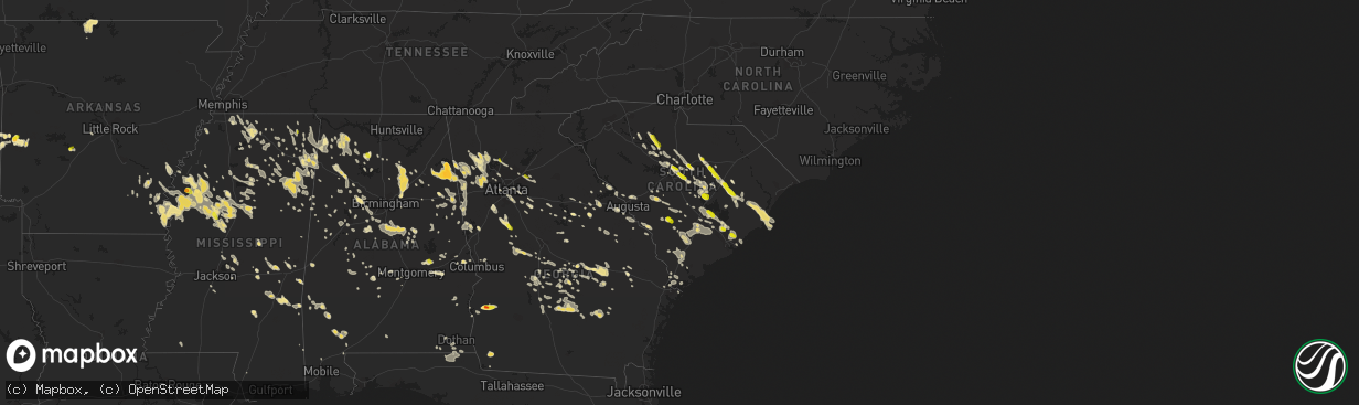
Hail
0
Estimated number of impacted properties by a 1.00" hail or larger0
Estimated number of impacted properties by a 1.75" hail or larger0
Estimated number of impacted properties by a 2.50" hail or largerStorm reports in South Carolina
South Carolina
| Date | Description |
|---|---|
| 06/17/20164:48 PM CDT | Reports of at least 9 trees down across the southern portion of hilton head island...including some across powerlines. Additionally... Structure damage occurred in the |
| 06/17/20164:47 PM CDT | Sc state hwy patrol reports tree down across the road at the intersection of s okatie hwy and us 17. Time estiamted from radar |
| 06/17/20164:46 PM CDT | *** 2 inj *** 2 injured when a large tree fell on them in the 40 block of jenkins rd. Time estimated based on radar. |
| 06/17/20164:41 PM CDT | Reports of at least 12 trees down across northern portions of hilton head island...some across powerlines. Includes a tree down on a vehicle near the intersection of wi |
| 06/17/20164:41 PM CDT | Numerous trees reported down around bluffton. |
| 06/17/20164:36 PM CDT | Multiple large trees down along business 278 in the northern portion of hilton head island |
| 06/17/20164:35 PM CDT | A local report indicates 67 MPH wind near BEAUFORT COUNTY AIRPORT |
| 06/17/20164:31 PM CDT | Tree through roof of port royal elementary school. Trees also fell onto residences on ribaut rd and ridenour pl in port royal. Time estimated based on radar. |
| 06/17/20164:31 PM CDT | Tree in house. Time estimated based on radar. |
| 06/17/20164:27 PM CDT | Trees down throughout the city of beaufort. Severeal trees down on houses on tekoa ln and on cars on center dr east...ribaut rd...boundary st...and n hermitage. |
| 06/17/20164:27 PM CDT | Trees down on lemon island. Time estimated based on radar. |
| 06/17/20164:27 PM CDT | Tree down on residence along old jericho road near us 21. |
| 06/17/20164:22 PM CDT | Beaufort county em reports trees down on houses in the 600 block of sams point rd...20 block of sangster rd...and tucker ave on ladys island |
| 06/17/20164:22 PM CDT | Spotter reports two trees down at old jericho rd and hwy 21 |
| 06/17/20164:22 PM CDT | Spotter reported wind gust of 58 mph near the north end of the beaufort mcas |
| 06/17/20164:17 PM CDT | Retired nws employee estimated winds 60-65 mph with a few gusts near 70 mph. |
| 06/17/20164:17 PM CDT | Retired nws employee reported trees down. |
| 06/17/20164:15 PM CDT | Ace basin raws |
| 06/17/20164:15 PM CDT | Spotter reported estimated 60 to 70 mile per hour winds and two brief waterspouts seen from the broad river bridge in beaufort county |
| 06/17/20164:13 PM CDT | Sc state hwy patrol reports tree down at the intersection of wood duck st and sisters ferry rd. Time estimated from radar |
| 06/17/20164:13 PM CDT | Tree in house. Time estimated based on radar. |
| 06/17/20164:10 PM CDT | Trees down throughout edisto island. |
| 06/17/20164:06 PM CDT | Charleston county sheriff office reports a tree down and blocking road at intersection of smoak road and ethel post office road. |
| 06/17/20163:58 PM CDT | Sc state hwy patrol reports a tree down in the roadway at the corner of us 278 and morgandollar rd. Time estimated from radar |
| 06/17/20163:58 PM CDT | Sc state hwy patrol reports tree down on sc 174 near russell creek rd. Time estiamted from radar |
| 06/17/20163:51 PM CDT | Tree down on kent road |
| 06/17/20163:51 PM CDT | Charleston county sheriff office reports a tree down and blocking roseville road. |
| 06/17/20163:50 PM CDT | Ethel post office road closed near smoak road due to tree over road. |
| 06/17/20163:49 PM CDT | Sc state hwy patrol reports a tree down in the 2800 block of roseville rd near bumblebee rd. Time estiamted from radar |
| 06/17/20163:44 PM CDT | Sc state hwy patrol reports a tree down in the 7600 block of yemassee hwy. Time estimated from radar |
| 06/17/20163:44 PM CDT | Sc state hwy patrol reports a tree in the roadway near the intersection of cat branch rd and pine branch dr |
| 06/17/20163:44 PM CDT | Tree down on gapway road near ethridge rd |
| 06/17/20163:35 PM CDT | Large trees blown down onto two cars in hampton park. |
| 06/17/20163:33 PM CDT | Charleston county sheriff office reports a tree down at the intersection of highway 165 and ballpark road. |
| 06/17/20163:30 PM CDT | Sc state hwy patrol reports a tree down on pocotaligo rd near the holly st ext intersection. Time estimated from radar |
| 06/17/20163:30 PM CDT | Sc state hwy patrol reports a tree down on hickory hill rd near two sisters ferry rd. Time estimated from radar |
| 06/17/20163:27 PM CDT | Nws employee reports numerous large pine trees down at residence |
| 06/17/20163:25 PM CDT | Sc state highway patrol reports tree down in roadway on sc 64 near rodeo dr. Time estiamted from radar |
| 06/17/20163:20 PM CDT | Trees blown down over west ashley greenway near parkdale drive. Report received via twitter. |
| 06/17/20163:20 PM CDT | Several reports of trees down in the isle of palms and wild dunes area. Report received via twitter. |
| 06/17/20163:16 PM CDT | Trees down at charleston national golf club. Report via twitter. |
| 06/17/20163:14 PM CDT | Nws employee reports large tree down near the traffic circle at the entrance to park west subdivision |
| 06/17/20163:11 PM CDT | Trees blown down and snapped at northwoods mall. Report via twitter. |
| 06/17/20163:10 PM CDT | Tree down on montford road near pennyroyal road |
| 06/17/20163:06 PM CDT | Sc state hwy patrol reports tree down on burlington rd near the intersection of pleasant grove rd. Time estimated from radar |
| 06/17/20163:06 PM CDT | Sc state hwy patrol reports a tree down in the roadway near the intersection of burlington rd and creekbed ln. Time estimated from radar |
| 06/17/20163:02 PM CDT | Sc state highway patrol reports tree down in roadway at the intersection of halhway creek rd and sc 41. Time estiamted from radar |
| 06/17/20163:01 PM CDT | Tree down on powell road near bertie avenue |
| 06/17/20163:00 PM CDT | 1 inch hail in the town of govan. Report received through social media. Time of event estimated by radar. |
| 06/17/20163:00 PM CDT | Tree down on downing loop road at gapway road |
| 06/17/20162:57 PM CDT | Large tree blown down and blocking hickory street near w. Luke street. Report received via twitter. |
| 06/17/20162:56 PM CDT | Tree down on walker road near columbus road |
| 06/17/20162:55 PM CDT | Trees down on orange grove rd. |
| 06/17/20162:52 PM CDT | Allendale co warning point reports trees down on augusta hwy near washout rd...hwy 3 near beldock...and a large tree limb down at bay st e and memorial ave |
| 06/17/20162:51 PM CDT | Tree down on kent road |
| 06/17/20162:47 PM CDT | Large tree down at cypress gardens rd and bushy park rd |
| 06/17/20162:47 PM CDT | Sc state hwy patrol reports a tree down on augusta hwy near sidneys rd. Time estimated from radar |
| 06/17/20162:45 PM CDT | Tree down on highway 527 |
| 06/17/20162:44 PM CDT | Tree down on gapway road near ethridge rd |
| 06/17/20162:44 PM CDT | Quarter size hail reported off hwy 176 |
| 06/17/20162:38 PM CDT | Sc state hwy patrol reports a tree down near the 1500 block of dr evans rd. Time estimated from radar |
| 06/17/20162:38 PM CDT | A local report indicates 1.00 inch wind near 3 NE SANGAREE |
| 06/17/20162:37 PM CDT | Twitter report of quarter size hail in cane bay area |
| 06/17/20162:30 PM CDT | Emergency manager reports widespread tree and power line damage along highway 261 and 521 from greeleyville to andrews. Possible tornado. |
| 06/17/20162:20 PM CDT | Sc state hwy patrol reports tree down in roadway at the intersection of poplar hill dr and ruffacre ln |
| 06/17/20162:20 PM CDT | Large tree on highway 521 |
| 06/17/20162:19 PM CDT | Trees and power lines down 3047 hwy 23 west . |
| 06/17/20162:17 PM CDT | County em reports numerous trees and power lines down in the city of orangeburg. |
| 06/17/20162:15 PM CDT | Manning santee-cooper regional airport pk wnd 34018g51kt. |
| 06/17/20162:08 PM CDT | Sc state hwy patrol reports trees down along sc 311 near the intersections of old community rd and mudville rd |
| 06/17/20162:07 PM CDT | Trees down city of aiken on vaucluse rd. |
| 06/17/20162:07 PM CDT | Multiple trees and power lines down. Reported by aiken county em. |
| 06/17/20161:59 PM CDT | Report via social media of numerous trees down in beech island. |
| 06/17/20161:54 PM CDT | Tree on home along greenwood ave in ninety six. |
| 06/17/20161:48 PM CDT | Trees down hwy 261s into paxville. |
| 06/17/20161:46 PM CDT | Trees down on hwy 15s. |
| 06/17/20161:38 PM CDT | Trees down june burg rd. Time estmd by radar. |
| 06/17/20161:38 PM CDT | Numerous trees down wedgefield rd and cane savannah rd. |
| 06/17/20161:35 PM CDT | Coldstream subdivision in irmo. |
| 06/17/20161:15 PM CDT | Multiple trees and lines down 378 and pinewood road. |
| 06/17/20161:14 PM CDT | Via social media. 7651 garners ferry rd. |
| 06/17/20161:10 PM CDT | Trees down along oswego hwy. 2 trees reported down on home with no reported injuries. Time estmd by radar. |
| 06/17/20161:07 PM CDT | Report of half dollar sized hail near the intersection of leesburg rd and leitner rd. |
| 06/17/20161:05 PM CDT | Trees down in roadway. |
| 06/17/20161:05 PM CDT | Reported by 28 ows usaf wx fcstr. |
| 06/17/20161:00 PM CDT | . |
| 06/17/201612:45 PM CDT | Quarter sized hail reported near the intersection of leitner rd and leesburg rd. |
| 06/17/201612:45 PM CDT | . |
| 06/17/201612:35 PM CDT | Quarter size hail in irmo area. |
| 06/17/201612:35 PM CDT | Trees down near the intersection of highway 378 and shop road. |
| 06/17/201612:32 PM CDT | Rc-winds reported at dutch fork high school. |
| 06/17/201612:30 PM CDT | Trees down on lee brice road. |
| 06/17/201611:53 AM CDT | A local report indicates 1.00 inch wind near CARLISLE |
| 06/17/201611:47 AM CDT | Tree down along santuc-carlisle hwy |
All States Impacted by Hail Map on June 17, 2016
Cities Impacted by Hail Map on June 17, 2016
- Wakeeney, KS
- Hill City, KS
- Colton, SD
- Richmond, MN
- Cold Spring, MN
- Eastover, SC
- Gadsden, SC
- Hopkins, SC
- Columbia, SC
- Wray, CO
- Alma, GA
- Lenora, KS
- Burwell, NE
- Perham, MN
- Sidon, MS
- Cruger, MS
- Mena, AR
- Saint Francis, KS
- Shellman, GA
- Cuthbert, GA
- Coleman, GA
- Andrews, SC
- Georgetown, SC
- Elm Creek, NE
- Riverdale, NE
- Kearney, NE
- Amherst, NE
- Cimarron, KS
- Atwood, KS
- Weston, WY
- Broadus, MT
- Spencer, SD
- North Bend, NE
- Menahga, MN
- Nevis, MN
- Camden, SC
- Fulton, MS
- Hawley, MN
- Lake Park, MN
- Fosston, MN
- Cove, AR
- Watson, OK
- Smithville, OK
- Hatfield, AR
- North Platte, NE
- Hamilton, AL
- Winfield, AL
- Eldridge, AL
- Brilliant, AL
- Carbon Hill, AL
- Nauvoo, AL
- Haleyville, AL
- Bear Creek, AL
- Beaver City, NE
- Eastman, GA
- Litchfield, MN
- Paynesville, MN
- Eden Valley, MN
- Grove City, MN
- Aladdin, WY
- Hulett, WY
- Alva, WY
- Nettleton, MS
- Dawson, MN
- Madison, MN
- Ponsford, MN
- Aberdeen, MS
- Prairie, MS
- Fitzgerald, GA
- Gettysburg, SD
- Hoven, SD
- Kingsley, IA
- Pierson, IA
- Heidelberg, MS
- Vossburg, MS
- Pinewood, SC
- Wilmore, KS
- Coldwater, KS
- Saint George, SC
- Phillipsburg, KS
- Stewart, MN
- Buffalo Lake, MN
- Lake Lillian, MN
- Hector, MN
- Penokee, KS
- Morland, KS
- McDonald, KS
- Cross, SC
- Holly Hill, SC
- Prague, NE
- Newnan, GA
- Sharpsburg, GA
- Martin, SC
- Holdrege, NE
- Atlanta, NE
- Heflin, AL
- Carrollton, MS
- Sedgwick, CO
- Haxtun, CO
- Anniston, AL
- Albany, MN
- Saint Martin, MN
- Solway, MN
- Shevlin, MN
- Gonvick, MN
- Lengby, MN
- Trail, MN
- Gully, MN
- Bagley, MN
- Clearbrook, MN
- Oberlin, KS
- Warrenton, GA
- Mitchell, GA
- Eagle Bend, MN
- Bertha, MN
- Lake Village, AR
- Eudora, AR
- Lake, MS
- Forest, MS
- Waterford, MS
- Holly Springs, MS
- Heavener, OK
- Rutland, SD
- Madison, SD
- Nunda, SD
- Winfred, SD
- Montrose, SD
- Wentworth, SD
- Copeland, KS
- Grygla, MN
- Goodridge, MN
- Plummer, MN
- Broxton, GA
- Murdock, NE
- Weeping Water, NE
- Battle Lake, MN
- Big Falls, MN
- Hurley, SD
- Parker, SD
- Shaw, MS
- Indianola, MS
- Leland, MS
- Yatesville, GA
- Thomaston, GA
- Lorraine, KS
- Holyrood, KS
- Snow Lake, AR
- Ellinwood, KS
- Claflin, KS
- Sparta, GA
- Benkelman, NE
- Max, NE
- Stratton, NE
- Register, GA
- Statesboro, GA
- Metter, GA
- Osakis, MN
- Carlos, MN
- Miltona, MN
- Long Prairie, MN
- Saint Onge, SD
- Spearfish, SD
- Scribner, NE
- Fremont, NE
- Hooper, NE
- Ames, NE
- Irmo, SC
- Tuscaloosa, AL
- Chauncey, GA
- Danville, AL
- Dunning, NE
- Savannah, GA
- Draper, SD
- Union, SC
- Blair, SC
- Carlisle, SC
- Union, MS
- Oakland, AR
- Yellville, AR
- Peel, AR
- Amory, MS
- Osage, MN
- Park Rapids, MN
- Julesburg, CO
- Goose Creek, SC
- Charleston, SC
- Huger, SC
- Liberty, MS
- Ravenna, NE
- Olivia, MN
- Danube, MN
- Greeley, NE
- Rockville, NE
- Loup City, NE
- Ashton, NE
- Centre, AL
- Piedmont, AL
- Crookston, MN
- Greenbush, MN
- Strathcona, MN
- Junction City, KS
- Bruce, MS
- Banner, MS
- Ailey, GA
- Mount Vernon, GA
- Vidalia, GA
- Browerville, MN
- Cushing, MN
- Cascilla, MS
- Morrow, GA
- Conley, GA
- Ellenwood, GA
- Rex, GA
- Atlanta, GA
- Jonesboro, GA
- Stockbridge, GA
- Forest Park, GA
- Pickens, AR
- Dumas, AR
- Buchanan, GA
- Rome, GA
- Silver Creek, GA
- Cave Spring, GA
- Cedartown, GA
- Rockmart, GA
- Aragon, GA
- Lindale, GA
- Kennesaw, GA
- Marietta, GA
- Brewster, KS
- Russellville, AL
- Tuscumbia, AL
- Lexington, NE
- Cozad, NE
- Panacea, FL
- Phil Campbell, AL
- Milan, GA
- Hoxie, KS
- Selden, KS
- Colby, KS
- Grinnell, KS
- Rexford, KS
- Rienzi, MS
- Corinth, MS
- Haven, KS
- Litchfield, NE
- Boelus, NE
- Minneola, KS
- Kelliher, MN
- Houlka, MS
- Red Bay, AL
- Reevesville, SC
- Smoaks, SC
- Cottageville, SC
- Walterboro, SC
- Round O, SC
- Ruffin, SC
- Dorchester, SC
- Ridgeville, SC
- Loomis, NE
- Madison, GA
- Newborn, GA
- Detroit Lakes, MN
- Callaway, MN
- Holcomb, MS
- Greenwood, MS
- Elyria, NE
- Ord, NE
- Sebeka, MN
- Vining, MN
- Sauk Centre, MN
- Nelson, MN
- Henning, MN
- Clarissa, MN
- New York Mills, MN
- Clitherall, MN
- Bluffton, MN
- Verndale, MN
- Hewitt, MN
- Deer Creek, MN
- West Union, MN
- Villard, MN
- Parkers Prairie, MN
- Wadena, MN
- Brownell, KS
- Ellis, KS
- Brady, NE
- Aurora, SD
- Brookings, SD
- Volga, SD
- Gove, KS
- Quinter, KS
- Alzada, MT
- Tillar, AR
- Columbus, MS
- Hamilton, MS
- Caledonia, MS
- Stapleton, NE
- Meridian, MS
- Bailey, MS
- Dodge City, KS
- Byron, GA
- Fort Valley, GA
- Hutchinson, MN
- Salley, SC
- Springfield, SC
- Wagener, SC
- Aiken, SC
- Kingstree, SC
- Witten, SD
- Mutual, OK
- Mooreland, OK
- Round Lake, MN
- Bemidji, MN
- Pomaria, SC
- May, OK
- McCracken, KS
- Hays, KS
- Newton, MS
- Idalia, CO
- Sumter, SC
- Alcolu, SC
- Manning, SC
- Pretty Prairie, KS
- Rush Center, KS
- Larned, KS
- Bonifay, FL
- Smiths Station, AL
- Gordon, AL
- Marianna, FL
- Cottonwood, AL
- Lebanon, SD
- Tolstoy, SD
- Carrollton, GA
- Jacksonville, AL
- Franklin, GA
- Woodland, AL
- Fruithurst, AL
- Tallapoosa, GA
- Bowdon, GA
- Roopville, GA
- Bremen, GA
- Waco, GA
- Gadsden, AL
- Graham, AL
- Warner Robins, GA
- Maywood, NE
- Altha, FL
- Brooks, MN
- Clinton, SC
- Bowman, SC
- St John, KS
- Itta Bena, MS
- Wauneta, NE
- Ruleville, MS
- Merigold, MS
- Mound Bayou, MS
- Drew, MS
- Danbury, NE
- Culbertson, NE
- McCook, NE
- Indianola, NE
- Inman, KS
- Sturgis, SD
- Rothsay, MN
- Presho, SD
- Vivian, SD
- Nashua, MN
- Campbell, MN
- Ogallah, KS
- Uriah, AL
- Little River, AL
- Bucklin, KS
- Hawkinsville, GA
- Smithville, MS
- Hosford, FL
- Bogue, KS
- Edison, NE
- Norton, KS
- Hendley, NE
- Arapahoe, NE
- Maynard, MN
- Murdock, MN
- Montevideo, MN
- Benson, MN
- Ponca, NE
- Waterbury, NE
- Emerson, NE
- Allen, NE
- Collins, MS
- Shorterville, AL
- Abbeville, AL
- Atmore, AL
- Belle Fourche, SD
- Beulah, WY
- Whitewood, SD
- Sundance, WY
- Louisville, GA
- Water Valley, MS
- Moncks Corner, SC
- Summerville, SC
- Wanda, MN
- Lamberton, MN
- Sanborn, MN
- Redwood Falls, MN
- Wabasso, MN
- Maxwell, NE
- Belview, MN
- Duncanville, AL
- Ranburne, AL
- Inwood, IA
- Larchwood, IA
- Kulm, ND
- Ashley, ND
- Edgeley, ND
- Smithfield, NE
- Bertrand, NE
- Funk, NE
- Norcatur, KS
- Waynoka, OK
- Greenville, MS
- Lower Brule, SD
- Moorcroft, WY
- Devils Tower, WY
- Gillette, WY
- Rozet, WY
- Edson, KS
- Lexington, MS
- Vaiden, MS
- Coila, MS
- Belzoni, MS
- Moorhead, MS
- Winona, MS
- Tchula, MS
- West, MS
- White, SD
- Ivanhoe, MN
- Canby, MN
- Hendricks, MN
- Granite Falls, MN
- Town Creek, AL
- Moulton, AL
- Olar, SC
- Denmark, SC
- Plains, KS
- Fowler, KS
- Meade, KS
- Thomasville, AL
- Coffeeville, AL
- Silas, AL
- Jackson, AL
- Springfield, SD
- Avon, SD
- Cass Lake, MN
- Ewing, NE
- Soperton, GA
- Hardeeville, SC
- Orrville, AL
- Atwater, MN
- Selfridge, ND
- Niobrara, NE
- Tyndall, SD
- Bellvue, CO
- Port Wentworth, GA
- Loveland, CO
- Cambridge, NE
- Bartley, NE
- Saint Stephen, SC
- Pineville, SC
- Buffalo, WY
- Kaycee, WY
- Ashland, KS
- Protection, KS
- Hot Springs National Park, AR
- Malvern, AR
- Erhard, MN
- Fergus Falls, MN
- Boyle, MS
- Cleveland, MS
- Philadelphia, MS
- Carthage, MS
- Astoria, SD
- Kingman, KS
- Murdock, KS
- Great Bend, KS
- Tea, SD
- Chancellor, SD
- Lennox, SD
- Ensign, KS
- Champion, NE
- Melrose, MN
- Victoria, KS
- Potts Camp, MS
- Addison, AL
- Vinemont, AL
- Parks, NE
- Moscow, KS
- Crawfordville, FL
- Spruce Pine, AL
- Porter, MN
- Lesterville, SD
- Bison, KS
- La Crosse, KS
- Ideal, SD
- Winner, SD
- Rock Valley, IA
- Sioux Center, IA
- Hawarden, IA
- Ireton, IA
- Venango, NE
- Amherst, CO
- Grant, NE
- Madrid, NE
- Chapin, SC
- Lowndesboro, AL
- Starkville, MS
- Menno, SD
- Olivet, SD
- Frazee, MN
- Prairie View, KS
- Mcdonough, GA
- Jackson, GA
- Covington, GA
- Sterrett, AL
- Carriere, MS
- Elwood, NE
- Comstock, NE
- Ericson, NE
- Scotia, NE
- Taylor, NE
- Helena, AL
- Montevallo, AL
- Alabaster, AL
- Bessemer, AL
- Jessie, ND
- Cooperstown, ND
- Odenville, AL
- Oneonta, AL
- Springville, AL
- Hartford, AL
- Sylacauga, AL
- Goodwater, AL
- Weogufka, AL
- Burbank, SD
- Wedgefield, SC
- Midville, GA
- Millen, GA
- Hudson, SD
- Rockford, AL
- Stratton, CO
- Lebanon, NE
- Wilsonville, NE
- Herndon, KS
- Ludell, KS
- Trenton, NE
- Casper, WY
- Dunbar, NE
- Otoe, NE
- Wellfleet, NE
- Flandreau, SD
- Levant, KS
- Monument, KS
- Brewster, NE
- Twin Valley, MN
- Brandon, MS
- Alpharetta, GA
- Eagle Butte, SD
- Schuyler, NE
- Freeport, MN
- Red Oak, OK
- Oakley, KS
- Clarksville, FL
- Youngstown, FL
- Summerton, SC
- Stewart, MS
- French Camp, MS
- Kilmichael, MS
- Vienna, GA
- Vina, AL
- Ransom, KS
- Staples, MN
- Aldrich, MN
- Dalzell, SC
- Mayesville, SC
- Greenwood Springs, MS
- Canistota, SD
- Humboldt, SD
- Crary, ND
- Lakota, ND
- Richville, MN
- Belgrade, MN
- Dent, MN
- Echo, MN
- Lucan, MN
- Vesta, MN
- Schlater, MS
- Sunflower, MS
- Doddsville, MS
- Otter, MT
- Underwood, MN
- Palisade, NE
- Hayes Center, NE
- Taylorsville, GA
- Cartersville, GA
- Clements, MN
- Morton, MN
- Sleepy Eye, MN
- Morgan, MN
- Leighton, AL
- Mount Hope, AL
- Adger, AL
- Brookwood, AL
- Scott City, KS
- Ford, KS
- Newcastle, NE
- Gorham, KS
- Russell, KS
- Bay Minette, AL
- West Blocton, AL
- McCalla, AL
- Hull, IA
- Doon, IA
- Arco, MN
- Taunton, MN
- Minneota, MN
- Bassett, NE
- Gregory, SD
- Herrick, SD
- Springview, NE
- Dallas, SD
- Mills, NE
- Burke, SD
- Bird Island, MN
- Blomkest, MN
- Mizpah, MN
- Dublin, GA
- Dexter, GA
- Rentz, GA
- Watkins, MN
- New London, MN
- Spicer, MN
- Darwin, MN
- Jennings, KS
- Dresden, KS
- Clayton, KS
- Braithwaite, LA
- Cullman, AL
- Holbrook, NE
- Eustis, NE
- Springfield, MN
- Lodge, SC
- Islandton, SC
- Hayden, AL
- Montpelier, ND
- Opelika, AL
- Salem, AL
- Chester, OK
- Raymond, MN
- Kerkhoven, MN
- Dighton, KS
- Utica, KS
- Harleyville, SC
- Shuqualak, MS
- Tupelo, MS
- Verona, MS
- Jacksboro, TX
- Sharon, ND
- Woodstock, AL
- Waubun, MN
- Berry, AL
- Satanta, KS
- Broken Bow, NE
- Sargent, NE
- Ottertail, MN
- Hoisington, KS
- Mullinville, KS
- Uniontown, AL
- Pelahatchie, MS
- Alexandria, MN
- Glenwood, MN
- Park, KS
- Rebecca, GA
- Ellendale, ND
- Elgin, SC
- Lugoff, SC
- Stafford, KS
- New Ulm, MN
- Taloga, OK
- Vici, OK
- Seiling, OK
- Eupora, MS
- Gore Springs, MS
- Grenada, MS
- Duck Hill, MS
- Lincolnton, GA
- Crystal Springs, MS
- Florence, MS
- Otis, KS
- Pawnee Rock, KS
- Belpre, KS
- Lincoln, AL
- Roberta, GA
- Greeleyville, SC
- Salters, SC
- New Zion, SC
- Booneville, MS
- Windom, MN
- Lake City, SC
- Blue Mountain, MS
- Bethel, OK
- Broken Bow, OK
- Culloden, GA
- Imperial, NE
- Cochran, GA
- Graniteville, SC
- North Augusta, SC
- Overton, NE
- Tenstrike, MN
- Isle Of Palms, SC
- Awendaw, SC
- Mount Pleasant, SC
- Vergas, MN
- Pelican Rapids, MN
- Emery, SD
- Alexandria, SD
- Bridgewater, SD
- Marietta, MS
- New Site, MS
- Ridgeland, SC
- Yemassee, SC
- Selma, AL
- Marion Junction, AL
- Big Creek, MS
- Dothan, AL
- Tunica, MS
- Quincy, FL
- Tallahassee, FL
- Tremont, MS
- Kingston, GA
- Weston, NE
- Star City, AR
- Sumner, NE
- Miller, NE
- Odessa, NE
- Wilcox, NE
- Graceville, FL
- Waynesboro, MS
- Buckatunna, MS
- Atkinson, NE
- Pontotoc, MS
- Blountsville, AL
- Blythewood, SC
- Ridgeway, SC
- Portis, KS
- Ponemah, MN
- Utica, SD
- Banner, WY
- Story, WY
- Marion, AL
- Bay Springs, MS
- Paulding, MS
- Louin, MS
- Branchville, SC
- Barnwell, SC
- Griffin, GA
- Kandiyohi, MN
- Freedom, OK
- Fort Pierre, SD
- Slocomb, AL
- Baudette, MN
- Clearwater, NE
- Elgin, NE
- Oakdale, NE
- Chambers, NE
- Garretson, SD
- Jasper, MN
- Trent, SD
- Bruce, SD
- Leonard, MN
- Reynolds, GA
- Butler, GA
- Daviston, AL
- Northwood, ND
- Clewiston, FL
- Sharon, OK
- Waynesboro, GA
- Rochert, MN
- Audubon, MN
- Hiram, GA
- Dallas, GA
- Rockledge, GA
- East Dublin, GA
- Lyons, GA
- Tarrytown, GA
- Moville, IA
- Maurice, IA
- Remsen, IA
- Correctionville, IA
- Merrill, IA
- Le Mars, IA
- Hinton, IA
- Bird City, KS
- Milledgeville, GA
- Erskine, MN
- Mcintosh, MN
- Winger, MN
- Wagner, SD
- Oakman, AL
- Northport, AL
- Ness City, KS
- Villa Rica, GA
- Temple, GA
- Eatonton, GA
- Tallassee, AL
- Eclectic, AL
- Hope Hull, AL
- Stuart, NE
- Monticello, AR
- Bethune, CO
- Ohatchee, AL
- Canton, MS
- Sardis, AL
- McGehee, AR
- Lucedale, MS
- Lyons, KS
- Jeffers, MN
- Elko, GA
- Campbellton, FL
- Bancroft, NE
- McIntyre, GA
- Boyd, MN
- Colman, SD
- Elkton, SD
- Tuskegee, AL
- Union Springs, AL
- Hardaway, AL
- Shorter, AL
- Thief River Falls, MN
- Pillager, MN
- Ashland, AL
- Alexander City, AL
- Lexington, SC
- Gibbon, MN
- Saint Matthews, SC
- Kensington, KS
- Lagrange, GA
- Roanoke, AL
- Five Points, AL
- Sacred Heart, MN
- Naper, NE
- Aline, OK
- New Underwood, SD
- Roosevelt, MN
- Williams, MN
- Olive Branch, MS
- Hernando, MS
- Geddes, SD
- Fountain, FL
- New Albany, MS
- Brinson, GA
- Bainbridge, GA
- Elk Point, SD
- Wewahitchka, FL
- Axtell, NE
- Warthen, GA
- Columbiana, AL
- Calera, AL
- Jemison, AL
- Shelby, AL
- Plainville, KS
- Catharine, KS
- York, AL
- Mount Vernon, SD
- Corsica, SD
- Adairsville, GA
- Spencer, NE
- Oneill, NE
- Newbern, AL
- Ada, MN
- Haigler, NE
- Dacula, GA
- Lawrenceville, GA
- Motley, MN
- Hickory Flat, MS
- Dermott, AR
- Decatur, MS
- Cadwell, GA
- McRae Helena, GA
- New Orleans, LA
- Steens, MS
- Ulen, MN
- Mulhall, OK
- Crescent, OK
- Bluffton, SC
- Minter, AL
- Lake Andes, SD
- Olmitz, KS
- West Point, MS
- Okolona, MS
- Houston, MS
- Cope, SC
- Norway, SC
- Hillman, MN
- Milaca, MN
- Fairfax, SD
- Arley, AL
- Hazlehurst, GA
- West Green, GA
- Nicholls, GA
- Axtell, KS
- Summerfield, KS
- Redlake, MN
- Avon Park, FL
- Shubuta, MS
- Altoona, AL
- Cleveland, AL
- Albert, KS
- Salol, MN
- Ashville, AL
- Warroad, MN
- Iron City, GA
- Pequot Lakes, MN
- Pine River, MN
- Ogema, MN
- Jud, ND
- Reform, AL
- Chester, SD
- Watson, MN
- Milan, MN
- Yutan, NE
- Beattie, KS
- Clarkson, NE
- Dodge, NE
- Rogers, NE
- Howells, NE
- Linwood, NE
- Almena, KS
- Benoit, MS
- Belle Chasse, LA
- Natoma, KS
- Paradise, KS
- Hartford, SD
- Palco, KS
- Cottondale, FL
- Marion, ND
- Peru, NE
- Nebraska City, NE
- Alcester, SD
- Dell Rapids, SD
- Gable, SC
- Delta, AL
- Lineville, AL
- Parrish, AL
- Washington, GA
- Daleville, MS
- Salem, SD
- Glenwood, GA
- Clanton, AL
- Brierfield, AL
- Leigh, NE
- Partridge, KS
- Cordova, SC
- Bowdle, SD
- Como, MS
- Mahnomen, MN
- Clarks Hill, SC
- Powder Springs, GA
- Canova, SD
- Hephzibah, GA
- Fairfax, MN
- Cameron, SC
- Fosters, AL
- Ralph, AL
- Coker, AL
- Buhl, AL
- Flippin, AR
- Moody, AL
- Chalmette, LA
- Arabi, LA
- Lena, MS
- Morton, MS
- Long Island, KS
- Abbeville, GA
- Cedar Bluffs, NE
- Camden, AL
- Waskish, MN
- Michigan, ND
- Newfolden, MN
- Hitterdal, MN
- Grey Eagle, MN
- Roscoe, MN
- Barnesville, MN
- Brooks, GA
- Williamson, GA
- Zebulon, GA
- Senoia, GA
- Oxford, AL
- Munford, AL
- Courtland, MN
- Rembert, SC
- Danvers, MN
- Custer City, OK
- Lake Benton, MN
- Clayton, AL
- Fargo, OK
- Woodward, OK
- Sinai, SD
- Arlington, SD
- Clarkfield, MN
- Toronto, SD
- Abbyville, KS
- Sterling, KS
- Whitmire, SC
- Newberry, SC
- Rochelle, GA
- Mullen, NE
- Tryon, NE
- Woodland, MS
- Vardaman, MS
- Crosslake, MN
- Fifty Lakes, MN
- Malmo, NE
- Rydal, GA
- White, GA
- Douglasville, GA
- Hogansville, GA
- Tyler, AL
- Oakland, MS
- Tillatoba, MS
- Cordele, GA
- Pitts, GA
- Nisland, SD
- Millport, AL
- Dudley, GA
- Abbeville, MS
- Byhalia, MS
- Oxford, MS
- Tabor, SD
- Ashburn, GA
- Autaugaville, AL
- Bishopville, SC
- Roseau, MN
- Ellsworth, KS
- Rhine, GA
- Jacksonville, GA
- Wray, GA
- Bloomington, NE
- Greensboro, GA
- Rohwer, AR
- Shelby, MS
- Inverness, MS
- Gunnison, MS
- Minter City, MS
- McCarley, MS
- Charleston, MS
- Durant, MS
- Parchman, MS
- Watson, AR
- Hollandale, MS
- North Carrollton, MS
- Tutwiler, MS
- Beulah, MS
- Ethel, MS
- Pickens, MS
- Orangeburg, SC
- Rosston, OK
- Englewood, KS
- Canton, GA
- Woodstock, GA
- Little River, KS
- Duluth, GA
- Calhoun City, MS
- Chester, GA
- Freeman, SD
- Sublette, KS
- Monticello, GA
- Shady Dale, GA
- De Witt, NE
- Estill, SC
- Quitman, MS
- Townley, AL
- Seneca, KS
- Toxey, AL
- Needham, AL
- Hanley Falls, MN
- Gilbertown, AL
- Notasulga, AL
- Blue Springs, MS
- Laporte, MN
- Buffalo, OK
- Chunky, MS
- Little Rock, MS
- Ehrhardt, SC
- Columbus, NE
- Vale, SD
- Pineview, GA
- Glenrock, WY
- Alvord, IA
- Rock Rapids, IA
- Decatur, GA
- Lithonia, GA
- Rainbow City, AL
- Ethelsville, AL
- Curtis, NE
- Eddyville, NE
- Carrollton, AL
- Scobey, MS
- Coffeeville, MS
- Alva, OK
- Kennebec, SD
- Puposky, MN
- Thomson, GA
- Baxley, GA
- Hartington, NE
- Fordyce, NE
- Okatie, SC
- Oxford, NE
- Blackduck, MN
- Myrtle, MS
- Crane Hill, AL
- Dalton, MN
- Nickerson, KS
- Brewton, AL
- Evergreen, AL
- Dupree, SD
- Lantry, SD
- Mooreville, MS
- Halsey, NE
- Oklee, MN
- Gordo, AL
- Elrod, AL
- Double Springs, AL
- Cades, SC
- Gallant, AL
- Cosmos, MN
- Northome, MN
- Brandon, MN
- Evansville, MN
- Dassel, MN
- Willmar, MN
- Brooten, MN
- Swanville, MN
- Agra, KS
- Attalla, AL
- Jenkinsburg, GA
- Locust Grove, GA
- Anselmo, NE
- Montezuma, KS
- Geneseo, KS
- Osborne, KS
- Orange City, IA
- Hospers, IA
- Detroit, AL
- Golden, MS
- Mantachie, MS
- Grady, AR
- Denton, NE
- Yuma, CO
- Waterloo, NE
- Beltrami, MN
- Greensboro, AL
- Macksville, KS
- Gaylord, KS
- Unadilla, GA
- Andale, KS
- Mount Hope, KS
- Peachtree City, GA
- Burtrum, MN
- Jetmore, KS
- Nickerson, NE
- Plantersville, MS
- Fayette, AL
- Girard, GA
- Sylvania, GA
- Tichnor, AR
- Lane, SC
- Quinton, AL
- Seminary, MS
- Ellisville, MS
- Wedowee, AL
- Kirwin, KS
- Bristol, FL
- Hickman, NE
- Roca, NE
- Pittsboro, MS
- Early Branch, SC
- Coosawhatchie, SC
- Varnville, SC
- Claxton, GA
- Eutaw, AL
- Emmet, NE
- Amelia, NE
- Sumner, MS
- Waverly, AL
- Horton, AL
- Holly Pond, AL
- Trussville, AL
- Remlap, AL
- Alexander, KS
- Ripley, MS
- Cedar Bluff, AL
- Chattahoochee, FL
- Hudson, KS
- Terry, MS
- Winona, KS
- Dumas, MS
- Baldwyn, MS
- Guntown, MS
- Alford, FL
- Callaway, NE
- Auburn, AL
- Byromville, GA
- Pinehurst, GA
- Moore Haven, FL
- Wilmar, AR
- Belden, MS
- Laverne, OK
- Fort Gaines, GA
- Pender, NE
- Thurston, NE
- Neeses, SC
- Colon, NE
- Eutawville, SC
- Labelle, FL
- Adrian, GA
- Montezuma, GA
- Grayson, GA
- Loganville, GA
- Valley, NE
- Batesburg, SC
- Pennock, MN
- Alamo, GA
- Midland, GA
- Athol, KS
- Miami, FL
- Platte, SD
- Ethan, SD
- Fort Supply, OK
- Arnett, OK
- Oden, AR
- Mount Ida, AR
- Randolph, MS
- Leedey, OK
- Sharon, KS
- Etta, MS
- Thaxton, MS
- Seaforth, MN
- Bonesteel, SD
- Scotland, SD
- Elsie, NE
- Columbus, GA
- Appling, GA
- Modoc, SC
- Mitchell, SD
- Hackleburg, AL
- Soso, MS
- Taylorsville, MS
- Nesbit, MS
- Crawfordville, GA
- Pawnee City, NE
- Burchard, NE
- Parkston, SD
- Enterprise, MS
- Pine Apple, AL
- Wetumpka, AL
- Chipley, FL
- Kathleen, GA
- Perry, GA
- Vance, MS
- Lambert, MS
- Saltillo, MS
- Manhattan, KS
- Gothenburg, NE
- Bankston, AL
- Saint Marks, FL
- Cottondale, AL
- Newton, AL
- Moundville, AL
- Holyoke, CO
- Hutchinson, KS
- Gould, AR
- Letohatchee, AL
- Anthon, IA
- Valparaiso, NE
- Ceresco, NE
- Morse Bluff, NE
- Bamberg, SC
- Steen, MN
- McDavid, FL
- Philipp, MS
- Bejou, MN
- Centreville, AL
- Tyrone, GA
- Red Banks, MS
- Akeley, MN
- Telogia, FL
- Cassatt, SC
- Lynchburg, SC
- Arabi, GA
- Oconto, NE
- Franklin, MN
- Hanska, MN
- Hickory, MS
- Benton, AR
- Satsuma, AL
- Saraland, AL
- Belmont, MS
- Cherokee, AL
- Dennis, MS
- Tishomingo, MS
- Iuka, MS
- Hodges, AL
- Black, AL
- West Point, NE
- Arnold, NE
- Augusta, GA
- Appleton, MN
- Tipton, KS
- Tallulah, LA
- Collyer, KS
- Fertile, MN
- Pleasanton, NE
- Camp Hill, AL
- Vance, SC
- Santee, SC
- Bonaire, GA
- Dry Branch, GA
- Safford, AL
- Thomaston, AL
- Jenkinsville, SC
- Winnsboro, SC
- Arlington, NE
- Rozel, KS
- Beaufort, SC
- Logan, KS
- Boyes, MT
- Winthrop, MN
- Trenton, TN
- Blountstown, FL
- Swainsboro, GA
- Clara City, MN
- Lafayette, AL
- Harlem, GA
- Grovetown, GA
- Wahoo, NE
- Lake George, MN
- Norwood, GA
- Gackle, ND
- Falkville, AL
- Howard, SD
- Sulligent, AL
- Wilson, KS
- Brownton, MN
- Montrose, AR
- Fayetteville, GA
- Concord, GA
- Dyersburg, TN
- Grainfield, KS
- Hubbard, NE
- Wakefield, NE
- Jackson, NE
- Republican City, NE
- Naponee, NE
- Pooler, GA
- Hanahan, SC
- Panama City, FL
- Neche, ND
- Marietta, MN
- Drake, CO


