Hail Map in Alabama on June 17, 2016
The weather event in Alabama on June 17, 2016 includes Hail map. 20 states and 1,369 cities were impacted and suffered possible damage. The total estimated number of properties impacted is 1,183.
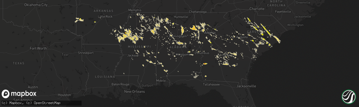
Hail
1,183
Estimated number of impacted properties by a 1.00" hail or larger0
Estimated number of impacted properties by a 1.75" hail or larger0
Estimated number of impacted properties by a 2.50" hail or largerStorm reports in Alabama
Alabama
| Date | Description |
|---|---|
| 06/17/20166:55 PM CDT | Trees down on highway 167 in coffee county |
| 06/17/20166:55 PM CDT | Trees down highway 87 just north of elba |
| 06/17/20166:50 PM CDT | Trees down countywide with a report of a tree on a house. |
| 06/17/20166:46 PM CDT | A 48 knot gust was reported by k79j asos site in andalusia. |
| 06/17/20166:46 PM CDT | A 50 knot gust was reported by k79j asos site in andalusia. |
| 06/17/20166:40 PM CDT | A 60 mph gust was recorded at usa mesonet site in atmore. |
| 06/17/20166:40 PM CDT | County 911 reports numerus trees and power lines down beginning in rabun at 640pm continuing south through 730pm in the robertsdale area. |
| 06/17/20166:40 PM CDT | An oak tree was downed across both lanes of the highway. |
| 06/17/20166:39 PM CDT | Trees and powerlines down on east jackson street in brewton... Al. Time estimated from radar. |
| 06/17/20166:35 PM CDT | Tree down in roadway on prine rd at roussert rd |
| 06/17/20166:30 PM CDT | Several reports of trees down and some blocking roadways across pike county. Some roads include county road 6618... 6622... 6647... 6643... 6605... 4404... 2242... 2204 |
| 06/17/20166:30 PM CDT | Trees and powerlines down along alabama highway 223 in pike county. Location approximate. Time estimated by radar. |
| 06/17/20166:20 PM CDT | Washington ema reports estimated 60 mph wind along hwy 43 at the mobile/washington county line. |
| 06/17/20165:51 PM CDT | Tree fell onto manufactured home. Time estimated by radar. |
| 06/17/20165:46 PM CDT | Trees down blocking road near intersection of wire road and macon county road 53. Time estimated by radar. |
| 06/17/20165:40 PM CDT | Trees down on brooksville rd. In dickenson... Al. |
| 06/17/20165:32 PM CDT | Numerous reports of trees and power lines down in grove hill... Al. |
| 06/17/20165:27 PM CDT | Tree down blocking roadway at intersection of emerald mountain expressway and rifle range road. Time estimated by radar. |
| 06/17/20165:27 PM CDT | Trees reported down by public via social media. Time estimated by radar. |
| 06/17/20165:27 PM CDT | Tree down. Public report relayed via social media. Time estimated by radar. |
| 06/17/20165:26 PM CDT | Powerlines and several trees down in the notasulga area. |
| 06/17/20165:25 PM CDT | Report of trees and power lines down on hodge rd. In coffeeville and trees down west bend north od f coffeeville. |
| 06/17/20165:20 PM CDT | Many trees down and power out in the town of butler... Al. Wind gust estimated 70 mph with the leading edge of the storms. |
| 06/17/20165:15 PM CDT | Trees down hwy 84 at blandon springs rd. |
| 06/17/20165:15 PM CDT | Approximately two dozen trees down across the city...with 8 of those down on power lines causing power outages. Time estimated. |
| 06/17/20165:13 PM CDT | Additional reports recieved of powerlines and trees down in thomasville. |
| 06/17/20165:12 PM CDT | Numerous trees and power lines down across west and central elmore county. Numerous fire departments dispatched to remove trees from roadways. One structure fire caused |
| 06/17/20165:12 PM CDT | Tree down blocking portion of u.s. Highway 29. Public report relayed via social media. Location approximate. Time estimated by radar. |
| 06/17/20165:12 PM CDT | Tree down across le bron road in the cloverdale portion of montgomery. Public report relayed via social media. Time estimated by radar. |
| 06/17/20165:09 PM CDT | Large tree down on hwy-43 south of the marengo county line. |
| 06/17/20165:08 PM CDT | Tree down partially blocking u.s. Highway 50 near camp hill baptist church. Time estimated by radar. |
| 06/17/20165:08 PM CDT | Numerous trees and power lines reported down. Time estimated by radar. |
| 06/17/20165:05 PM CDT | Trees and powerlines down along county road 63. Time estimated from radar. |
| 06/17/20165:02 PM CDT | Large tree down near highway 10 and highway 17 intersection. |
| 06/17/20164:55 PM CDT | Ksem awos reports wind gust to 51 knots. |
| 06/17/20164:53 PM CDT | Tree down blocking portions of cobbs ford road and another report of power lines down along cobbs ford road near premier place shopping center. Time estimated by radar. |
| 06/17/20164:53 PM CDT | Dime to quarter sized hail reported in tallassee. Time estimated by radar. |
| 06/17/20164:53 PM CDT | Tree down across east south street in dadeville. Time estimated by radar. |
| 06/17/20164:48 PM CDT | Tree down blocking portions of roadway near the intersection of abbett drive and rock springs road. Time estimated by radar. |
| 06/17/20164:43 PM CDT | Trees down across interstate 85 just south of valley. Time estimated by radar. |
| 06/17/20164:43 PM CDT | *** 1 inj *** a tree was blown down across the road in the 6000 block of cr 59. A motorcyclist drove into the tree. |
| 06/17/20164:15 PM CDT | Multiple trees down and power lines down on county road 25 just off of u.s. Highway 80. Time estimated by radar. |
| 06/17/20164:10 PM CDT | Multiple trees reported down across the county. Location approximate. Time estimated by radar. |
| 06/17/20164:08 PM CDT | Two trees reported down near the intersection of county road 31 and county road 49. Time estimated by radar. |
| 06/17/20164:03 PM CDT | Per law enforcement... Approx 1000 trees down across the county... Including along county road 42 between county road 44 and i-65... Which occurred around 403pm. Time e |
| 06/17/20164:00 PM CDT | Tree down across dauphin way near dauphin street in montevallo. Time estimated by radar. |
| 06/17/20164:00 PM CDT | Motor vehicle damaged by falling tree. Report via social media. Time estimated by radar. |
| 06/17/20163:55 PM CDT | Tin shop damaged. More than one building with damage at local high school. Power lines down in woodland. Power out in wedowee. Trees down across the county. Location ap |
| 06/17/20163:55 PM CDT | Several trees reported down in vincent. Time estimated by radar. |
| 06/17/20163:55 PM CDT | Two trees down near intersection of clay county road 31 and brown drive. |
| 06/17/20163:46 PM CDT | Tree fell into house. Time estimated by radar. |
| 06/17/20163:36 PM CDT | Trees and power lines down near intersection of u.s. Highway 278 and alabama highway 9. Time estimated by radar. |
| 06/17/20163:32 PM CDT | Trees down along highway 52 and at intersection of brook drive and hillsboro parkway. Time estimated by radar. |
| 06/17/20163:29 PM CDT | Trees down on homes along 48th street and 9th avenue north in birmingham. Location approximate. Time estimated by radar. |
| 06/17/20163:26 PM CDT | Several reports of trees down around helena. Time estimated by radar. |
| 06/17/20163:26 PM CDT | Wind damaged awning at a farmers market in pell city. Time estimated by radar. |
| 06/17/20163:23 PM CDT | Woodland high school lunchroom roof damaged. Time estimated by radar. |
| 06/17/20163:18 PM CDT | Multiple trees down along interstate 59 in saint clair county at mile markers 156... 158 and 159 along with at the brompton exit. Location approximate. Time estimated b |
| 06/17/20163:15 PM CDT | 2 trees down near the intersection of canterbury lane and vernon town road. Several trees down on bear creek road. Tree down on chestnut street in centreville. Location |
| 06/17/20163:12 PM CDT | Tree down near tuscaloosa city hall. Public report via social media. Time estimated by radar. |
| 06/17/20163:12 PM CDT | Several trees down along chula vista mountain road. Time estimated by radar. |
| 06/17/20163:10 PM CDT | Tree and powerlines down in coates bend community of etowah county. Time estimated by radar. |
| 06/17/20163:06 PM CDT | Trees down blocking intersection of 21st avenue south and cahaba road. Time estimated by radar. |
| 06/17/20163:06 PM CDT | Trees down on u.s. Highway 43 between tierece patton road and old fayette road. Time estimated by radar. Corrected road name. |
| 06/17/20163:01 PM CDT | 1.5-2.0 inch hail reported in spring garden along cr 10. Picture submitted via social media. |
| 06/17/20163:00 PM CDT | Tree down along 56th street in fairfield. Time estimated by radar. |
| 06/17/20162:58 PM CDT | Tree down across road with estimated wind gust to 60 mph. Time estimated by radar. |
| 06/17/20162:58 PM CDT | Tree fell onto manufactured home. Time estimated by radar. |
| 06/17/20162:58 PM CDT | Tree down in the road near the intersection of alabama highway 13 and tearce patton road. Time estimated by radar. |
| 06/17/20162:58 PM CDT | Tree down across columbiana road in homewood. Location approximate. Time estimated by radar. |
| 06/17/20162:58 PM CDT | Tree downed into power lines and house fire caused by lightning strike off of county highway 24. Time estimated by radar. |
| 06/17/20162:58 PM CDT | Tree down and power out at residence in pleasant grove. Report via social media. Time estimated by radar. |
| 06/17/20162:53 PM CDT | Tree down on roadway. Time estimated by radar. |
| 06/17/20162:53 PM CDT | Multiple trees down near alliance road location approximate. Time estimated by radar. |
| 06/17/20162:53 PM CDT | Trees down on houses in northwood lake subdivision and reports of downed power lines near union chapel road. Location approximate. Time estimated by radar. |
| 06/17/20162:48 PM CDT | Tree down in roadway. Time estimated by radar. |
| 06/17/20162:48 PM CDT | Tree and power pole fell onto and damaged a structure. Time estimated by radar. |
| 06/17/20162:43 PM CDT | Tree down in roadway. Time estimated by radar. |
| 06/17/20162:43 PM CDT | Tree down in roadway. Time estimated by radar. |
| 06/17/20162:43 PM CDT | Trees down near tip top one stop service station in the gallant community. Time estimated by radar. |
| 06/17/20162:39 PM CDT | Tree down on roadway. Time estimated by radar. |
| 06/17/20162:39 PM CDT | Power lines down across highway 79 near locust fork. Time estimated by radar. |
| 06/17/20162:25 PM CDT | Tree down on roadway. Time estimated by radar. |
| 06/17/20162:15 PM CDT | Quarter sized hail with winds in excess of 60 mph reported. Location approximate. Time estimated by radar. |
| 06/17/20162:10 PM CDT | Quarter sized hail reported on cherokee county road 34 near the intersection with cherokee county road 31. Time estimated by radar. |
| 06/17/20162:05 PM CDT | Tree down across alabama highway 6 near sipsey. Location approximate. Time estimated by radar. |
| 06/17/20162:01 PM CDT | Trees down. Possible damage to a camper near the intersection of alabama highway 31 and cherokee county 22. Time estimated by radar. |
| 06/17/20161:56 PM CDT | Nickel to golf ball sized hail reported at pine grove church on cherokee county road 22. Time estimated by radar. |
| 06/17/20161:56 PM CDT | Power line reported down near mr. Genes restaurant in sulligent. Time estimated by radar. |
| 06/17/20161:53 PM CDT | 3 trees reported down along river road in lamar county. 1 tree down along buck jackson road. Trees down off of hester lane. Location approximate. Time estimated by rada |
| 06/17/20161:53 PM CDT | Tree down on house that caused fire. Time estimated by radar. |
| 06/17/20161:42 PM CDT | Trees reported down in the detroit area. Location approximate. Time estimated by radar. |
| 06/17/20161:40 PM CDT | Six reports of trees down across the county along sr125... Cr167... Alabama hwy 44... Goddard road in haleyville... Cr60 and new hope road along with cr102 near alabama |
| 06/17/20161:37 PM CDT | Tree down on highway 19 near the alabama and mississippi state line. Location approximate. Time estimated by radar. |
| 06/17/20161:33 PM CDT | One tree was down on the railroad tracks at osborn hill road. Time estimated by radar. |
| 06/17/20161:32 PM CDT | Garage door blown off from auto shop near hackleburg. Time estimated by radar. |
| 06/17/20161:22 PM CDT | Large tree down on u.s. Highway 18 west near fayette. Time estimated by radar. |
| 06/17/20161:14 PM CDT | Quarter sized hail reported. |
| 06/17/20161:08 PM CDT | Quarter sized hail and estimated winds over 60 mph reported. Location approximate. Time estimated by radar. |
| 06/17/20161:05 PM CDT | 6 large trees were reported down along al county road 23 between red bay and vina. |
| 06/17/201612:22 PM CDT | Downed tree reported along osborn hill rd. |
| 06/16/20167:41 PM CDT | A tree reportedly fell on a car with no injuries |
| 06/16/20167:40 PM CDT | Tree down county road 68 between trawick and brannon stand road |
| 06/16/20167:35 PM CDT | Tree down on highway 231 north of dothan blocking north bound land |
| 06/16/20167:30 PM CDT | Trees down in the area |
| 06/16/20167:25 PM CDT | Spotter estimated wind gusts of 60 mph |
| 06/16/20167:15 PM CDT | Trees down in the area |
| 06/16/20167:15 PM CDT | Trees down in the area |
| 06/16/20167:15 PM CDT | Several trees down in henry county |
| 06/16/20167:08 PM CDT | Pole blown down in level plains |
| 06/16/20167:08 PM CDT | 51 knot or 59 mph gust measured at kozr |
| 06/16/20167:05 PM CDT | Trees down north of skipperville |
| 06/16/20167:05 PM CDT | Widespread trees and power lines were down in dale county as reported by the ozark-dale county e-911 facebook page |
| 06/16/20167:02 PM CDT | Trees were blown down onto power lines on county road 239. |
| 06/16/20167:00 PM CDT | Trees snapped or uprooted. |
| 06/16/20167:00 PM CDT | Numerous power lines and trees down in the ariton area. Highway 51 is blocked. Also roof off a building in the area |
All States Impacted by Hail Map on June 17, 2016
Cities Impacted by Hail Map on June 17, 2016
- Wakeeney, KS
- Hill City, KS
- Colton, SD
- Richmond, MN
- Cold Spring, MN
- Eastover, SC
- Gadsden, SC
- Hopkins, SC
- Columbia, SC
- Wray, CO
- Alma, GA
- Lenora, KS
- Burwell, NE
- Perham, MN
- Sidon, MS
- Cruger, MS
- Mena, AR
- Saint Francis, KS
- Shellman, GA
- Cuthbert, GA
- Coleman, GA
- Andrews, SC
- Georgetown, SC
- Elm Creek, NE
- Riverdale, NE
- Kearney, NE
- Amherst, NE
- Cimarron, KS
- Atwood, KS
- Weston, WY
- Broadus, MT
- Spencer, SD
- North Bend, NE
- Menahga, MN
- Nevis, MN
- Camden, SC
- Fulton, MS
- Hawley, MN
- Lake Park, MN
- Fosston, MN
- Cove, AR
- Watson, OK
- Smithville, OK
- Hatfield, AR
- North Platte, NE
- Hamilton, AL
- Winfield, AL
- Eldridge, AL
- Brilliant, AL
- Carbon Hill, AL
- Nauvoo, AL
- Haleyville, AL
- Bear Creek, AL
- Beaver City, NE
- Eastman, GA
- Litchfield, MN
- Paynesville, MN
- Eden Valley, MN
- Grove City, MN
- Aladdin, WY
- Hulett, WY
- Alva, WY
- Nettleton, MS
- Dawson, MN
- Madison, MN
- Ponsford, MN
- Aberdeen, MS
- Prairie, MS
- Fitzgerald, GA
- Gettysburg, SD
- Hoven, SD
- Kingsley, IA
- Pierson, IA
- Heidelberg, MS
- Vossburg, MS
- Pinewood, SC
- Wilmore, KS
- Coldwater, KS
- Saint George, SC
- Phillipsburg, KS
- Stewart, MN
- Buffalo Lake, MN
- Lake Lillian, MN
- Hector, MN
- Penokee, KS
- Morland, KS
- McDonald, KS
- Cross, SC
- Holly Hill, SC
- Prague, NE
- Newnan, GA
- Sharpsburg, GA
- Martin, SC
- Holdrege, NE
- Atlanta, NE
- Heflin, AL
- Carrollton, MS
- Sedgwick, CO
- Haxtun, CO
- Anniston, AL
- Albany, MN
- Saint Martin, MN
- Solway, MN
- Shevlin, MN
- Gonvick, MN
- Lengby, MN
- Trail, MN
- Gully, MN
- Bagley, MN
- Clearbrook, MN
- Oberlin, KS
- Warrenton, GA
- Mitchell, GA
- Eagle Bend, MN
- Bertha, MN
- Lake Village, AR
- Eudora, AR
- Lake, MS
- Forest, MS
- Waterford, MS
- Holly Springs, MS
- Heavener, OK
- Rutland, SD
- Madison, SD
- Nunda, SD
- Winfred, SD
- Montrose, SD
- Wentworth, SD
- Copeland, KS
- Grygla, MN
- Goodridge, MN
- Plummer, MN
- Broxton, GA
- Murdock, NE
- Weeping Water, NE
- Battle Lake, MN
- Big Falls, MN
- Hurley, SD
- Parker, SD
- Shaw, MS
- Indianola, MS
- Leland, MS
- Yatesville, GA
- Thomaston, GA
- Lorraine, KS
- Holyrood, KS
- Snow Lake, AR
- Ellinwood, KS
- Claflin, KS
- Sparta, GA
- Benkelman, NE
- Max, NE
- Stratton, NE
- Register, GA
- Statesboro, GA
- Metter, GA
- Osakis, MN
- Carlos, MN
- Miltona, MN
- Long Prairie, MN
- Saint Onge, SD
- Spearfish, SD
- Scribner, NE
- Fremont, NE
- Hooper, NE
- Ames, NE
- Irmo, SC
- Tuscaloosa, AL
- Chauncey, GA
- Danville, AL
- Dunning, NE
- Savannah, GA
- Draper, SD
- Union, SC
- Blair, SC
- Carlisle, SC
- Union, MS
- Oakland, AR
- Yellville, AR
- Peel, AR
- Amory, MS
- Osage, MN
- Park Rapids, MN
- Julesburg, CO
- Goose Creek, SC
- Charleston, SC
- Huger, SC
- Liberty, MS
- Ravenna, NE
- Olivia, MN
- Danube, MN
- Greeley, NE
- Rockville, NE
- Loup City, NE
- Ashton, NE
- Centre, AL
- Piedmont, AL
- Crookston, MN
- Greenbush, MN
- Strathcona, MN
- Junction City, KS
- Bruce, MS
- Banner, MS
- Ailey, GA
- Mount Vernon, GA
- Vidalia, GA
- Browerville, MN
- Cushing, MN
- Cascilla, MS
- Morrow, GA
- Conley, GA
- Ellenwood, GA
- Rex, GA
- Atlanta, GA
- Jonesboro, GA
- Stockbridge, GA
- Forest Park, GA
- Pickens, AR
- Dumas, AR
- Buchanan, GA
- Rome, GA
- Silver Creek, GA
- Cave Spring, GA
- Cedartown, GA
- Rockmart, GA
- Aragon, GA
- Lindale, GA
- Kennesaw, GA
- Marietta, GA
- Brewster, KS
- Russellville, AL
- Tuscumbia, AL
- Lexington, NE
- Cozad, NE
- Panacea, FL
- Phil Campbell, AL
- Milan, GA
- Hoxie, KS
- Selden, KS
- Colby, KS
- Grinnell, KS
- Rexford, KS
- Rienzi, MS
- Corinth, MS
- Haven, KS
- Litchfield, NE
- Boelus, NE
- Minneola, KS
- Kelliher, MN
- Houlka, MS
- Red Bay, AL
- Reevesville, SC
- Smoaks, SC
- Cottageville, SC
- Walterboro, SC
- Round O, SC
- Ruffin, SC
- Dorchester, SC
- Ridgeville, SC
- Loomis, NE
- Madison, GA
- Newborn, GA
- Detroit Lakes, MN
- Callaway, MN
- Holcomb, MS
- Greenwood, MS
- Elyria, NE
- Ord, NE
- Sebeka, MN
- Vining, MN
- Sauk Centre, MN
- Nelson, MN
- Henning, MN
- Clarissa, MN
- New York Mills, MN
- Clitherall, MN
- Bluffton, MN
- Verndale, MN
- Hewitt, MN
- Deer Creek, MN
- West Union, MN
- Villard, MN
- Parkers Prairie, MN
- Wadena, MN
- Brownell, KS
- Ellis, KS
- Brady, NE
- Aurora, SD
- Brookings, SD
- Volga, SD
- Gove, KS
- Quinter, KS
- Alzada, MT
- Tillar, AR
- Columbus, MS
- Hamilton, MS
- Caledonia, MS
- Stapleton, NE
- Meridian, MS
- Bailey, MS
- Dodge City, KS
- Byron, GA
- Fort Valley, GA
- Hutchinson, MN
- Salley, SC
- Springfield, SC
- Wagener, SC
- Aiken, SC
- Kingstree, SC
- Witten, SD
- Mutual, OK
- Mooreland, OK
- Round Lake, MN
- Bemidji, MN
- Pomaria, SC
- May, OK
- McCracken, KS
- Hays, KS
- Newton, MS
- Idalia, CO
- Sumter, SC
- Alcolu, SC
- Manning, SC
- Pretty Prairie, KS
- Rush Center, KS
- Larned, KS
- Bonifay, FL
- Smiths Station, AL
- Gordon, AL
- Marianna, FL
- Cottonwood, AL
- Lebanon, SD
- Tolstoy, SD
- Carrollton, GA
- Jacksonville, AL
- Franklin, GA
- Woodland, AL
- Fruithurst, AL
- Tallapoosa, GA
- Bowdon, GA
- Roopville, GA
- Bremen, GA
- Waco, GA
- Gadsden, AL
- Graham, AL
- Warner Robins, GA
- Maywood, NE
- Altha, FL
- Brooks, MN
- Clinton, SC
- Bowman, SC
- St John, KS
- Itta Bena, MS
- Wauneta, NE
- Ruleville, MS
- Merigold, MS
- Mound Bayou, MS
- Drew, MS
- Danbury, NE
- Culbertson, NE
- McCook, NE
- Indianola, NE
- Inman, KS
- Sturgis, SD
- Rothsay, MN
- Presho, SD
- Vivian, SD
- Nashua, MN
- Campbell, MN
- Ogallah, KS
- Uriah, AL
- Little River, AL
- Bucklin, KS
- Hawkinsville, GA
- Smithville, MS
- Hosford, FL
- Bogue, KS
- Edison, NE
- Norton, KS
- Hendley, NE
- Arapahoe, NE
- Maynard, MN
- Murdock, MN
- Montevideo, MN
- Benson, MN
- Ponca, NE
- Waterbury, NE
- Emerson, NE
- Allen, NE
- Collins, MS
- Shorterville, AL
- Abbeville, AL
- Atmore, AL
- Belle Fourche, SD
- Beulah, WY
- Whitewood, SD
- Sundance, WY
- Louisville, GA
- Water Valley, MS
- Moncks Corner, SC
- Summerville, SC
- Wanda, MN
- Lamberton, MN
- Sanborn, MN
- Redwood Falls, MN
- Wabasso, MN
- Maxwell, NE
- Belview, MN
- Duncanville, AL
- Ranburne, AL
- Inwood, IA
- Larchwood, IA
- Kulm, ND
- Ashley, ND
- Edgeley, ND
- Smithfield, NE
- Bertrand, NE
- Funk, NE
- Norcatur, KS
- Waynoka, OK
- Greenville, MS
- Lower Brule, SD
- Moorcroft, WY
- Devils Tower, WY
- Gillette, WY
- Rozet, WY
- Edson, KS
- Lexington, MS
- Vaiden, MS
- Coila, MS
- Belzoni, MS
- Moorhead, MS
- Winona, MS
- Tchula, MS
- West, MS
- White, SD
- Ivanhoe, MN
- Canby, MN
- Hendricks, MN
- Granite Falls, MN
- Town Creek, AL
- Moulton, AL
- Olar, SC
- Denmark, SC
- Plains, KS
- Fowler, KS
- Meade, KS
- Thomasville, AL
- Coffeeville, AL
- Silas, AL
- Jackson, AL
- Springfield, SD
- Avon, SD
- Cass Lake, MN
- Ewing, NE
- Soperton, GA
- Hardeeville, SC
- Orrville, AL
- Atwater, MN
- Selfridge, ND
- Niobrara, NE
- Tyndall, SD
- Bellvue, CO
- Port Wentworth, GA
- Loveland, CO
- Cambridge, NE
- Bartley, NE
- Saint Stephen, SC
- Pineville, SC
- Buffalo, WY
- Kaycee, WY
- Ashland, KS
- Protection, KS
- Hot Springs National Park, AR
- Malvern, AR
- Erhard, MN
- Fergus Falls, MN
- Boyle, MS
- Cleveland, MS
- Philadelphia, MS
- Carthage, MS
- Astoria, SD
- Kingman, KS
- Murdock, KS
- Great Bend, KS
- Tea, SD
- Chancellor, SD
- Lennox, SD
- Ensign, KS
- Champion, NE
- Melrose, MN
- Victoria, KS
- Potts Camp, MS
- Addison, AL
- Vinemont, AL
- Parks, NE
- Moscow, KS
- Crawfordville, FL
- Spruce Pine, AL
- Porter, MN
- Lesterville, SD
- Bison, KS
- La Crosse, KS
- Ideal, SD
- Winner, SD
- Rock Valley, IA
- Sioux Center, IA
- Hawarden, IA
- Ireton, IA
- Venango, NE
- Amherst, CO
- Grant, NE
- Madrid, NE
- Chapin, SC
- Lowndesboro, AL
- Starkville, MS
- Menno, SD
- Olivet, SD
- Frazee, MN
- Prairie View, KS
- Mcdonough, GA
- Jackson, GA
- Covington, GA
- Sterrett, AL
- Carriere, MS
- Elwood, NE
- Comstock, NE
- Ericson, NE
- Scotia, NE
- Taylor, NE
- Helena, AL
- Montevallo, AL
- Alabaster, AL
- Bessemer, AL
- Jessie, ND
- Cooperstown, ND
- Odenville, AL
- Oneonta, AL
- Springville, AL
- Hartford, AL
- Sylacauga, AL
- Goodwater, AL
- Weogufka, AL
- Burbank, SD
- Wedgefield, SC
- Midville, GA
- Millen, GA
- Hudson, SD
- Rockford, AL
- Stratton, CO
- Lebanon, NE
- Wilsonville, NE
- Herndon, KS
- Ludell, KS
- Trenton, NE
- Casper, WY
- Dunbar, NE
- Otoe, NE
- Wellfleet, NE
- Flandreau, SD
- Levant, KS
- Monument, KS
- Brewster, NE
- Twin Valley, MN
- Brandon, MS
- Alpharetta, GA
- Eagle Butte, SD
- Schuyler, NE
- Freeport, MN
- Red Oak, OK
- Oakley, KS
- Clarksville, FL
- Youngstown, FL
- Summerton, SC
- Stewart, MS
- French Camp, MS
- Kilmichael, MS
- Vienna, GA
- Vina, AL
- Ransom, KS
- Staples, MN
- Aldrich, MN
- Dalzell, SC
- Mayesville, SC
- Greenwood Springs, MS
- Canistota, SD
- Humboldt, SD
- Crary, ND
- Lakota, ND
- Richville, MN
- Belgrade, MN
- Dent, MN
- Echo, MN
- Lucan, MN
- Vesta, MN
- Schlater, MS
- Sunflower, MS
- Doddsville, MS
- Otter, MT
- Underwood, MN
- Palisade, NE
- Hayes Center, NE
- Taylorsville, GA
- Cartersville, GA
- Clements, MN
- Morton, MN
- Sleepy Eye, MN
- Morgan, MN
- Leighton, AL
- Mount Hope, AL
- Adger, AL
- Brookwood, AL
- Scott City, KS
- Ford, KS
- Newcastle, NE
- Gorham, KS
- Russell, KS
- Bay Minette, AL
- West Blocton, AL
- McCalla, AL
- Hull, IA
- Doon, IA
- Arco, MN
- Taunton, MN
- Minneota, MN
- Bassett, NE
- Gregory, SD
- Herrick, SD
- Springview, NE
- Dallas, SD
- Mills, NE
- Burke, SD
- Bird Island, MN
- Blomkest, MN
- Mizpah, MN
- Dublin, GA
- Dexter, GA
- Rentz, GA
- Watkins, MN
- New London, MN
- Spicer, MN
- Darwin, MN
- Jennings, KS
- Dresden, KS
- Clayton, KS
- Braithwaite, LA
- Cullman, AL
- Holbrook, NE
- Eustis, NE
- Springfield, MN
- Lodge, SC
- Islandton, SC
- Hayden, AL
- Montpelier, ND
- Opelika, AL
- Salem, AL
- Chester, OK
- Raymond, MN
- Kerkhoven, MN
- Dighton, KS
- Utica, KS
- Harleyville, SC
- Shuqualak, MS
- Tupelo, MS
- Verona, MS
- Jacksboro, TX
- Sharon, ND
- Woodstock, AL
- Waubun, MN
- Berry, AL
- Satanta, KS
- Broken Bow, NE
- Sargent, NE
- Ottertail, MN
- Hoisington, KS
- Mullinville, KS
- Uniontown, AL
- Pelahatchie, MS
- Alexandria, MN
- Glenwood, MN
- Park, KS
- Rebecca, GA
- Ellendale, ND
- Elgin, SC
- Lugoff, SC
- Stafford, KS
- New Ulm, MN
- Taloga, OK
- Vici, OK
- Seiling, OK
- Eupora, MS
- Gore Springs, MS
- Grenada, MS
- Duck Hill, MS
- Lincolnton, GA
- Crystal Springs, MS
- Florence, MS
- Otis, KS
- Pawnee Rock, KS
- Belpre, KS
- Lincoln, AL
- Roberta, GA
- Greeleyville, SC
- Salters, SC
- New Zion, SC
- Booneville, MS
- Windom, MN
- Lake City, SC
- Blue Mountain, MS
- Bethel, OK
- Broken Bow, OK
- Culloden, GA
- Imperial, NE
- Cochran, GA
- Graniteville, SC
- North Augusta, SC
- Overton, NE
- Tenstrike, MN
- Isle Of Palms, SC
- Awendaw, SC
- Mount Pleasant, SC
- Vergas, MN
- Pelican Rapids, MN
- Emery, SD
- Alexandria, SD
- Bridgewater, SD
- Marietta, MS
- New Site, MS
- Ridgeland, SC
- Yemassee, SC
- Selma, AL
- Marion Junction, AL
- Big Creek, MS
- Dothan, AL
- Tunica, MS
- Quincy, FL
- Tallahassee, FL
- Tremont, MS
- Kingston, GA
- Weston, NE
- Star City, AR
- Sumner, NE
- Miller, NE
- Odessa, NE
- Wilcox, NE
- Graceville, FL
- Waynesboro, MS
- Buckatunna, MS
- Atkinson, NE
- Pontotoc, MS
- Blountsville, AL
- Blythewood, SC
- Ridgeway, SC
- Portis, KS
- Ponemah, MN
- Utica, SD
- Banner, WY
- Story, WY
- Marion, AL
- Bay Springs, MS
- Paulding, MS
- Louin, MS
- Branchville, SC
- Barnwell, SC
- Griffin, GA
- Kandiyohi, MN
- Freedom, OK
- Fort Pierre, SD
- Slocomb, AL
- Baudette, MN
- Clearwater, NE
- Elgin, NE
- Oakdale, NE
- Chambers, NE
- Garretson, SD
- Jasper, MN
- Trent, SD
- Bruce, SD
- Leonard, MN
- Reynolds, GA
- Butler, GA
- Daviston, AL
- Northwood, ND
- Clewiston, FL
- Sharon, OK
- Waynesboro, GA
- Rochert, MN
- Audubon, MN
- Hiram, GA
- Dallas, GA
- Rockledge, GA
- East Dublin, GA
- Lyons, GA
- Tarrytown, GA
- Moville, IA
- Maurice, IA
- Remsen, IA
- Correctionville, IA
- Merrill, IA
- Le Mars, IA
- Hinton, IA
- Bird City, KS
- Milledgeville, GA
- Erskine, MN
- Mcintosh, MN
- Winger, MN
- Wagner, SD
- Oakman, AL
- Northport, AL
- Ness City, KS
- Villa Rica, GA
- Temple, GA
- Eatonton, GA
- Tallassee, AL
- Eclectic, AL
- Hope Hull, AL
- Stuart, NE
- Monticello, AR
- Bethune, CO
- Ohatchee, AL
- Canton, MS
- Sardis, AL
- McGehee, AR
- Lucedale, MS
- Lyons, KS
- Jeffers, MN
- Elko, GA
- Campbellton, FL
- Bancroft, NE
- McIntyre, GA
- Boyd, MN
- Colman, SD
- Elkton, SD
- Tuskegee, AL
- Union Springs, AL
- Hardaway, AL
- Shorter, AL
- Thief River Falls, MN
- Pillager, MN
- Ashland, AL
- Alexander City, AL
- Lexington, SC
- Gibbon, MN
- Saint Matthews, SC
- Kensington, KS
- Lagrange, GA
- Roanoke, AL
- Five Points, AL
- Sacred Heart, MN
- Naper, NE
- Aline, OK
- New Underwood, SD
- Roosevelt, MN
- Williams, MN
- Olive Branch, MS
- Hernando, MS
- Geddes, SD
- Fountain, FL
- New Albany, MS
- Brinson, GA
- Bainbridge, GA
- Elk Point, SD
- Wewahitchka, FL
- Axtell, NE
- Warthen, GA
- Columbiana, AL
- Calera, AL
- Jemison, AL
- Shelby, AL
- Plainville, KS
- Catharine, KS
- York, AL
- Mount Vernon, SD
- Corsica, SD
- Adairsville, GA
- Spencer, NE
- Oneill, NE
- Newbern, AL
- Ada, MN
- Haigler, NE
- Dacula, GA
- Lawrenceville, GA
- Motley, MN
- Hickory Flat, MS
- Dermott, AR
- Decatur, MS
- Cadwell, GA
- McRae Helena, GA
- New Orleans, LA
- Steens, MS
- Ulen, MN
- Mulhall, OK
- Crescent, OK
- Bluffton, SC
- Minter, AL
- Lake Andes, SD
- Olmitz, KS
- West Point, MS
- Okolona, MS
- Houston, MS
- Cope, SC
- Norway, SC
- Hillman, MN
- Milaca, MN
- Fairfax, SD
- Arley, AL
- Hazlehurst, GA
- West Green, GA
- Nicholls, GA
- Axtell, KS
- Summerfield, KS
- Redlake, MN
- Avon Park, FL
- Shubuta, MS
- Altoona, AL
- Cleveland, AL
- Albert, KS
- Salol, MN
- Ashville, AL
- Warroad, MN
- Iron City, GA
- Pequot Lakes, MN
- Pine River, MN
- Ogema, MN
- Jud, ND
- Reform, AL
- Chester, SD
- Watson, MN
- Milan, MN
- Yutan, NE
- Beattie, KS
- Clarkson, NE
- Dodge, NE
- Rogers, NE
- Howells, NE
- Linwood, NE
- Almena, KS
- Benoit, MS
- Belle Chasse, LA
- Natoma, KS
- Paradise, KS
- Hartford, SD
- Palco, KS
- Cottondale, FL
- Marion, ND
- Peru, NE
- Nebraska City, NE
- Alcester, SD
- Dell Rapids, SD
- Gable, SC
- Delta, AL
- Lineville, AL
- Parrish, AL
- Washington, GA
- Daleville, MS
- Salem, SD
- Glenwood, GA
- Clanton, AL
- Brierfield, AL
- Leigh, NE
- Partridge, KS
- Cordova, SC
- Bowdle, SD
- Como, MS
- Mahnomen, MN
- Clarks Hill, SC
- Powder Springs, GA
- Canova, SD
- Hephzibah, GA
- Fairfax, MN
- Cameron, SC
- Fosters, AL
- Ralph, AL
- Coker, AL
- Buhl, AL
- Flippin, AR
- Moody, AL
- Chalmette, LA
- Arabi, LA
- Lena, MS
- Morton, MS
- Long Island, KS
- Abbeville, GA
- Cedar Bluffs, NE
- Camden, AL
- Waskish, MN
- Michigan, ND
- Newfolden, MN
- Hitterdal, MN
- Grey Eagle, MN
- Roscoe, MN
- Barnesville, MN
- Brooks, GA
- Williamson, GA
- Zebulon, GA
- Senoia, GA
- Oxford, AL
- Munford, AL
- Courtland, MN
- Rembert, SC
- Danvers, MN
- Custer City, OK
- Lake Benton, MN
- Clayton, AL
- Fargo, OK
- Woodward, OK
- Sinai, SD
- Arlington, SD
- Clarkfield, MN
- Toronto, SD
- Abbyville, KS
- Sterling, KS
- Whitmire, SC
- Newberry, SC
- Rochelle, GA
- Mullen, NE
- Tryon, NE
- Woodland, MS
- Vardaman, MS
- Crosslake, MN
- Fifty Lakes, MN
- Malmo, NE
- Rydal, GA
- White, GA
- Douglasville, GA
- Hogansville, GA
- Tyler, AL
- Oakland, MS
- Tillatoba, MS
- Cordele, GA
- Pitts, GA
- Nisland, SD
- Millport, AL
- Dudley, GA
- Abbeville, MS
- Byhalia, MS
- Oxford, MS
- Tabor, SD
- Ashburn, GA
- Autaugaville, AL
- Bishopville, SC
- Roseau, MN
- Ellsworth, KS
- Rhine, GA
- Jacksonville, GA
- Wray, GA
- Bloomington, NE
- Greensboro, GA
- Rohwer, AR
- Shelby, MS
- Inverness, MS
- Gunnison, MS
- Minter City, MS
- McCarley, MS
- Charleston, MS
- Durant, MS
- Parchman, MS
- Watson, AR
- Hollandale, MS
- North Carrollton, MS
- Tutwiler, MS
- Beulah, MS
- Ethel, MS
- Pickens, MS
- Orangeburg, SC
- Rosston, OK
- Englewood, KS
- Canton, GA
- Woodstock, GA
- Little River, KS
- Duluth, GA
- Calhoun City, MS
- Chester, GA
- Freeman, SD
- Sublette, KS
- Monticello, GA
- Shady Dale, GA
- De Witt, NE
- Estill, SC
- Quitman, MS
- Townley, AL
- Seneca, KS
- Toxey, AL
- Needham, AL
- Hanley Falls, MN
- Gilbertown, AL
- Notasulga, AL
- Blue Springs, MS
- Laporte, MN
- Buffalo, OK
- Chunky, MS
- Little Rock, MS
- Ehrhardt, SC
- Columbus, NE
- Vale, SD
- Pineview, GA
- Glenrock, WY
- Alvord, IA
- Rock Rapids, IA
- Decatur, GA
- Lithonia, GA
- Rainbow City, AL
- Ethelsville, AL
- Curtis, NE
- Eddyville, NE
- Carrollton, AL
- Scobey, MS
- Coffeeville, MS
- Alva, OK
- Kennebec, SD
- Puposky, MN
- Thomson, GA
- Baxley, GA
- Hartington, NE
- Fordyce, NE
- Okatie, SC
- Oxford, NE
- Blackduck, MN
- Myrtle, MS
- Crane Hill, AL
- Dalton, MN
- Nickerson, KS
- Brewton, AL
- Evergreen, AL
- Dupree, SD
- Lantry, SD
- Mooreville, MS
- Halsey, NE
- Oklee, MN
- Gordo, AL
- Elrod, AL
- Double Springs, AL
- Cades, SC
- Gallant, AL
- Cosmos, MN
- Northome, MN
- Brandon, MN
- Evansville, MN
- Dassel, MN
- Willmar, MN
- Brooten, MN
- Swanville, MN
- Agra, KS
- Attalla, AL
- Jenkinsburg, GA
- Locust Grove, GA
- Anselmo, NE
- Montezuma, KS
- Geneseo, KS
- Osborne, KS
- Orange City, IA
- Hospers, IA
- Detroit, AL
- Golden, MS
- Mantachie, MS
- Grady, AR
- Denton, NE
- Yuma, CO
- Waterloo, NE
- Beltrami, MN
- Greensboro, AL
- Macksville, KS
- Gaylord, KS
- Unadilla, GA
- Andale, KS
- Mount Hope, KS
- Peachtree City, GA
- Burtrum, MN
- Jetmore, KS
- Nickerson, NE
- Plantersville, MS
- Fayette, AL
- Girard, GA
- Sylvania, GA
- Tichnor, AR
- Lane, SC
- Quinton, AL
- Seminary, MS
- Ellisville, MS
- Wedowee, AL
- Kirwin, KS
- Bristol, FL
- Hickman, NE
- Roca, NE
- Pittsboro, MS
- Early Branch, SC
- Coosawhatchie, SC
- Varnville, SC
- Claxton, GA
- Eutaw, AL
- Emmet, NE
- Amelia, NE
- Sumner, MS
- Waverly, AL
- Horton, AL
- Holly Pond, AL
- Trussville, AL
- Remlap, AL
- Alexander, KS
- Ripley, MS
- Cedar Bluff, AL
- Chattahoochee, FL
- Hudson, KS
- Terry, MS
- Winona, KS
- Dumas, MS
- Baldwyn, MS
- Guntown, MS
- Alford, FL
- Callaway, NE
- Auburn, AL
- Byromville, GA
- Pinehurst, GA
- Moore Haven, FL
- Wilmar, AR
- Belden, MS
- Laverne, OK
- Fort Gaines, GA
- Pender, NE
- Thurston, NE
- Neeses, SC
- Colon, NE
- Eutawville, SC
- Labelle, FL
- Adrian, GA
- Montezuma, GA
- Grayson, GA
- Loganville, GA
- Valley, NE
- Batesburg, SC
- Pennock, MN
- Alamo, GA
- Midland, GA
- Athol, KS
- Miami, FL
- Platte, SD
- Ethan, SD
- Fort Supply, OK
- Arnett, OK
- Oden, AR
- Mount Ida, AR
- Randolph, MS
- Leedey, OK
- Sharon, KS
- Etta, MS
- Thaxton, MS
- Seaforth, MN
- Bonesteel, SD
- Scotland, SD
- Elsie, NE
- Columbus, GA
- Appling, GA
- Modoc, SC
- Mitchell, SD
- Hackleburg, AL
- Soso, MS
- Taylorsville, MS
- Nesbit, MS
- Crawfordville, GA
- Pawnee City, NE
- Burchard, NE
- Parkston, SD
- Enterprise, MS
- Pine Apple, AL
- Wetumpka, AL
- Chipley, FL
- Kathleen, GA
- Perry, GA
- Vance, MS
- Lambert, MS
- Saltillo, MS
- Manhattan, KS
- Gothenburg, NE
- Bankston, AL
- Saint Marks, FL
- Cottondale, AL
- Newton, AL
- Moundville, AL
- Holyoke, CO
- Hutchinson, KS
- Gould, AR
- Letohatchee, AL
- Anthon, IA
- Valparaiso, NE
- Ceresco, NE
- Morse Bluff, NE
- Bamberg, SC
- Steen, MN
- McDavid, FL
- Philipp, MS
- Bejou, MN
- Centreville, AL
- Tyrone, GA
- Red Banks, MS
- Akeley, MN
- Telogia, FL
- Cassatt, SC
- Lynchburg, SC
- Arabi, GA
- Oconto, NE
- Franklin, MN
- Hanska, MN
- Hickory, MS
- Benton, AR
- Satsuma, AL
- Saraland, AL
- Belmont, MS
- Cherokee, AL
- Dennis, MS
- Tishomingo, MS
- Iuka, MS
- Hodges, AL
- Black, AL
- West Point, NE
- Arnold, NE
- Augusta, GA
- Appleton, MN
- Tipton, KS
- Tallulah, LA
- Collyer, KS
- Fertile, MN
- Pleasanton, NE
- Camp Hill, AL
- Vance, SC
- Santee, SC
- Bonaire, GA
- Dry Branch, GA
- Safford, AL
- Thomaston, AL
- Jenkinsville, SC
- Winnsboro, SC
- Arlington, NE
- Rozel, KS
- Beaufort, SC
- Logan, KS
- Boyes, MT
- Winthrop, MN
- Trenton, TN
- Blountstown, FL
- Swainsboro, GA
- Clara City, MN
- Lafayette, AL
- Harlem, GA
- Grovetown, GA
- Wahoo, NE
- Lake George, MN
- Norwood, GA
- Gackle, ND
- Falkville, AL
- Howard, SD
- Sulligent, AL
- Wilson, KS
- Brownton, MN
- Montrose, AR
- Fayetteville, GA
- Concord, GA
- Dyersburg, TN
- Grainfield, KS
- Hubbard, NE
- Wakefield, NE
- Jackson, NE
- Republican City, NE
- Naponee, NE
- Pooler, GA
- Hanahan, SC
- Panama City, FL
- Neche, ND
- Marietta, MN
- Drake, CO


