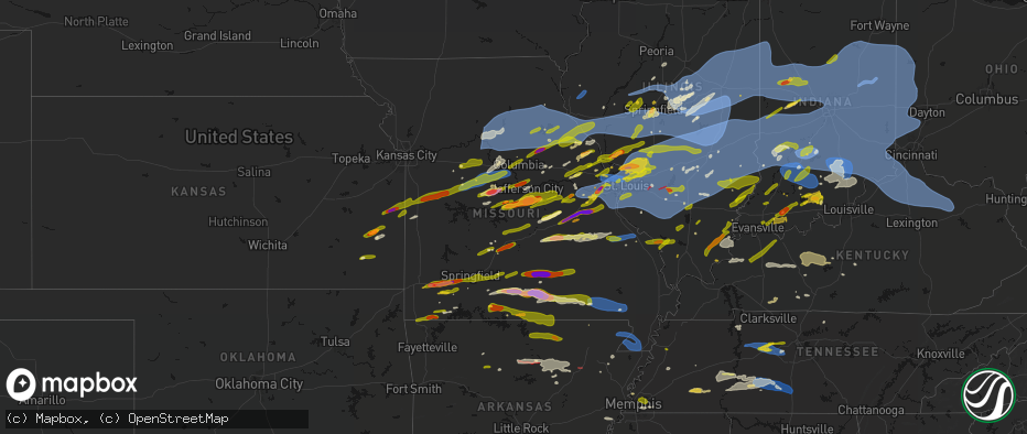
Hail Map in Missouri on April 27, 2026
The weather event in Missouri on April 27, 2026 includes Hail, Wind, and Tornado maps. 15 states and 2,084 cities were impacted and suffered possible damage. The total estimated number of properties impacted is 257,789.
Hail
Wind
Tornado
257,789
Estimated number of impacted properties by a 1.00" hail or larger41,989
Estimated number of impacted properties by a 1.75" hail or larger15,962
Estimated number of impacted properties by a 2.50" hail or largerStorm reports in Missouri
Missouri
| Date | Description |
|---|---|
| 04/27/20266:58 PM CDT | Quarter size hail. |
| 04/27/20266:58 PM CDT | Report from mping: quarter |
| 04/27/20266:56 PM CDT | Report from mping quarter 1.00 in. |
| 04/27/20266:54 PM CDT | A local report indicates 2.00 inch wind near Solo |
| 04/27/20266:54 PM CDT | Report from mping: hen egg |
| 04/27/20266:51 PM CDT | A local report indicates 3.00 inch wind near Elk Creek |
| 04/27/20266:51 PM CDT | A local report indicates 1.50 inch wind near 3 N Simmons |
| 04/27/20266:50 PM CDT | Large tree limb down in ava. |
| 04/27/20266:48 PM CDT | A local report indicates 1.50 inch wind near 4 ENE Brushyknob |
| 04/27/20266:48 PM CDT | Estimated wind coupled with golf ball-sized hail. |
| 04/27/20266:48 PM CDT | Report from mping: half dollar |
| 04/27/20266:46 PM CDT | A local report indicates 1.75 inch wind near 1 ENE Gray Summit |
| 04/27/20266:45 PM CDT | Large tree down on bassett rd. |
| 04/27/20266:45 PM CDT | Tree completely blocking the roadway. |
| 04/27/20266:45 PM CDT | A local report indicates 2.00 inch wind near Brushyknob |
| 04/27/20266:45 PM CDT | 3 trees down at highway 100 and thornton rd. |
| 04/27/20266:45 PM CDT | Time estimated. |
| 04/27/20266:45 PM CDT | Large tree down on thornton rd. |
| 04/27/20266:45 PM CDT | Tree completely blocking the roadway. |
| 04/27/20266:45 PM CDT | A 24-inch tree was uprooted and smashed into a pickup truck. |
| 04/27/20266:45 PM CDT | A local report indicates 2.50 inch wind near 3 E Solo |
| 04/27/20266:44 PM CDT | Report from mping: quarter |
| 04/27/20266:42 PM CDT | A local report indicates 2.50 inch wind near 5 W Drury |
| 04/27/20266:41 PM CDT | Spotter reporting 1 inch hail in ava near hwy 14 and ff. |
| 04/27/20266:40 PM CDT | Large tree blocking the road at webber creek rd and camp mo val rd. Time estimated. |
| 04/27/20266:39 PM CDT | A local report indicates 1.25 inch wind near 2 NNE O'Fallon |
| 04/27/20266:37 PM CDT | A local report indicates 1.00 inch wind near 4 NW Saint Peters |
| 04/27/20266:36 PM CDT | Report from mping: half dollar |
| 04/27/20266:36 PM CDT | Larger size branches down and tree uprooted. |
| 04/27/20266:35 PM CDT | Numerous hailstones measuring 2-inches by 4-inches. |
| 04/27/20266:35 PM CDT | A local report indicates 1.00 inch wind near 2 WNW O'Fallon |
| 04/27/20266:35 PM CDT | A local report indicates 1.25 inch wind near 1 NNE O'Fallon |
| 04/27/20266:30 PM CDT | Near mexico road and salt lick. |
| 04/27/20266:26 PM CDT | A local report indicates 1.25 inch wind near 2 S Gerald |
| 04/27/20266:25 PM CDT | A local report indicates 1.75 inch wind near 3 NNW Leslie |
| 04/27/20266:24 PM CDT | Report from mping: quarter |
| 04/27/20266:23 PM CDT | A local report indicates 1.00 inch wind near Warrenton |
| 04/27/20266:23 PM CDT | 2+ inch hail near bourbon elementary school. |
| 04/27/20266:20 PM CDT | Time estimated. |
| 04/27/20266:20 PM CDT | Report from mping: tennis ball |
| 04/27/20266:16 PM CDT | A local report indicates 3.00 inch wind near Bourbon |
| 04/27/20266:15 PM CDT | Tree down at champion city rd and red oak rd. Time estimated. |
| 04/27/20266:15 PM CDT | Pictures received. Time and size estimated. |
| 04/27/20266:15 PM CDT | Hail varied from pea-size to quarter-size. |
| 04/27/20266:15 PM CDT | A local report indicates 1.75 inch wind near Bourbon |
| 04/27/20266:12 PM CDT | Trooper out with a downed tree on highway 28 near columbia rd in pulaski county. |
| 04/27/20266:02 PM CDT | Ham operator reported quarter-sized hail at cooper hill. |
| 04/27/20265:55 PM CDT | Quarter sized hail in copper hill. Location and time estimated. |
| 04/27/20265:50 PM CDT | Tree down near highway 32 and highway b. |
| 04/27/20265:44 PM CDT | Report from mping golf ball. |
| 04/27/20265:38 PM CDT | A local report indicates 2.50 inch wind near 3 NE Meta |
| 04/27/20265:35 PM CDT | Time estimated. |
| 04/27/20265:32 PM CDT | Report from mping quarter size 1.00 inch. |
| 04/27/20265:31 PM CDT | Report from mping quarter. 1.00 inch. |
| 04/27/20265:30 PM CDT | A local report indicates 1.00 inch wind near 1 N Winfield |
| 04/27/20265:30 PM CDT | Golf ball sized hail reported by fire at 17:30 at the lebanon airport. No picture. |
| 04/27/20265:30 PM CDT | Spotter reporting a 3 foot diameter tree down in rogersville at white oak and bobcat road. |
| 04/27/20265:29 PM CDT | Delayed hail report. |
| 04/27/20265:26 PM CDT | Several trees and limbs down in rogersville. Some limbs took down powerlines. |
| 04/27/20265:18 PM CDT | A local report indicates 1.25 inch wind near 7 S Powell |
| 04/27/20265:18 PM CDT | Quarter to half dollar sized hail 3000 block e. Catalpa sgf. |
| 04/27/20265:18 PM CDT | From spotter estimated 1.00 inch hail. |
| 04/27/20265:18 PM CDT | Amateur radio report 1 foot diameter pine tree down at stanford and ranch. |
| 04/27/20265:15 PM CDT | Report from mping quarter hail of 1.00 in. |
| 04/27/20265:14 PM CDT | Report from mping - quarter |
| 04/27/20265:12 PM CDT | Quarter and golf ball size hail. |
| 04/27/20265:12 PM CDT | Report from mping half dollar size. |
| 04/27/20265:06 PM CDT | Tree and power line down over the roadway. |
| 04/27/20265:05 PM CDT | Powerline down at westview and kansas. |
| 04/27/20265:04 PM CDT | Report from mping quarter size hail of 1.00 in. |
| 04/27/20265:02 PM CDT | Report from mping ping pong ball size hail of 1.50 in. |
| 04/27/20265:00 PM CDT | 3 reports of trees into homes... 60 -70 mph winds and pea sized hail all in monett. |
| 04/27/20264:55 PM CDT | Large tree down. |
| 04/27/20264:54 PM CDT | Republic registered 67mph gust on south and southwest portion of city. Measured hail just over 1inch on west elm. Several trees down south of elm street. Two on houses. |
| 04/27/20264:45 PM CDT | A local report indicates 2.50 inch wind near Mount Vernon |
| 04/27/20264:42 PM CDT | Report from mping golf ball size hail. |
| 04/27/20264:40 PM CDT | Third round of quarter-sized hail. |
| 04/27/20264:36 PM CDT | Numerous reports of tennis ball size hail. |
| 04/27/20264:35 PM CDT | Two reports of trees down around hill top road. |
| 04/27/20264:34 PM CDT | Tree branch on the road... Almost all of road is blocked. |
| 04/27/20264:30 PM CDT | It was bigger than a quarter and smaller than a lime. |
| 04/27/20264:28 PM CDT | Corrects previous hail report from 3 n versailles. About 3 miles north versailles. Hail ranged from versailles 1 inch to 3.5 inch. |
| 04/27/20264:28 PM CDT | About 3 miles north versailles. |
| 04/27/20264:24 PM CDT | From spotter from joplin fire that lives on highway 97... Three miles south of i-44. Had approximately 2-3” hail just now at his house. |
| 04/27/20264:22 PM CDT | Nickle to quarter sized hail reported at i44 34 mm. |
| 04/27/20264:15 PM CDT | Several trees uprooted southeast of sarcoxie. |
| 04/27/20264:15 PM CDT | Heavy rain... Pea size hail... Sporadic quarter size hail... A few strong gusts of wind. |
| 04/27/20264:13 PM CDT | Several trees and limbs down in the southeast part of sarcoxie. |
| 04/27/20264:12 PM CDT | Powerlines down. |
| 04/27/20264:10 PM CDT | Picture received of hail with a quarter for reference. Time estimated. |
| 04/27/20264:10 PM CDT | Corrects previous tstm wnd dmg report from 1 e diamond. Newton county diamond fire units out on trees down and up rooted on j highway east of diamond near deputy drive. |
| 04/27/20264:10 PM CDT | Second round of quarter-sized hail. |
| 04/27/20263:59 PM CDT | A local report indicates 1.00 inch wind near 3 NW Rush Hill |
| 04/27/20263:57 PM CDT | Report from mping: quarter |
| 04/27/20263:55 PM CDT | A local report indicates 1.50 inch wind near 1 WNW Mexico |
| 04/27/20263:54 PM CDT | A local report indicates 1.00 inch wind near Syracuse |
| 04/27/20263:42 PM CDT | A local report indicates 2.00 inch wind near Mexico |
| 04/27/20263:36 PM CDT | Report from asos. |
| 04/27/20263:32 PM CDT | Time estimated from radar. |
| 04/27/20263:19 PM CDT | Time estimated from radar. |
| 04/27/20263:10 PM CDT | Report from mping: quarter |
| 04/27/20263:08 PM CDT | Report from mping: quarter |
| 04/27/20263:00 PM CDT | Power lines down on ethlyn rd. |
| 04/27/20262:56 PM CDT | A local report indicates 1.00 inch wind near Moscow Mills |
| 04/27/20262:23 PM CDT | Report from mping. Time estimated from radar. |
| 04/27/20262:21 PM CDT | A local report indicates 1.00 inch wind near 4 SE Jonesburg |
| 04/27/20262:13 PM CDT | A local report indicates 1.00 inch wind near 5 E Amsterdam |
| 04/27/20261:48 PM CDT | At midland and i-170. |
| 04/27/20261:38 PM CDT | A local report indicates 1.25 inch wind near 1 E Clarkson Valley |
| 04/27/20261:36 PM CDT | A local report indicates 1.00 inch wind near 2 WNW Town And Country |
| 04/27/20261:35 PM CDT | A local report indicates 1.00 inch wind near 1 N Chesterfield |
| 04/27/20261:34 PM CDT | Report from mping: ping pong ball |
| 04/27/202612:25 PM CDT | Report from mping: quarter |
| 04/27/20268:35 AM CDT | A local report indicates 1.00 inch wind near 3 S Hannibal |
| 04/27/20267:51 AM CDT | A local report indicates 65 MPH wind near 3 W Granville |
| 04/27/20267:35 AM CDT | A local report indicates 62 MPH wind near 3 N Moberly |
| 04/27/20267:35 AM CDT | Numerous trees down and some structural damage reported in renick. Time estimated from radar. |
| 04/27/20267:35 AM CDT | Large tree branches snapped. Time estimated from radar. |
| 04/27/20267:33 AM CDT | Large tree split on property and partially across the road. Time estimated from radar. |
| 04/27/20267:31 AM CDT | Large tree limbs broken. Time estimated from radar. |
| 04/27/20267:31 AM CDT | Multiple limbs down. |
| 04/27/20267:30 AM CDT | Flag pole knocked over. Time estimated from radar. |
| 04/27/20267:30 AM CDT | Large branch snapped. Time estimated from radar. |
| 04/27/20267:29 AM CDT | Power pole tilted. Time estimated from radar. |
| 04/27/20267:28 AM CDT | Powerlines down on state route a. Time estimated from radar. |
| 04/27/20267:25 AM CDT | Multiple large 12+ inch tree limbs down. |
| 04/27/20267:24 AM CDT | Several power poles down in slater. |
| 04/27/20267:15 AM CDT | Trees down in roadway. Large branches broken off trees. Time estimated from radar. |
| 04/26/202611:40 PM CDT | Significant roof damage to elementary school. |
| 04/26/202610:03 PM CDT | Large tree limbs down. Time estimated from radar. |
| 04/26/20269:42 PM CDT | 50 to 60 mph wind gusts in stringtown or about 10 miles west of poplar bluff. |
| 04/26/20269:11 PM CDT | Very large live tree snapped... Numerous large branches down off multiple trees. Time estimated from radar. |
| 04/26/20268:40 PM CDT | Report from mping: half dollar |
| 04/26/20268:35 PM CDT | A local report indicates 60 MPH wind near Farmington |
| 04/26/20268:17 PM CDT | A local report indicates 1.00 inch wind near Moody |
| 04/26/20268:15 PM CDT | A local report indicates 2.00 inch wind near West Plains |
| 04/26/20268:10 PM CDT | Trees blown down in ellington. |
| 04/26/20268:00 PM CDT | A local report indicates 1.25 inch wind near Moody |
| 04/26/20267:55 PM CDT | Also reported at 160 and j hwy. |
| 04/26/20267:51 PM CDT | A local report indicates 1.00 inch wind near 1 S White Church |
| 04/26/20267:48 PM CDT | A local report indicates 2.50 inch wind near 2 SE Pomona |
| 04/26/20267:38 PM CDT | A local report indicates 2.50 inch wind near 1 E Willow Springs |
| 04/26/20267:28 PM CDT | A local report indicates 1.00 inch wind near Pomona |
| 04/26/20267:24 PM CDT | A local report indicates 1.50 inch wind near Summersville |
| 04/26/20267:24 PM CDT | A local report indicates 1.75 inch wind near Willow Springs |
| 04/26/20267:20 PM CDT | Power line down on mccausland. |
| 04/26/20267:18 PM CDT | A local report indicates 60 MPH wind near Arnold |
| 04/26/20267:18 PM CDT | Report from mping golf ball 1.75 inch. |
| 04/26/20267:17 PM CDT | On i-55 near arnold. |
| 04/26/20267:12 PM CDT | A local report indicates 2.75 inch wind near 5 SW Eunice |
| 04/26/20267:11 PM CDT | 8-inch diameter trees downed onto cars. |
| 04/26/20267:11 PM CDT | Power outage as the wind gust moved in. |
| 04/26/20267:10 PM CDT | 4 buildings collapsed in florissant. |
| 04/26/20267:00 PM CDT | Corrects previous hail report from 3 e solo time should be 7pm. |
| 04/26/20267:00 PM CDT | Large tree branch split off of trunk. |
| 04/26/20267:00 PM CDT | A local report indicates 2.00 inch wind near Yukon |
All States Impacted by Hail Map on April 27, 2026
Cities Impacted by Hail Map on April 27, 2026
- Hoyleton, IL
- Centralia, IL
- Carlyle, IL
- Jonesboro, IL
- Hoffman, IL
- Macon, MO
- Excello, MO
- McLeansboro, IL
- Macedonia, IL
- Cobden, IL
- Anna, IL
- Dongola, IL
- Edwardsville, IL
- Worden, IL
- Moro, IL
- Brunswick, MO
- Makanda, IL
- Dalton, MO
- Charleston, MO
- East Prairie, MO
- Palmyra, IL
- Carlinville, IL
- Hettick, IL
- Greenfield, IL
- Sandoval, IL
- Buncombe, IL
- Bunker Hill, IL
- Staunton, IL
- Goreville, IL
- Anabel, MO
- Keytesville, MO
- Salisbury, MO
- New Douglas, IL
- Ozark, IL
- Vienna, IL
- Clarence, MO
- Novelty, MO
- Dorsey, IL
- Livingston, IL
- Odin, IL
- Cairo, MO
- Huntsville, MO
- Modesto, IL
- Clifton Hill, MO
- Girard, IL
- Creal Springs, IL
- Simpson, IL
- New Burnside, IL
- Moberly, MO
- Marion, IL
- Mount Olive, IL
- Walshville, IL
- Litchfield, IL
- Knox City, MO
- Shelbyville, MO
- Bethel, MO
- Edina, MO
- Leonard, MO
- Newark, MO
- Jacksonville, MO
- Slater, MO
- Malta Bend, MO
- Carrollton, MO
- Gilliam, MO
- Triplett, MO
- Bosworth, MO
- Marshall, MO
- De Witt, MO
- Miami, MO
- Glasgow, MO
- Mendon, MO
- Clark, MO
- Lentner, MO
- Shelbina, MO
- Callao, MO
- Armstrong, MO
- Bevier, MO
- Higbee, MO
- Harrisburg, MO
- Madison, MO
- Fayette, MO
- Marceline, MO
- New Cambria, MO
- Sturgeon, MO
- Paris, MO
- Holliday, MO
- Chesterfield, IL
- Medora, IL
- Jerseyville, IL
- Rockbridge, IL
- La Belle, MO
- Roodhouse, IL
- Virden, IL
- Burfordville, MO
- Jackson, MO
- Whitewater, MO
- Hunnewell, MO
- Centralia, MO
- Mexico, MO
- Emden, MO
- Thompson, MO
- Stoutsville, MO
- Santa Fe, MO
- Columbia, MO
- Hallsville, MO
- Broughton, IL
- Enfield, IL
- Loami, IL
- Waverly, IL
- Monroe City, MO
- Oak Ridge, MO
- Altenburg, MO
- Center, MO
- Laddonia, MO
- Philadelphia, MO
- Palmyra, MO
- Perry, MO
- Rush Hill, MO
- Farber, MO
- Grand Tower, IL
- Auburn, IL
- Hannibal, MO
- Vandalia, MO
- New London, MO
- Frohna, MO
- New Berlin, IL
- Wolf Lake, IL
- Murrayville, IL
- Curryville, MO
- Frankford, MO
- Gorham, IL
- Murphysboro, IL
- Tipton, MO
- Nokomis, IL
- Morrisonville, IL
- Carbondale, IL
- Pomona, IL
- Pinckneyville, IL
- Coulterville, IL
- Auxvasse, MO
- Chatham, IL
- McClure, IL
- Thebes, IL
- Tamms, IL
- Kinderhook, IL
- Hull, IL
- New Canton, IL
- Ashburn, MO
- Barry, IL
- Louisiana, MO
- Rockport, IL
- Bowling Green, MO
- Glenarm, IL
- Mulkeytown, IL
- Royalton, IL
- Elkville, IL
- De Soto, IL
- Springfield, IL
- Owaneco, IL
- West Frankfort, IL
- Taylorville, IL
- Benton, IL
- Christopher, IL
- Clarksville, MO
- Pleasant Hill, IL
- Griggsville, IL
- Pittsfield, IL
- Nebo, IL
- New Salem, IL
- Assumption, IL
- Rochester, IL
- Scheller, IL
- Sesser, IL
- Baylis, IL
- Waltonville, IL
- Orient, IL
- Mechanicsburg, IL
- Dawson, IL
- Ashley, IL
- Milton, IL
- Pearl, IL
- Hillview, IL
- Pawnee, IL
- Riverton, IL
- Woodlawn, IL
- Thompsonville, IL
- Logan, IL
- Mount Vernon, IL
- Winchester, IL
- Bluffs, IL
- Pleasant Plains, IL
- Athens, IL
- Sherman, IL
- Williamsville, IL
- Pittsburg, IL
- White Hall, IL
- Ashland, IL
- Alexander, IL
- Niantic, IL
- Illiopolis, IL
- Buffalo, IL
- Kampsville, IL
- Johnston City, IL
- Stonefort, IL
- Carrier Mills, IL
- Grantsburg, IL
- Warrensburg, IL
- Petersburg, IL
- Tallula, IL
- Golconda, IL
- Decatur, IL
- Mount Pulaski, IL
- Latham, IL
- Maroa, IL
- Dahlgren, IL
- Ewing, IL
- Galatia, IL
- Harrisburg, IL
- Franklin, IL
- Patterson, IL
- Woodson, IL
- Jacksonville, IL
- Carterville, IL
- Eddyville, IL
- Wrights, IL
- Herod, IL
- Greenview, IL
- Eldorado, IL
- Ingraham, IL
- Clay City, IL
- Dale, IL
- Equality, IL
- Norris City, IL
- Noble, IL
- Omaha, IL
- Cantrall, IL
- Wayne City, IL
- Argenta, IL
- Springerton, IL
- Fidelity, IL
- Junction, IL
- Ridgway, IL
- Bulpitt, IL
- Divernon, IL
- Edinburg, IL
- Waggoner, IL
- Tovey, IL
- Mount Auburn, IL
- Kincaid, IL
- Harvel, IL
- Farmersville, IL
- Thayer, IL
- Fairfield, IL
- Barnhill, IL
- Weldon, IL
- New Haven, IL
- Golden Gate, IL
- Hillsboro, IL
- Raleigh, IL
- Butler, IL
- Irving, IL
- Centertown, MO
- Witt, IL
- Carmi, IL
- Mount Vernon, IN
- Taylor Springs, IL
- Palmer, IL
- Olney, IL
- Fillmore, IL
- Pana, IL
- De Land, IL
- Bingham, IL
- New Harmony, IN
- Shawneetown, IL
- Lakewood, IL
- Tuscola, IL
- Stewardson, IL
- Boody, IL
- Moweaqua, IL
- Macon, IL
- Sadorus, IL
- La Place, IL
- Tolono, IL
- Dalton City, IL
- Mt Zion, IL
- Sullivan, IL
- Arcola, IL
- Strasburg, IL
- Blue Mound, IL
- Bement, IL
- Lovington, IL
- Pesotum, IL
- Tower Hill, IL
- Shelbyville, IL
- Findlay, IL
- Mode, IL
- Gays, IL
- Atwood, IL
- Hammond, IL
- Bethany, IL
- Rosamond, IL
- Arthur, IL
- Stonington, IL
- Windsor, IL
- Ivesdale, IL
- Cerro Gordo, IL
- Beecher City, IL
- Wadesville, IN
- Poseyville, IN
- Ramsey, IL
- Claremont, IL
- Donnellson, IL
- Mulberry Grove, IL
- Greenville, IL
- Sumner, IL
- Evansville, IN
- Cynthiana, IN
- Fredonia, KY
- Marion, KY
- Brownstown, IL
- Tebbetts, MO
- Mokane, MO
- Steedman, MO
- Fulton, MO
- Uniontown, KY
- Henderson, KY
- Corydon, KY
- Newburgh, IN
- Providence, KY
- Princeton, KY
- Saint Peters, MO
- Saint Charles, MO
- Saint Elmo, IL
- Chandler, IN
- Smithboro, IL
- Clay, KY
- Cowden, IL
- Sebree, KY
- Nebo, KY
- Slaughters, KY
- Dixon, KY
- Boonville, IN
- Sigel, IL
- Neoga, IL
- Hindsboro, IL
- Lerna, IL
- Philo, IL
- Camargo, IL
- Toledo, IL
- Sidney, IL
- Villa Grove, IL
- Trilla, IL
- Longview, IL
- Charleston, IL
- Mattoon, IL
- Humboldt, IL
- Manitou, KY
- Vandalia, IL
- Decker, IN
- Hazleton, IN
- Effingham, IL
- Earth City, MO
- Hazelwood, MO
- Bridgeton, MO
- Patoka, IN
- Montrose, IL
- Altamont, IL
- Oakland City, IN
- Francisco, IN
- Owensboro, KY
- Calhoun, KY
- Saint Ann, MO
- Saint Louis, MO
- Maryland Heights, MO
- Chesterfield, MO
- Florissant, MO
- Tennyson, IN
- Princeton, IN
- Monroe City, IN
- Westfield, IL
- Kansas, IL
- Casey, IL
- Ashmore, IL
- Vincennes, IN
- Martinsville, IL
- Marshall, IL
- Gentryville, IN
- Washington, IN
- Wheatland, IN
- Lincoln City, IN
- Chrisney, IN
- Santa Claus, IN
- Lamar, IN
- Dale, IN
- Newton, IL
- Evanston, IN
- Holland, IN
- West Union, IL
- West Liberty, IL
- Willow Hill, IL
- Augusta, MO
- Defiance, MO
- Labadie, MO
- Huntingburg, IN
- Terre Haute, IN
- Kincaid, KS
- Wildwood, MO
- Rockport, IN
- Ballwin, MO
- Salem, IL
- Loogootee, IN
- Saint Anthony, IN
- Ferdinand, IN
- Birdseye, IN
- Centerville, KS
- Blue Mound, KS
- Fairbanks, IN
- Farmersburg, IN
- West York, IL
- Farina, IL
- Kinmundy, IL
- Xenia, IL
- Parker, KS
- Mound City, KS
- Celestine, IN
- Schnellville, IN
- Taswell, IN
- Eckerty, IN
- Pleasanton, KS
- Sullivan, IN
- Jasonville, IN
- Louisville, IL
- Hermann, MO
- New Florence, MO
- Shoals, IN
- Mitchell, IN
- Bedford, IN
- Williams, IN
- Worthington, IN
- Clay City, IN
- Coal City, IN
- Freedom, IN
- La Cygne, KS
- Amoret, MO
- Adrian, MO
- Amsterdam, MO
- Butler, MO
- La Harpe, KS
- Moran, KS
- Bronson, KS
- South Roxana, IL
- Roxana, IL
- Hartford, IL
- Wood River, IL
- Dundas, IL
- Sailor Springs, IL
- Granite City, IL
- High Hill, MO
- Jonesburg, MO
- Rhineland, MO
- Truxton, MO
- Bethalto, IL
- Humboldt, KS
- Linton, IN
- Iola, KS
- Glen Carbon, IL
- Paoli, IN
- English, IN
- Marengo, IN
- Madison, IL
- Warrenton, MO
- Alhambra, IL
- Grafton, IL
- Bicknell, IN
- Rinard, IL
- Maryville, IL
- Collinsville, IL
- Edwardsport, IN
- Flora, IL
- Portage Des Sioux, MO
- Brussels, IL
- Golden Eagle, IL
- O'Fallon, MO
- Troy, IL
- Marine, IL
- Garden City, MO
- Drexel, MO
- Bloomington, IN
- Solsberry, IN
- Springville, IN
- Avoca, IN
- Oolitic, IN
- Troy, MO
- Wright City, MO
- Urich, MO
- Creighton, MO
- Carlisle, IN
- Blairstown, MO
- Chilhowee, MO
- Mapleton, KS
- Wesley, IA
- Montrose, MO
- Sorento, IL
- Hawk Point, MO
- Foristell, MO
- Clinton, MO
- Moscow Mills, MO
- Highland, IL
- Spencer, IN
- Nashville, IN
- Mount Erie, IL
- Lake Saint Louis, MO
- Wentzville, MO
- Lyons, IN
- Elnora, IN
- Newberry, IN
- Prescott, KS
- Fulton, KS
- Odon, IN
- Wooldridge, MO
- Prairie Home, MO
- Centerview, MO
- Jamestown, MO
- Switz City, IN
- Chanute, KS
- Elsmore, KS
- Odessa, MO
- Holden, MO
- Foster, MO
- Windsor, MO
- Leeton, MO
- Calhoun, MO
- Rocheport, MO
- Heltonville, IN
- Bloomfield, IN
- Norman, IN
- Crane, IN
- Concordia, MO
- Old Monroe, MO
- Rich Hill, MO
- Uniontown, KS
- Hume, MO
- Ellery, IL
- Albion, IL
- Calhoun, IL
- Parkersburg, IL
- Warrensburg, MO
- Green Ridge, MO
- Sweet Springs, MO
- West Salem, IL
- Boonville, MO
- Pilot Grove, MO
- Bridgeport, IL
- Montgomery, IN
- Lawrenceville, IL
- Flat Rock, IL
- Owensburg, IN
- Sedalia, MO
- Plainville, IN
- Bunceton, MO
- Fredonia, KS
- Smithton, MO
- Otterville, MO
- Syracuse, MO
- Florence, MO
- Brownstown, IN
- Freetown, IN
- Dow, IL
- Seymour, IN
- La Monte, MO
- Salem, IN
- Godfrey, IL
- Brighton, IL
- Saint Francisville, IL
- Houstonia, MO
- Nelson, MO
- Knob Noster, MO
- Diamond, MO
- Neosho, MO
- Joplin, MO
- Alton, IL
- West Alton, MO
- Elsah, IL
- Campbellsburg, IN
- Vallonia, IN
- Thayer, KS
- Fortuna, MO
- New Franklin, MO
- Scotland, IN
- West Baden Springs, IN
- Orleans, IN
- North Vernon, IN
- Austin, IN
- Scipio, IN
- Paris Crossing, IN
- Columbus, IN
- Crothersville, IN
- Commiskey, IN
- Deputy, IN
- Sarcoxie, MO
- Pierce City, MO
- Wentworth, MO
- Stotts City, MO
- Payson, IL
- Quincy, IL
- Mora, MO
- Cole Camp, MO
- Stover, MO
- Cottage Hills, IL
- Alta Vista, IA
- Granby, MO
- Benton City, MO
- Clarksburg, MO
- Wellsville, MO
- Osceola, MO
- Scottsburg, IN
- Franklin, MO
- Versailles, MO
- Martinsburg, MO
- California, MO
- Bone Gap, IL
- Galesburg, KS
- Saint Paul, KS
- Erie, KS
- Mount Vernon, MO
- Otwell, IN
- Mount Carmel, IL
- Allendale, IL
- Elma, IA
- Petersburg, IN
- Oblong, IL
- Ragsdale, IN
- Quincy, MO
- Latham, MO
- Camp Point, IL
- Aurora, MO
- Marionville, MO
- Billings, MO
- Ash Grove, MO
- Golden, IL
- Chambersburg, IL
- Perry, IL
- Barnett, MO
- Russellville, MO
- Noel, MO
- Kingdom City, MO
- New Hampton, IA
- Cresco, IA
- Shelburn, IN
- Monett, MO
- Clayton, IL
- Stark City, MO
- Browns, IL
- Republic, MO
- Jefferson City, MO
- Hartsburg, MO
- Everton, MO
- Cannelburg, IN
- Pineville, MO
- Ashland, MO
- Montgomery City, MO
- Williamsburg, MO
- Verona, MO
- Eldred, IL
- Gravette, AR
- Sulphur Springs, AR
- Jasper, IN
- Meredosia, IL
- Freistatt, MO
- Lohman, MO
- Gravois Mills, MO
- Eldon, MO
- Rocky Mount, MO
- Middletown, MO
- Brookline, MO
- Springfield, MO
- Rogersville, MO
- Buffalo, MO
- Elkland, MO
- Long Lane, MO
- Phillipsburg, MO
- Bella Vista, AR
- Walnut Grove, MO
- Willard, MO
- Teutopolis, IL
- Powell, MO
- Washburn, MO
- Purdy, MO
- San Jose, IL
- Atkins, IA
- Newhall, IA
- Ridgeway, IA
- Decorah, IA
- Huntsville, IL
- La Prairie, IL
- Dubois, IN
- Annada, MO
- Mason City, IL
- Beardstown, IL
- Arenzville, IL
- Tuscumbia, MO
- Eugene, MO
- Henley, MO
- Pea Ridge, AR
- Seligman, MO
- Virginia, IL
- Exeter, MO
- Cassville, MO
- Crane, MO
- Strafford, MO
- Fordland, MO
- Winfield, MO
- Foley, MO
- Olean, MO
- Nixa, MO
- Ozark, MO
- French Lick, IN
- Lebanon, MO
- Palo, IA
- Cedar Rapids, IA
- Silex, MO
- Pendleton, KY
- Bedford, KY
- Hiawatha, IA
- Shellsburg, IA
- Burnt Prairie, IL
- Grayville, IL
- Crossville, IL
- Mill Shoals, IL
- Saint Thomas, MO
- Batchtown, IL
- Dieterich, IL
- Chapin, IL
- New Bloomfield, MO
- Fairview, MO
- Stoutland, MO
- Montreal, MO
- Richland, MO
- Saint Elizabeth, MO
- Westphalia, MO
- Freeburg, MO
- Koeltztown, MO
- Meta, MO
- Holts Summit, MO
- Robins, IA
- Marion, IA
- Clever, MO
- Mackinaw, IL
- Tremont, IL
- Hopedale, IL
- Carrollton, IL
- Hardin, IL
- Fieldon, IL
- Eolia, MO
- Elsberry, MO
- Morton, IL
- Loose Creek, MO
- Hardinsburg, IN
- Milltown, IN
- Winslow, IN
- Bellmont, IL
- Seymour, MO
- Crocker, MO
- Bonnots Mill, MO
- Linn, MO
- Chamois, MO
- Bland, MO
- Argyle, MO
- Belle, MO
- Kane, IL
- Elkhart, IL
- Bellflower, MO
- Saint James, MO
- Cuba, MO
- Palmyra, IN
- Springville, IA
- Pekin, IN
- Depauw, IN
- Fredericksburg, IN
- Hamburg, IL
- Conway, MO
- Hartville, MO
- Mansfield, MO
- Marshfield, MO
- Dixon, MO
- Mount Sterling, MO
- Morrison, MO
- Owensville, MO
- Piasa, IL
- Shipman, IL
- Vichy, MO
- Truesdale, MO
- Bourbon, MO
- Leasburg, MO
- Laquey, MO
- Vienna, MO
- Velpen, IN
- Stendal, IN
- Rolla, MO
- Middletown, IL
- Oaktown, IN
- Marthasville, MO
- Mountain Grove, MO
- Norwood, MO
- Sullivan, MO
- Rosebud, MO
- Gerald, MO
- Leslie, MO
- New Haven, MO
- Chandlerville, IL
- Oakford, IL
- Lincoln, IL
- Sparta, MO
- Ava, MO
- Milmine, IL
- New Holland, IL
- Owensville, IN
- Chestnut, IL
- Beason, IL
- Bruner, MO
- Berger, MO
- Ponce De Leon, MO
- Highlandville, MO
- Galena, MO
- Clinton, IL
- Kenney, IL
- Saint Clair, MO
- Villa Ridge, MO
- Union, MO
- Robertsville, MO
- Harristown, IL
- Downs, IL
- Wapella, IL
- Waynesville, IL
- Le Roy, IL
- Atlanta, IL
- Heyworth, IL
- McLean, IL
- Catawissa, MO
- Pacific, MO
- Gray Summit, MO
- Eureka, MO
- Cabool, MO
- Graff, MO
- Monticello, IL
- Washington, MO
- Garfield, AR
- Beaufort, MO
- Farmersville, TX
- Shell Knob, MO
- Gillespie, IL
- Raymond, IL
- Edgar Springs, MO
- Reeds Spring, MO
- Rogers, AR
- Salem, MO
- Cape Fair, MO
- Lonedell, MO
- Dittmer, MO
- Grubville, MO
- Richwoods, MO
- Luebbering, MO
- Elk Creek, MO
- Houston, MO
- Solo, MO
- Drury, MO
- Hillsboro, MO
- Cook Sta, MO
- Rosedale, IN
- Clinton, IN
- Branson, MO
- Nilwood, IL
- Grand Prairie, TX
- Dallas, TX
- Irving, TX
- East Alton, IL
- Yukon, MO
- Summersville, MO
- Raymondville, MO
- Eunice, MO
- Oldfield, MO
- Montezuma, IN
- Rockville, IN
- White Heath, IL
- Vanzant, MO
- Dora, MO
- Crescent City, IL
- Arrowsmith, IL
- Farmer City, IL
- Onarga, IL
- Loda, IL
- Mahomet, IL
- Gibson City, IL
- Oreana, IL
- Saybrook, IL
- Mansfield, IL
- Forsyth, IL
- Cisco, IL
- Sibley, IL
- Buckley, IL
- Bellflower, IL
- Fisher, IL
- Foosland, IL
- Paxton, IL
- Roberts, IL
- Melvin, IL
- Elliott, IL
- Dewitt, IL
- Lane, IL
- Saunemin, IL
- Cullom, IL
- Ellsworth, IL
- Cropsey, IL
- Colfax, IL
- Forrest, IL
- Fairbury, IL
- Chenoa, IL
- Cooksville, IL
- Bloomington, IL
- Towanda, IL
- Lexington, IL
- Pontiac, IL
- Gridley, IL
- Normal, IL
- Anchor, IL
- Strawn, IL
- Chatsworth, IL
- Fenton, MO
- High Ridge, MO
- Saint Albans, MO
- Valley Park, MO
- Seymour, IL
- Hartshorn, MO
- Willow Springs, MO
- Celeste, TX
- Macomb, MO
- Rockaway Beach, MO
- Powersite, MO
- Forsyth, MO
- Kirbyville, MO
- Kissee Mills, MO
- Griffin, IN
- Taneyville, MO
- Rowlett, TX
- Richardson, TX
- Bradleyville, MO
- Rueter, MO
- Thornfield, MO
- Theodosia, MO
- Steelville, MO
- Barnhart, MO
- Imperial, MO
- Cedar Hill, MO
- Arnold, MO
- House Springs, MO
- Pevely, MO
- Garland, TX
- Bruceville, IN
- Grantsburg, IN
- Greenville, TX
- Dundee, MS
- Crenshaw, MS
- Sarah, MS
- Cherryville, MO
- Davisville, MO
- Hamel, IL
- Pomona, MO
- Mountain View, MO
- Plano, TX
- Noble, MO
- Wasola, MO
- Gainesville, MO
- Mesquite, TX
- Eminence, MO
- Potosi, MO
- Sachse, TX
- Roachdale, IN
- Russellville, IN
- Isabella, MO
- Wilsonville, IL
- Pocahontas, IL
- Urbana, IL
- Champaign, IL
- Valmeyer, IL
- Oconee, IL
- Wolfe City, TX
- Waterloo, IL
- Columbia, IL
- Millstadt, IL
- East Saint Louis, IL
- East Carondelet, IL
- Dupo, IL
- Herculaneum, MO
- Wylie, TX
- Allen, TX
- Princeton, TX
- Benld, IL
- Sawyerville, IL
- Ladoga, IN
- Viburnum, MO
- Thomasboro, IL
- Piper City, IL
- Rantoul, IL
- Dewey, IL
- Watseka, IL
- Cissna Park, IL
- Gilman, IL
- Gifford, IL
- Rankin, IL
- Thawville, IL
- Ludlow, IL
- Milford, IL
- Bondville, IL
- Potomac, IL
- Newman, IL
- Saint Joseph, IL
- Penfield, IL
- Broadlands, IL
- Savoy, IL
- Ogden, IL
- Royal, IL
- Homer, IL
- Armstrong, IL
- Herrick, IL
- Lovejoy, IL
- Venice, IL
- Belleville, IL
- New Athens, IL
- Smithton, IL
- O'Fallon, IL
- Freeburg, IL
- Fairview Heights, IL
- New Ross, IN
- Commerce, TX
- Coffeen, IL
- De Soto, MO
- Festus, MO
- Panama, IL
- Calhan, CO
- Belgrade, MO
- Pontiac, MO
- Collison, IL
- Hoopeston, IL
- Stockland, IL
- Brook, IN
- Donovan, IL
- Fithian, IL
- Sheldon, IL
- Wellington, IL
- Kentland, IN
- Rossville, IL
- Earl Park, IN
- West Plains, MO
- Hardenville, MO
- Udall, MO
- Caulfield, MO
- Tecumseh, MO
- Rockwall, TX
- Red Bud, IL
- Hecker, IL
- Trenton, IL
- Klondike, TX
- Royse City, TX
- Saint Jacob, IL
- New Baden, IL
- Scott Air Force Base, IL
- Albers, IL
- Aviston, IL
- Mascoutah, IL
- Summerfield, IL
- Breese, IL
- Germantown, IL
- Lebanon, IL
- Bartelso, IL
- Shumway, IL
- Keyesport, IL
- Lenzburg, IL
- Indianola, IL
- Oakwood, IL
- Fairmount, IL
- Allerton, IL
- Zanoni, MO
- Crystal City, MO
- Irondale, MO
- Caledonia, MO
- Cumby, TX
- Peace Valley, MO
- Birch Tree, MO
- Moody, MO
- Pottersville, MO
- Bakersfield, MO
- Ohlman, IL
- Saint Libory, IL
- Marissa, IL
- Oakdale, IL
- Nashville, IL
- Addieville, IL
- Blue Ridge, TX
- Leonard, TX
- Caseyville, IL
- Alton, MO
- Gepp, AR
- Otterbein, IN
- Boswell, IN
- Pine Village, IN
- Templeton, IN
- Catlin, IL
- Covington, IN
- Goodland, IN
- Muncie, IL
- Tilton, IL
- Henning, IL
- West Lebanon, IN
- West Lafayette, IN
- Bismarck, IL
- Ambia, IN
- State Line, IN
- Danville, IL
- Remington, IN
- Fowler, IN
- Williamsport, IN
- Westville, IL
- Brookston, IN
- Oxford, IN
- Attica, IN
- Alvin, IL
- Viola, AR
- Wolcott, IN
- Westpoint, IN
- Metcalf, IL
- Sidell, IL
- Ridge Farm, IL
- Georgetown, IL
- Perrysville, IN
- Hume, IL
- Veedersburg, IN
- Lafayette, IN
- Okawville, IL
- Beckemeyer, IL
- Patoka, IL
- Vernon, IL
- Shobonier, IL
- Koshkonong, MO
- Sturkie, AR
- Fremont, MO
- Winona, MO
- Quinlan, TX
- Terrell, TX
- Newtown, IN
- Wingate, IN
- Park Hills, MO
- Doe Run, MO
- Farmington, MO
- New Richmond, IN
- Romney, IN
- Chrisman, IL
- Bloomingdale, IN
- Kingman, IN
- Hillsboro, IN
- Mellott, IN
- Cayuga, IN
- Dana, IN
- Sulphur Springs, TX
- Bismarck, MO
- Mineral Point, MO
- Leadwood, MO
- Bonne Terre, MO
- Greenup, IL
- Jewett, IL
- Merrimac, WI
- Saint Peter, IL
- Ellington, MO
- Alma, IL
- Tilden, IL
- Sparta, IL
- Baldwin, IL
- Edgewood, IL
- Mason, IL
- Watson, IL
- Brocton, IL
- Richview, IL
- Oakland, IL
- Fults, IL
- Gamaliel, AR
- Dike, TX
- Ladonia, TX
- Crawfordsville, IN
- Waynetown, IN
- Rossville, IN
- Dayton, IN
- Delphi, IN
- Mulberry, IN
- Paris, IL
- Clarks Hill, IN
- New Market, IN
- Darlington, IN
- Alamo, IN
- Linden, IN
- Wheeler, IL
- Walnut Hill, IL
- Iuka, IL
- Hidalgo, IL
- Dix, IL
- Texico, IL
- Kell, IL
- Yale, IL
- Sainte Marie, IL
- Johnsonville, IL
- Irvington, IL
- Sainte Genevieve, MO
- Doniphan, MO
- Van Buren, MO
- Salem, AR
- Du Bois, IL
- Tamaroa, IL
- Bonham, TX
- Prairie Du Rocher, IL
- Lone Oak, TX
- Point, TX
- Sulphur Bluff, TX
- Saltillo, TX
- Frankfort, IN
- Colfax, IN
- Mount Vernon, TX
- Thorntown, IN
- Camp, AR
- Mammoth Spring, AR
- Thayer, MO
- Grandin, MO
- Saint Mary, MO
- Honey Grove, TX
- Emory, TX
- Rio, WI
- Poynette, WI
- Pardeeville, WI
- Greenville, IN
- Wills Point, TX
- Sunnyvale, TX
- Nevada, TX
- Portage, WI
- Baraboo, WI
- Mountain Home, AR
- Ironton, MO
- West Terre Haute, IN
- Dennison, IL
- Vermilion, IL
- New Goshen, IN
- Annapolis, IL
- Waterford, MS
- Potts Camp, MS
- Clarkridge, AR
- Hickory Flat, MS
- Kokomo, IN
- Cutler, IN
- Russiaville, IN
- Forest, IN
- Michigantown, IN
- Sharpsville, IN
- Jamestown, IN
- Kempton, IN
- Kirklin, IN
- Lebanon, IN
- Advance, IN
- Mecca, IN
- Universal, IN
- Perryville, MO
- Du Quoin, IL
- Bonnie, IL
- Keenes, IL
- Bluford, IL
- Dane, WI
- Cambria, WI
- Ravenden, AR
- Bloomsdale, MO
- Cutler, IL
- Brazil, IN
- Fredericktown, MO
- Patterson, MO
- Sims, IL
- Elizabeth, AR
- Myrtle, MS
- Amboy, IN
- Bunker Hill, IN
- Converse, IN
- Greentown, IN
- Blue Mountain, MS
- Waunakee, WI
- Deforest, WI
- Calico Rock, AR
- Geff, IL
- Cisne, IL
- Piedmont, MO
- Pocahontas, AR
- Belle Rive, IL
- Opdyke, IL
- Campbell, TX
- Wabash, IN
- Greenville, MO
- Silva, MO
- Marshall, AR
- Rockwood, IL
- Jacob, IL
- Ava, IL
- Greencastle, IN
- Cory, IN
- Putnamville, IN
- Centerpoint, IN
- Carbon, IN
- Staunton, IN
- Harmony, IN
- Pimento, IN
- Bridgeton, IN
- Robinson, IL
- Knightsville, IN
- Danville, IN
- Amo, IN
- Stoy, IL
- Cloverdale, IN
- Poland, IN
- Bainbridge, IN
- Coatesville, IN
- Palestine, IL
- Fillmore, IN
- Riley, IN
- Reelsville, IN
- Hutsonville, IL
- Merom, IN
- Lewis, IN
- Dolph, AR
- Bexar, AR
- Wideman, AR
- Oxford, AR
- Fairdealing, MO
- Poplar Bluff, MO
- Harviell, MO
- Windfall, IN
- Tipton, IN
- Frankton, IN
- Summitville, IN
- Whitestown, IN
- La Fontaine, IN
- Goldsmith, IN
- Atlanta, IN
- Marion, IN
- Jonesboro, IN
- Fairmount, IN
- Cicero, IN
- Alexandria, IN
- Sweetser, IN
- Arcadia, IN
- Sheridan, IN
- Elwood, IN
- Swayzee, IN
- Westfield, IN
- Noblesville, IN
- Zionsville, IN
- Gaston, IN
- Fowlerton, IN
- Gas City, IN
- Springport, IN
- Muncie, IN
- Warren, IN
- Carmel, IN
- Pendleton, IN
- Lapel, IN
- Lagro, IN
- Matthews, IN
- Shirley, IN
- Van Buren, IN
- Huntington, IN
- Yorktown, IN
- Andrews, IN
- Markleville, IN
- Indianapolis, IN
- Fortville, IN
- Fishers, IN
- Mccordsville, IN
- Middletown, IN
- Upland, IN
- Daleville, IN
- Anderson, IN
- Whittington, IL
- Ina, IL
- Camby, IN
- Gosport, IN
- Stilesville, IN
- Monrovia, IN
- Quincy, IN
- Avon, IN
- Bowling Green, IN
- West Newton, IN
- Hymera, IN
- Patricksburg, IN
- Plainfield, IN
- Clayton, IN
- Brooklyn, IN
- Martinsville, IN
- Ellettsville, IN
- Paragon, IN
- Freelandville, IN
- Mooresville, IN
- Coalmont, IN
- Sandborn, IN
- Dugger, IN
- Ash Flat, AR
- Glencoe, AR
- Horseshoe Bend, AR
- Wiseman, AR
- Neelyville, MO
- Secor, IL
- Congerville, IL
- Eureka, IL
- Goodfield, IL
- Carlock, IL
- Metamora, IL
- Warm Springs, AR
- Cherokee Village, AR
- Hardy, AR
- Armington, IL
- Minier, IL
- Old Appleton, MO
- Uniontown, MO
- Underwood, IN
- Lexington, IN
- Danvers, IL
- Farrar, MO
- Williford, AR
- Maynard, AR
- Ravenden Springs, AR
- Leslie, AR
- Pelsor, AR
- Mount Judea, AR
- Deer Creek, IL
- Washington, IL
- Alto Pass, IL
- Albany, IN
- New Castle, IN
- Eaton, IN
- Selma, IN
- Hartford City, IN
- Montpelier, IN
- Markle, IN
- Mooreland, IN
- Gipsy, MO
- Qulin, MO
- Broseley, MO
- Fisk, MO
- Vendor, AR
- Herrin, IL
- Timbo, AR
- Fox, AR
- Tilly, AR
- Witts Springs, AR
- Hector, AR
- Morgantown, KY
- Lewisburg, KY
- Energy, IL
- Freeman Spur, IL
- Hurst, IL
- Zeigler, IL
- Cambria, IL
- Buckner, IL
- Corning, AR
- Datto, AR
- Biggers, AR
- Mountain View, AR
- Parker City, IN
- Ridgeville, IN
- Farmland, IN
- Knobel, AR
- Peach Orchard, AR
- Cumberland Furnace, TN
- Cunningham, TN
- Paragould, AR
- Poughkeepsie, AR
- Delaplaine, AR
- Imboden, AR
- Bargersville, IN
- Unionville, IN
- Grammer, IN
- Beech Grove, IN
- Knightstown, IN
- Rushville, IN
- New Palestine, IN
- Arlington, IN
- Edinburgh, IN
- Boggstown, IN
- Carthage, IN
- Waldron, IN
- Lewisville, IN
- Elizabethtown, IN
- Greenfield, IN
- Franklin, IN
- Greensburg, IN
- Trafalgar, IN
- Fairland, IN
- Jonesville, IN
- Homer, IN
- Manilla, IN
- Taylorsville, IN
- Mays, IN
- Morgantown, IN
- Shelbyville, IN
- Charlottesville, IN
- Hope, IN
- Morristown, IN
- Stinesville, IN
- Maxwell, IN
- Wilkinson, IN
- Ingalls, IN
- Flat Rock, IN
- Hartsville, IN
- Spiceland, IN
- Fountaintown, IN
- Whiteland, IN
- Greenwood, IN
- Kennard, IN
- Clifford, IN
- Needham, IN
- Milroy, IN
- Saint Paul, IN
- Nineveh, IN
- Gwynneville, IN
- Westport, IN
- Fort Branch, IN
- Straughn, IN
- Venedocia, OH
- Dunkirk, IN
- Bryant, IN
- Greenville, OH
- Uniondale, IN
- Salamonia, IN
- Monroe, IN
- Saint Henry, OH
- Keystone, IN
- Coldwater, OH
- Yorkshire, OH
- Wren, OH
- Modoc, IN
- Celina, OH
- Craigville, IN
- Ansonia, OH
- Osgood, OH
- Mendon, OH
- Berne, IN
- Union City, IN
- Union City, OH
- Rossburg, OH
- Geneva, IN
- Ossian, IN
- Rockford, OH
- Pennville, IN
- Burkettsville, OH
- Willshire, OH
- Poneto, IN
- Fort Recovery, OH
- Liberty Center, IN
- Van Wert, OH
- Bluffton, IN
- Williamsburg, IN
- Petroleum, IN
- Losantville, IN
- Versailles, OH
- Decatur, IN
- Lynn, IN
- Redkey, IN
- Portland, IN
- Saratoga, IN
- Ohio City, OH
- Maria Stein, OH
- Winchester, IN
- Bradford, OH
- Montezuma, OH
- Gettysburg, OH
- New Weston, OH
- Pleasant Grove, AR
- Evening Shade, AR
- Scottsville, KY
- Spurgeon, IN
- Haubstadt, IN
- Elberfeld, IN
- Franklin, AR
- Lafe, AR
- Black Rock, AR
- Rector, AR
- Lynnville, IN
- Scott City, MO
- Miller City, IL
- Olive Branch, IL
- Morganfield, KY
- Marmaduke, AR
- Bernie, MO
- Goodlettsville, TN
- Elizabethtown, IL
- Sturgis, KY
- Cave In Rock, IL
- Smithville, AR
- Walnut Ridge, AR
- Waverly, KY
- Sage, AR
- Melbourne, AR
- Nunnelly, TN
- Eldorado, OH
- Brookville, IN
- Milan, IN
- Laurel, IN
- Metamora, IN
- Milton, IN
- Lawrenceburg, IN
- Webster, IN
- Lewisburg, OH
- Liberty, IN
- New Paris, OH
- Osgood, IN
- Butlerville, IN
- Oldenburg, IN
- Okeana, OH
- Cedar Grove, IN
- Economy, IN
- Falmouth, IN
- New Trenton, IN
- West Harrison, IN
- Batesville, IN
- West College Corner, IN
- Palestine, OH
- Camden, OH
- Fountain City, IN
- Greens Fork, IN
- Holton, IN
- New Madison, OH
- Richmond, IN
- Cambridge City, IN
- Boston, IN
- Hollansburg, OH
- Versailles, IN
- Bath, IN
- Centerville, IN
- Connersville, IN
- Eaton, OH
- Brownsville, IN
- Hagerstown, IN
- West Manchester, OH
- Glenwood, IN
- College Corner, OH
- Oxford, OH
- Arcanum, OH
- Sunman, IN
- Napoleon, IN
- Moores Hill, IN
- Guilford, IN
- Aurora, IN
- Batesville, AR
- Powhatan, AR
- Portia, AR
- Medora, IN
- Dupont, IN
- Vernon, IN
- Madison, IN
- Dillsboro, IN
- New Knoxville, OH
- Chickasaw, OH
- Botkins, OH
- Fort Loramie, OH
- Covington, OH
- Houston, OH
- Spencerville, OH
- Anna, OH
- Saint Marys, OH
- Russia, OH
- Wapakoneta, OH
- Buckland, OH
- Sidney, OH
- Minster, OH
- New Bremen, OH
- Piqua, OH
- Gallatin, TN
- Hendersonville, TN
- Reed, KY
- Charlotte, TN
- Southside, TN
- Shirley, AR
- Kennett, MO
- Senath, MO
- O'Kean, AR
- Beech Grove, AR
- Bono, AR
- Hoxie, AR
- Richland, IN
- Rosiclare, IL
- Marcella, AR
- Olmsted, IL
- Grand Chain, IL
- La Center, KY
- Villa Ridge, IL
- Alicia, AR
- Ashland City, TN
- Chapmansboro, TN
- Jonesboro, AR
- Westmoreland, TN
- Metropolis, IL
- Karnak, IL
- Kevil, KY
- Saint Meinrad, IN
- Tell City, IN
- Salem, KY
- Grandview, IN
- Ramsey, IN
- Hampton, KY
- Smithland, KY
- Borden, IN
- Clarksville, TN
- New Madrid, MO
- Locust Grove, AR
- Sulphur Rock, AR
- Desha, AR
- Steele, MO
- Hornersville, MO
- Blytheville, AR
- Ludlow Falls, OH
- Cross Plains, IN
- Pleasant Hill, OH
- Laura, OH
- Canaan, IN
- West Milton, OH
- Brookville, OH
- Pitsburg, OH
- Troy, OH
- Englewood, OH
- Verona, OH
- Greenway, AR
- Gobler, MO
- Bragg City, MO
- Lewisport, KY
- Charlotte, AR
- Newark, AR
- Madison, TN
- Nashville, TN
- Springfield, TN
- Cedar Hill, TN
- Pleasant View, TN
- Parsons, TN
- Robards, KY
- Pinson, TN
- Joelton, TN
- Cardwell, MO
- Arbyrd, MO
- Scotts Hill, TN
- Medon, TN
- Toone, TN
- Lexington, TN
- Reagan, TN
- Darden, TN
- Edgemont, AR
- Whites Creek, TN
- Vevay, IN
- Milton, KY
- Carrollton, KY
- Ghent, KY
- Bennington, IN
- Sanders, KY
- Campbellsburg, KY
- Owenton, KY
- Turners Station, KY
- Worthville, KY
- Pleasureville, KY
- Perry Park, KY
- Bethlehem, KY
- Warsaw, KY
- Lockport, KY
- Rising Sun, IN
- New Liberty, KY
- Florence, IN
- Frankfort, KY
- Sparta, KY
- Walton, KY
- Verona, KY
- Burlington, KY
- Dry Ridge, KY
- Glencoe, KY
- Union, KY
- Petersburg, KY
- Patriot, IN
- Decaturville, TN
- Brookport, IL
- Henderson, TN
- Sugar Tree, TN
- Burna, KY
- Utica, KY
- Prim, AR
- Higden, AR
- Drasco, AR
- Concord, AR
- Cord, AR
- Bethpage, TN
- Hawesville, KY
- Linden, TN
- Philpot, KY
- Whitesville, KY
- Reynolds Station, KY
- Floral, AR
- Finger, TN
- Brookland, AR
- Dickson, TN
- Tuckerman, AR
- Newport, AR
- McEwen, TN
- Castalian Springs, TN
- Mount Juliet, TN
- Tumbling Shoals, AR
- Morning View, KY
- Crittenden, KY
- Hanson, KY
- Madisonville, KY
- Seven Mile, OH
- Somerville, OH
- Middletown, OH
- Franklin, OH
- Farmersville, OH
- Miamisburg, OH
- Germantown, OH
- Trenton, OH
- Hamilton, OH
- West Alexandria, OH
- Burns, TN
- Cloverport, KY
- White Bluff, TN
- Hartford, KY
- Eddyville, KY
- Olaton, KY
- Livermore, KY
- Bon Aqua, TN
- Centertown, KY
- Hardinsburg, KY
- Falls Of Rough, KY
- Bremen, KY
- Central City, KY
- Sacramento, KY
- Magness, AR
- Williamstown, KY
- Jonesville, KY
- Bethel Springs, TN
- Monette, AR
- Hartsville, TN
- Enville, TN
- Corinth, KY
- Sadieville, KY
- Stamping Ground, KY
- Berry, KY
- Falmouth, KY
- De Mossville, KY
- Cynthiana, KY
- Mercer, TN
- Denmark, TN
- Dyersburg, TN
- Friendship, TN
- Horse Branch, KY
- Caneyville, KY
- Lobelville, TN
- Georgetown, KY
- Pleasant Plains, AR
- Bradford, AR
- Westport, KY
- Powderly, KY
- Greenville, KY
- Old Hickory, TN
- Fordsville, KY
- Butler, KY
- Kuttawa, KY
- Fairview, TN
- Wilburn, AR
- Heber Springs, AR
- Dixon Springs, TN
- Sardis, TN
- Judsonia, AR
- Lake City, AR
- Vanleer, TN
- Kingston Springs, TN
- Beaver Dam, KY
- McHenry, KY
- Alamo, TN
- Pegram, TN
- Brownsville, TN
- Dundee, KY
- Adamsville, TN
- Morris Chapel, TN
- Milledgeville, TN
- Black Oak, AR
- Leachville, AR
- Mount Olivet, KY
- Brooksville, KY
- Carlisle, KY
- Mayslick, KY
- Ewing, KY
- Millersburg, KY
- North Middletown, KY
- Paris, KY
- Moorefield, KY
- Flemingsburg, KY
- Millwood, KY
- Leitchfield, KY
- Clifton, TN
- Dawson Springs, KY
- Pleasant Shade, TN
- Carthage, TN
- Waynesboro, TN
- Hohenwald, TN
- Bath Springs, TN
- Savannah, TN
- Crofton, KY
- White Plains, KY
- Franklin, TN
- Etowah, AR
- Cromwell, KY
- Humboldt, TN
- Gadsden, TN
- Whitleyville, TN
- Gainesboro, TN
- Elkton, KY
- Trenton, TN
- Sharpsburg, KY
- Hillsboro, KY
- Owingsville, KY
- Harrisburg, AR
- Jackson, TN
- Lafayette, TN
- Clarkson, KY
- Brownsville, KY
- Caraway, AR
- Drakesboro, KY
- Browder, KY
- Red Boiling Springs, TN
- Brentwood, TN
- Dover, TN
- Tennessee Ridge, TN
- Trumann, AR
- Manila, AR
- Cumberland City, TN
- Medina, TN
- Summertown, TN
- White Mills, KY
- Sonora, KY
- Big Clifty, KY
- Woodlawn, TN
- Cedar Grove, TN
- Milan, TN
- Lavinia, TN
- Palmyra, TN
- Indian Mound, TN
- Beechmont, KY
- Belton, KY
- Beech Creek, KY
- Dunmor, KY
- Osceola, AR
- Keiser, AR
- Rochester, KY
- Oakfield, TN
- Stewart, TN
- Bee Spring, KY
- Mammoth Cave, KY
- Roundhill, KY
- Munfordville, KY
- Cub Run, KY
- Lepanto, AR
- Dyess, AR
- Marked Tree, AR
- Scottsboro, AL
- Erin, TN
- Hampshire, TN
- Waverly, TN
- Bradford, TN
- Huron, TN
- Beech Bluff, TN
- Oil Trough, AR
- Pembroke, KY
- Bonnieville, KY
- Tyronza, AR
- Joiner, AR
- Cave City, AR
- Hopkinsville, KY
- Lawrenceburg, TN
- Mount Pleasant, TN
- Lynnville, TN
- Ethridge, TN
- Culleoka, TN
- Pulaski, TN
- Belfast, TN
- Cornersville, TN
- Lewisburg, TN
- Trenton, KY
- Horse Cave, KY
- Fackler, AL
- Stevenson, AL
- Hollywood, AL
- Russellville, KY
- Guthrie, KY
- Campbellsville, KY
- Greensburg, KY
- Roby, TX
- Cave City, KY
- Magnolia, KY
- Summersville, KY
- Mount Sherman, KY
- Frenchmans Bayou, AR
- Bassett, AR
- Wilson, AR
- Flat Rock, AL
- Madison, AL
- Decatur, AL
- Only, TN
- Auburn, KY
- Drummonds, TN
- Wynne, AR
- Columbia, TN
- Bryant, AL
- Millington, TN
- Turrell, AR
- Memphis, TN
- Munford, TN
- Marion, AR
- Trenton, GA
- Chattanooga, TN
- Lookout Mountain, TN
- Lookout Mountain, GA
- Flintstone, GA
- Rossville, GA
- Wildwood, GA
- Rotan, TX
- Woodburn, KY
- Rockfield, KY
- Bowling Green, KY
- Brownsburg, IN
- Greenbrier, TN
- Somerville, AL
- Hartselle, AL
- Arlington, TN
- Cordova, TN
- Whiteville, TN
- Oakland, TN
- Eads, TN
- Rossville, TN
- Collierville, TN
- Buck Creek, IN
- Bringhurst, IN
- Southaven, MS
- Walls, MS
- Snyder, TX
- Mason, TN
- Brighton, TN
- Danville, AL
- Moulton, AL
- Trinity, AL
- Batesville, MS
- Courtland, MS
- Sardis, MS
- Aspermont, TX
- Germantown, TN
- Post, TX
- Justiceburg, TX
- Hughes, AR
- Taylor, MS
- Oxford, MS
- Olive Branch, MS
- Crosbyton, TX
- Spur, TX
- Water Valley, MS
- Jayton, TX
- Girard, TX
- Portland, TN
- Tahoka, TX
- Paducah, TX
- Paris, MS
- Banner, MS
- Randolph, MS
- Houlka, MS
- Pontotoc, MS
- Bruce, MS
- Senatobia, MS
- Coffeeville, MS
- Seymour, TX
- Huntsville, AL
- Benjamin, TX
- Thaxton, MS
- Upton, KY
- Pollard, AR