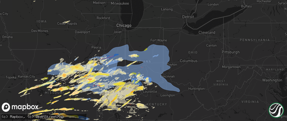
Hail Map in Indiana on April 27, 2026
The weather event in Indiana on April 27, 2026 includes Hail, Wind, and Tornado maps. 15 states and 2,084 cities were impacted and suffered possible damage. The total estimated number of properties impacted is 61,636.
Hail
Wind
Tornado
61,636
Estimated number of impacted properties by a 1.00" hail or larger1,858
Estimated number of impacted properties by a 1.75" hail or larger0
Estimated number of impacted properties by a 2.50" hail or largerStorm reports in Indiana
Indiana
| Date | Description |
|---|---|
| 04/27/20266:57 PM CDT | Power lines down along st. Marys road just north of floyds knobs... In. |
| 04/27/20266:56 PM CDT | Several trees down around a home near the 500 block of highway 64 northeast. |
| 04/27/20266:49 PM CDT | Multiple trees down across northern harrison county. Time estimated from radar. |
| 04/27/20266:38 PM CDT | Two foot diameter trees blown down near milltown. Time estimated from radar. |
| 04/27/20266:38 PM CDT | Additional tree damage along liberty view road north of milltown. Time estimated from radar. |
| 04/27/20266:34 PM CDT | Time estimated by radar. |
| 04/27/20266:30 PM CDT | Time estimated by radar. |
| 04/27/20266:27 PM CDT | Tree down on power lines at corner of market st and 2nd st. Time estimated by radar. |
| 04/27/20266:25 PM CDT | Numerous trees down along state road 64 west of english. Time estimated from radar. |
| 04/27/20266:25 PM CDT | Numerous trees down along state road 64 west of english. Time estimated from radar. |
| 04/27/20266:24 PM CDT | Tree fell down on a home near the 300 block of myrtle st. Time estimated by radar. |
| 04/27/20266:20 PM CDT | Large tree down in yard near the 3500 block of stenger lane. |
| 04/27/20266:17 PM CDT | A local report indicates 62 MPH wind near 1 W Cementville |
| 04/27/20266:05 PM CDT | Tree on power lines on st. Marys rd... Time estimated by radar. |
| 04/27/20265:56 PM CDT | Corrects previous tstm wnd dmg report from 2 nnw greenville. Tree was reported down on blk voyles rd... Time estimated by radar. |
| 04/27/20265:56 PM CDT | Tree reported down on power lines... Time estimated by radar. |
| 04/27/20265:56 PM CDT | Corrects previous tstm wnd dmg report from greenville. Tree reported down on power lines at corner of pekin rd and clark st... Time estimated by radar. |
| 04/27/20265:31 PM CDT | Multiple trees down in the greenfield township near west county road 560 south. |
| 04/27/20265:23 PM CDT | Corrects previous tstm wnd dmg report from 1 s birdseye. Tree down blocking both lanes on sr 145 s of conservation club rd. Time estimated by radar. |
| 04/27/20265:23 PM CDT | Tree down blocking both lanes. |
| 04/27/20265:06 PM CDT | Tree down on e 125 s. |
| 04/27/20264:56 PM CDT | Tree down blocking traffic and also down across potential power lines. |
| 04/27/20264:56 PM CDT | Corrects previous tstm wnd dmg report from 1 s thales. Tree down blocking traffic and also down across potential power lines on n hickory rd. |
| 04/27/20264:54 PM CDT | Several trees and power lines down along eagle hollow road. |
| 04/27/20264:05 PM CDT | Multiple trees down just south of french lick along sr 145. |
| 04/27/20264:04 PM CDT | A local report indicates 60 MPH wind near 2 NE Seymour |
| 04/27/20264:00 PM CDT | Damage to multiple power poles and house roofs. Time based on radar. |
| 04/27/20263:52 PM CDT | 30 power poles down. Time estimated from radar. |
| 04/27/20263:44 PM CDT | An ef-1 tornado with path length of 2.16 miles and path width of 100 yards began at this location. The peak winds were 105 mph with damage including snapped trees and t |
| 04/27/20263:43 PM CDT | Tree over roadway. |
| 04/27/20263:28 PM CDT | Time estimated from radar. |
| 04/27/20263:02 PM CDT | Report from mping: quarter |
| 04/27/20262:57 PM CDT | Pea sized hail also. |
| 04/27/20262:54 PM CDT | Report from mping: half dollar |
| 04/27/20262:48 PM CDT | Report from mping: quarter |
| 04/27/20262:47 PM CDT | Report from mping: quarter |
| 04/27/20262:44 PM CDT | Report from mping: quarter |
| 04/27/20262:43 PM CDT | At kbmg. |
| 04/27/20262:31 PM CDT | Power lines down. Time estimated based on radar. |
| 04/27/20262:16 PM CDT | Time estimated from radar. |
| 04/27/20262:01 PM CDT | A local report indicates 1.00 inch wind near 2 SSE Silverville |
| 04/27/20261:55 PM CDT | Via social media. Time estimated from radar. |
| 04/27/20261:44 PM CDT | Several large tree limbs downed in town. Time estimated from radar. |
| 04/27/20261:28 PM CDT | A local report indicates 1.00 inch wind near Elnora |
| 04/27/20261:15 PM CDT | A local report indicates 1.75 inch wind near Holland |
| 04/27/20261:15 PM CDT | Updates previous hail report from holland. Hail damage to a couple of homes also occurred. |
| 04/27/20261:10 PM CDT | A local report indicates 1.00 inch wind near Washington |
| 04/27/20261:05 PM CDT | A local report indicates 1.25 inch wind near 7 WNW Dale |
| 04/27/202612:37 PM CDT | A local report indicates 1.00 inch wind near 3 NNE Newburgh |
| 04/27/202612:32 PM CDT | A local report indicates 1.00 inch wind near Oakland City |
| 04/27/202612:23 PM CDT | A local report indicates 1.00 inch wind near 2 E Princeton |
| 04/27/202612:23 PM CDT | A local report indicates 1.00 inch wind near 4 NE Melody Hill |
| 04/27/20261:30 AM CDT | Large tree down across both lanes. |
| 04/27/202612:10 AM CDT | Three barns damaged. Time estimated from radar. |
| 04/26/202611:54 PM CDT | Trees down in drewersburg. Time estimated from radar. |
| 04/26/202611:40 PM CDT | Trees down throughout batesville. Time estimated from radar. |
| 04/26/202611:25 PM CDT | Two large trees uprooted and several with snapped tops. |
| 04/26/202611:12 PM CDT | Trees down in glen miller park. Time estimated from radar. |
| 04/26/202611:05 PM CDT | Measured at kser awos. |
| 04/26/202611:02 PM CDT | Tree down reported in fountain city. Time estimated from radar. |
| 04/26/202611:01 PM CDT | 15inch diameter tree down. |
| 04/26/202611:00 PM CDT | Tree downed on a camper. Additional sporadic damage in the western and southern portions of the county. |
| 04/26/202611:00 PM CDT | Trees down just south of fayette central elementary school. Time estimated from radar. |
| 04/26/202610:52 PM CDT | Wires down. Time estimated from radar. |
| 04/26/202610:45 PM CDT | Trees downed. Time estimated from radar. |
| 04/26/202610:35 PM CDT | Late report of t-storm winds damaging tree onto power line. Overall dozens of trees onto roads in lawrence county from evening storms. |
| 04/26/202610:35 PM CDT | Late report of t-storm winds downing tree onto house. Time estimated from radar. |
| 04/26/202610:32 PM CDT | Corrects previous non-tstm late report to tstm wnd dmg at 5 sw ellettsville. T-storm winds downed tree into home which allowed rain water to flood into basement. |
| 04/26/202610:30 PM CDT | Asos station kgez shelbyville. |
| 04/26/202610:28 PM CDT | A local report indicates 61 MPH wind near Hartford City |
| 04/26/202610:22 PM CDT | 2 trees downed... One near 5th street and one near 15th street. |
| 04/26/202610:18 PM CDT | Irrigation leg knocked over by thunderstorm winds. Tree and power pole damage also reported in the area. |
| 04/26/202610:17 PM CDT | Tree down over road. Time estimated from radar. |
| 04/26/202610:10 PM CDT | 2 trees downed... One near 5th street and one near 15th street. |
| 04/26/202610:08 PM CDT | Corrects time of previous tstm wnd gst report from hartford city. Time estimated via radar. |
| 04/26/202610:02 PM CDT | 18 inch diameter tree downed. |
| 04/26/20269:59 PM CDT | 3 inch tree limb downed. |
| 04/26/20269:55 PM CDT | A local report indicates 61 MPH wind near Martinsville |
| 04/26/20269:54 PM CDT | An ef-0 tornado with path length of 0.84 miles and path width of 50 yards began at this location. The peak winds were 85 mph with most damage associated with tree damag |
| 04/26/20269:53 PM CDT | Report of damage east of eastbrook. Time estimated via radar. Damage to a shed and fence at one home and a window blown out at another. A barn in the area also has dama |
| 04/26/20269:52 PM CDT | Broadcast media estimates 60 mph wind gusts on i-69 at mile marker 269 |
| 04/26/20269:52 PM CDT | Damage just east of eastbrook. Time estimated via radar. Damage to a shed and fence at one home and a window blown out of another. A barn was also damaged in the area. |
| 04/26/20269:50 PM CDT | Report of a 70.7 mph gust recorded on a personal weather station. Time estimated via radar. |
| 04/26/20269:50 PM CDT | An ef-1 tornado with path length of 2.73 miles and path width of 150 yards began at this location. The peak winds were 105 mph with most damage being associated with sn |
| 04/26/20269:50 PM CDT | Video on facebook shows a large tree falling in gas city. Time estimated via radar. |
| 04/26/20269:50 PM CDT | Report of a tree down and damage to a porch on the east side of marion. Time estimated via radar. |
| 04/26/20269:43 PM CDT | Late report of thunderstorm winds damaging trees. Time estimated from radar. |
| 04/26/20269:30 PM CDT | A local report indicates 70 MPH wind near 4 SW Greentown |
| 04/26/20269:24 PM CDT | Semi flipped on us 31. |
| 04/26/20269:10 PM CDT | 18 inch tree downed. |
| 04/26/20269:10 PM CDT | A local report indicates 70 MPH wind near 1 NW North Terre Haute |
| 04/26/20269:04 PM CDT | Estimated 60 to 70 mph. |
| 04/26/20269:00 PM CDT | A local report indicates 60 MPH wind near 2 W Frankfort |
| 04/26/20268:57 PM CDT | 18 to 20 inch healthy tree limb downed near us 52. |
| 04/26/20268:52 PM CDT | 20 to 24 inch live tree limb downed. |
| 04/26/20268:45 PM CDT | Trees and powerlines down on n cr 600 e between logansport rd and division rd. |
| 04/26/20268:38 PM CDT | 50-55 mph winds. |
| 04/26/20268:27 PM CDT | Klaf asos. |
| 04/26/20268:27 PM CDT | Multiple trees snapped and uprooted with power lines down. |
| 04/26/20268:10 PM CDT | Late report of t-storm winds downing tree onto county road 100 west at overpass over i-74. |
| 04/26/20268:05 PM CDT | A 60 mph gust was recorded by a private weather station along us-41 southwest of fowler. |
| 04/26/20267:47 PM CDT | Trees down near reunion street. |
| 04/26/20267:47 PM CDT | Trees down across fredericksburg... In near e washington street. |
| 04/26/20267:41 PM CDT | Corrects previous late report non-tstm report from 3 s new ross to tstm wnd dmg. T-storm winds downed trees and power lines. |
| 04/26/20267:15 PM CDT | 55-65 mph. |
| 04/26/20267:14 PM CDT | Late report of t-storm winds downed tree at southwest purdue ag center. Time estimated from radar. |
| 04/26/20267:08 PM CDT | A tree was downed across hay market dr in jeffersonville... In. |
| 04/26/20267:08 PM CDT | Power lines down along coopers lane in jeffersonville... In. |
| 04/26/20267:07 PM CDT | Multiple trees down near dutch creek rd. Time estimated by radar. |
| 04/26/20267:05 PM CDT | Reported tree down on a vehicle near bradford rd and kiesler rd. |
| 04/26/20267:01 PM CDT | Corrects previous hail report from valeene. Time estimated by radar. |
All States Impacted by Hail Map on April 27, 2026
Cities Impacted by Hail Map on April 27, 2026
- Hoyleton, IL
- Centralia, IL
- Carlyle, IL
- Jonesboro, IL
- Hoffman, IL
- Macon, MO
- Excello, MO
- McLeansboro, IL
- Macedonia, IL
- Cobden, IL
- Anna, IL
- Dongola, IL
- Edwardsville, IL
- Worden, IL
- Moro, IL
- Brunswick, MO
- Makanda, IL
- Dalton, MO
- Charleston, MO
- East Prairie, MO
- Palmyra, IL
- Carlinville, IL
- Hettick, IL
- Greenfield, IL
- Sandoval, IL
- Buncombe, IL
- Bunker Hill, IL
- Staunton, IL
- Goreville, IL
- Anabel, MO
- Keytesville, MO
- Salisbury, MO
- New Douglas, IL
- Ozark, IL
- Vienna, IL
- Clarence, MO
- Novelty, MO
- Dorsey, IL
- Livingston, IL
- Odin, IL
- Cairo, MO
- Huntsville, MO
- Modesto, IL
- Clifton Hill, MO
- Girard, IL
- Creal Springs, IL
- Simpson, IL
- New Burnside, IL
- Moberly, MO
- Marion, IL
- Mount Olive, IL
- Walshville, IL
- Litchfield, IL
- Knox City, MO
- Shelbyville, MO
- Bethel, MO
- Edina, MO
- Leonard, MO
- Newark, MO
- Jacksonville, MO
- Slater, MO
- Malta Bend, MO
- Carrollton, MO
- Gilliam, MO
- Triplett, MO
- Bosworth, MO
- Marshall, MO
- De Witt, MO
- Miami, MO
- Glasgow, MO
- Mendon, MO
- Clark, MO
- Lentner, MO
- Shelbina, MO
- Callao, MO
- Armstrong, MO
- Bevier, MO
- Higbee, MO
- Harrisburg, MO
- Madison, MO
- Fayette, MO
- Marceline, MO
- New Cambria, MO
- Sturgeon, MO
- Paris, MO
- Holliday, MO
- Chesterfield, IL
- Medora, IL
- Jerseyville, IL
- Rockbridge, IL
- La Belle, MO
- Roodhouse, IL
- Virden, IL
- Burfordville, MO
- Jackson, MO
- Whitewater, MO
- Hunnewell, MO
- Centralia, MO
- Mexico, MO
- Emden, MO
- Thompson, MO
- Stoutsville, MO
- Santa Fe, MO
- Columbia, MO
- Hallsville, MO
- Broughton, IL
- Enfield, IL
- Loami, IL
- Waverly, IL
- Monroe City, MO
- Oak Ridge, MO
- Altenburg, MO
- Center, MO
- Laddonia, MO
- Philadelphia, MO
- Palmyra, MO
- Perry, MO
- Rush Hill, MO
- Farber, MO
- Grand Tower, IL
- Auburn, IL
- Hannibal, MO
- Vandalia, MO
- New London, MO
- Frohna, MO
- New Berlin, IL
- Wolf Lake, IL
- Murrayville, IL
- Curryville, MO
- Frankford, MO
- Gorham, IL
- Murphysboro, IL
- Tipton, MO
- Nokomis, IL
- Morrisonville, IL
- Carbondale, IL
- Pomona, IL
- Pinckneyville, IL
- Coulterville, IL
- Auxvasse, MO
- Chatham, IL
- McClure, IL
- Thebes, IL
- Tamms, IL
- Kinderhook, IL
- Hull, IL
- New Canton, IL
- Ashburn, MO
- Barry, IL
- Louisiana, MO
- Rockport, IL
- Bowling Green, MO
- Glenarm, IL
- Mulkeytown, IL
- Royalton, IL
- Elkville, IL
- De Soto, IL
- Springfield, IL
- Owaneco, IL
- West Frankfort, IL
- Taylorville, IL
- Benton, IL
- Christopher, IL
- Clarksville, MO
- Pleasant Hill, IL
- Griggsville, IL
- Pittsfield, IL
- Nebo, IL
- New Salem, IL
- Assumption, IL
- Rochester, IL
- Scheller, IL
- Sesser, IL
- Baylis, IL
- Waltonville, IL
- Orient, IL
- Mechanicsburg, IL
- Dawson, IL
- Ashley, IL
- Milton, IL
- Pearl, IL
- Hillview, IL
- Pawnee, IL
- Riverton, IL
- Woodlawn, IL
- Thompsonville, IL
- Logan, IL
- Mount Vernon, IL
- Winchester, IL
- Bluffs, IL
- Pleasant Plains, IL
- Athens, IL
- Sherman, IL
- Williamsville, IL
- Pittsburg, IL
- White Hall, IL
- Ashland, IL
- Alexander, IL
- Niantic, IL
- Illiopolis, IL
- Buffalo, IL
- Kampsville, IL
- Johnston City, IL
- Stonefort, IL
- Carrier Mills, IL
- Grantsburg, IL
- Warrensburg, IL
- Petersburg, IL
- Tallula, IL
- Golconda, IL
- Decatur, IL
- Mount Pulaski, IL
- Latham, IL
- Maroa, IL
- Dahlgren, IL
- Ewing, IL
- Galatia, IL
- Harrisburg, IL
- Franklin, IL
- Patterson, IL
- Woodson, IL
- Jacksonville, IL
- Carterville, IL
- Eddyville, IL
- Wrights, IL
- Herod, IL
- Greenview, IL
- Eldorado, IL
- Ingraham, IL
- Clay City, IL
- Dale, IL
- Equality, IL
- Norris City, IL
- Noble, IL
- Omaha, IL
- Cantrall, IL
- Wayne City, IL
- Argenta, IL
- Springerton, IL
- Fidelity, IL
- Junction, IL
- Ridgway, IL
- Bulpitt, IL
- Divernon, IL
- Edinburg, IL
- Waggoner, IL
- Tovey, IL
- Mount Auburn, IL
- Kincaid, IL
- Harvel, IL
- Farmersville, IL
- Thayer, IL
- Fairfield, IL
- Barnhill, IL
- Weldon, IL
- New Haven, IL
- Golden Gate, IL
- Hillsboro, IL
- Raleigh, IL
- Butler, IL
- Irving, IL
- Centertown, MO
- Witt, IL
- Carmi, IL
- Mount Vernon, IN
- Taylor Springs, IL
- Palmer, IL
- Olney, IL
- Fillmore, IL
- Pana, IL
- De Land, IL
- Bingham, IL
- New Harmony, IN
- Shawneetown, IL
- Lakewood, IL
- Tuscola, IL
- Stewardson, IL
- Boody, IL
- Moweaqua, IL
- Macon, IL
- Sadorus, IL
- La Place, IL
- Tolono, IL
- Dalton City, IL
- Mt Zion, IL
- Sullivan, IL
- Arcola, IL
- Strasburg, IL
- Blue Mound, IL
- Bement, IL
- Lovington, IL
- Pesotum, IL
- Tower Hill, IL
- Shelbyville, IL
- Findlay, IL
- Mode, IL
- Gays, IL
- Atwood, IL
- Hammond, IL
- Bethany, IL
- Rosamond, IL
- Arthur, IL
- Stonington, IL
- Windsor, IL
- Ivesdale, IL
- Cerro Gordo, IL
- Beecher City, IL
- Wadesville, IN
- Poseyville, IN
- Ramsey, IL
- Claremont, IL
- Donnellson, IL
- Mulberry Grove, IL
- Greenville, IL
- Sumner, IL
- Evansville, IN
- Cynthiana, IN
- Fredonia, KY
- Marion, KY
- Brownstown, IL
- Tebbetts, MO
- Mokane, MO
- Steedman, MO
- Fulton, MO
- Uniontown, KY
- Henderson, KY
- Corydon, KY
- Newburgh, IN
- Providence, KY
- Princeton, KY
- Saint Peters, MO
- Saint Charles, MO
- Saint Elmo, IL
- Chandler, IN
- Smithboro, IL
- Clay, KY
- Cowden, IL
- Sebree, KY
- Nebo, KY
- Slaughters, KY
- Dixon, KY
- Boonville, IN
- Sigel, IL
- Neoga, IL
- Hindsboro, IL
- Lerna, IL
- Philo, IL
- Camargo, IL
- Toledo, IL
- Sidney, IL
- Villa Grove, IL
- Trilla, IL
- Longview, IL
- Charleston, IL
- Mattoon, IL
- Humboldt, IL
- Manitou, KY
- Vandalia, IL
- Decker, IN
- Hazleton, IN
- Effingham, IL
- Earth City, MO
- Hazelwood, MO
- Bridgeton, MO
- Patoka, IN
- Montrose, IL
- Altamont, IL
- Oakland City, IN
- Francisco, IN
- Owensboro, KY
- Calhoun, KY
- Saint Ann, MO
- Saint Louis, MO
- Maryland Heights, MO
- Chesterfield, MO
- Florissant, MO
- Tennyson, IN
- Princeton, IN
- Monroe City, IN
- Westfield, IL
- Kansas, IL
- Casey, IL
- Ashmore, IL
- Vincennes, IN
- Martinsville, IL
- Marshall, IL
- Gentryville, IN
- Washington, IN
- Wheatland, IN
- Lincoln City, IN
- Chrisney, IN
- Santa Claus, IN
- Lamar, IN
- Dale, IN
- Newton, IL
- Evanston, IN
- Holland, IN
- West Union, IL
- West Liberty, IL
- Willow Hill, IL
- Augusta, MO
- Defiance, MO
- Labadie, MO
- Huntingburg, IN
- Terre Haute, IN
- Kincaid, KS
- Wildwood, MO
- Rockport, IN
- Ballwin, MO
- Salem, IL
- Loogootee, IN
- Saint Anthony, IN
- Ferdinand, IN
- Birdseye, IN
- Centerville, KS
- Blue Mound, KS
- Fairbanks, IN
- Farmersburg, IN
- West York, IL
- Farina, IL
- Kinmundy, IL
- Xenia, IL
- Parker, KS
- Mound City, KS
- Celestine, IN
- Schnellville, IN
- Taswell, IN
- Eckerty, IN
- Pleasanton, KS
- Sullivan, IN
- Jasonville, IN
- Louisville, IL
- Hermann, MO
- New Florence, MO
- Shoals, IN
- Mitchell, IN
- Bedford, IN
- Williams, IN
- Worthington, IN
- Clay City, IN
- Coal City, IN
- Freedom, IN
- La Cygne, KS
- Amoret, MO
- Adrian, MO
- Amsterdam, MO
- Butler, MO
- La Harpe, KS
- Moran, KS
- Bronson, KS
- South Roxana, IL
- Roxana, IL
- Hartford, IL
- Wood River, IL
- Dundas, IL
- Sailor Springs, IL
- Granite City, IL
- High Hill, MO
- Jonesburg, MO
- Rhineland, MO
- Truxton, MO
- Bethalto, IL
- Humboldt, KS
- Linton, IN
- Iola, KS
- Glen Carbon, IL
- Paoli, IN
- English, IN
- Marengo, IN
- Madison, IL
- Warrenton, MO
- Alhambra, IL
- Grafton, IL
- Bicknell, IN
- Rinard, IL
- Maryville, IL
- Collinsville, IL
- Edwardsport, IN
- Flora, IL
- Portage Des Sioux, MO
- Brussels, IL
- Golden Eagle, IL
- O'Fallon, MO
- Troy, IL
- Marine, IL
- Garden City, MO
- Drexel, MO
- Bloomington, IN
- Solsberry, IN
- Springville, IN
- Avoca, IN
- Oolitic, IN
- Troy, MO
- Wright City, MO
- Urich, MO
- Creighton, MO
- Carlisle, IN
- Blairstown, MO
- Chilhowee, MO
- Mapleton, KS
- Wesley, IA
- Montrose, MO
- Sorento, IL
- Hawk Point, MO
- Foristell, MO
- Clinton, MO
- Moscow Mills, MO
- Highland, IL
- Spencer, IN
- Nashville, IN
- Mount Erie, IL
- Lake Saint Louis, MO
- Wentzville, MO
- Lyons, IN
- Elnora, IN
- Newberry, IN
- Prescott, KS
- Fulton, KS
- Odon, IN
- Wooldridge, MO
- Prairie Home, MO
- Centerview, MO
- Jamestown, MO
- Switz City, IN
- Chanute, KS
- Elsmore, KS
- Odessa, MO
- Holden, MO
- Foster, MO
- Windsor, MO
- Leeton, MO
- Calhoun, MO
- Rocheport, MO
- Heltonville, IN
- Bloomfield, IN
- Norman, IN
- Crane, IN
- Concordia, MO
- Old Monroe, MO
- Rich Hill, MO
- Uniontown, KS
- Hume, MO
- Ellery, IL
- Albion, IL
- Calhoun, IL
- Parkersburg, IL
- Warrensburg, MO
- Green Ridge, MO
- Sweet Springs, MO
- West Salem, IL
- Boonville, MO
- Pilot Grove, MO
- Bridgeport, IL
- Montgomery, IN
- Lawrenceville, IL
- Flat Rock, IL
- Owensburg, IN
- Sedalia, MO
- Plainville, IN
- Bunceton, MO
- Fredonia, KS
- Smithton, MO
- Otterville, MO
- Syracuse, MO
- Florence, MO
- Brownstown, IN
- Freetown, IN
- Dow, IL
- Seymour, IN
- La Monte, MO
- Salem, IN
- Godfrey, IL
- Brighton, IL
- Saint Francisville, IL
- Houstonia, MO
- Nelson, MO
- Knob Noster, MO
- Diamond, MO
- Neosho, MO
- Joplin, MO
- Alton, IL
- West Alton, MO
- Elsah, IL
- Campbellsburg, IN
- Vallonia, IN
- Thayer, KS
- Fortuna, MO
- New Franklin, MO
- Scotland, IN
- West Baden Springs, IN
- Orleans, IN
- North Vernon, IN
- Austin, IN
- Scipio, IN
- Paris Crossing, IN
- Columbus, IN
- Crothersville, IN
- Commiskey, IN
- Deputy, IN
- Sarcoxie, MO
- Pierce City, MO
- Wentworth, MO
- Stotts City, MO
- Payson, IL
- Quincy, IL
- Mora, MO
- Cole Camp, MO
- Stover, MO
- Cottage Hills, IL
- Alta Vista, IA
- Granby, MO
- Benton City, MO
- Clarksburg, MO
- Wellsville, MO
- Osceola, MO
- Scottsburg, IN
- Franklin, MO
- Versailles, MO
- Martinsburg, MO
- California, MO
- Bone Gap, IL
- Galesburg, KS
- Saint Paul, KS
- Erie, KS
- Mount Vernon, MO
- Otwell, IN
- Mount Carmel, IL
- Allendale, IL
- Elma, IA
- Petersburg, IN
- Oblong, IL
- Ragsdale, IN
- Quincy, MO
- Latham, MO
- Camp Point, IL
- Aurora, MO
- Marionville, MO
- Billings, MO
- Ash Grove, MO
- Golden, IL
- Chambersburg, IL
- Perry, IL
- Barnett, MO
- Russellville, MO
- Noel, MO
- Kingdom City, MO
- New Hampton, IA
- Cresco, IA
- Shelburn, IN
- Monett, MO
- Clayton, IL
- Stark City, MO
- Browns, IL
- Republic, MO
- Jefferson City, MO
- Hartsburg, MO
- Everton, MO
- Cannelburg, IN
- Pineville, MO
- Ashland, MO
- Montgomery City, MO
- Williamsburg, MO
- Verona, MO
- Eldred, IL
- Gravette, AR
- Sulphur Springs, AR
- Jasper, IN
- Meredosia, IL
- Freistatt, MO
- Lohman, MO
- Gravois Mills, MO
- Eldon, MO
- Rocky Mount, MO
- Middletown, MO
- Brookline, MO
- Springfield, MO
- Rogersville, MO
- Buffalo, MO
- Elkland, MO
- Long Lane, MO
- Phillipsburg, MO
- Bella Vista, AR
- Walnut Grove, MO
- Willard, MO
- Teutopolis, IL
- Powell, MO
- Washburn, MO
- Purdy, MO
- San Jose, IL
- Atkins, IA
- Newhall, IA
- Ridgeway, IA
- Decorah, IA
- Huntsville, IL
- La Prairie, IL
- Dubois, IN
- Annada, MO
- Mason City, IL
- Beardstown, IL
- Arenzville, IL
- Tuscumbia, MO
- Eugene, MO
- Henley, MO
- Pea Ridge, AR
- Seligman, MO
- Virginia, IL
- Exeter, MO
- Cassville, MO
- Crane, MO
- Strafford, MO
- Fordland, MO
- Winfield, MO
- Foley, MO
- Olean, MO
- Nixa, MO
- Ozark, MO
- French Lick, IN
- Lebanon, MO
- Palo, IA
- Cedar Rapids, IA
- Silex, MO
- Pendleton, KY
- Bedford, KY
- Hiawatha, IA
- Shellsburg, IA
- Burnt Prairie, IL
- Grayville, IL
- Crossville, IL
- Mill Shoals, IL
- Saint Thomas, MO
- Batchtown, IL
- Dieterich, IL
- Chapin, IL
- New Bloomfield, MO
- Fairview, MO
- Stoutland, MO
- Montreal, MO
- Richland, MO
- Saint Elizabeth, MO
- Westphalia, MO
- Freeburg, MO
- Koeltztown, MO
- Meta, MO
- Holts Summit, MO
- Robins, IA
- Marion, IA
- Clever, MO
- Mackinaw, IL
- Tremont, IL
- Hopedale, IL
- Carrollton, IL
- Hardin, IL
- Fieldon, IL
- Eolia, MO
- Elsberry, MO
- Morton, IL
- Loose Creek, MO
- Hardinsburg, IN
- Milltown, IN
- Winslow, IN
- Bellmont, IL
- Seymour, MO
- Crocker, MO
- Bonnots Mill, MO
- Linn, MO
- Chamois, MO
- Bland, MO
- Argyle, MO
- Belle, MO
- Kane, IL
- Elkhart, IL
- Bellflower, MO
- Saint James, MO
- Cuba, MO
- Palmyra, IN
- Springville, IA
- Pekin, IN
- Depauw, IN
- Fredericksburg, IN
- Hamburg, IL
- Conway, MO
- Hartville, MO
- Mansfield, MO
- Marshfield, MO
- Dixon, MO
- Mount Sterling, MO
- Morrison, MO
- Owensville, MO
- Piasa, IL
- Shipman, IL
- Vichy, MO
- Truesdale, MO
- Bourbon, MO
- Leasburg, MO
- Laquey, MO
- Vienna, MO
- Velpen, IN
- Stendal, IN
- Rolla, MO
- Middletown, IL
- Oaktown, IN
- Marthasville, MO
- Mountain Grove, MO
- Norwood, MO
- Sullivan, MO
- Rosebud, MO
- Gerald, MO
- Leslie, MO
- New Haven, MO
- Chandlerville, IL
- Oakford, IL
- Lincoln, IL
- Sparta, MO
- Ava, MO
- Milmine, IL
- New Holland, IL
- Owensville, IN
- Chestnut, IL
- Beason, IL
- Bruner, MO
- Berger, MO
- Ponce De Leon, MO
- Highlandville, MO
- Galena, MO
- Clinton, IL
- Kenney, IL
- Saint Clair, MO
- Villa Ridge, MO
- Union, MO
- Robertsville, MO
- Harristown, IL
- Downs, IL
- Wapella, IL
- Waynesville, IL
- Le Roy, IL
- Atlanta, IL
- Heyworth, IL
- McLean, IL
- Catawissa, MO
- Pacific, MO
- Gray Summit, MO
- Eureka, MO
- Cabool, MO
- Graff, MO
- Monticello, IL
- Washington, MO
- Garfield, AR
- Beaufort, MO
- Farmersville, TX
- Shell Knob, MO
- Gillespie, IL
- Raymond, IL
- Edgar Springs, MO
- Reeds Spring, MO
- Rogers, AR
- Salem, MO
- Cape Fair, MO
- Lonedell, MO
- Dittmer, MO
- Grubville, MO
- Richwoods, MO
- Luebbering, MO
- Elk Creek, MO
- Houston, MO
- Solo, MO
- Drury, MO
- Hillsboro, MO
- Cook Sta, MO
- Rosedale, IN
- Clinton, IN
- Branson, MO
- Nilwood, IL
- Grand Prairie, TX
- Dallas, TX
- Irving, TX
- East Alton, IL
- Yukon, MO
- Summersville, MO
- Raymondville, MO
- Eunice, MO
- Oldfield, MO
- Montezuma, IN
- Rockville, IN
- White Heath, IL
- Vanzant, MO
- Dora, MO
- Crescent City, IL
- Arrowsmith, IL
- Farmer City, IL
- Onarga, IL
- Loda, IL
- Mahomet, IL
- Gibson City, IL
- Oreana, IL
- Saybrook, IL
- Mansfield, IL
- Forsyth, IL
- Cisco, IL
- Sibley, IL
- Buckley, IL
- Bellflower, IL
- Fisher, IL
- Foosland, IL
- Paxton, IL
- Roberts, IL
- Melvin, IL
- Elliott, IL
- Dewitt, IL
- Lane, IL
- Saunemin, IL
- Cullom, IL
- Ellsworth, IL
- Cropsey, IL
- Colfax, IL
- Forrest, IL
- Fairbury, IL
- Chenoa, IL
- Cooksville, IL
- Bloomington, IL
- Towanda, IL
- Lexington, IL
- Pontiac, IL
- Gridley, IL
- Normal, IL
- Anchor, IL
- Strawn, IL
- Chatsworth, IL
- Fenton, MO
- High Ridge, MO
- Saint Albans, MO
- Valley Park, MO
- Seymour, IL
- Hartshorn, MO
- Willow Springs, MO
- Celeste, TX
- Macomb, MO
- Rockaway Beach, MO
- Powersite, MO
- Forsyth, MO
- Kirbyville, MO
- Kissee Mills, MO
- Griffin, IN
- Taneyville, MO
- Rowlett, TX
- Richardson, TX
- Bradleyville, MO
- Rueter, MO
- Thornfield, MO
- Theodosia, MO
- Steelville, MO
- Barnhart, MO
- Imperial, MO
- Cedar Hill, MO
- Arnold, MO
- House Springs, MO
- Pevely, MO
- Garland, TX
- Bruceville, IN
- Grantsburg, IN
- Greenville, TX
- Dundee, MS
- Crenshaw, MS
- Sarah, MS
- Cherryville, MO
- Davisville, MO
- Hamel, IL
- Pomona, MO
- Mountain View, MO
- Plano, TX
- Noble, MO
- Wasola, MO
- Gainesville, MO
- Mesquite, TX
- Eminence, MO
- Potosi, MO
- Sachse, TX
- Roachdale, IN
- Russellville, IN
- Isabella, MO
- Wilsonville, IL
- Pocahontas, IL
- Urbana, IL
- Champaign, IL
- Valmeyer, IL
- Oconee, IL
- Wolfe City, TX
- Waterloo, IL
- Columbia, IL
- Millstadt, IL
- East Saint Louis, IL
- East Carondelet, IL
- Dupo, IL
- Herculaneum, MO
- Wylie, TX
- Allen, TX
- Princeton, TX
- Benld, IL
- Sawyerville, IL
- Ladoga, IN
- Viburnum, MO
- Thomasboro, IL
- Piper City, IL
- Rantoul, IL
- Dewey, IL
- Watseka, IL
- Cissna Park, IL
- Gilman, IL
- Gifford, IL
- Rankin, IL
- Thawville, IL
- Ludlow, IL
- Milford, IL
- Bondville, IL
- Potomac, IL
- Newman, IL
- Saint Joseph, IL
- Penfield, IL
- Broadlands, IL
- Savoy, IL
- Ogden, IL
- Royal, IL
- Homer, IL
- Armstrong, IL
- Herrick, IL
- Lovejoy, IL
- Venice, IL
- Belleville, IL
- New Athens, IL
- Smithton, IL
- O'Fallon, IL
- Freeburg, IL
- Fairview Heights, IL
- New Ross, IN
- Commerce, TX
- Coffeen, IL
- De Soto, MO
- Festus, MO
- Panama, IL
- Calhan, CO
- Belgrade, MO
- Pontiac, MO
- Collison, IL
- Hoopeston, IL
- Stockland, IL
- Brook, IN
- Donovan, IL
- Fithian, IL
- Sheldon, IL
- Wellington, IL
- Kentland, IN
- Rossville, IL
- Earl Park, IN
- West Plains, MO
- Hardenville, MO
- Udall, MO
- Caulfield, MO
- Tecumseh, MO
- Rockwall, TX
- Red Bud, IL
- Hecker, IL
- Trenton, IL
- Klondike, TX
- Royse City, TX
- Saint Jacob, IL
- New Baden, IL
- Scott Air Force Base, IL
- Albers, IL
- Aviston, IL
- Mascoutah, IL
- Summerfield, IL
- Breese, IL
- Germantown, IL
- Lebanon, IL
- Bartelso, IL
- Shumway, IL
- Keyesport, IL
- Lenzburg, IL
- Indianola, IL
- Oakwood, IL
- Fairmount, IL
- Allerton, IL
- Zanoni, MO
- Crystal City, MO
- Irondale, MO
- Caledonia, MO
- Cumby, TX
- Peace Valley, MO
- Birch Tree, MO
- Moody, MO
- Pottersville, MO
- Bakersfield, MO
- Ohlman, IL
- Saint Libory, IL
- Marissa, IL
- Oakdale, IL
- Nashville, IL
- Addieville, IL
- Blue Ridge, TX
- Leonard, TX
- Caseyville, IL
- Alton, MO
- Gepp, AR
- Otterbein, IN
- Boswell, IN
- Pine Village, IN
- Templeton, IN
- Catlin, IL
- Covington, IN
- Goodland, IN
- Muncie, IL
- Tilton, IL
- Henning, IL
- West Lebanon, IN
- West Lafayette, IN
- Bismarck, IL
- Ambia, IN
- State Line, IN
- Danville, IL
- Remington, IN
- Fowler, IN
- Williamsport, IN
- Westville, IL
- Brookston, IN
- Oxford, IN
- Attica, IN
- Alvin, IL
- Viola, AR
- Wolcott, IN
- Westpoint, IN
- Metcalf, IL
- Sidell, IL
- Ridge Farm, IL
- Georgetown, IL
- Perrysville, IN
- Hume, IL
- Veedersburg, IN
- Lafayette, IN
- Okawville, IL
- Beckemeyer, IL
- Patoka, IL
- Vernon, IL
- Shobonier, IL
- Koshkonong, MO
- Sturkie, AR
- Fremont, MO
- Winona, MO
- Quinlan, TX
- Terrell, TX
- Newtown, IN
- Wingate, IN
- Park Hills, MO
- Doe Run, MO
- Farmington, MO
- New Richmond, IN
- Romney, IN
- Chrisman, IL
- Bloomingdale, IN
- Kingman, IN
- Hillsboro, IN
- Mellott, IN
- Cayuga, IN
- Dana, IN
- Sulphur Springs, TX
- Bismarck, MO
- Mineral Point, MO
- Leadwood, MO
- Bonne Terre, MO
- Greenup, IL
- Jewett, IL
- Merrimac, WI
- Saint Peter, IL
- Ellington, MO
- Alma, IL
- Tilden, IL
- Sparta, IL
- Baldwin, IL
- Edgewood, IL
- Mason, IL
- Watson, IL
- Brocton, IL
- Richview, IL
- Oakland, IL
- Fults, IL
- Gamaliel, AR
- Dike, TX
- Ladonia, TX
- Crawfordsville, IN
- Waynetown, IN
- Rossville, IN
- Dayton, IN
- Delphi, IN
- Mulberry, IN
- Paris, IL
- Clarks Hill, IN
- New Market, IN
- Darlington, IN
- Alamo, IN
- Linden, IN
- Wheeler, IL
- Walnut Hill, IL
- Iuka, IL
- Hidalgo, IL
- Dix, IL
- Texico, IL
- Kell, IL
- Yale, IL
- Sainte Marie, IL
- Johnsonville, IL
- Irvington, IL
- Sainte Genevieve, MO
- Doniphan, MO
- Van Buren, MO
- Salem, AR
- Du Bois, IL
- Tamaroa, IL
- Bonham, TX
- Prairie Du Rocher, IL
- Lone Oak, TX
- Point, TX
- Sulphur Bluff, TX
- Saltillo, TX
- Frankfort, IN
- Colfax, IN
- Mount Vernon, TX
- Thorntown, IN
- Camp, AR
- Mammoth Spring, AR
- Thayer, MO
- Grandin, MO
- Saint Mary, MO
- Honey Grove, TX
- Emory, TX
- Rio, WI
- Poynette, WI
- Pardeeville, WI
- Greenville, IN
- Wills Point, TX
- Sunnyvale, TX
- Nevada, TX
- Portage, WI
- Baraboo, WI
- Mountain Home, AR
- Ironton, MO
- West Terre Haute, IN
- Dennison, IL
- Vermilion, IL
- New Goshen, IN
- Annapolis, IL
- Waterford, MS
- Potts Camp, MS
- Clarkridge, AR
- Hickory Flat, MS
- Kokomo, IN
- Cutler, IN
- Russiaville, IN
- Forest, IN
- Michigantown, IN
- Sharpsville, IN
- Jamestown, IN
- Kempton, IN
- Kirklin, IN
- Lebanon, IN
- Advance, IN
- Mecca, IN
- Universal, IN
- Perryville, MO
- Du Quoin, IL
- Bonnie, IL
- Keenes, IL
- Bluford, IL
- Dane, WI
- Cambria, WI
- Ravenden, AR
- Bloomsdale, MO
- Cutler, IL
- Brazil, IN
- Fredericktown, MO
- Patterson, MO
- Sims, IL
- Elizabeth, AR
- Myrtle, MS
- Amboy, IN
- Bunker Hill, IN
- Converse, IN
- Greentown, IN
- Blue Mountain, MS
- Waunakee, WI
- Deforest, WI
- Calico Rock, AR
- Geff, IL
- Cisne, IL
- Piedmont, MO
- Pocahontas, AR
- Belle Rive, IL
- Opdyke, IL
- Campbell, TX
- Wabash, IN
- Greenville, MO
- Silva, MO
- Marshall, AR
- Rockwood, IL
- Jacob, IL
- Ava, IL
- Greencastle, IN
- Cory, IN
- Putnamville, IN
- Centerpoint, IN
- Carbon, IN
- Staunton, IN
- Harmony, IN
- Pimento, IN
- Bridgeton, IN
- Robinson, IL
- Knightsville, IN
- Danville, IN
- Amo, IN
- Stoy, IL
- Cloverdale, IN
- Poland, IN
- Bainbridge, IN
- Coatesville, IN
- Palestine, IL
- Fillmore, IN
- Riley, IN
- Reelsville, IN
- Hutsonville, IL
- Merom, IN
- Lewis, IN
- Dolph, AR
- Bexar, AR
- Wideman, AR
- Oxford, AR
- Fairdealing, MO
- Poplar Bluff, MO
- Harviell, MO
- Windfall, IN
- Tipton, IN
- Frankton, IN
- Summitville, IN
- Whitestown, IN
- La Fontaine, IN
- Goldsmith, IN
- Atlanta, IN
- Marion, IN
- Jonesboro, IN
- Fairmount, IN
- Cicero, IN
- Alexandria, IN
- Sweetser, IN
- Arcadia, IN
- Sheridan, IN
- Elwood, IN
- Swayzee, IN
- Westfield, IN
- Noblesville, IN
- Zionsville, IN
- Gaston, IN
- Fowlerton, IN
- Gas City, IN
- Springport, IN
- Muncie, IN
- Warren, IN
- Carmel, IN
- Pendleton, IN
- Lapel, IN
- Lagro, IN
- Matthews, IN
- Shirley, IN
- Van Buren, IN
- Huntington, IN
- Yorktown, IN
- Andrews, IN
- Markleville, IN
- Indianapolis, IN
- Fortville, IN
- Fishers, IN
- Mccordsville, IN
- Middletown, IN
- Upland, IN
- Daleville, IN
- Anderson, IN
- Whittington, IL
- Ina, IL
- Camby, IN
- Gosport, IN
- Stilesville, IN
- Monrovia, IN
- Quincy, IN
- Avon, IN
- Bowling Green, IN
- West Newton, IN
- Hymera, IN
- Patricksburg, IN
- Plainfield, IN
- Clayton, IN
- Brooklyn, IN
- Martinsville, IN
- Ellettsville, IN
- Paragon, IN
- Freelandville, IN
- Mooresville, IN
- Coalmont, IN
- Sandborn, IN
- Dugger, IN
- Ash Flat, AR
- Glencoe, AR
- Horseshoe Bend, AR
- Wiseman, AR
- Neelyville, MO
- Secor, IL
- Congerville, IL
- Eureka, IL
- Goodfield, IL
- Carlock, IL
- Metamora, IL
- Warm Springs, AR
- Cherokee Village, AR
- Hardy, AR
- Armington, IL
- Minier, IL
- Old Appleton, MO
- Uniontown, MO
- Underwood, IN
- Lexington, IN
- Danvers, IL
- Farrar, MO
- Williford, AR
- Maynard, AR
- Ravenden Springs, AR
- Leslie, AR
- Pelsor, AR
- Mount Judea, AR
- Deer Creek, IL
- Washington, IL
- Alto Pass, IL
- Albany, IN
- New Castle, IN
- Eaton, IN
- Selma, IN
- Hartford City, IN
- Montpelier, IN
- Markle, IN
- Mooreland, IN
- Gipsy, MO
- Qulin, MO
- Broseley, MO
- Fisk, MO
- Vendor, AR
- Herrin, IL
- Timbo, AR
- Fox, AR
- Tilly, AR
- Witts Springs, AR
- Hector, AR
- Morgantown, KY
- Lewisburg, KY
- Energy, IL
- Freeman Spur, IL
- Hurst, IL
- Zeigler, IL
- Cambria, IL
- Buckner, IL
- Corning, AR
- Datto, AR
- Biggers, AR
- Mountain View, AR
- Parker City, IN
- Ridgeville, IN
- Farmland, IN
- Knobel, AR
- Peach Orchard, AR
- Cumberland Furnace, TN
- Cunningham, TN
- Paragould, AR
- Poughkeepsie, AR
- Delaplaine, AR
- Imboden, AR
- Bargersville, IN
- Unionville, IN
- Grammer, IN
- Beech Grove, IN
- Knightstown, IN
- Rushville, IN
- New Palestine, IN
- Arlington, IN
- Edinburgh, IN
- Boggstown, IN
- Carthage, IN
- Waldron, IN
- Lewisville, IN
- Elizabethtown, IN
- Greenfield, IN
- Franklin, IN
- Greensburg, IN
- Trafalgar, IN
- Fairland, IN
- Jonesville, IN
- Homer, IN
- Manilla, IN
- Taylorsville, IN
- Mays, IN
- Morgantown, IN
- Shelbyville, IN
- Charlottesville, IN
- Hope, IN
- Morristown, IN
- Stinesville, IN
- Maxwell, IN
- Wilkinson, IN
- Ingalls, IN
- Flat Rock, IN
- Hartsville, IN
- Spiceland, IN
- Fountaintown, IN
- Whiteland, IN
- Greenwood, IN
- Kennard, IN
- Clifford, IN
- Needham, IN
- Milroy, IN
- Saint Paul, IN
- Nineveh, IN
- Gwynneville, IN
- Westport, IN
- Fort Branch, IN
- Straughn, IN
- Venedocia, OH
- Dunkirk, IN
- Bryant, IN
- Greenville, OH
- Uniondale, IN
- Salamonia, IN
- Monroe, IN
- Saint Henry, OH
- Keystone, IN
- Coldwater, OH
- Yorkshire, OH
- Wren, OH
- Modoc, IN
- Celina, OH
- Craigville, IN
- Ansonia, OH
- Osgood, OH
- Mendon, OH
- Berne, IN
- Union City, IN
- Union City, OH
- Rossburg, OH
- Geneva, IN
- Ossian, IN
- Rockford, OH
- Pennville, IN
- Burkettsville, OH
- Willshire, OH
- Poneto, IN
- Fort Recovery, OH
- Liberty Center, IN
- Van Wert, OH
- Bluffton, IN
- Williamsburg, IN
- Petroleum, IN
- Losantville, IN
- Versailles, OH
- Decatur, IN
- Lynn, IN
- Redkey, IN
- Portland, IN
- Saratoga, IN
- Ohio City, OH
- Maria Stein, OH
- Winchester, IN
- Bradford, OH
- Montezuma, OH
- Gettysburg, OH
- New Weston, OH
- Pleasant Grove, AR
- Evening Shade, AR
- Scottsville, KY
- Spurgeon, IN
- Haubstadt, IN
- Elberfeld, IN
- Franklin, AR
- Lafe, AR
- Black Rock, AR
- Rector, AR
- Lynnville, IN
- Scott City, MO
- Miller City, IL
- Olive Branch, IL
- Morganfield, KY
- Marmaduke, AR
- Bernie, MO
- Goodlettsville, TN
- Elizabethtown, IL
- Sturgis, KY
- Cave In Rock, IL
- Smithville, AR
- Walnut Ridge, AR
- Waverly, KY
- Sage, AR
- Melbourne, AR
- Nunnelly, TN
- Eldorado, OH
- Brookville, IN
- Milan, IN
- Laurel, IN
- Metamora, IN
- Milton, IN
- Lawrenceburg, IN
- Webster, IN
- Lewisburg, OH
- Liberty, IN
- New Paris, OH
- Osgood, IN
- Butlerville, IN
- Oldenburg, IN
- Okeana, OH
- Cedar Grove, IN
- Economy, IN
- Falmouth, IN
- New Trenton, IN
- West Harrison, IN
- Batesville, IN
- West College Corner, IN
- Palestine, OH
- Camden, OH
- Fountain City, IN
- Greens Fork, IN
- Holton, IN
- New Madison, OH
- Richmond, IN
- Cambridge City, IN
- Boston, IN
- Hollansburg, OH
- Versailles, IN
- Bath, IN
- Centerville, IN
- Connersville, IN
- Eaton, OH
- Brownsville, IN
- Hagerstown, IN
- West Manchester, OH
- Glenwood, IN
- College Corner, OH
- Oxford, OH
- Arcanum, OH
- Sunman, IN
- Napoleon, IN
- Moores Hill, IN
- Guilford, IN
- Aurora, IN
- Batesville, AR
- Powhatan, AR
- Portia, AR
- Medora, IN
- Dupont, IN
- Vernon, IN
- Madison, IN
- Dillsboro, IN
- New Knoxville, OH
- Chickasaw, OH
- Botkins, OH
- Fort Loramie, OH
- Covington, OH
- Houston, OH
- Spencerville, OH
- Anna, OH
- Saint Marys, OH
- Russia, OH
- Wapakoneta, OH
- Buckland, OH
- Sidney, OH
- Minster, OH
- New Bremen, OH
- Piqua, OH
- Gallatin, TN
- Hendersonville, TN
- Reed, KY
- Charlotte, TN
- Southside, TN
- Shirley, AR
- Kennett, MO
- Senath, MO
- O'Kean, AR
- Beech Grove, AR
- Bono, AR
- Hoxie, AR
- Richland, IN
- Rosiclare, IL
- Marcella, AR
- Olmsted, IL
- Grand Chain, IL
- La Center, KY
- Villa Ridge, IL
- Alicia, AR
- Ashland City, TN
- Chapmansboro, TN
- Jonesboro, AR
- Westmoreland, TN
- Metropolis, IL
- Karnak, IL
- Kevil, KY
- Saint Meinrad, IN
- Tell City, IN
- Salem, KY
- Grandview, IN
- Ramsey, IN
- Hampton, KY
- Smithland, KY
- Borden, IN
- Clarksville, TN
- New Madrid, MO
- Locust Grove, AR
- Sulphur Rock, AR
- Desha, AR
- Steele, MO
- Hornersville, MO
- Blytheville, AR
- Ludlow Falls, OH
- Cross Plains, IN
- Pleasant Hill, OH
- Laura, OH
- Canaan, IN
- West Milton, OH
- Brookville, OH
- Pitsburg, OH
- Troy, OH
- Englewood, OH
- Verona, OH
- Greenway, AR
- Gobler, MO
- Bragg City, MO
- Lewisport, KY
- Charlotte, AR
- Newark, AR
- Madison, TN
- Nashville, TN
- Springfield, TN
- Cedar Hill, TN
- Pleasant View, TN
- Parsons, TN
- Robards, KY
- Pinson, TN
- Joelton, TN
- Cardwell, MO
- Arbyrd, MO
- Scotts Hill, TN
- Medon, TN
- Toone, TN
- Lexington, TN
- Reagan, TN
- Darden, TN
- Edgemont, AR
- Whites Creek, TN
- Vevay, IN
- Milton, KY
- Carrollton, KY
- Ghent, KY
- Bennington, IN
- Sanders, KY
- Campbellsburg, KY
- Owenton, KY
- Turners Station, KY
- Worthville, KY
- Pleasureville, KY
- Perry Park, KY
- Bethlehem, KY
- Warsaw, KY
- Lockport, KY
- Rising Sun, IN
- New Liberty, KY
- Florence, IN
- Frankfort, KY
- Sparta, KY
- Walton, KY
- Verona, KY
- Burlington, KY
- Dry Ridge, KY
- Glencoe, KY
- Union, KY
- Petersburg, KY
- Patriot, IN
- Decaturville, TN
- Brookport, IL
- Henderson, TN
- Sugar Tree, TN
- Burna, KY
- Utica, KY
- Prim, AR
- Higden, AR
- Drasco, AR
- Concord, AR
- Cord, AR
- Bethpage, TN
- Hawesville, KY
- Linden, TN
- Philpot, KY
- Whitesville, KY
- Reynolds Station, KY
- Floral, AR
- Finger, TN
- Brookland, AR
- Dickson, TN
- Tuckerman, AR
- Newport, AR
- McEwen, TN
- Castalian Springs, TN
- Mount Juliet, TN
- Tumbling Shoals, AR
- Morning View, KY
- Crittenden, KY
- Hanson, KY
- Madisonville, KY
- Seven Mile, OH
- Somerville, OH
- Middletown, OH
- Franklin, OH
- Farmersville, OH
- Miamisburg, OH
- Germantown, OH
- Trenton, OH
- Hamilton, OH
- West Alexandria, OH
- Burns, TN
- Cloverport, KY
- White Bluff, TN
- Hartford, KY
- Eddyville, KY
- Olaton, KY
- Livermore, KY
- Bon Aqua, TN
- Centertown, KY
- Hardinsburg, KY
- Falls Of Rough, KY
- Bremen, KY
- Central City, KY
- Sacramento, KY
- Magness, AR
- Williamstown, KY
- Jonesville, KY
- Bethel Springs, TN
- Monette, AR
- Hartsville, TN
- Enville, TN
- Corinth, KY
- Sadieville, KY
- Stamping Ground, KY
- Berry, KY
- Falmouth, KY
- De Mossville, KY
- Cynthiana, KY
- Mercer, TN
- Denmark, TN
- Dyersburg, TN
- Friendship, TN
- Horse Branch, KY
- Caneyville, KY
- Lobelville, TN
- Georgetown, KY
- Pleasant Plains, AR
- Bradford, AR
- Westport, KY
- Powderly, KY
- Greenville, KY
- Old Hickory, TN
- Fordsville, KY
- Butler, KY
- Kuttawa, KY
- Fairview, TN
- Wilburn, AR
- Heber Springs, AR
- Dixon Springs, TN
- Sardis, TN
- Judsonia, AR
- Lake City, AR
- Vanleer, TN
- Kingston Springs, TN
- Beaver Dam, KY
- McHenry, KY
- Alamo, TN
- Pegram, TN
- Brownsville, TN
- Dundee, KY
- Adamsville, TN
- Morris Chapel, TN
- Milledgeville, TN
- Black Oak, AR
- Leachville, AR
- Mount Olivet, KY
- Brooksville, KY
- Carlisle, KY
- Mayslick, KY
- Ewing, KY
- Millersburg, KY
- North Middletown, KY
- Paris, KY
- Moorefield, KY
- Flemingsburg, KY
- Millwood, KY
- Leitchfield, KY
- Clifton, TN
- Dawson Springs, KY
- Pleasant Shade, TN
- Carthage, TN
- Waynesboro, TN
- Hohenwald, TN
- Bath Springs, TN
- Savannah, TN
- Crofton, KY
- White Plains, KY
- Franklin, TN
- Etowah, AR
- Cromwell, KY
- Humboldt, TN
- Gadsden, TN
- Whitleyville, TN
- Gainesboro, TN
- Elkton, KY
- Trenton, TN
- Sharpsburg, KY
- Hillsboro, KY
- Owingsville, KY
- Harrisburg, AR
- Jackson, TN
- Lafayette, TN
- Clarkson, KY
- Brownsville, KY
- Caraway, AR
- Drakesboro, KY
- Browder, KY
- Red Boiling Springs, TN
- Brentwood, TN
- Dover, TN
- Tennessee Ridge, TN
- Trumann, AR
- Manila, AR
- Cumberland City, TN
- Medina, TN
- Summertown, TN
- White Mills, KY
- Sonora, KY
- Big Clifty, KY
- Woodlawn, TN
- Cedar Grove, TN
- Milan, TN
- Lavinia, TN
- Palmyra, TN
- Indian Mound, TN
- Beechmont, KY
- Belton, KY
- Beech Creek, KY
- Dunmor, KY
- Osceola, AR
- Keiser, AR
- Rochester, KY
- Oakfield, TN
- Stewart, TN
- Bee Spring, KY
- Mammoth Cave, KY
- Roundhill, KY
- Munfordville, KY
- Cub Run, KY
- Lepanto, AR
- Dyess, AR
- Marked Tree, AR
- Scottsboro, AL
- Erin, TN
- Hampshire, TN
- Waverly, TN
- Bradford, TN
- Huron, TN
- Beech Bluff, TN
- Oil Trough, AR
- Pembroke, KY
- Bonnieville, KY
- Tyronza, AR
- Joiner, AR
- Cave City, AR
- Hopkinsville, KY
- Lawrenceburg, TN
- Mount Pleasant, TN
- Lynnville, TN
- Ethridge, TN
- Culleoka, TN
- Pulaski, TN
- Belfast, TN
- Cornersville, TN
- Lewisburg, TN
- Trenton, KY
- Horse Cave, KY
- Fackler, AL
- Stevenson, AL
- Hollywood, AL
- Russellville, KY
- Guthrie, KY
- Campbellsville, KY
- Greensburg, KY
- Roby, TX
- Cave City, KY
- Magnolia, KY
- Summersville, KY
- Mount Sherman, KY
- Frenchmans Bayou, AR
- Bassett, AR
- Wilson, AR
- Flat Rock, AL
- Madison, AL
- Decatur, AL
- Only, TN
- Auburn, KY
- Drummonds, TN
- Wynne, AR
- Columbia, TN
- Bryant, AL
- Millington, TN
- Turrell, AR
- Memphis, TN
- Munford, TN
- Marion, AR
- Trenton, GA
- Chattanooga, TN
- Lookout Mountain, TN
- Lookout Mountain, GA
- Flintstone, GA
- Rossville, GA
- Wildwood, GA
- Rotan, TX
- Woodburn, KY
- Rockfield, KY
- Bowling Green, KY
- Brownsburg, IN
- Greenbrier, TN
- Somerville, AL
- Hartselle, AL
- Arlington, TN
- Cordova, TN
- Whiteville, TN
- Oakland, TN
- Eads, TN
- Rossville, TN
- Collierville, TN
- Buck Creek, IN
- Bringhurst, IN
- Southaven, MS
- Walls, MS
- Snyder, TX
- Mason, TN
- Brighton, TN
- Danville, AL
- Moulton, AL
- Trinity, AL
- Batesville, MS
- Courtland, MS
- Sardis, MS
- Aspermont, TX
- Germantown, TN
- Post, TX
- Justiceburg, TX
- Hughes, AR
- Taylor, MS
- Oxford, MS
- Olive Branch, MS
- Crosbyton, TX
- Spur, TX
- Water Valley, MS
- Jayton, TX
- Girard, TX
- Portland, TN
- Tahoka, TX
- Paducah, TX
- Paris, MS
- Banner, MS
- Randolph, MS
- Houlka, MS
- Pontotoc, MS
- Bruce, MS
- Senatobia, MS
- Coffeeville, MS
- Seymour, TX
- Huntsville, AL
- Benjamin, TX
- Thaxton, MS
- Upton, KY
- Pollard, AR


