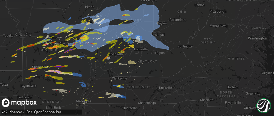
Hail Map in Kentucky on April 27, 2026
The weather event in Kentucky on April 27, 2026 includes Hail, Wind, and Tornado maps. 15 states and 2,084 cities were impacted and suffered possible damage. The total estimated number of properties impacted is 4,422.
Hail
Wind
Tornado
4,422
Estimated number of impacted properties by a 1.00" hail or larger0
Estimated number of impacted properties by a 1.75" hail or larger0
Estimated number of impacted properties by a 2.50" hail or largerStorm reports in Kentucky
Kentucky
| Date | Description |
|---|---|
| 04/27/20266:56 PM CDT | Trees down in smithfield. Time estimated from radar. |
| 04/27/20266:50 PM CDT | Several trees down and a few uprooted in the crystal lake subdivision. |
| 04/27/20266:43 PM CDT | Several trees snapped on highpoint drive. |
| 04/27/20266:38 PM CDT | Tree down on residential structure. |
| 04/27/20261:10 PM CDT | A local report indicates 1.00 inch wind near 2 WSW Owensboro |
| 04/27/202612:50 PM CDT | A local report indicates 1.00 inch wind near 2 SSE Sebree |
| 04/27/202612:49 PM CDT | A local report indicates 1.00 inch wind near 7 E Sebree |
| 04/27/20262:59 AM CDT | Tree down on phoneline along lakeview ave. |
| 04/27/20262:37 AM CDT | Trees down blocking most of the roadway. |
| 04/27/20262:37 AM CDT | Tree down blocking the road; akersville and ridge top road. |
| 04/27/20262:23 AM CDT | Tree blocking roadway. |
| 04/27/20262:21 AM CDT | Large tree down in roadway; cumberland parkway. |
| 04/27/20262:20 AM CDT | Social media user reports downed tree at intersection of ky 1110 and ky 397. Time estimated by radar. |
| 04/27/20262:17 AM CDT | Tree down near happy church in jackson. |
| 04/27/20262:14 AM CDT | Tree down in road in front of harmon furniture blocking all of the road. |
| 04/27/20262:12 AM CDT | Power lines leaning up against a tree. |
| 04/27/20262:10 AM CDT | Tree down blocking the entire roadway. On lemon bend rd after antle ln and before stubbs rd. |
| 04/27/20262:10 AM CDT | Large tree branches had fallen and patio furniture was blown over. |
| 04/27/20262:07 AM CDT | Two trees were reported down on cave branch road near bethany. The event time is radar estimated. |
| 04/27/20262:07 AM CDT | Electric pole down; hwy 68 and matney rd. |
| 04/27/20262:07 AM CDT | Tree down in roadway; whitewood rd. |
| 04/27/20262:03 AM CDT | Residential tree damage: split trees and limb damage. |
| 04/27/20261:57 AM CDT | Tree down in roadway; new salem road. |
| 04/27/20261:56 AM CDT | The morgan county road department reported a tree down across new cummer road near the intersection of upper long branch road. |
| 04/27/20261:55 AM CDT | A few trees down next to olive hill on state route 174. Power lines were down as well. Time estimated by radar. |
| 04/27/20261:35 AM CDT | Trees down; frenchman knob rb and locust grove rd. |
| 04/27/20261:33 AM CDT | The montgomery county garage reported a several inch diameter limb down on lower spruce road about halfway between ky-1050 and ky-599. |
| 04/27/20261:28 AM CDT | The montgomery county road department reported a 12 inch limb down on reffitt road close to the intersection of ky-213. |
| 04/27/20261:27 AM CDT | Trees down along rawlings rd. Time estimated by radar. |
| 04/27/20261:27 AM CDT | Tree down along anderson branch rd. Time estimated by radar. |
| 04/27/20261:20 AM CDT | The montgomery road department reported an 18 inch limb down on quisenberry road about a 1000 feet from the intersection of us-60. |
| 04/27/20261:09 AM CDT | 3 large trees snapped along bownman mill road. |
| 04/27/20261:04 AM CDT | Large trees snapped and uprooted in the midway cemetery. |
| 04/27/202612:49 AM CDT | Roof damage |
| 04/27/202612:49 AM CDT | Damaged outdoor furniture and several trees down. Trash cans blown upside down. |
| 04/27/202612:45 AM CDT | Trailer sitting on concrete blocks tipped over. Time estimated from radar. |
| 04/27/202612:43 AM CDT | Large tree limbs down in mortons gap. |
| 04/27/202612:39 AM CDT | Multiple trees and utility lines knocked down. Time est from radar. |
| 04/27/202612:35 AM CDT | Power lines and trees down along crab tree alley. |
| 04/27/202612:35 AM CDT | Power lines and trees down along hamlin chapel rd. |
| 04/27/202612:35 AM CDT | Power lines and trees down near walnut and clay streets. |
| 04/27/202612:30 AM CDT | A national weather service storm survey confirmed an ef1 tornado touched down north of hartford during the early morning hours on april 28th. The maximum estimated wind |
| 04/27/202612:23 AM CDT | Multiple trees down. Time est from radar. |
| 04/27/202612:15 AM CDT | Power lines down on steedland drive. |
| 04/27/202612:14 AM CDT | Tree down and roof off of building. |
| 04/27/202612:14 AM CDT | Several trees uprooted north of livermore on 431 between atherton and 1080. |
| 04/27/202612:13 AM CDT | Building damage... Detached garage collapsed... Metal in field. |
| 04/27/202612:06 AM CDT | K8gk awos. |
| 04/27/202612:01 AM CDT | Tree damage on residential property off of hinkle lane. |
| 04/26/202611:59 PM CDT | Damage along ky 370 near ashbyburg. A few homes with roof damage... Large trees down... Electrical transmission lines down. Time estimated from radar. |
| 04/26/202611:56 PM CDT | Ef-0 tornado with peak winds of 85 mph. Trees were snapped and rooted and numerous large limbs were downed. Two electrical transmission line cross members were broken. |
| 04/26/202611:55 PM CDT | Trees down along ky 370 at the hopkins-webster county line. Time estimated from radar. |
| 04/26/202611:50 PM CDT | Measured at the oldham county kentucky mesonet station. |
| 04/26/202611:46 PM CDT | Tree across the roadway on state route 271 s. |
| 04/26/202611:40 PM CDT | Trees down on both hawkins and taylor. Time estimated from radar. |
| 04/26/202611:40 PM CDT | Tree down across the roadway. |
| 04/26/202611:38 PM CDT | Trees down on 2300 block of us42. Time estimated from radar. |
| 04/26/202611:35 PM CDT | Trees down on alves st. Time estimated from radar. |
| 04/26/202610:20 PM CDT | Trimble county mesonet. |
| 04/26/20268:02 PM CDT | Time estimated by radar. |
| 04/26/20267:10 PM CDT | Pictures of barn destroyed as well as bent power poles. |
All States Impacted by Hail Map on April 27, 2026
Cities Impacted by Hail Map on April 27, 2026
- Hoyleton, IL
- Centralia, IL
- Carlyle, IL
- Jonesboro, IL
- Hoffman, IL
- Macon, MO
- Excello, MO
- McLeansboro, IL
- Macedonia, IL
- Cobden, IL
- Anna, IL
- Dongola, IL
- Edwardsville, IL
- Worden, IL
- Moro, IL
- Brunswick, MO
- Makanda, IL
- Dalton, MO
- Charleston, MO
- East Prairie, MO
- Palmyra, IL
- Carlinville, IL
- Hettick, IL
- Greenfield, IL
- Sandoval, IL
- Buncombe, IL
- Bunker Hill, IL
- Staunton, IL
- Goreville, IL
- Anabel, MO
- Keytesville, MO
- Salisbury, MO
- New Douglas, IL
- Ozark, IL
- Vienna, IL
- Clarence, MO
- Novelty, MO
- Dorsey, IL
- Livingston, IL
- Odin, IL
- Cairo, MO
- Huntsville, MO
- Modesto, IL
- Clifton Hill, MO
- Girard, IL
- Creal Springs, IL
- Simpson, IL
- New Burnside, IL
- Moberly, MO
- Marion, IL
- Mount Olive, IL
- Walshville, IL
- Litchfield, IL
- Knox City, MO
- Shelbyville, MO
- Bethel, MO
- Edina, MO
- Leonard, MO
- Newark, MO
- Jacksonville, MO
- Slater, MO
- Malta Bend, MO
- Carrollton, MO
- Gilliam, MO
- Triplett, MO
- Bosworth, MO
- Marshall, MO
- De Witt, MO
- Miami, MO
- Glasgow, MO
- Mendon, MO
- Clark, MO
- Lentner, MO
- Shelbina, MO
- Callao, MO
- Armstrong, MO
- Bevier, MO
- Higbee, MO
- Harrisburg, MO
- Madison, MO
- Fayette, MO
- Marceline, MO
- New Cambria, MO
- Sturgeon, MO
- Paris, MO
- Holliday, MO
- Chesterfield, IL
- Medora, IL
- Jerseyville, IL
- Rockbridge, IL
- La Belle, MO
- Roodhouse, IL
- Virden, IL
- Burfordville, MO
- Jackson, MO
- Whitewater, MO
- Hunnewell, MO
- Centralia, MO
- Mexico, MO
- Emden, MO
- Thompson, MO
- Stoutsville, MO
- Santa Fe, MO
- Columbia, MO
- Hallsville, MO
- Broughton, IL
- Enfield, IL
- Loami, IL
- Waverly, IL
- Monroe City, MO
- Oak Ridge, MO
- Altenburg, MO
- Center, MO
- Laddonia, MO
- Philadelphia, MO
- Palmyra, MO
- Perry, MO
- Rush Hill, MO
- Farber, MO
- Grand Tower, IL
- Auburn, IL
- Hannibal, MO
- Vandalia, MO
- New London, MO
- Frohna, MO
- New Berlin, IL
- Wolf Lake, IL
- Murrayville, IL
- Curryville, MO
- Frankford, MO
- Gorham, IL
- Murphysboro, IL
- Tipton, MO
- Nokomis, IL
- Morrisonville, IL
- Carbondale, IL
- Pomona, IL
- Pinckneyville, IL
- Coulterville, IL
- Auxvasse, MO
- Chatham, IL
- McClure, IL
- Thebes, IL
- Tamms, IL
- Kinderhook, IL
- Hull, IL
- New Canton, IL
- Ashburn, MO
- Barry, IL
- Louisiana, MO
- Rockport, IL
- Bowling Green, MO
- Glenarm, IL
- Mulkeytown, IL
- Royalton, IL
- Elkville, IL
- De Soto, IL
- Springfield, IL
- Owaneco, IL
- West Frankfort, IL
- Taylorville, IL
- Benton, IL
- Christopher, IL
- Clarksville, MO
- Pleasant Hill, IL
- Griggsville, IL
- Pittsfield, IL
- Nebo, IL
- New Salem, IL
- Assumption, IL
- Rochester, IL
- Scheller, IL
- Sesser, IL
- Baylis, IL
- Waltonville, IL
- Orient, IL
- Mechanicsburg, IL
- Dawson, IL
- Ashley, IL
- Milton, IL
- Pearl, IL
- Hillview, IL
- Pawnee, IL
- Riverton, IL
- Woodlawn, IL
- Thompsonville, IL
- Logan, IL
- Mount Vernon, IL
- Winchester, IL
- Bluffs, IL
- Pleasant Plains, IL
- Athens, IL
- Sherman, IL
- Williamsville, IL
- Pittsburg, IL
- White Hall, IL
- Ashland, IL
- Alexander, IL
- Niantic, IL
- Illiopolis, IL
- Buffalo, IL
- Kampsville, IL
- Johnston City, IL
- Stonefort, IL
- Carrier Mills, IL
- Grantsburg, IL
- Warrensburg, IL
- Petersburg, IL
- Tallula, IL
- Golconda, IL
- Decatur, IL
- Mount Pulaski, IL
- Latham, IL
- Maroa, IL
- Dahlgren, IL
- Ewing, IL
- Galatia, IL
- Harrisburg, IL
- Franklin, IL
- Patterson, IL
- Woodson, IL
- Jacksonville, IL
- Carterville, IL
- Eddyville, IL
- Wrights, IL
- Herod, IL
- Greenview, IL
- Eldorado, IL
- Ingraham, IL
- Clay City, IL
- Dale, IL
- Equality, IL
- Norris City, IL
- Noble, IL
- Omaha, IL
- Cantrall, IL
- Wayne City, IL
- Argenta, IL
- Springerton, IL
- Fidelity, IL
- Junction, IL
- Ridgway, IL
- Bulpitt, IL
- Divernon, IL
- Edinburg, IL
- Waggoner, IL
- Tovey, IL
- Mount Auburn, IL
- Kincaid, IL
- Harvel, IL
- Farmersville, IL
- Thayer, IL
- Fairfield, IL
- Barnhill, IL
- Weldon, IL
- New Haven, IL
- Golden Gate, IL
- Hillsboro, IL
- Raleigh, IL
- Butler, IL
- Irving, IL
- Centertown, MO
- Witt, IL
- Carmi, IL
- Mount Vernon, IN
- Taylor Springs, IL
- Palmer, IL
- Olney, IL
- Fillmore, IL
- Pana, IL
- De Land, IL
- Bingham, IL
- New Harmony, IN
- Shawneetown, IL
- Lakewood, IL
- Tuscola, IL
- Stewardson, IL
- Boody, IL
- Moweaqua, IL
- Macon, IL
- Sadorus, IL
- La Place, IL
- Tolono, IL
- Dalton City, IL
- Mt Zion, IL
- Sullivan, IL
- Arcola, IL
- Strasburg, IL
- Blue Mound, IL
- Bement, IL
- Lovington, IL
- Pesotum, IL
- Tower Hill, IL
- Shelbyville, IL
- Findlay, IL
- Mode, IL
- Gays, IL
- Atwood, IL
- Hammond, IL
- Bethany, IL
- Rosamond, IL
- Arthur, IL
- Stonington, IL
- Windsor, IL
- Ivesdale, IL
- Cerro Gordo, IL
- Beecher City, IL
- Wadesville, IN
- Poseyville, IN
- Ramsey, IL
- Claremont, IL
- Donnellson, IL
- Mulberry Grove, IL
- Greenville, IL
- Sumner, IL
- Evansville, IN
- Cynthiana, IN
- Fredonia, KY
- Marion, KY
- Brownstown, IL
- Tebbetts, MO
- Mokane, MO
- Steedman, MO
- Fulton, MO
- Uniontown, KY
- Henderson, KY
- Corydon, KY
- Newburgh, IN
- Providence, KY
- Princeton, KY
- Saint Peters, MO
- Saint Charles, MO
- Saint Elmo, IL
- Chandler, IN
- Smithboro, IL
- Clay, KY
- Cowden, IL
- Sebree, KY
- Nebo, KY
- Slaughters, KY
- Dixon, KY
- Boonville, IN
- Sigel, IL
- Neoga, IL
- Hindsboro, IL
- Lerna, IL
- Philo, IL
- Camargo, IL
- Toledo, IL
- Sidney, IL
- Villa Grove, IL
- Trilla, IL
- Longview, IL
- Charleston, IL
- Mattoon, IL
- Humboldt, IL
- Manitou, KY
- Vandalia, IL
- Decker, IN
- Hazleton, IN
- Effingham, IL
- Earth City, MO
- Hazelwood, MO
- Bridgeton, MO
- Patoka, IN
- Montrose, IL
- Altamont, IL
- Oakland City, IN
- Francisco, IN
- Owensboro, KY
- Calhoun, KY
- Saint Ann, MO
- Saint Louis, MO
- Maryland Heights, MO
- Chesterfield, MO
- Florissant, MO
- Tennyson, IN
- Princeton, IN
- Monroe City, IN
- Westfield, IL
- Kansas, IL
- Casey, IL
- Ashmore, IL
- Vincennes, IN
- Martinsville, IL
- Marshall, IL
- Gentryville, IN
- Washington, IN
- Wheatland, IN
- Lincoln City, IN
- Chrisney, IN
- Santa Claus, IN
- Lamar, IN
- Dale, IN
- Newton, IL
- Evanston, IN
- Holland, IN
- West Union, IL
- West Liberty, IL
- Willow Hill, IL
- Augusta, MO
- Defiance, MO
- Labadie, MO
- Huntingburg, IN
- Terre Haute, IN
- Kincaid, KS
- Wildwood, MO
- Rockport, IN
- Ballwin, MO
- Salem, IL
- Loogootee, IN
- Saint Anthony, IN
- Ferdinand, IN
- Birdseye, IN
- Centerville, KS
- Blue Mound, KS
- Fairbanks, IN
- Farmersburg, IN
- West York, IL
- Farina, IL
- Kinmundy, IL
- Xenia, IL
- Parker, KS
- Mound City, KS
- Celestine, IN
- Schnellville, IN
- Taswell, IN
- Eckerty, IN
- Pleasanton, KS
- Sullivan, IN
- Jasonville, IN
- Louisville, IL
- Hermann, MO
- New Florence, MO
- Shoals, IN
- Mitchell, IN
- Bedford, IN
- Williams, IN
- Worthington, IN
- Clay City, IN
- Coal City, IN
- Freedom, IN
- La Cygne, KS
- Amoret, MO
- Adrian, MO
- Amsterdam, MO
- Butler, MO
- La Harpe, KS
- Moran, KS
- Bronson, KS
- South Roxana, IL
- Roxana, IL
- Hartford, IL
- Wood River, IL
- Dundas, IL
- Sailor Springs, IL
- Granite City, IL
- High Hill, MO
- Jonesburg, MO
- Rhineland, MO
- Truxton, MO
- Bethalto, IL
- Humboldt, KS
- Linton, IN
- Iola, KS
- Glen Carbon, IL
- Paoli, IN
- English, IN
- Marengo, IN
- Madison, IL
- Warrenton, MO
- Alhambra, IL
- Grafton, IL
- Bicknell, IN
- Rinard, IL
- Maryville, IL
- Collinsville, IL
- Edwardsport, IN
- Flora, IL
- Portage Des Sioux, MO
- Brussels, IL
- Golden Eagle, IL
- O'Fallon, MO
- Troy, IL
- Marine, IL
- Garden City, MO
- Drexel, MO
- Bloomington, IN
- Solsberry, IN
- Springville, IN
- Avoca, IN
- Oolitic, IN
- Troy, MO
- Wright City, MO
- Urich, MO
- Creighton, MO
- Carlisle, IN
- Blairstown, MO
- Chilhowee, MO
- Mapleton, KS
- Wesley, IA
- Montrose, MO
- Sorento, IL
- Hawk Point, MO
- Foristell, MO
- Clinton, MO
- Moscow Mills, MO
- Highland, IL
- Spencer, IN
- Nashville, IN
- Mount Erie, IL
- Lake Saint Louis, MO
- Wentzville, MO
- Lyons, IN
- Elnora, IN
- Newberry, IN
- Prescott, KS
- Fulton, KS
- Odon, IN
- Wooldridge, MO
- Prairie Home, MO
- Centerview, MO
- Jamestown, MO
- Switz City, IN
- Chanute, KS
- Elsmore, KS
- Odessa, MO
- Holden, MO
- Foster, MO
- Windsor, MO
- Leeton, MO
- Calhoun, MO
- Rocheport, MO
- Heltonville, IN
- Bloomfield, IN
- Norman, IN
- Crane, IN
- Concordia, MO
- Old Monroe, MO
- Rich Hill, MO
- Uniontown, KS
- Hume, MO
- Ellery, IL
- Albion, IL
- Calhoun, IL
- Parkersburg, IL
- Warrensburg, MO
- Green Ridge, MO
- Sweet Springs, MO
- West Salem, IL
- Boonville, MO
- Pilot Grove, MO
- Bridgeport, IL
- Montgomery, IN
- Lawrenceville, IL
- Flat Rock, IL
- Owensburg, IN
- Sedalia, MO
- Plainville, IN
- Bunceton, MO
- Fredonia, KS
- Smithton, MO
- Otterville, MO
- Syracuse, MO
- Florence, MO
- Brownstown, IN
- Freetown, IN
- Dow, IL
- Seymour, IN
- La Monte, MO
- Salem, IN
- Godfrey, IL
- Brighton, IL
- Saint Francisville, IL
- Houstonia, MO
- Nelson, MO
- Knob Noster, MO
- Diamond, MO
- Neosho, MO
- Joplin, MO
- Alton, IL
- West Alton, MO
- Elsah, IL
- Campbellsburg, IN
- Vallonia, IN
- Thayer, KS
- Fortuna, MO
- New Franklin, MO
- Scotland, IN
- West Baden Springs, IN
- Orleans, IN
- North Vernon, IN
- Austin, IN
- Scipio, IN
- Paris Crossing, IN
- Columbus, IN
- Crothersville, IN
- Commiskey, IN
- Deputy, IN
- Sarcoxie, MO
- Pierce City, MO
- Wentworth, MO
- Stotts City, MO
- Payson, IL
- Quincy, IL
- Mora, MO
- Cole Camp, MO
- Stover, MO
- Cottage Hills, IL
- Alta Vista, IA
- Granby, MO
- Benton City, MO
- Clarksburg, MO
- Wellsville, MO
- Osceola, MO
- Scottsburg, IN
- Franklin, MO
- Versailles, MO
- Martinsburg, MO
- California, MO
- Bone Gap, IL
- Galesburg, KS
- Saint Paul, KS
- Erie, KS
- Mount Vernon, MO
- Otwell, IN
- Mount Carmel, IL
- Allendale, IL
- Elma, IA
- Petersburg, IN
- Oblong, IL
- Ragsdale, IN
- Quincy, MO
- Latham, MO
- Camp Point, IL
- Aurora, MO
- Marionville, MO
- Billings, MO
- Ash Grove, MO
- Golden, IL
- Chambersburg, IL
- Perry, IL
- Barnett, MO
- Russellville, MO
- Noel, MO
- Kingdom City, MO
- New Hampton, IA
- Cresco, IA
- Shelburn, IN
- Monett, MO
- Clayton, IL
- Stark City, MO
- Browns, IL
- Republic, MO
- Jefferson City, MO
- Hartsburg, MO
- Everton, MO
- Cannelburg, IN
- Pineville, MO
- Ashland, MO
- Montgomery City, MO
- Williamsburg, MO
- Verona, MO
- Eldred, IL
- Gravette, AR
- Sulphur Springs, AR
- Jasper, IN
- Meredosia, IL
- Freistatt, MO
- Lohman, MO
- Gravois Mills, MO
- Eldon, MO
- Rocky Mount, MO
- Middletown, MO
- Brookline, MO
- Springfield, MO
- Rogersville, MO
- Buffalo, MO
- Elkland, MO
- Long Lane, MO
- Phillipsburg, MO
- Bella Vista, AR
- Walnut Grove, MO
- Willard, MO
- Teutopolis, IL
- Powell, MO
- Washburn, MO
- Purdy, MO
- San Jose, IL
- Atkins, IA
- Newhall, IA
- Ridgeway, IA
- Decorah, IA
- Huntsville, IL
- La Prairie, IL
- Dubois, IN
- Annada, MO
- Mason City, IL
- Beardstown, IL
- Arenzville, IL
- Tuscumbia, MO
- Eugene, MO
- Henley, MO
- Pea Ridge, AR
- Seligman, MO
- Virginia, IL
- Exeter, MO
- Cassville, MO
- Crane, MO
- Strafford, MO
- Fordland, MO
- Winfield, MO
- Foley, MO
- Olean, MO
- Nixa, MO
- Ozark, MO
- French Lick, IN
- Lebanon, MO
- Palo, IA
- Cedar Rapids, IA
- Silex, MO
- Pendleton, KY
- Bedford, KY
- Hiawatha, IA
- Shellsburg, IA
- Burnt Prairie, IL
- Grayville, IL
- Crossville, IL
- Mill Shoals, IL
- Saint Thomas, MO
- Batchtown, IL
- Dieterich, IL
- Chapin, IL
- New Bloomfield, MO
- Fairview, MO
- Stoutland, MO
- Montreal, MO
- Richland, MO
- Saint Elizabeth, MO
- Westphalia, MO
- Freeburg, MO
- Koeltztown, MO
- Meta, MO
- Holts Summit, MO
- Robins, IA
- Marion, IA
- Clever, MO
- Mackinaw, IL
- Tremont, IL
- Hopedale, IL
- Carrollton, IL
- Hardin, IL
- Fieldon, IL
- Eolia, MO
- Elsberry, MO
- Morton, IL
- Loose Creek, MO
- Hardinsburg, IN
- Milltown, IN
- Winslow, IN
- Bellmont, IL
- Seymour, MO
- Crocker, MO
- Bonnots Mill, MO
- Linn, MO
- Chamois, MO
- Bland, MO
- Argyle, MO
- Belle, MO
- Kane, IL
- Elkhart, IL
- Bellflower, MO
- Saint James, MO
- Cuba, MO
- Palmyra, IN
- Springville, IA
- Pekin, IN
- Depauw, IN
- Fredericksburg, IN
- Hamburg, IL
- Conway, MO
- Hartville, MO
- Mansfield, MO
- Marshfield, MO
- Dixon, MO
- Mount Sterling, MO
- Morrison, MO
- Owensville, MO
- Piasa, IL
- Shipman, IL
- Vichy, MO
- Truesdale, MO
- Bourbon, MO
- Leasburg, MO
- Laquey, MO
- Vienna, MO
- Velpen, IN
- Stendal, IN
- Rolla, MO
- Middletown, IL
- Oaktown, IN
- Marthasville, MO
- Mountain Grove, MO
- Norwood, MO
- Sullivan, MO
- Rosebud, MO
- Gerald, MO
- Leslie, MO
- New Haven, MO
- Chandlerville, IL
- Oakford, IL
- Lincoln, IL
- Sparta, MO
- Ava, MO
- Milmine, IL
- New Holland, IL
- Owensville, IN
- Chestnut, IL
- Beason, IL
- Bruner, MO
- Berger, MO
- Ponce De Leon, MO
- Highlandville, MO
- Galena, MO
- Clinton, IL
- Kenney, IL
- Saint Clair, MO
- Villa Ridge, MO
- Union, MO
- Robertsville, MO
- Harristown, IL
- Downs, IL
- Wapella, IL
- Waynesville, IL
- Le Roy, IL
- Atlanta, IL
- Heyworth, IL
- McLean, IL
- Catawissa, MO
- Pacific, MO
- Gray Summit, MO
- Eureka, MO
- Cabool, MO
- Graff, MO
- Monticello, IL
- Washington, MO
- Garfield, AR
- Beaufort, MO
- Farmersville, TX
- Shell Knob, MO
- Gillespie, IL
- Raymond, IL
- Edgar Springs, MO
- Reeds Spring, MO
- Rogers, AR
- Salem, MO
- Cape Fair, MO
- Lonedell, MO
- Dittmer, MO
- Grubville, MO
- Richwoods, MO
- Luebbering, MO
- Elk Creek, MO
- Houston, MO
- Solo, MO
- Drury, MO
- Hillsboro, MO
- Cook Sta, MO
- Rosedale, IN
- Clinton, IN
- Branson, MO
- Nilwood, IL
- Grand Prairie, TX
- Dallas, TX
- Irving, TX
- East Alton, IL
- Yukon, MO
- Summersville, MO
- Raymondville, MO
- Eunice, MO
- Oldfield, MO
- Montezuma, IN
- Rockville, IN
- White Heath, IL
- Vanzant, MO
- Dora, MO
- Crescent City, IL
- Arrowsmith, IL
- Farmer City, IL
- Onarga, IL
- Loda, IL
- Mahomet, IL
- Gibson City, IL
- Oreana, IL
- Saybrook, IL
- Mansfield, IL
- Forsyth, IL
- Cisco, IL
- Sibley, IL
- Buckley, IL
- Bellflower, IL
- Fisher, IL
- Foosland, IL
- Paxton, IL
- Roberts, IL
- Melvin, IL
- Elliott, IL
- Dewitt, IL
- Lane, IL
- Saunemin, IL
- Cullom, IL
- Ellsworth, IL
- Cropsey, IL
- Colfax, IL
- Forrest, IL
- Fairbury, IL
- Chenoa, IL
- Cooksville, IL
- Bloomington, IL
- Towanda, IL
- Lexington, IL
- Pontiac, IL
- Gridley, IL
- Normal, IL
- Anchor, IL
- Strawn, IL
- Chatsworth, IL
- Fenton, MO
- High Ridge, MO
- Saint Albans, MO
- Valley Park, MO
- Seymour, IL
- Hartshorn, MO
- Willow Springs, MO
- Celeste, TX
- Macomb, MO
- Rockaway Beach, MO
- Powersite, MO
- Forsyth, MO
- Kirbyville, MO
- Kissee Mills, MO
- Griffin, IN
- Taneyville, MO
- Rowlett, TX
- Richardson, TX
- Bradleyville, MO
- Rueter, MO
- Thornfield, MO
- Theodosia, MO
- Steelville, MO
- Barnhart, MO
- Imperial, MO
- Cedar Hill, MO
- Arnold, MO
- House Springs, MO
- Pevely, MO
- Garland, TX
- Bruceville, IN
- Grantsburg, IN
- Greenville, TX
- Dundee, MS
- Crenshaw, MS
- Sarah, MS
- Cherryville, MO
- Davisville, MO
- Hamel, IL
- Pomona, MO
- Mountain View, MO
- Plano, TX
- Noble, MO
- Wasola, MO
- Gainesville, MO
- Mesquite, TX
- Eminence, MO
- Potosi, MO
- Sachse, TX
- Roachdale, IN
- Russellville, IN
- Isabella, MO
- Wilsonville, IL
- Pocahontas, IL
- Urbana, IL
- Champaign, IL
- Valmeyer, IL
- Oconee, IL
- Wolfe City, TX
- Waterloo, IL
- Columbia, IL
- Millstadt, IL
- East Saint Louis, IL
- East Carondelet, IL
- Dupo, IL
- Herculaneum, MO
- Wylie, TX
- Allen, TX
- Princeton, TX
- Benld, IL
- Sawyerville, IL
- Ladoga, IN
- Viburnum, MO
- Thomasboro, IL
- Piper City, IL
- Rantoul, IL
- Dewey, IL
- Watseka, IL
- Cissna Park, IL
- Gilman, IL
- Gifford, IL
- Rankin, IL
- Thawville, IL
- Ludlow, IL
- Milford, IL
- Bondville, IL
- Potomac, IL
- Newman, IL
- Saint Joseph, IL
- Penfield, IL
- Broadlands, IL
- Savoy, IL
- Ogden, IL
- Royal, IL
- Homer, IL
- Armstrong, IL
- Herrick, IL
- Lovejoy, IL
- Venice, IL
- Belleville, IL
- New Athens, IL
- Smithton, IL
- O'Fallon, IL
- Freeburg, IL
- Fairview Heights, IL
- New Ross, IN
- Commerce, TX
- Coffeen, IL
- De Soto, MO
- Festus, MO
- Panama, IL
- Calhan, CO
- Belgrade, MO
- Pontiac, MO
- Collison, IL
- Hoopeston, IL
- Stockland, IL
- Brook, IN
- Donovan, IL
- Fithian, IL
- Sheldon, IL
- Wellington, IL
- Kentland, IN
- Rossville, IL
- Earl Park, IN
- West Plains, MO
- Hardenville, MO
- Udall, MO
- Caulfield, MO
- Tecumseh, MO
- Rockwall, TX
- Red Bud, IL
- Hecker, IL
- Trenton, IL
- Klondike, TX
- Royse City, TX
- Saint Jacob, IL
- New Baden, IL
- Scott Air Force Base, IL
- Albers, IL
- Aviston, IL
- Mascoutah, IL
- Summerfield, IL
- Breese, IL
- Germantown, IL
- Lebanon, IL
- Bartelso, IL
- Shumway, IL
- Keyesport, IL
- Lenzburg, IL
- Indianola, IL
- Oakwood, IL
- Fairmount, IL
- Allerton, IL
- Zanoni, MO
- Crystal City, MO
- Irondale, MO
- Caledonia, MO
- Cumby, TX
- Peace Valley, MO
- Birch Tree, MO
- Moody, MO
- Pottersville, MO
- Bakersfield, MO
- Ohlman, IL
- Saint Libory, IL
- Marissa, IL
- Oakdale, IL
- Nashville, IL
- Addieville, IL
- Blue Ridge, TX
- Leonard, TX
- Caseyville, IL
- Alton, MO
- Gepp, AR
- Otterbein, IN
- Boswell, IN
- Pine Village, IN
- Templeton, IN
- Catlin, IL
- Covington, IN
- Goodland, IN
- Muncie, IL
- Tilton, IL
- Henning, IL
- West Lebanon, IN
- West Lafayette, IN
- Bismarck, IL
- Ambia, IN
- State Line, IN
- Danville, IL
- Remington, IN
- Fowler, IN
- Williamsport, IN
- Westville, IL
- Brookston, IN
- Oxford, IN
- Attica, IN
- Alvin, IL
- Viola, AR
- Wolcott, IN
- Westpoint, IN
- Metcalf, IL
- Sidell, IL
- Ridge Farm, IL
- Georgetown, IL
- Perrysville, IN
- Hume, IL
- Veedersburg, IN
- Lafayette, IN
- Okawville, IL
- Beckemeyer, IL
- Patoka, IL
- Vernon, IL
- Shobonier, IL
- Koshkonong, MO
- Sturkie, AR
- Fremont, MO
- Winona, MO
- Quinlan, TX
- Terrell, TX
- Newtown, IN
- Wingate, IN
- Park Hills, MO
- Doe Run, MO
- Farmington, MO
- New Richmond, IN
- Romney, IN
- Chrisman, IL
- Bloomingdale, IN
- Kingman, IN
- Hillsboro, IN
- Mellott, IN
- Cayuga, IN
- Dana, IN
- Sulphur Springs, TX
- Bismarck, MO
- Mineral Point, MO
- Leadwood, MO
- Bonne Terre, MO
- Greenup, IL
- Jewett, IL
- Merrimac, WI
- Saint Peter, IL
- Ellington, MO
- Alma, IL
- Tilden, IL
- Sparta, IL
- Baldwin, IL
- Edgewood, IL
- Mason, IL
- Watson, IL
- Brocton, IL
- Richview, IL
- Oakland, IL
- Fults, IL
- Gamaliel, AR
- Dike, TX
- Ladonia, TX
- Crawfordsville, IN
- Waynetown, IN
- Rossville, IN
- Dayton, IN
- Delphi, IN
- Mulberry, IN
- Paris, IL
- Clarks Hill, IN
- New Market, IN
- Darlington, IN
- Alamo, IN
- Linden, IN
- Wheeler, IL
- Walnut Hill, IL
- Iuka, IL
- Hidalgo, IL
- Dix, IL
- Texico, IL
- Kell, IL
- Yale, IL
- Sainte Marie, IL
- Johnsonville, IL
- Irvington, IL
- Sainte Genevieve, MO
- Doniphan, MO
- Van Buren, MO
- Salem, AR
- Du Bois, IL
- Tamaroa, IL
- Bonham, TX
- Prairie Du Rocher, IL
- Lone Oak, TX
- Point, TX
- Sulphur Bluff, TX
- Saltillo, TX
- Frankfort, IN
- Colfax, IN
- Mount Vernon, TX
- Thorntown, IN
- Camp, AR
- Mammoth Spring, AR
- Thayer, MO
- Grandin, MO
- Saint Mary, MO
- Honey Grove, TX
- Emory, TX
- Rio, WI
- Poynette, WI
- Pardeeville, WI
- Greenville, IN
- Wills Point, TX
- Sunnyvale, TX
- Nevada, TX
- Portage, WI
- Baraboo, WI
- Mountain Home, AR
- Ironton, MO
- West Terre Haute, IN
- Dennison, IL
- Vermilion, IL
- New Goshen, IN
- Annapolis, IL
- Waterford, MS
- Potts Camp, MS
- Clarkridge, AR
- Hickory Flat, MS
- Kokomo, IN
- Cutler, IN
- Russiaville, IN
- Forest, IN
- Michigantown, IN
- Sharpsville, IN
- Jamestown, IN
- Kempton, IN
- Kirklin, IN
- Lebanon, IN
- Advance, IN
- Mecca, IN
- Universal, IN
- Perryville, MO
- Du Quoin, IL
- Bonnie, IL
- Keenes, IL
- Bluford, IL
- Dane, WI
- Cambria, WI
- Ravenden, AR
- Bloomsdale, MO
- Cutler, IL
- Brazil, IN
- Fredericktown, MO
- Patterson, MO
- Sims, IL
- Elizabeth, AR
- Myrtle, MS
- Amboy, IN
- Bunker Hill, IN
- Converse, IN
- Greentown, IN
- Blue Mountain, MS
- Waunakee, WI
- Deforest, WI
- Calico Rock, AR
- Geff, IL
- Cisne, IL
- Piedmont, MO
- Pocahontas, AR
- Belle Rive, IL
- Opdyke, IL
- Campbell, TX
- Wabash, IN
- Greenville, MO
- Silva, MO
- Marshall, AR
- Rockwood, IL
- Jacob, IL
- Ava, IL
- Greencastle, IN
- Cory, IN
- Putnamville, IN
- Centerpoint, IN
- Carbon, IN
- Staunton, IN
- Harmony, IN
- Pimento, IN
- Bridgeton, IN
- Robinson, IL
- Knightsville, IN
- Danville, IN
- Amo, IN
- Stoy, IL
- Cloverdale, IN
- Poland, IN
- Bainbridge, IN
- Coatesville, IN
- Palestine, IL
- Fillmore, IN
- Riley, IN
- Reelsville, IN
- Hutsonville, IL
- Merom, IN
- Lewis, IN
- Dolph, AR
- Bexar, AR
- Wideman, AR
- Oxford, AR
- Fairdealing, MO
- Poplar Bluff, MO
- Harviell, MO
- Windfall, IN
- Tipton, IN
- Frankton, IN
- Summitville, IN
- Whitestown, IN
- La Fontaine, IN
- Goldsmith, IN
- Atlanta, IN
- Marion, IN
- Jonesboro, IN
- Fairmount, IN
- Cicero, IN
- Alexandria, IN
- Sweetser, IN
- Arcadia, IN
- Sheridan, IN
- Elwood, IN
- Swayzee, IN
- Westfield, IN
- Noblesville, IN
- Zionsville, IN
- Gaston, IN
- Fowlerton, IN
- Gas City, IN
- Springport, IN
- Muncie, IN
- Warren, IN
- Carmel, IN
- Pendleton, IN
- Lapel, IN
- Lagro, IN
- Matthews, IN
- Shirley, IN
- Van Buren, IN
- Huntington, IN
- Yorktown, IN
- Andrews, IN
- Markleville, IN
- Indianapolis, IN
- Fortville, IN
- Fishers, IN
- Mccordsville, IN
- Middletown, IN
- Upland, IN
- Daleville, IN
- Anderson, IN
- Whittington, IL
- Ina, IL
- Camby, IN
- Gosport, IN
- Stilesville, IN
- Monrovia, IN
- Quincy, IN
- Avon, IN
- Bowling Green, IN
- West Newton, IN
- Hymera, IN
- Patricksburg, IN
- Plainfield, IN
- Clayton, IN
- Brooklyn, IN
- Martinsville, IN
- Ellettsville, IN
- Paragon, IN
- Freelandville, IN
- Mooresville, IN
- Coalmont, IN
- Sandborn, IN
- Dugger, IN
- Ash Flat, AR
- Glencoe, AR
- Horseshoe Bend, AR
- Wiseman, AR
- Neelyville, MO
- Secor, IL
- Congerville, IL
- Eureka, IL
- Goodfield, IL
- Carlock, IL
- Metamora, IL
- Warm Springs, AR
- Cherokee Village, AR
- Hardy, AR
- Armington, IL
- Minier, IL
- Old Appleton, MO
- Uniontown, MO
- Underwood, IN
- Lexington, IN
- Danvers, IL
- Farrar, MO
- Williford, AR
- Maynard, AR
- Ravenden Springs, AR
- Leslie, AR
- Pelsor, AR
- Mount Judea, AR
- Deer Creek, IL
- Washington, IL
- Alto Pass, IL
- Albany, IN
- New Castle, IN
- Eaton, IN
- Selma, IN
- Hartford City, IN
- Montpelier, IN
- Markle, IN
- Mooreland, IN
- Gipsy, MO
- Qulin, MO
- Broseley, MO
- Fisk, MO
- Vendor, AR
- Herrin, IL
- Timbo, AR
- Fox, AR
- Tilly, AR
- Witts Springs, AR
- Hector, AR
- Morgantown, KY
- Lewisburg, KY
- Energy, IL
- Freeman Spur, IL
- Hurst, IL
- Zeigler, IL
- Cambria, IL
- Buckner, IL
- Corning, AR
- Datto, AR
- Biggers, AR
- Mountain View, AR
- Parker City, IN
- Ridgeville, IN
- Farmland, IN
- Knobel, AR
- Peach Orchard, AR
- Cumberland Furnace, TN
- Cunningham, TN
- Paragould, AR
- Poughkeepsie, AR
- Delaplaine, AR
- Imboden, AR
- Bargersville, IN
- Unionville, IN
- Grammer, IN
- Beech Grove, IN
- Knightstown, IN
- Rushville, IN
- New Palestine, IN
- Arlington, IN
- Edinburgh, IN
- Boggstown, IN
- Carthage, IN
- Waldron, IN
- Lewisville, IN
- Elizabethtown, IN
- Greenfield, IN
- Franklin, IN
- Greensburg, IN
- Trafalgar, IN
- Fairland, IN
- Jonesville, IN
- Homer, IN
- Manilla, IN
- Taylorsville, IN
- Mays, IN
- Morgantown, IN
- Shelbyville, IN
- Charlottesville, IN
- Hope, IN
- Morristown, IN
- Stinesville, IN
- Maxwell, IN
- Wilkinson, IN
- Ingalls, IN
- Flat Rock, IN
- Hartsville, IN
- Spiceland, IN
- Fountaintown, IN
- Whiteland, IN
- Greenwood, IN
- Kennard, IN
- Clifford, IN
- Needham, IN
- Milroy, IN
- Saint Paul, IN
- Nineveh, IN
- Gwynneville, IN
- Westport, IN
- Fort Branch, IN
- Straughn, IN
- Venedocia, OH
- Dunkirk, IN
- Bryant, IN
- Greenville, OH
- Uniondale, IN
- Salamonia, IN
- Monroe, IN
- Saint Henry, OH
- Keystone, IN
- Coldwater, OH
- Yorkshire, OH
- Wren, OH
- Modoc, IN
- Celina, OH
- Craigville, IN
- Ansonia, OH
- Osgood, OH
- Mendon, OH
- Berne, IN
- Union City, IN
- Union City, OH
- Rossburg, OH
- Geneva, IN
- Ossian, IN
- Rockford, OH
- Pennville, IN
- Burkettsville, OH
- Willshire, OH
- Poneto, IN
- Fort Recovery, OH
- Liberty Center, IN
- Van Wert, OH
- Bluffton, IN
- Williamsburg, IN
- Petroleum, IN
- Losantville, IN
- Versailles, OH
- Decatur, IN
- Lynn, IN
- Redkey, IN
- Portland, IN
- Saratoga, IN
- Ohio City, OH
- Maria Stein, OH
- Winchester, IN
- Bradford, OH
- Montezuma, OH
- Gettysburg, OH
- New Weston, OH
- Pleasant Grove, AR
- Evening Shade, AR
- Scottsville, KY
- Spurgeon, IN
- Haubstadt, IN
- Elberfeld, IN
- Franklin, AR
- Lafe, AR
- Black Rock, AR
- Rector, AR
- Lynnville, IN
- Scott City, MO
- Miller City, IL
- Olive Branch, IL
- Morganfield, KY
- Marmaduke, AR
- Bernie, MO
- Goodlettsville, TN
- Elizabethtown, IL
- Sturgis, KY
- Cave In Rock, IL
- Smithville, AR
- Walnut Ridge, AR
- Waverly, KY
- Sage, AR
- Melbourne, AR
- Nunnelly, TN
- Eldorado, OH
- Brookville, IN
- Milan, IN
- Laurel, IN
- Metamora, IN
- Milton, IN
- Lawrenceburg, IN
- Webster, IN
- Lewisburg, OH
- Liberty, IN
- New Paris, OH
- Osgood, IN
- Butlerville, IN
- Oldenburg, IN
- Okeana, OH
- Cedar Grove, IN
- Economy, IN
- Falmouth, IN
- New Trenton, IN
- West Harrison, IN
- Batesville, IN
- West College Corner, IN
- Palestine, OH
- Camden, OH
- Fountain City, IN
- Greens Fork, IN
- Holton, IN
- New Madison, OH
- Richmond, IN
- Cambridge City, IN
- Boston, IN
- Hollansburg, OH
- Versailles, IN
- Bath, IN
- Centerville, IN
- Connersville, IN
- Eaton, OH
- Brownsville, IN
- Hagerstown, IN
- West Manchester, OH
- Glenwood, IN
- College Corner, OH
- Oxford, OH
- Arcanum, OH
- Sunman, IN
- Napoleon, IN
- Moores Hill, IN
- Guilford, IN
- Aurora, IN
- Batesville, AR
- Powhatan, AR
- Portia, AR
- Medora, IN
- Dupont, IN
- Vernon, IN
- Madison, IN
- Dillsboro, IN
- New Knoxville, OH
- Chickasaw, OH
- Botkins, OH
- Fort Loramie, OH
- Covington, OH
- Houston, OH
- Spencerville, OH
- Anna, OH
- Saint Marys, OH
- Russia, OH
- Wapakoneta, OH
- Buckland, OH
- Sidney, OH
- Minster, OH
- New Bremen, OH
- Piqua, OH
- Gallatin, TN
- Hendersonville, TN
- Reed, KY
- Charlotte, TN
- Southside, TN
- Shirley, AR
- Kennett, MO
- Senath, MO
- O'Kean, AR
- Beech Grove, AR
- Bono, AR
- Hoxie, AR
- Richland, IN
- Rosiclare, IL
- Marcella, AR
- Olmsted, IL
- Grand Chain, IL
- La Center, KY
- Villa Ridge, IL
- Alicia, AR
- Ashland City, TN
- Chapmansboro, TN
- Jonesboro, AR
- Westmoreland, TN
- Metropolis, IL
- Karnak, IL
- Kevil, KY
- Saint Meinrad, IN
- Tell City, IN
- Salem, KY
- Grandview, IN
- Ramsey, IN
- Hampton, KY
- Smithland, KY
- Borden, IN
- Clarksville, TN
- New Madrid, MO
- Locust Grove, AR
- Sulphur Rock, AR
- Desha, AR
- Steele, MO
- Hornersville, MO
- Blytheville, AR
- Ludlow Falls, OH
- Cross Plains, IN
- Pleasant Hill, OH
- Laura, OH
- Canaan, IN
- West Milton, OH
- Brookville, OH
- Pitsburg, OH
- Troy, OH
- Englewood, OH
- Verona, OH
- Greenway, AR
- Gobler, MO
- Bragg City, MO
- Lewisport, KY
- Charlotte, AR
- Newark, AR
- Madison, TN
- Nashville, TN
- Springfield, TN
- Cedar Hill, TN
- Pleasant View, TN
- Parsons, TN
- Robards, KY
- Pinson, TN
- Joelton, TN
- Cardwell, MO
- Arbyrd, MO
- Scotts Hill, TN
- Medon, TN
- Toone, TN
- Lexington, TN
- Reagan, TN
- Darden, TN
- Edgemont, AR
- Whites Creek, TN
- Vevay, IN
- Milton, KY
- Carrollton, KY
- Ghent, KY
- Bennington, IN
- Sanders, KY
- Campbellsburg, KY
- Owenton, KY
- Turners Station, KY
- Worthville, KY
- Pleasureville, KY
- Perry Park, KY
- Bethlehem, KY
- Warsaw, KY
- Lockport, KY
- Rising Sun, IN
- New Liberty, KY
- Florence, IN
- Frankfort, KY
- Sparta, KY
- Walton, KY
- Verona, KY
- Burlington, KY
- Dry Ridge, KY
- Glencoe, KY
- Union, KY
- Petersburg, KY
- Patriot, IN
- Decaturville, TN
- Brookport, IL
- Henderson, TN
- Sugar Tree, TN
- Burna, KY
- Utica, KY
- Prim, AR
- Higden, AR
- Drasco, AR
- Concord, AR
- Cord, AR
- Bethpage, TN
- Hawesville, KY
- Linden, TN
- Philpot, KY
- Whitesville, KY
- Reynolds Station, KY
- Floral, AR
- Finger, TN
- Brookland, AR
- Dickson, TN
- Tuckerman, AR
- Newport, AR
- McEwen, TN
- Castalian Springs, TN
- Mount Juliet, TN
- Tumbling Shoals, AR
- Morning View, KY
- Crittenden, KY
- Hanson, KY
- Madisonville, KY
- Seven Mile, OH
- Somerville, OH
- Middletown, OH
- Franklin, OH
- Farmersville, OH
- Miamisburg, OH
- Germantown, OH
- Trenton, OH
- Hamilton, OH
- West Alexandria, OH
- Burns, TN
- Cloverport, KY
- White Bluff, TN
- Hartford, KY
- Eddyville, KY
- Olaton, KY
- Livermore, KY
- Bon Aqua, TN
- Centertown, KY
- Hardinsburg, KY
- Falls Of Rough, KY
- Bremen, KY
- Central City, KY
- Sacramento, KY
- Magness, AR
- Williamstown, KY
- Jonesville, KY
- Bethel Springs, TN
- Monette, AR
- Hartsville, TN
- Enville, TN
- Corinth, KY
- Sadieville, KY
- Stamping Ground, KY
- Berry, KY
- Falmouth, KY
- De Mossville, KY
- Cynthiana, KY
- Mercer, TN
- Denmark, TN
- Dyersburg, TN
- Friendship, TN
- Horse Branch, KY
- Caneyville, KY
- Lobelville, TN
- Georgetown, KY
- Pleasant Plains, AR
- Bradford, AR
- Westport, KY
- Powderly, KY
- Greenville, KY
- Old Hickory, TN
- Fordsville, KY
- Butler, KY
- Kuttawa, KY
- Fairview, TN
- Wilburn, AR
- Heber Springs, AR
- Dixon Springs, TN
- Sardis, TN
- Judsonia, AR
- Lake City, AR
- Vanleer, TN
- Kingston Springs, TN
- Beaver Dam, KY
- McHenry, KY
- Alamo, TN
- Pegram, TN
- Brownsville, TN
- Dundee, KY
- Adamsville, TN
- Morris Chapel, TN
- Milledgeville, TN
- Black Oak, AR
- Leachville, AR
- Mount Olivet, KY
- Brooksville, KY
- Carlisle, KY
- Mayslick, KY
- Ewing, KY
- Millersburg, KY
- North Middletown, KY
- Paris, KY
- Moorefield, KY
- Flemingsburg, KY
- Millwood, KY
- Leitchfield, KY
- Clifton, TN
- Dawson Springs, KY
- Pleasant Shade, TN
- Carthage, TN
- Waynesboro, TN
- Hohenwald, TN
- Bath Springs, TN
- Savannah, TN
- Crofton, KY
- White Plains, KY
- Franklin, TN
- Etowah, AR
- Cromwell, KY
- Humboldt, TN
- Gadsden, TN
- Whitleyville, TN
- Gainesboro, TN
- Elkton, KY
- Trenton, TN
- Sharpsburg, KY
- Hillsboro, KY
- Owingsville, KY
- Harrisburg, AR
- Jackson, TN
- Lafayette, TN
- Clarkson, KY
- Brownsville, KY
- Caraway, AR
- Drakesboro, KY
- Browder, KY
- Red Boiling Springs, TN
- Brentwood, TN
- Dover, TN
- Tennessee Ridge, TN
- Trumann, AR
- Manila, AR
- Cumberland City, TN
- Medina, TN
- Summertown, TN
- White Mills, KY
- Sonora, KY
- Big Clifty, KY
- Woodlawn, TN
- Cedar Grove, TN
- Milan, TN
- Lavinia, TN
- Palmyra, TN
- Indian Mound, TN
- Beechmont, KY
- Belton, KY
- Beech Creek, KY
- Dunmor, KY
- Osceola, AR
- Keiser, AR
- Rochester, KY
- Oakfield, TN
- Stewart, TN
- Bee Spring, KY
- Mammoth Cave, KY
- Roundhill, KY
- Munfordville, KY
- Cub Run, KY
- Lepanto, AR
- Dyess, AR
- Marked Tree, AR
- Scottsboro, AL
- Erin, TN
- Hampshire, TN
- Waverly, TN
- Bradford, TN
- Huron, TN
- Beech Bluff, TN
- Oil Trough, AR
- Pembroke, KY
- Bonnieville, KY
- Tyronza, AR
- Joiner, AR
- Cave City, AR
- Hopkinsville, KY
- Lawrenceburg, TN
- Mount Pleasant, TN
- Lynnville, TN
- Ethridge, TN
- Culleoka, TN
- Pulaski, TN
- Belfast, TN
- Cornersville, TN
- Lewisburg, TN
- Trenton, KY
- Horse Cave, KY
- Fackler, AL
- Stevenson, AL
- Hollywood, AL
- Russellville, KY
- Guthrie, KY
- Campbellsville, KY
- Greensburg, KY
- Roby, TX
- Cave City, KY
- Magnolia, KY
- Summersville, KY
- Mount Sherman, KY
- Frenchmans Bayou, AR
- Bassett, AR
- Wilson, AR
- Flat Rock, AL
- Madison, AL
- Decatur, AL
- Only, TN
- Auburn, KY
- Drummonds, TN
- Wynne, AR
- Columbia, TN
- Bryant, AL
- Millington, TN
- Turrell, AR
- Memphis, TN
- Munford, TN
- Marion, AR
- Trenton, GA
- Chattanooga, TN
- Lookout Mountain, TN
- Lookout Mountain, GA
- Flintstone, GA
- Rossville, GA
- Wildwood, GA
- Rotan, TX
- Woodburn, KY
- Rockfield, KY
- Bowling Green, KY
- Brownsburg, IN
- Greenbrier, TN
- Somerville, AL
- Hartselle, AL
- Arlington, TN
- Cordova, TN
- Whiteville, TN
- Oakland, TN
- Eads, TN
- Rossville, TN
- Collierville, TN
- Buck Creek, IN
- Bringhurst, IN
- Southaven, MS
- Walls, MS
- Snyder, TX
- Mason, TN
- Brighton, TN
- Danville, AL
- Moulton, AL
- Trinity, AL
- Batesville, MS
- Courtland, MS
- Sardis, MS
- Aspermont, TX
- Germantown, TN
- Post, TX
- Justiceburg, TX
- Hughes, AR
- Taylor, MS
- Oxford, MS
- Olive Branch, MS
- Crosbyton, TX
- Spur, TX
- Water Valley, MS
- Jayton, TX
- Girard, TX
- Portland, TN
- Tahoka, TX
- Paducah, TX
- Paris, MS
- Banner, MS
- Randolph, MS
- Houlka, MS
- Pontotoc, MS
- Bruce, MS
- Senatobia, MS
- Coffeeville, MS
- Seymour, TX
- Huntsville, AL
- Benjamin, TX
- Thaxton, MS
- Upton, KY
- Pollard, AR


