Hail Map in Seymour, IN on April 27, 2026
The weather event in Seymour, IN on April 27, 2026 includes Hail, Wind, and Tornado maps. 15 states and 2,084 cities were impacted and suffered possible damage. The total estimated number of properties impacted is 0.
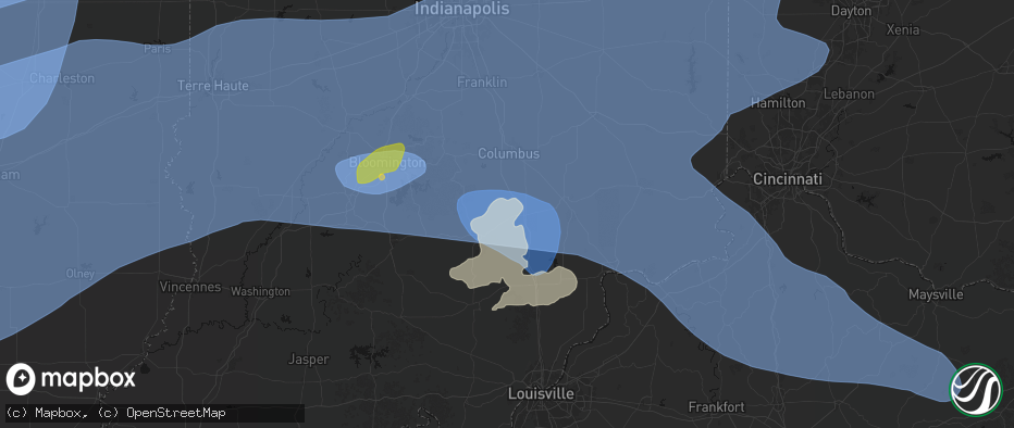
Hail
Wind
Tornado
0
Estimated number of impacted properties by a 1.00" hail or larger0
Estimated number of impacted properties by a 1.75" hail or larger0
Estimated number of impacted properties by a 2.50" hail or largerStorm reports in Seymour, IN
Seymour, IN
| Date | Description |
|---|---|
| 04/27/20264:04 PM CDT | A local report indicates 60 MPH wind near 2 NE Seymour |
| 04/27/20264:00 PM CDT | Damage to multiple power poles and house roofs. Time based on radar. |
| 04/27/20263:52 PM CDT | 30 power poles down. Time estimated from radar. |
| 04/27/20263:44 PM CDT | An ef-1 tornado with path length of 2.16 miles and path width of 100 yards began at this location. The peak winds were 105 mph with damage including snapped trees and t |
| 04/26/202611:05 PM CDT | Measured at kser awos. |
All States Impacted by Hail Map on April 27, 2026
All Cities Impacted by Hail Map on April 27, 2026
- Hoyleton, IL
- Centralia, IL
- Carlyle, IL
- Jonesboro, IL
- Hoffman, IL
- Macon, MO
- Excello, MO
- McLeansboro, IL
- Macedonia, IL
- Cobden, IL
- Anna, IL
- Dongola, IL
- Edwardsville, IL
- Worden, IL
- Moro, IL
- Brunswick, MO
- Makanda, IL
- Dalton, MO
- Charleston, MO
- East Prairie, MO
- Palmyra, IL
- Carlinville, IL
- Hettick, IL
- Greenfield, IL
- Sandoval, IL
- Buncombe, IL
- Bunker Hill, IL
- Staunton, IL
- Goreville, IL
- Anabel, MO
- Keytesville, MO
- Salisbury, MO
- New Douglas, IL
- Ozark, IL
- Vienna, IL
- Clarence, MO
- Novelty, MO
- Dorsey, IL
- Livingston, IL
- Odin, IL
- Cairo, MO
- Huntsville, MO
- Modesto, IL
- Clifton Hill, MO
- Girard, IL
- Creal Springs, IL
- Simpson, IL
- New Burnside, IL
- Moberly, MO
- Marion, IL
- Mount Olive, IL
- Walshville, IL
- Litchfield, IL
- Knox City, MO
- Shelbyville, MO
- Bethel, MO
- Edina, MO
- Leonard, MO
- Newark, MO
- Jacksonville, MO
- Slater, MO
- Malta Bend, MO
- Carrollton, MO
- Gilliam, MO
- Triplett, MO
- Bosworth, MO
- Marshall, MO
- De Witt, MO
- Miami, MO
- Glasgow, MO
- Mendon, MO
- Clark, MO
- Lentner, MO
- Shelbina, MO
- Callao, MO
- Armstrong, MO
- Bevier, MO
- Higbee, MO
- Harrisburg, MO
- Madison, MO
- Fayette, MO
- Marceline, MO
- New Cambria, MO
- Sturgeon, MO
- Paris, MO
- Holliday, MO
- Chesterfield, IL
- Medora, IL
- Jerseyville, IL
- Rockbridge, IL
- La Belle, MO
- Roodhouse, IL
- Virden, IL
- Burfordville, MO
- Jackson, MO
- Whitewater, MO
- Hunnewell, MO
- Centralia, MO
- Mexico, MO
- Emden, MO
- Thompson, MO
- Stoutsville, MO
- Santa Fe, MO
- Columbia, MO
- Hallsville, MO
- Broughton, IL
- Enfield, IL
- Loami, IL
- Waverly, IL
- Monroe City, MO
- Oak Ridge, MO
- Altenburg, MO
- Center, MO
- Laddonia, MO
- Philadelphia, MO
- Palmyra, MO
- Perry, MO
- Rush Hill, MO
- Farber, MO
- Grand Tower, IL
- Auburn, IL
- Hannibal, MO
- Vandalia, MO
- New London, MO
- Frohna, MO
- New Berlin, IL
- Wolf Lake, IL
- Murrayville, IL
- Curryville, MO
- Frankford, MO
- Gorham, IL
- Murphysboro, IL
- Tipton, MO
- Nokomis, IL
- Morrisonville, IL
- Carbondale, IL
- Pomona, IL
- Pinckneyville, IL
- Coulterville, IL
- Auxvasse, MO
- Chatham, IL
- McClure, IL
- Thebes, IL
- Tamms, IL
- Kinderhook, IL
- Hull, IL
- New Canton, IL
- Ashburn, MO
- Barry, IL
- Louisiana, MO
- Rockport, IL
- Bowling Green, MO
- Glenarm, IL
- Mulkeytown, IL
- Royalton, IL
- Elkville, IL
- De Soto, IL
- Springfield, IL
- Owaneco, IL
- West Frankfort, IL
- Taylorville, IL
- Benton, IL
- Christopher, IL
- Clarksville, MO
- Pleasant Hill, IL
- Griggsville, IL
- Pittsfield, IL
- Nebo, IL
- New Salem, IL
- Assumption, IL
- Rochester, IL
- Scheller, IL
- Sesser, IL
- Baylis, IL
- Waltonville, IL
- Orient, IL
- Mechanicsburg, IL
- Dawson, IL
- Ashley, IL
- Milton, IL
- Pearl, IL
- Hillview, IL
- Pawnee, IL
- Riverton, IL
- Woodlawn, IL
- Thompsonville, IL
- Logan, IL
- Mount Vernon, IL
- Winchester, IL
- Bluffs, IL
- Pleasant Plains, IL
- Athens, IL
- Sherman, IL
- Williamsville, IL
- Pittsburg, IL
- White Hall, IL
- Ashland, IL
- Alexander, IL
- Niantic, IL
- Illiopolis, IL
- Buffalo, IL
- Kampsville, IL
- Johnston City, IL
- Stonefort, IL
- Carrier Mills, IL
- Grantsburg, IL
- Warrensburg, IL
- Petersburg, IL
- Tallula, IL
- Golconda, IL
- Decatur, IL
- Mount Pulaski, IL
- Latham, IL
- Maroa, IL
- Dahlgren, IL
- Ewing, IL
- Galatia, IL
- Harrisburg, IL
- Franklin, IL
- Patterson, IL
- Woodson, IL
- Jacksonville, IL
- Carterville, IL
- Eddyville, IL
- Wrights, IL
- Herod, IL
- Greenview, IL
- Eldorado, IL
- Ingraham, IL
- Clay City, IL
- Dale, IL
- Equality, IL
- Norris City, IL
- Noble, IL
- Omaha, IL
- Cantrall, IL
- Wayne City, IL
- Argenta, IL
- Springerton, IL
- Fidelity, IL
- Junction, IL
- Ridgway, IL
- Bulpitt, IL
- Divernon, IL
- Edinburg, IL
- Waggoner, IL
- Tovey, IL
- Mount Auburn, IL
- Kincaid, IL
- Harvel, IL
- Farmersville, IL
- Thayer, IL
- Fairfield, IL
- Barnhill, IL
- Weldon, IL
- New Haven, IL
- Golden Gate, IL
- Hillsboro, IL
- Raleigh, IL
- Butler, IL
- Irving, IL
- Centertown, MO
- Witt, IL
- Carmi, IL
- Mount Vernon, IN
- Taylor Springs, IL
- Palmer, IL
- Olney, IL
- Fillmore, IL
- Pana, IL
- De Land, IL
- Bingham, IL
- New Harmony, IN
- Shawneetown, IL
- Lakewood, IL
- Tuscola, IL
- Stewardson, IL
- Boody, IL
- Moweaqua, IL
- Macon, IL
- Sadorus, IL
- La Place, IL
- Tolono, IL
- Dalton City, IL
- Mt Zion, IL
- Sullivan, IL
- Arcola, IL
- Strasburg, IL
- Blue Mound, IL
- Bement, IL
- Lovington, IL
- Pesotum, IL
- Tower Hill, IL
- Shelbyville, IL
- Findlay, IL
- Mode, IL
- Gays, IL
- Atwood, IL
- Hammond, IL
- Bethany, IL
- Rosamond, IL
- Arthur, IL
- Stonington, IL
- Windsor, IL
- Ivesdale, IL
- Cerro Gordo, IL
- Beecher City, IL
- Wadesville, IN
- Poseyville, IN
- Ramsey, IL
- Claremont, IL
- Donnellson, IL
- Mulberry Grove, IL
- Greenville, IL
- Sumner, IL
- Evansville, IN
- Cynthiana, IN
- Fredonia, KY
- Marion, KY
- Brownstown, IL
- Tebbetts, MO
- Mokane, MO
- Steedman, MO
- Fulton, MO
- Uniontown, KY
- Henderson, KY
- Corydon, KY
- Newburgh, IN
- Providence, KY
- Princeton, KY
- Saint Peters, MO
- Saint Charles, MO
- Saint Elmo, IL
- Chandler, IN
- Smithboro, IL
- Clay, KY
- Cowden, IL
- Sebree, KY
- Nebo, KY
- Slaughters, KY
- Dixon, KY
- Boonville, IN
- Sigel, IL
- Neoga, IL
- Hindsboro, IL
- Lerna, IL
- Philo, IL
- Camargo, IL
- Toledo, IL
- Sidney, IL
- Villa Grove, IL
- Trilla, IL
- Longview, IL
- Charleston, IL
- Mattoon, IL
- Humboldt, IL
- Manitou, KY
- Vandalia, IL
- Decker, IN
- Hazleton, IN
- Effingham, IL
- Earth City, MO
- Hazelwood, MO
- Bridgeton, MO
- Patoka, IN
- Montrose, IL
- Altamont, IL
- Oakland City, IN
- Francisco, IN
- Owensboro, KY
- Calhoun, KY
- Saint Ann, MO
- Saint Louis, MO
- Maryland Heights, MO
- Chesterfield, MO
- Florissant, MO
- Tennyson, IN
- Princeton, IN
- Monroe City, IN
- Westfield, IL
- Kansas, IL
- Casey, IL
- Ashmore, IL
- Vincennes, IN
- Martinsville, IL
- Marshall, IL
- Gentryville, IN
- Washington, IN
- Wheatland, IN
- Lincoln City, IN
- Chrisney, IN
- Santa Claus, IN
- Lamar, IN
- Dale, IN
- Newton, IL
- Evanston, IN
- Holland, IN
- West Union, IL
- West Liberty, IL
- Willow Hill, IL
- Augusta, MO
- Defiance, MO
- Labadie, MO
- Huntingburg, IN
- Terre Haute, IN
- Kincaid, KS
- Wildwood, MO
- Rockport, IN
- Ballwin, MO
- Salem, IL
- Loogootee, IN
- Saint Anthony, IN
- Ferdinand, IN
- Birdseye, IN
- Centerville, KS
- Blue Mound, KS
- Fairbanks, IN
- Farmersburg, IN
- West York, IL
- Farina, IL
- Kinmundy, IL
- Xenia, IL
- Parker, KS
- Mound City, KS
- Celestine, IN
- Schnellville, IN
- Taswell, IN
- Eckerty, IN
- Pleasanton, KS
- Sullivan, IN
- Jasonville, IN
- Louisville, IL
- Hermann, MO
- New Florence, MO
- Shoals, IN
- Mitchell, IN
- Bedford, IN
- Williams, IN
- Worthington, IN
- Clay City, IN
- Coal City, IN
- Freedom, IN
- La Cygne, KS
- Amoret, MO
- Adrian, MO
- Amsterdam, MO
- Butler, MO
- La Harpe, KS
- Moran, KS
- Bronson, KS
- South Roxana, IL
- Roxana, IL
- Hartford, IL
- Wood River, IL
- Dundas, IL
- Sailor Springs, IL
- Granite City, IL
- High Hill, MO
- Jonesburg, MO
- Rhineland, MO
- Truxton, MO
- Bethalto, IL
- Humboldt, KS
- Linton, IN
- Iola, KS
- Glen Carbon, IL
- Paoli, IN
- English, IN
- Marengo, IN
- Madison, IL
- Warrenton, MO
- Alhambra, IL
- Grafton, IL
- Bicknell, IN
- Rinard, IL
- Maryville, IL
- Collinsville, IL
- Edwardsport, IN
- Flora, IL
- Portage Des Sioux, MO
- Brussels, IL
- Golden Eagle, IL
- O'Fallon, MO
- Troy, IL
- Marine, IL
- Garden City, MO
- Drexel, MO
- Bloomington, IN
- Solsberry, IN
- Springville, IN
- Avoca, IN
- Oolitic, IN
- Troy, MO
- Wright City, MO
- Urich, MO
- Creighton, MO
- Carlisle, IN
- Blairstown, MO
- Chilhowee, MO
- Mapleton, KS
- Wesley, IA
- Montrose, MO
- Sorento, IL
- Hawk Point, MO
- Foristell, MO
- Clinton, MO
- Moscow Mills, MO
- Highland, IL
- Spencer, IN
- Nashville, IN
- Mount Erie, IL
- Lake Saint Louis, MO
- Wentzville, MO
- Lyons, IN
- Elnora, IN
- Newberry, IN
- Prescott, KS
- Fulton, KS
- Odon, IN
- Wooldridge, MO
- Prairie Home, MO
- Centerview, MO
- Jamestown, MO
- Switz City, IN
- Chanute, KS
- Elsmore, KS
- Odessa, MO
- Holden, MO
- Foster, MO
- Windsor, MO
- Leeton, MO
- Calhoun, MO
- Rocheport, MO
- Heltonville, IN
- Bloomfield, IN
- Norman, IN
- Crane, IN
- Concordia, MO
- Old Monroe, MO
- Rich Hill, MO
- Uniontown, KS
- Hume, MO
- Ellery, IL
- Albion, IL
- Calhoun, IL
- Parkersburg, IL
- Warrensburg, MO
- Green Ridge, MO
- Sweet Springs, MO
- West Salem, IL
- Boonville, MO
- Pilot Grove, MO
- Bridgeport, IL
- Montgomery, IN
- Lawrenceville, IL
- Flat Rock, IL
- Owensburg, IN
- Sedalia, MO
- Plainville, IN
- Bunceton, MO
- Fredonia, KS
- Smithton, MO
- Otterville, MO
- Syracuse, MO
- Florence, MO
- Brownstown, IN
- Freetown, IN
- Dow, IL
- Seymour, IN
- La Monte, MO
- Salem, IN
- Godfrey, IL
- Brighton, IL
- Saint Francisville, IL
- Houstonia, MO
- Nelson, MO
- Knob Noster, MO
- Diamond, MO
- Neosho, MO
- Joplin, MO
- Alton, IL
- West Alton, MO
- Elsah, IL
- Campbellsburg, IN
- Vallonia, IN
- Thayer, KS
- Fortuna, MO
- New Franklin, MO
- Scotland, IN
- West Baden Springs, IN
- Orleans, IN
- North Vernon, IN
- Austin, IN
- Scipio, IN
- Paris Crossing, IN
- Columbus, IN
- Crothersville, IN
- Commiskey, IN
- Deputy, IN
- Sarcoxie, MO
- Pierce City, MO
- Wentworth, MO
- Stotts City, MO
- Payson, IL
- Quincy, IL
- Mora, MO
- Cole Camp, MO
- Stover, MO
- Cottage Hills, IL
- Alta Vista, IA
- Granby, MO
- Benton City, MO
- Clarksburg, MO
- Wellsville, MO
- Osceola, MO
- Scottsburg, IN
- Franklin, MO
- Versailles, MO
- Martinsburg, MO
- California, MO
- Bone Gap, IL
- Galesburg, KS
- Saint Paul, KS
- Erie, KS
- Mount Vernon, MO
- Otwell, IN
- Mount Carmel, IL
- Allendale, IL
- Elma, IA
- Petersburg, IN
- Oblong, IL
- Ragsdale, IN
- Quincy, MO
- Latham, MO
- Camp Point, IL
- Aurora, MO
- Marionville, MO
- Billings, MO
- Ash Grove, MO
- Golden, IL
- Chambersburg, IL
- Perry, IL
- Barnett, MO
- Russellville, MO
- Noel, MO
- Kingdom City, MO
- New Hampton, IA
- Cresco, IA
- Shelburn, IN
- Monett, MO
- Clayton, IL
- Stark City, MO
- Browns, IL
- Republic, MO
- Jefferson City, MO
- Hartsburg, MO
- Everton, MO
- Cannelburg, IN
- Pineville, MO
- Ashland, MO
- Montgomery City, MO
- Williamsburg, MO
- Verona, MO
- Eldred, IL
- Gravette, AR
- Sulphur Springs, AR
- Jasper, IN
- Meredosia, IL
- Freistatt, MO
- Lohman, MO
- Gravois Mills, MO
- Eldon, MO
- Rocky Mount, MO
- Middletown, MO
- Brookline, MO
- Springfield, MO
- Rogersville, MO
- Buffalo, MO
- Elkland, MO
- Long Lane, MO
- Phillipsburg, MO
- Bella Vista, AR
- Walnut Grove, MO
- Willard, MO
- Teutopolis, IL
- Powell, MO
- Washburn, MO
- Purdy, MO
- San Jose, IL
- Atkins, IA
- Newhall, IA
- Ridgeway, IA
- Decorah, IA
- Huntsville, IL
- La Prairie, IL
- Dubois, IN
- Annada, MO
- Mason City, IL
- Beardstown, IL
- Arenzville, IL
- Tuscumbia, MO
- Eugene, MO
- Henley, MO
- Pea Ridge, AR
- Seligman, MO
- Virginia, IL
- Exeter, MO
- Cassville, MO
- Crane, MO
- Strafford, MO
- Fordland, MO
- Winfield, MO
- Foley, MO
- Olean, MO
- Nixa, MO
- Ozark, MO
- French Lick, IN
- Lebanon, MO
- Palo, IA
- Cedar Rapids, IA
- Silex, MO
- Pendleton, KY
- Bedford, KY
- Hiawatha, IA
- Shellsburg, IA
- Burnt Prairie, IL
- Grayville, IL
- Crossville, IL
- Mill Shoals, IL
- Saint Thomas, MO
- Batchtown, IL
- Dieterich, IL
- Chapin, IL
- New Bloomfield, MO
- Fairview, MO
- Stoutland, MO
- Montreal, MO
- Richland, MO
- Saint Elizabeth, MO
- Westphalia, MO
- Freeburg, MO
- Koeltztown, MO
- Meta, MO
- Holts Summit, MO
- Robins, IA
- Marion, IA
- Clever, MO
- Mackinaw, IL
- Tremont, IL
- Hopedale, IL
- Carrollton, IL
- Hardin, IL
- Fieldon, IL
- Eolia, MO
- Elsberry, MO
- Morton, IL
- Loose Creek, MO
- Hardinsburg, IN
- Milltown, IN
- Winslow, IN
- Bellmont, IL
- Seymour, MO
- Crocker, MO
- Bonnots Mill, MO
- Linn, MO
- Chamois, MO
- Bland, MO
- Argyle, MO
- Belle, MO
- Kane, IL
- Elkhart, IL
- Bellflower, MO
- Saint James, MO
- Cuba, MO
- Palmyra, IN
- Springville, IA
- Pekin, IN
- Depauw, IN
- Fredericksburg, IN
- Hamburg, IL
- Conway, MO
- Hartville, MO
- Mansfield, MO
- Marshfield, MO
- Dixon, MO
- Mount Sterling, MO
- Morrison, MO
- Owensville, MO
- Piasa, IL
- Shipman, IL
- Vichy, MO
- Truesdale, MO
- Bourbon, MO
- Leasburg, MO
- Laquey, MO
- Vienna, MO
- Velpen, IN
- Stendal, IN
- Rolla, MO
- Middletown, IL
- Oaktown, IN
- Marthasville, MO
- Mountain Grove, MO
- Norwood, MO
- Sullivan, MO
- Rosebud, MO
- Gerald, MO
- Leslie, MO
- New Haven, MO
- Chandlerville, IL
- Oakford, IL
- Lincoln, IL
- Sparta, MO
- Ava, MO
- Milmine, IL
- New Holland, IL
- Owensville, IN
- Chestnut, IL
- Beason, IL
- Bruner, MO
- Berger, MO
- Ponce De Leon, MO
- Highlandville, MO
- Galena, MO
- Clinton, IL
- Kenney, IL
- Saint Clair, MO
- Villa Ridge, MO
- Union, MO
- Robertsville, MO
- Harristown, IL
- Downs, IL
- Wapella, IL
- Waynesville, IL
- Le Roy, IL
- Atlanta, IL
- Heyworth, IL
- McLean, IL
- Catawissa, MO
- Pacific, MO
- Gray Summit, MO
- Eureka, MO
- Cabool, MO
- Graff, MO
- Monticello, IL
- Washington, MO
- Garfield, AR
- Beaufort, MO
- Farmersville, TX
- Shell Knob, MO
- Gillespie, IL
- Raymond, IL
- Edgar Springs, MO
- Reeds Spring, MO
- Rogers, AR
- Salem, MO
- Cape Fair, MO
- Lonedell, MO
- Dittmer, MO
- Grubville, MO
- Richwoods, MO
- Luebbering, MO
- Elk Creek, MO
- Houston, MO
- Solo, MO
- Drury, MO
- Hillsboro, MO
- Cook Sta, MO
- Rosedale, IN
- Clinton, IN
- Branson, MO
- Nilwood, IL
- Grand Prairie, TX
- Dallas, TX
- Irving, TX
- East Alton, IL
- Yukon, MO
- Summersville, MO
- Raymondville, MO
- Eunice, MO
- Oldfield, MO
- Montezuma, IN
- Rockville, IN
- White Heath, IL
- Vanzant, MO
- Dora, MO
- Crescent City, IL
- Arrowsmith, IL
- Farmer City, IL
- Onarga, IL
- Loda, IL
- Mahomet, IL
- Gibson City, IL
- Oreana, IL
- Saybrook, IL
- Mansfield, IL
- Forsyth, IL
- Cisco, IL
- Sibley, IL
- Buckley, IL
- Bellflower, IL
- Fisher, IL
- Foosland, IL
- Paxton, IL
- Roberts, IL
- Melvin, IL
- Elliott, IL
- Dewitt, IL
- Lane, IL
- Saunemin, IL
- Cullom, IL
- Ellsworth, IL
- Cropsey, IL
- Colfax, IL
- Forrest, IL
- Fairbury, IL
- Chenoa, IL
- Cooksville, IL
- Bloomington, IL
- Towanda, IL
- Lexington, IL
- Pontiac, IL
- Gridley, IL
- Normal, IL
- Anchor, IL
- Strawn, IL
- Chatsworth, IL
- Fenton, MO
- High Ridge, MO
- Saint Albans, MO
- Valley Park, MO
- Seymour, IL
- Hartshorn, MO
- Willow Springs, MO
- Celeste, TX
- Macomb, MO
- Rockaway Beach, MO
- Powersite, MO
- Forsyth, MO
- Kirbyville, MO
- Kissee Mills, MO
- Griffin, IN
- Taneyville, MO
- Rowlett, TX
- Richardson, TX
- Bradleyville, MO
- Rueter, MO
- Thornfield, MO
- Theodosia, MO
- Steelville, MO
- Barnhart, MO
- Imperial, MO
- Cedar Hill, MO
- Arnold, MO
- House Springs, MO
- Pevely, MO
- Garland, TX
- Bruceville, IN
- Grantsburg, IN
- Greenville, TX
- Dundee, MS
- Crenshaw, MS
- Sarah, MS
- Cherryville, MO
- Davisville, MO
- Hamel, IL
- Pomona, MO
- Mountain View, MO
- Plano, TX
- Noble, MO
- Wasola, MO
- Gainesville, MO
- Mesquite, TX
- Eminence, MO
- Potosi, MO
- Sachse, TX
- Roachdale, IN
- Russellville, IN
- Isabella, MO
- Wilsonville, IL
- Pocahontas, IL
- Urbana, IL
- Champaign, IL
- Valmeyer, IL
- Oconee, IL
- Wolfe City, TX
- Waterloo, IL
- Columbia, IL
- Millstadt, IL
- East Saint Louis, IL
- East Carondelet, IL
- Dupo, IL
- Herculaneum, MO
- Wylie, TX
- Allen, TX
- Princeton, TX
- Benld, IL
- Sawyerville, IL
- Ladoga, IN
- Viburnum, MO
- Thomasboro, IL
- Piper City, IL
- Rantoul, IL
- Dewey, IL
- Watseka, IL
- Cissna Park, IL
- Gilman, IL
- Gifford, IL
- Rankin, IL
- Thawville, IL
- Ludlow, IL
- Milford, IL
- Bondville, IL
- Potomac, IL
- Newman, IL
- Saint Joseph, IL
- Penfield, IL
- Broadlands, IL
- Savoy, IL
- Ogden, IL
- Royal, IL
- Homer, IL
- Armstrong, IL
- Herrick, IL
- Lovejoy, IL
- Venice, IL
- Belleville, IL
- New Athens, IL
- Smithton, IL
- O'Fallon, IL
- Freeburg, IL
- Fairview Heights, IL
- New Ross, IN
- Commerce, TX
- Coffeen, IL
- De Soto, MO
- Festus, MO
- Panama, IL
- Calhan, CO
- Belgrade, MO
- Pontiac, MO
- Collison, IL
- Hoopeston, IL
- Stockland, IL
- Brook, IN
- Donovan, IL
- Fithian, IL
- Sheldon, IL
- Wellington, IL
- Kentland, IN
- Rossville, IL
- Earl Park, IN
- West Plains, MO
- Hardenville, MO
- Udall, MO
- Caulfield, MO
- Tecumseh, MO
- Rockwall, TX
- Red Bud, IL
- Hecker, IL
- Trenton, IL
- Klondike, TX
- Royse City, TX
- Saint Jacob, IL
- New Baden, IL
- Scott Air Force Base, IL
- Albers, IL
- Aviston, IL
- Mascoutah, IL
- Summerfield, IL
- Breese, IL
- Germantown, IL
- Lebanon, IL
- Bartelso, IL
- Shumway, IL
- Keyesport, IL
- Lenzburg, IL
- Indianola, IL
- Oakwood, IL
- Fairmount, IL
- Allerton, IL
- Zanoni, MO
- Crystal City, MO
- Irondale, MO
- Caledonia, MO
- Cumby, TX
- Peace Valley, MO
- Birch Tree, MO
- Moody, MO
- Pottersville, MO
- Bakersfield, MO
- Ohlman, IL
- Saint Libory, IL
- Marissa, IL
- Oakdale, IL
- Nashville, IL
- Addieville, IL
- Blue Ridge, TX
- Leonard, TX
- Caseyville, IL
- Alton, MO
- Gepp, AR
- Otterbein, IN
- Boswell, IN
- Pine Village, IN
- Templeton, IN
- Catlin, IL
- Covington, IN
- Goodland, IN
- Muncie, IL
- Tilton, IL
- Henning, IL
- West Lebanon, IN
- West Lafayette, IN
- Bismarck, IL
- Ambia, IN
- State Line, IN
- Danville, IL
- Remington, IN
- Fowler, IN
- Williamsport, IN
- Westville, IL
- Brookston, IN
- Oxford, IN
- Attica, IN
- Alvin, IL
- Viola, AR
- Wolcott, IN
- Westpoint, IN
- Metcalf, IL
- Sidell, IL
- Ridge Farm, IL
- Georgetown, IL
- Perrysville, IN
- Hume, IL
- Veedersburg, IN
- Lafayette, IN
- Okawville, IL
- Beckemeyer, IL
- Patoka, IL
- Vernon, IL
- Shobonier, IL
- Koshkonong, MO
- Sturkie, AR
- Fremont, MO
- Winona, MO
- Quinlan, TX
- Terrell, TX
- Newtown, IN
- Wingate, IN
- Park Hills, MO
- Doe Run, MO
- Farmington, MO
- New Richmond, IN
- Romney, IN
- Chrisman, IL
- Bloomingdale, IN
- Kingman, IN
- Hillsboro, IN
- Mellott, IN
- Cayuga, IN
- Dana, IN
- Sulphur Springs, TX
- Bismarck, MO
- Mineral Point, MO
- Leadwood, MO
- Bonne Terre, MO
- Greenup, IL
- Jewett, IL
- Merrimac, WI
- Saint Peter, IL
- Ellington, MO
- Alma, IL
- Tilden, IL
- Sparta, IL
- Baldwin, IL
- Edgewood, IL
- Mason, IL
- Watson, IL
- Brocton, IL
- Richview, IL
- Oakland, IL
- Fults, IL
- Gamaliel, AR
- Dike, TX
- Ladonia, TX
- Crawfordsville, IN
- Waynetown, IN
- Rossville, IN
- Dayton, IN
- Delphi, IN
- Mulberry, IN
- Paris, IL
- Clarks Hill, IN
- New Market, IN
- Darlington, IN
- Alamo, IN
- Linden, IN
- Wheeler, IL
- Walnut Hill, IL
- Iuka, IL
- Hidalgo, IL
- Dix, IL
- Texico, IL
- Kell, IL
- Yale, IL
- Sainte Marie, IL
- Johnsonville, IL
- Irvington, IL
- Sainte Genevieve, MO
- Doniphan, MO
- Van Buren, MO
- Salem, AR
- Du Bois, IL
- Tamaroa, IL
- Bonham, TX
- Prairie Du Rocher, IL
- Lone Oak, TX
- Point, TX
- Sulphur Bluff, TX
- Saltillo, TX
- Frankfort, IN
- Colfax, IN
- Mount Vernon, TX
- Thorntown, IN
- Camp, AR
- Mammoth Spring, AR
- Thayer, MO
- Grandin, MO
- Saint Mary, MO
- Honey Grove, TX
- Emory, TX
- Rio, WI
- Poynette, WI
- Pardeeville, WI
- Greenville, IN
- Wills Point, TX
- Sunnyvale, TX
- Nevada, TX
- Portage, WI
- Baraboo, WI
- Mountain Home, AR
- Ironton, MO
- West Terre Haute, IN
- Dennison, IL
- Vermilion, IL
- New Goshen, IN
- Annapolis, IL
- Waterford, MS
- Potts Camp, MS
- Clarkridge, AR
- Hickory Flat, MS
- Kokomo, IN
- Cutler, IN
- Russiaville, IN
- Forest, IN
- Michigantown, IN
- Sharpsville, IN
- Jamestown, IN
- Kempton, IN
- Kirklin, IN
- Lebanon, IN
- Advance, IN
- Mecca, IN
- Universal, IN
- Perryville, MO
- Du Quoin, IL
- Bonnie, IL
- Keenes, IL
- Bluford, IL
- Dane, WI
- Cambria, WI
- Ravenden, AR
- Bloomsdale, MO
- Cutler, IL
- Brazil, IN
- Fredericktown, MO
- Patterson, MO
- Sims, IL
- Elizabeth, AR
- Myrtle, MS
- Amboy, IN
- Bunker Hill, IN
- Converse, IN
- Greentown, IN
- Blue Mountain, MS
- Waunakee, WI
- Deforest, WI
- Calico Rock, AR
- Geff, IL
- Cisne, IL
- Piedmont, MO
- Pocahontas, AR
- Belle Rive, IL
- Opdyke, IL
- Campbell, TX
- Wabash, IN
- Greenville, MO
- Silva, MO
- Marshall, AR
- Rockwood, IL
- Jacob, IL
- Ava, IL
- Greencastle, IN
- Cory, IN
- Putnamville, IN
- Centerpoint, IN
- Carbon, IN
- Staunton, IN
- Harmony, IN
- Pimento, IN
- Bridgeton, IN
- Robinson, IL
- Knightsville, IN
- Danville, IN
- Amo, IN
- Stoy, IL
- Cloverdale, IN
- Poland, IN
- Bainbridge, IN
- Coatesville, IN
- Palestine, IL
- Fillmore, IN
- Riley, IN
- Reelsville, IN
- Hutsonville, IL
- Merom, IN
- Lewis, IN
- Dolph, AR
- Bexar, AR
- Wideman, AR
- Oxford, AR
- Fairdealing, MO
- Poplar Bluff, MO
- Harviell, MO
- Windfall, IN
- Tipton, IN
- Frankton, IN
- Summitville, IN
- Whitestown, IN
- La Fontaine, IN
- Goldsmith, IN
- Atlanta, IN
- Marion, IN
- Jonesboro, IN
- Fairmount, IN
- Cicero, IN
- Alexandria, IN
- Sweetser, IN
- Arcadia, IN
- Sheridan, IN
- Elwood, IN
- Swayzee, IN
- Westfield, IN
- Noblesville, IN
- Zionsville, IN
- Gaston, IN
- Fowlerton, IN
- Gas City, IN
- Springport, IN
- Muncie, IN
- Warren, IN
- Carmel, IN
- Pendleton, IN
- Lapel, IN
- Lagro, IN
- Matthews, IN
- Shirley, IN
- Van Buren, IN
- Huntington, IN
- Yorktown, IN
- Andrews, IN
- Markleville, IN
- Indianapolis, IN
- Fortville, IN
- Fishers, IN
- Mccordsville, IN
- Middletown, IN
- Upland, IN
- Daleville, IN
- Anderson, IN
- Whittington, IL
- Ina, IL
- Camby, IN
- Gosport, IN
- Stilesville, IN
- Monrovia, IN
- Quincy, IN
- Avon, IN
- Bowling Green, IN
- West Newton, IN
- Hymera, IN
- Patricksburg, IN
- Plainfield, IN
- Clayton, IN
- Brooklyn, IN
- Martinsville, IN
- Ellettsville, IN
- Paragon, IN
- Freelandville, IN
- Mooresville, IN
- Coalmont, IN
- Sandborn, IN
- Dugger, IN
- Ash Flat, AR
- Glencoe, AR
- Horseshoe Bend, AR
- Wiseman, AR
- Neelyville, MO
- Secor, IL
- Congerville, IL
- Eureka, IL
- Goodfield, IL
- Carlock, IL
- Metamora, IL
- Warm Springs, AR
- Cherokee Village, AR
- Hardy, AR
- Armington, IL
- Minier, IL
- Old Appleton, MO
- Uniontown, MO
- Underwood, IN
- Lexington, IN
- Danvers, IL
- Farrar, MO
- Williford, AR
- Maynard, AR
- Ravenden Springs, AR
- Leslie, AR
- Pelsor, AR
- Mount Judea, AR
- Deer Creek, IL
- Washington, IL
- Alto Pass, IL
- Albany, IN
- New Castle, IN
- Eaton, IN
- Selma, IN
- Hartford City, IN
- Montpelier, IN
- Markle, IN
- Mooreland, IN
- Gipsy, MO
- Qulin, MO
- Broseley, MO
- Fisk, MO
- Vendor, AR
- Herrin, IL
- Timbo, AR
- Fox, AR
- Tilly, AR
- Witts Springs, AR
- Hector, AR
- Morgantown, KY
- Lewisburg, KY
- Energy, IL
- Freeman Spur, IL
- Hurst, IL
- Zeigler, IL
- Cambria, IL
- Buckner, IL
- Corning, AR
- Datto, AR
- Biggers, AR
- Mountain View, AR
- Parker City, IN
- Ridgeville, IN
- Farmland, IN
- Knobel, AR
- Peach Orchard, AR
- Cumberland Furnace, TN
- Cunningham, TN
- Paragould, AR
- Poughkeepsie, AR
- Delaplaine, AR
- Imboden, AR
- Bargersville, IN
- Unionville, IN
- Grammer, IN
- Beech Grove, IN
- Knightstown, IN
- Rushville, IN
- New Palestine, IN
- Arlington, IN
- Edinburgh, IN
- Boggstown, IN
- Carthage, IN
- Waldron, IN
- Lewisville, IN
- Elizabethtown, IN
- Greenfield, IN
- Franklin, IN
- Greensburg, IN
- Trafalgar, IN
- Fairland, IN
- Jonesville, IN
- Homer, IN
- Manilla, IN
- Taylorsville, IN
- Mays, IN
- Morgantown, IN
- Shelbyville, IN
- Charlottesville, IN
- Hope, IN
- Morristown, IN
- Stinesville, IN
- Maxwell, IN
- Wilkinson, IN
- Ingalls, IN
- Flat Rock, IN
- Hartsville, IN
- Spiceland, IN
- Fountaintown, IN
- Whiteland, IN
- Greenwood, IN
- Kennard, IN
- Clifford, IN
- Needham, IN
- Milroy, IN
- Saint Paul, IN
- Nineveh, IN
- Gwynneville, IN
- Westport, IN
- Fort Branch, IN
- Straughn, IN
- Venedocia, OH
- Dunkirk, IN
- Bryant, IN
- Greenville, OH
- Uniondale, IN
- Salamonia, IN
- Monroe, IN
- Saint Henry, OH
- Keystone, IN
- Coldwater, OH
- Yorkshire, OH
- Wren, OH
- Modoc, IN
- Celina, OH
- Craigville, IN
- Ansonia, OH
- Osgood, OH
- Mendon, OH
- Berne, IN
- Union City, IN
- Union City, OH
- Rossburg, OH
- Geneva, IN
- Ossian, IN
- Rockford, OH
- Pennville, IN
- Burkettsville, OH
- Willshire, OH
- Poneto, IN
- Fort Recovery, OH
- Liberty Center, IN
- Van Wert, OH
- Bluffton, IN
- Williamsburg, IN
- Petroleum, IN
- Losantville, IN
- Versailles, OH
- Decatur, IN
- Lynn, IN
- Redkey, IN
- Portland, IN
- Saratoga, IN
- Ohio City, OH
- Maria Stein, OH
- Winchester, IN
- Bradford, OH
- Montezuma, OH
- Gettysburg, OH
- New Weston, OH
- Pleasant Grove, AR
- Evening Shade, AR
- Scottsville, KY
- Spurgeon, IN
- Haubstadt, IN
- Elberfeld, IN
- Franklin, AR
- Lafe, AR
- Black Rock, AR
- Rector, AR
- Lynnville, IN
- Scott City, MO
- Miller City, IL
- Olive Branch, IL
- Morganfield, KY
- Marmaduke, AR
- Bernie, MO
- Goodlettsville, TN
- Elizabethtown, IL
- Sturgis, KY
- Cave In Rock, IL
- Smithville, AR
- Walnut Ridge, AR
- Waverly, KY
- Sage, AR
- Melbourne, AR
- Nunnelly, TN
- Eldorado, OH
- Brookville, IN
- Milan, IN
- Laurel, IN
- Metamora, IN
- Milton, IN
- Lawrenceburg, IN
- Webster, IN
- Lewisburg, OH
- Liberty, IN
- New Paris, OH
- Osgood, IN
- Butlerville, IN
- Oldenburg, IN
- Okeana, OH
- Cedar Grove, IN
- Economy, IN
- Falmouth, IN
- New Trenton, IN
- West Harrison, IN
- Batesville, IN
- West College Corner, IN
- Palestine, OH
- Camden, OH
- Fountain City, IN
- Greens Fork, IN
- Holton, IN
- New Madison, OH
- Richmond, IN
- Cambridge City, IN
- Boston, IN
- Hollansburg, OH
- Versailles, IN
- Bath, IN
- Centerville, IN
- Connersville, IN
- Eaton, OH
- Brownsville, IN
- Hagerstown, IN
- West Manchester, OH
- Glenwood, IN
- College Corner, OH
- Oxford, OH
- Arcanum, OH
- Sunman, IN
- Napoleon, IN
- Moores Hill, IN
- Guilford, IN
- Aurora, IN
- Batesville, AR
- Powhatan, AR
- Portia, AR
- Medora, IN
- Dupont, IN
- Vernon, IN
- Madison, IN
- Dillsboro, IN
- New Knoxville, OH
- Chickasaw, OH
- Botkins, OH
- Fort Loramie, OH
- Covington, OH
- Houston, OH
- Spencerville, OH
- Anna, OH
- Saint Marys, OH
- Russia, OH
- Wapakoneta, OH
- Buckland, OH
- Sidney, OH
- Minster, OH
- New Bremen, OH
- Piqua, OH
- Gallatin, TN
- Hendersonville, TN
- Reed, KY
- Charlotte, TN
- Southside, TN
- Shirley, AR
- Kennett, MO
- Senath, MO
- O'Kean, AR
- Beech Grove, AR
- Bono, AR
- Hoxie, AR
- Richland, IN
- Rosiclare, IL
- Marcella, AR
- Olmsted, IL
- Grand Chain, IL
- La Center, KY
- Villa Ridge, IL
- Alicia, AR
- Ashland City, TN
- Chapmansboro, TN
- Jonesboro, AR
- Westmoreland, TN
- Metropolis, IL
- Karnak, IL
- Kevil, KY
- Saint Meinrad, IN
- Tell City, IN
- Salem, KY
- Grandview, IN
- Ramsey, IN
- Hampton, KY
- Smithland, KY
- Borden, IN
- Clarksville, TN
- New Madrid, MO
- Locust Grove, AR
- Sulphur Rock, AR
- Desha, AR
- Steele, MO
- Hornersville, MO
- Blytheville, AR
- Ludlow Falls, OH
- Cross Plains, IN
- Pleasant Hill, OH
- Laura, OH
- Canaan, IN
- West Milton, OH
- Brookville, OH
- Pitsburg, OH
- Troy, OH
- Englewood, OH
- Verona, OH
- Greenway, AR
- Gobler, MO
- Bragg City, MO
- Lewisport, KY
- Charlotte, AR
- Newark, AR
- Madison, TN
- Nashville, TN
- Springfield, TN
- Cedar Hill, TN
- Pleasant View, TN
- Parsons, TN
- Robards, KY
- Pinson, TN
- Joelton, TN
- Cardwell, MO
- Arbyrd, MO
- Scotts Hill, TN
- Medon, TN
- Toone, TN
- Lexington, TN
- Reagan, TN
- Darden, TN
- Edgemont, AR
- Whites Creek, TN
- Vevay, IN
- Milton, KY
- Carrollton, KY
- Ghent, KY
- Bennington, IN
- Sanders, KY
- Campbellsburg, KY
- Owenton, KY
- Turners Station, KY
- Worthville, KY
- Pleasureville, KY
- Perry Park, KY
- Bethlehem, KY
- Warsaw, KY
- Lockport, KY
- Rising Sun, IN
- New Liberty, KY
- Florence, IN
- Frankfort, KY
- Sparta, KY
- Walton, KY
- Verona, KY
- Burlington, KY
- Dry Ridge, KY
- Glencoe, KY
- Union, KY
- Petersburg, KY
- Patriot, IN
- Decaturville, TN
- Brookport, IL
- Henderson, TN
- Sugar Tree, TN
- Burna, KY
- Utica, KY
- Prim, AR
- Higden, AR
- Drasco, AR
- Concord, AR
- Cord, AR
- Bethpage, TN
- Hawesville, KY
- Linden, TN
- Philpot, KY
- Whitesville, KY
- Reynolds Station, KY
- Floral, AR
- Finger, TN
- Brookland, AR
- Dickson, TN
- Tuckerman, AR
- Newport, AR
- McEwen, TN
- Castalian Springs, TN
- Mount Juliet, TN
- Tumbling Shoals, AR
- Morning View, KY
- Crittenden, KY
- Hanson, KY
- Madisonville, KY
- Seven Mile, OH
- Somerville, OH
- Middletown, OH
- Franklin, OH
- Farmersville, OH
- Miamisburg, OH
- Germantown, OH
- Trenton, OH
- Hamilton, OH
- West Alexandria, OH
- Burns, TN
- Cloverport, KY
- White Bluff, TN
- Hartford, KY
- Eddyville, KY
- Olaton, KY
- Livermore, KY
- Bon Aqua, TN
- Centertown, KY
- Hardinsburg, KY
- Falls Of Rough, KY
- Bremen, KY
- Central City, KY
- Sacramento, KY
- Magness, AR
- Williamstown, KY
- Jonesville, KY
- Bethel Springs, TN
- Monette, AR
- Hartsville, TN
- Enville, TN
- Corinth, KY
- Sadieville, KY
- Stamping Ground, KY
- Berry, KY
- Falmouth, KY
- De Mossville, KY
- Cynthiana, KY
- Mercer, TN
- Denmark, TN
- Dyersburg, TN
- Friendship, TN
- Horse Branch, KY
- Caneyville, KY
- Lobelville, TN
- Georgetown, KY
- Pleasant Plains, AR
- Bradford, AR
- Westport, KY
- Powderly, KY
- Greenville, KY
- Old Hickory, TN
- Fordsville, KY
- Butler, KY
- Kuttawa, KY
- Fairview, TN
- Wilburn, AR
- Heber Springs, AR
- Dixon Springs, TN
- Sardis, TN
- Judsonia, AR
- Lake City, AR
- Vanleer, TN
- Kingston Springs, TN
- Beaver Dam, KY
- McHenry, KY
- Alamo, TN
- Pegram, TN
- Brownsville, TN
- Dundee, KY
- Adamsville, TN
- Morris Chapel, TN
- Milledgeville, TN
- Black Oak, AR
- Leachville, AR
- Mount Olivet, KY
- Brooksville, KY
- Carlisle, KY
- Mayslick, KY
- Ewing, KY
- Millersburg, KY
- North Middletown, KY
- Paris, KY
- Moorefield, KY
- Flemingsburg, KY
- Millwood, KY
- Leitchfield, KY
- Clifton, TN
- Dawson Springs, KY
- Pleasant Shade, TN
- Carthage, TN
- Waynesboro, TN
- Hohenwald, TN
- Bath Springs, TN
- Savannah, TN
- Crofton, KY
- White Plains, KY
- Franklin, TN
- Etowah, AR
- Cromwell, KY
- Humboldt, TN
- Gadsden, TN
- Whitleyville, TN
- Gainesboro, TN
- Elkton, KY
- Trenton, TN
- Sharpsburg, KY
- Hillsboro, KY
- Owingsville, KY
- Harrisburg, AR
- Jackson, TN
- Lafayette, TN
- Clarkson, KY
- Brownsville, KY
- Caraway, AR
- Drakesboro, KY
- Browder, KY
- Red Boiling Springs, TN
- Brentwood, TN
- Dover, TN
- Tennessee Ridge, TN
- Trumann, AR
- Manila, AR
- Cumberland City, TN
- Medina, TN
- Summertown, TN
- White Mills, KY
- Sonora, KY
- Big Clifty, KY
- Woodlawn, TN
- Cedar Grove, TN
- Milan, TN
- Lavinia, TN
- Palmyra, TN
- Indian Mound, TN
- Beechmont, KY
- Belton, KY
- Beech Creek, KY
- Dunmor, KY
- Osceola, AR
- Keiser, AR
- Rochester, KY
- Oakfield, TN
- Stewart, TN
- Bee Spring, KY
- Mammoth Cave, KY
- Roundhill, KY
- Munfordville, KY
- Cub Run, KY
- Lepanto, AR
- Dyess, AR
- Marked Tree, AR
- Scottsboro, AL
- Erin, TN
- Hampshire, TN
- Waverly, TN
- Bradford, TN
- Huron, TN
- Beech Bluff, TN
- Oil Trough, AR
- Pembroke, KY
- Bonnieville, KY
- Tyronza, AR
- Joiner, AR
- Cave City, AR
- Hopkinsville, KY
- Lawrenceburg, TN
- Mount Pleasant, TN
- Lynnville, TN
- Ethridge, TN
- Culleoka, TN
- Pulaski, TN
- Belfast, TN
- Cornersville, TN
- Lewisburg, TN
- Trenton, KY
- Horse Cave, KY
- Fackler, AL
- Stevenson, AL
- Hollywood, AL
- Russellville, KY
- Guthrie, KY
- Campbellsville, KY
- Greensburg, KY
- Roby, TX
- Cave City, KY
- Magnolia, KY
- Summersville, KY
- Mount Sherman, KY
- Frenchmans Bayou, AR
- Bassett, AR
- Wilson, AR
- Flat Rock, AL
- Madison, AL
- Decatur, AL
- Only, TN
- Auburn, KY
- Drummonds, TN
- Wynne, AR
- Columbia, TN
- Bryant, AL
- Millington, TN
- Turrell, AR
- Memphis, TN
- Munford, TN
- Marion, AR
- Trenton, GA
- Chattanooga, TN
- Lookout Mountain, TN
- Lookout Mountain, GA
- Flintstone, GA
- Rossville, GA
- Wildwood, GA
- Rotan, TX
- Woodburn, KY
- Rockfield, KY
- Bowling Green, KY
- Brownsburg, IN
- Greenbrier, TN
- Somerville, AL
- Hartselle, AL
- Arlington, TN
- Cordova, TN
- Whiteville, TN
- Oakland, TN
- Eads, TN
- Rossville, TN
- Collierville, TN
- Buck Creek, IN
- Bringhurst, IN
- Southaven, MS
- Walls, MS
- Snyder, TX
- Mason, TN
- Brighton, TN
- Danville, AL
- Moulton, AL
- Trinity, AL
- Batesville, MS
- Courtland, MS
- Sardis, MS
- Aspermont, TX
- Germantown, TN
- Post, TX
- Justiceburg, TX
- Hughes, AR
- Taylor, MS
- Oxford, MS
- Olive Branch, MS
- Crosbyton, TX
- Spur, TX
- Water Valley, MS
- Jayton, TX
- Girard, TX
- Portland, TN
- Tahoka, TX
- Paducah, TX
- Paris, MS
- Banner, MS
- Randolph, MS
- Houlka, MS
- Pontotoc, MS
- Bruce, MS
- Senatobia, MS
- Coffeeville, MS
- Seymour, TX
- Huntsville, AL
- Benjamin, TX
- Thaxton, MS
- Upton, KY
- Pollard, AR


