Hail Map in Iowa on May 17, 2026
The weather event in Iowa on May 17, 2026 includes Hail, Wind, and Tornado maps. 13 states and 1,536 cities were impacted and suffered possible damage. The total estimated number of properties impacted is 12,142.
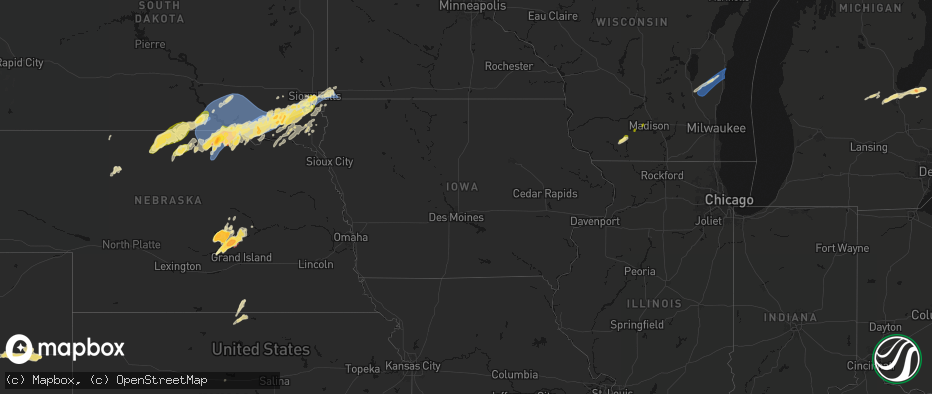
Hail
Wind
Tornado
12,142
Estimated number of impacted properties by a 1.00" hail or larger1,164
Estimated number of impacted properties by a 1.75" hail or larger0
Estimated number of impacted properties by a 2.50" hail or largerStorm reports in Iowa
Iowa
| Date | Description |
|---|---|
| 05/17/20266:50 PM CDT | Photo via social media. Time estimated by radar. |
| 05/17/20266:43 PM CDT | Photo via social media. Time estimated via radar. |
| 05/17/20265:14 PM CDT | Social media report with picture and coin for size comparison. Time estimated by radar. |
| 05/17/20263:54 AM CDT | A local report indicates 1.00 inch wind near 1 WSW Bettendorf |
| 05/17/20263:51 AM CDT | A local report indicates 1.25 inch wind near 2 N Bettendorf |
| 05/17/20263:51 AM CDT | Half dollar size hail reported by off duty nws employee. |
| 05/17/202612:44 AM CDT | Two power poles snapped north of town near hwy 13. Time estimated from radar. |
| 05/16/202610:34 PM CDT | A local report indicates 70 MPH wind near Nora Springs |
| 05/16/202610:27 PM CDT | Local fire reports tornado on ground. |
| 05/16/202610:25 PM CDT | A local report indicates 69 MPH wind near 4 WNW Mason City |
| 05/16/202610:24 PM CDT | Local fire reports tornado on ground. Time estimated via radar. |
| 05/16/202610:21 PM CDT | Fire reported tornado on ground. Time estimated via radar. |
| 05/16/202610:18 PM CDT | A local report indicates 63 MPH wind near 6 NNW Rockwell |
| 05/16/202610:11 PM CDT | A local report indicates 67 MPH wind near 6 NE Ledyard |
| 05/16/202610:10 PM CDT | Structure damage. Time estimated via radar. |
| 05/16/202610:10 PM CDT | A local report indicates 62 MPH wind near 5 NW Thompson |
| 05/16/20269:59 PM CDT | Reports of power line sparking/flashing. |
| 05/16/20269:42 PM CDT | Couple of trees down. Time estimated via radar. |
| 05/16/20269:41 PM CDT | Asos station kest estherville airport. |
| 05/16/20269:39 PM CDT | Downed tree limb on home. Time estimated via radar. |
| 05/16/20269:38 PM CDT | Confirmed tornado via emergency management. |
| 05/16/20269:34 PM CDT | Semi tipped over. |
| 05/16/20269:33 PM CDT | Delayed report - received photo on social media of large tree limb on home. |
| 05/16/20269:33 PM CDT | Tree uprooted near lone rock. Delayed report from broadcast media... Time estimated by radar. |
| 05/16/20269:28 PM CDT | Confirmed tornado estimated via webcam. |
| 05/16/20269:27 PM CDT | Multiple trees down upwards of 8 inches in diameter. Time estimated via radar. |
| 05/16/20269:23 PM CDT | 2-3 inch diameter limbs down. Time estimated via radar. |
| 05/16/20269:19 PM CDT | Personal weather station. |
| 05/16/20269:16 PM CDT | Personal weather station. |
| 05/16/20269:14 PM CDT | Reports of power pole and tree damage in town. Time estimated by radar. |
| 05/16/20269:12 PM CDT | Via personal weather station. |
| 05/16/20269:12 PM CDT | Daily cocorahs observer notes from ia-pa-5 stated there was damage to a machine shed 1 mile ese of their location... Which is the location of this report. Time estimate |
| 05/16/20269:10 PM CDT | Delayed report - report of trees and power lines down in rockwell city. Time estimated from radar. |
| 05/16/20269:08 PM CDT | Viewed on social media. |
| 05/16/20269:05 PM CDT | Between pocahontas and havelock. |
| 05/16/20269:01 PM CDT | Local fire department reports tornado. |
| 05/16/20268:55 PM CDT | A local report indicates 70 MPH wind near Sac City |
| 05/16/20268:51 PM CDT | Via personal weather station. |
| 05/16/20268:49 PM CDT | Damage to the greenville grain elevator. Branches and power lines also downed. Time estimated from radar. |
| 05/16/20268:48 PM CDT | Via personal weather station. |
| 05/16/20268:35 PM CDT | Awos station kslb storm lake airport. |
| 05/16/20268:33 PM CDT | Personal weather station. |
| 05/16/20268:31 PM CDT | Social media video relayed by emergency manager of brief tornado. Location estimated. |
| 05/16/20268:31 PM CDT | Via personal weather station. |
| 05/16/20268:29 PM CDT | Awos station kckp cherokee municipal airport. |
| 05/16/20268:29 PM CDT | Storm chasers reported a brief tornado on the ground 2 to 3 minutes. Time and location confirmed with radar. |
| 05/16/20268:29 PM CDT | Via personal weather station. Exact time estimated via radar. |
| 05/16/20268:22 PM CDT | Mesonet station rigi4 ida grove. |
| 05/16/20268:12 PM CDT | Video of brief gustnado. Location estimated. |
| 05/16/20268:09 PM CDT | Report from mping: golf ball |
| 05/16/20268:03 PM CDT | Photos via social media of destroyed outbuilding and tree damage 6 miles west of washta. |
| 05/16/20268:03 PM CDT | Via personal weather station. Exact time estimated via radar. |
| 05/16/20267:57 PM CDT | Via personal weather station. Exact time estimated via radar. |
| 05/16/20267:57 PM CDT | Kingsley fire reported brief tornado near c60 and pioneer ave. |
| 05/16/20267:56 PM CDT | Via personal weather station. Exact time estimated via radar. |
| 05/16/20267:54 PM CDT | Via personal weather station. Exact time estimated via radar. |
| 05/16/20267:51 PM CDT | Several videos and photos via social media of large trees down... Including some on houses or other structures. |
| 05/16/20267:50 PM CDT | Via personal weather station. Exact time estimated via radar. |
| 05/16/20267:49 PM CDT | Via personal weather station. |
| 05/16/20267:48 PM CDT | Personal weather station. |
| 05/16/20267:48 PM CDT | Via personal weather station. |
| 05/16/20267:36 PM CDT | Via personal weather station. Exact time estimated via radar. |
| 05/16/20267:35 PM CDT | Several videos via social media of brief gustnado. Location estimated. |
| 05/16/20267:32 PM CDT | Several videos via social media of brief gustnado. Location estimated. |
| 05/16/20267:32 PM CDT | Several photos via social media of large tree branches down in the morningside neighborhood. |
| 05/16/20267:31 PM CDT | Emergency manager reports tornado near salix. |
| 05/16/20267:29 PM CDT | Via personal weather station. Exact time estimated via radar. |
| 05/16/20267:23 PM CDT | Tree branches 10-12 inches in diameter downed. Time estimated from radar. |
All States Impacted by Hail Map on May 17, 2026
Cities Impacted by Hail Map on May 17, 2026
- Hollandale, WI
- Darlington, WI
- Blanchardville, WI
- Mineral Point, WI
- Mount Horeb, WI
- Barneveld, WI
- Valentine, NE
- Whitman, NE
- Madison, WI
- Verona, WI
- Middleton, WI
- Wood Lake, NE
- Johnstown, NE
- Springview, NE
- Sparks, NE
- Ainsworth, NE
- Winner, SD
- Colome, SD
- Mills, NE
- Dallas, SD
- Long Pine, NE
- Bassett, NE
- Gregory, SD
- Screven, GA
- Burke, SD
- Herrick, SD
- Stuart, NE
- Atkinson, NE
- Eden, WI
- Campbellsport, WI
- Newport, NE
- Lomira, WI
- Naples, FL
- Butte, NE
- Patterson, GA
- Glenbeulah, WI
- Plymouth, WI
- Saint Cloud, WI
- Cascade, WI
- Bristol, GA
- Naper, NE
- Saint Charles, SD
- Spencer, NE
- Oneill, NE
- Fairfax, SD
- Bristow, NE
- Axson, GA
- Pearson, GA
- Estero, FL
- Fort Myers, FL
- Odum, GA
- Platte, SD
- Lynch, NE
- Wagner, SD
- Lake Andes, SD
- Mayo, FL
- Nashville, GA
- Danville, GA
- Irwinton, GA
- Cleveland, WI
- Elkhart Lake, WI
- Nicholls, GA
- Cochran, GA
- Alapaha, GA
- Bonesteel, SD
- Geddes, SD
- Pickstown, SD
- Armour, SD
- Harrison, SD
- Corsica, SD
- Dante, SD
- Avon, SD
- Delmont, SD
- New Holland, SD
- Stickney, SD
- White Lake, SD
- Day, FL
- Franktown, CO
- Douglas, GA
- Ocilla, GA
- Niobrara, NE
- Willacoochee, GA
- Ocklawaha, FL
- McIntyre, GA
- Broxton, GA
- West Green, GA
- Gordon, GA
- Macon, GA
- Springfield, SD
- Elizabeth, CO
- Elbert, CO
- Weirsdale, FL
- Tampa, FL
- Blackshear, GA
- Cape Coral, FL
- Greenville, FL
- Kewaskum, WI
- Adell, WI
- Waldo, WI
- Sheboygan Falls, WI
- Sheboygan, WI
- Newton, WI
- Tripp, SD
- Tyndall, SD
- Scotland, SD
- Uvalda, GA
- Dublin, GA
- Covington, GA
- Rentz, GA
- Baxley, GA
- Immokalee, FL
- Denton, GA
- Haddock, GA
- Lesterville, SD
- Tabor, SD
- Parkston, SD
- Kaylor, SD
- Mount Vernon, SD
- Dimock, SD
- Menno, SD
- Olivet, SD
- Utica, SD
- Irene, SD
- Jonesboro, GA
- McAlpin, FL
- Lake City, FL
- Wellborn, FL
- Milledgeville, GA
- Gray, GA
- Saint Louis, MI
- Madison, FL
- Mount Vernon, GA
- O'Brien, FL
- Alachua, FL
- High Springs, FL
- Trenton, FL
- Atlanta, GA
- Riverdale, GA
- Shepherd, MI
- Viborg, SD
- Freeman, SD
- Hurley, SD
- Marion, SD
- Forest Park, GA
- Wray, GA
- Jacksonville, GA
- McRae Helena, GA
- Ailey, GA
- Fitzgerald, GA
- Stockton, GA
- Lehigh Acres, FL
- Hillsboro, GA
- Newberry, FL
- Breckenridge, MI
- Midland, MI
- Simla, CO
- Emery, SD
- Lake Park, GA
- Juliette, GA
- Mission Hill, SD
- Live Oak, FL
- Hazlehurst, GA
- Milan, GA
- Lake Butler, FL
- Monticello, FL
- Hemlock, MI
- Freeland, MI
- Volin, SD
- Parker, SD
- Bell, FL
- Lumber City, GA
- Du Pont, GA
- Labelle, FL
- Cody, NE
- Glenwood, GA
- Davis, SD
- Tea, SD
- Lennox, SD
- Chancellor, SD
- Sioux Falls, SD
- Harrisburg, SD
- Worthing, SD
- Ravenna, NE
- Bridgewater, SD
- Forsyth, GA
- Matheson, CO
- Limon, CO
- Chauncey, GA
- Eastman, GA
- Soperton, GA
- Rockledge, GA
- Tarrytown, GA
- Rhine, GA
- Brooker, FL
- Alamo, GA
- Monticello, GA
- Flovilla, GA
- Fort White, FL
- Branford, FL
- Saginaw, MI
- University Center, MI
- Bay City, MI
- Crofton, NE
- Lulu, FL
- Inglis, FL
- Bloomfield, NE
- Yankton, SD
- Loup City, NE
- Merrill, MI
- Hahira, GA
- Valdosta, GA
- Ray City, GA
- Boelus, NE
- Rockville, NE
- Cairo, NE
- Dannebrog, NE
- Fordyce, NE
- Gayville, SD
- Naylor, GA
- Genoa, CO
- Ashton, NE
- Essexville, MI
- Munger, MI
- Swainsboro, GA
- Twin City, GA
- Hugo, CO
- Vidalia, GA
- Lyons, GA
- Jenkinsburg, GA
- Locust Grove, GA
- Moody Afb, GA
- Jackson, GA
- Arriba, CO
- Adrian, GA
- Wakonda, SD
- Centerville, SD
- Jasper, FL
- Jennings, FL
- Lebanon, KS
- Esbon, KS
- Canton, SD
- Elba, NE
- Farwell, NE
- Greeley, NE
- Scotia, NE
- Saint Paul, NE
- Fairgrove, MI
- Unionville, MI
- Akron, MI
- Dexter, GA
- Dudley, GA
- Saint Helena, NE
- Vermillion, SD
- Hartford, SD
- East Dublin, GA
- Griffin, GA
- Brandon, SD
- Hawkinsville, GA
- Crystal River, FL
- Larchwood, IA
- Valley Springs, SD
- Beaver Creek, MN
- Hills, MN
- Luverne, MN
- Steen, MN
- Burr Oak, KS
- Beresford, SD
- Seibert, CO
- Flagler, CO
- Caro, MI
- Guide Rock, NE
- Red Cloud, NE
- Wolbach, NE
- Palmer, NE
- Chiefland, FL
- Alcester, SD
- Cordele, GA
- Belgrade, NE
- Vona, CO
- Gagetown, MI
- Inwood, IA
- Mankato, KS
- Sebewaing, MI
- Burbank, SD
- Superior, NE
- Lawrence, NE
- White Springs, FL
- Bunker Hill, KS
- Magnolia, MN
- Fairfield, NE
- Deweese, NE
- Nelson, NE
- Hunter, KS
- Sylvan Grove, KS
- Lucas, KS
- Bad Axe, MI
- Ubly, MI
- Cass City, MI
- Fullerton, NE
- Stratton, CO
- Dorrance, KS
- Archer, NE
- Kanaranzi, MN
- Kenneth, MN
- Rock Valley, IA
- Hudson, SD
- Owendale, MI
- Fairview, SD
- Wrightsville, GA
- Rock Rapids, IA
- Ellsworth, MN
- Cedar Rapids, NE
- Albion, NE
- Central City, NE
- Genoa, NE
- Inland, NE
- Harvard, NE
- Newman Grove, NE
- Bethune, CO
- Adrian, MN
- Edgar, NE
- Saint Edward, NE
- Ruskin, NE
- Russell, KS
- Lecanto, FL
- Homosassa, FL
- Lismore, MN
- Beloit, KS
- Clay Center, NE
- Sutton, NE
- Saronville, NE
- Chapman, NE
- Burlington, CO
- Saint Libory, NE
- Alvord, IA
- Wilmont, MN
- Crystal Springs, MS
- Perry, GA
- Hoisington, KS
- Hardy, NE
- Doon, IA
- Hull, IA
- Terry, MS
- Henderson, NE
- Aurora, NE
- Hampton, NE
- Rushmore, MN
- Minden City, MI
- Elko, GA
- Edgerton, MN
- Thonotosassa, FL
- Zephyrhills, FL
- Deshler, NE
- Webber, KS
- Courtland, KS
- Formoso, KS
- Glen Elder, KS
- Silver Creek, NE
- Lindsay, NE
- Republic, KS
- Byron, NE
- Belleville, KS
- Snover, MI
- Deckerville, MI
- Luray, KS
- Ruth, MI
- Harbor Beach, MI
- Blue Hill, NE
- Kanorado, KS
- Goodland, KS
- Weskan, KS
- Sharon Springs, KS
- Brewster, MN
- Worthington, MN
- Bradshaw, NE
- Monroe, NE
- Humphrey, NE
- Battle Creek, NE
- Madison, NE
- Marquette, NE
- Hordville, NE
- Clarks, NE
- Norfolk, NE
- Platte Center, NE
- Reading, MN
- Jewell, KS
- Westfield, IA
- Akron, IA
- Bigelow, MN
- Sibley, IA
- Giltner, NE
- Byram, MS
- Raymond, MS
- Plant City, FL
- Fulda, MN
- York, NE
- Davenport, NE
- Hebron, NE
- Carleton, NE
- Ashton, IA
- Wesley Chapel, FL
- Millwood, GA
- Little Rock, IA
- George, IA
- Randall, KS
- Hoskins, NE
- Elk Point, SD
- Round Lake, MN
- Okabena, MN
- Lakefield, MN
- Otis, KS
- Albert, KS
- Bison, KS
- Stanton, NE
- Strang, NE
- Le Mars, IA
- Ireton, IA
- Hawarden, IA
- Benedict, NE
- Stromsburg, NE
- Jackson, MS
- Oak, NE
- Belvidere, NE
- Bruning, NE
- Winside, NE
- Columbus, NE
- Polk, NE
- Osceola, NE
- Leigh, NE
- Creston, NE
- Wilson, KS
- Olmitz, KS
- Norway, KS
- Clarkson, NE
- Heron Lake, MN
- Dunnell, MN
- Pilger, NE
- Wayne, NE
- Chester, NE
- Sherburn, MN
- Trimont, MN
- Western, NE
- Bee, NE
- Seward, NE
- Lincoln, KS
- Ceylon, MN
- Wisner, NE
- Edson, KS
- Jackson, MN
- Saint James, MN
- Butterfield, MN
- Ohiowa, NE
- Alexandria, NE
- Odin, MN
- Wakefield, NE
- Emerson, NE
- Pender, NE
- Thurston, NE
- Sheldon, IA
- Valparaiso, NE
- Dwight, NE
- Maurice, IA
- Beemer, NE
- Welcome, MN
- Fairmont, MN
- Mahaska, KS
- Jackson, NE
- Hubbard, NE
- Dahlonega, GA
- Dorchester, NE
- Wilber, NE
- Crete, NE
- Barnard, KS
- Truman, MN
- Dodge, NE
- Howells, NE
- Ormsby, MN
- Pleasant Dale, NE
- Shelby, NE
- Duncan, NE
- Orange City, IA
- Shickley, NE
- Ong, NE
- Fairmont, NE
- Geneva, NE
- Milligan, NE
- Exeter, NE
- Friend, NE
- Cordova, NE
- McCool Junction, NE
- Beaver Crossing, NE
- Lincoln, NE
- Milford, NE
- Denton, NE
- Garland, NE
- Malcolm, NE
- Remsen, IA
- Alton, IA
- Gilead, NE
- Alpha, MN
- Haddam, KS
- Walthill, NE
- Sanborn, IA
- Rush Center, KS
- Larned, KS
- Waterbury, NE
- Endicott, NE
- Fairbury, NE
- Morrowville, KS
- Merrill, IA
- Bancroft, NE
- West Point, NE
- Dakota City, NE
- Windom, MN
- North Sioux City, SD
- Homer, NE
- South Sioux City, NE
- North Bend, NE
- Ceresco, NE
- Raymond, NE
- Davey, NE
- Brunsville, IA
- Prague, NE
- Weston, NE
- Malmo, NE
- Bellwood, NE
- Schuyler, NE
- Winnebago, NE
- Grand Island, NE
- Primrose, NE
- Levant, KS
- Brewster, KS
- Colby, KS
- Beverly, KS
- Minneapolis, KS
- Glasco, KS
- Rising City, NE
- David City, NE
- Mountain Lake, MN
- Winterville, GA
- Washington, KS
- Sioux City, IA
- Hanska, MN
- Simpson, KS
- Tobias, NE
- Granada, MN
- Blue Earth, MN
- Winnebago, MN
- Snyder, NE
- Scribner, NE
- Burdett, KS
- Rozel, KS
- Bingham Lake, MN
- Concordia, KS
- Hooper, NE
- Lewisville, MN
- Nekoma, KS
- Gresham, NE
- Daykin, NE
- Granville, IA
- Macy, NE
- Lyons, NE
- Fremont, NE
- Ithaca, NE
- Wahoo, NE
- Grafton, NE
- Waco, NE
- Salix, IA
- Swanton, NE
- Hallam, NE
- Lawton, IA
- Martell, NE
- Moville, IA
- Colbert, GA
- Rosalie, NE
- Hollenberg, KS
- Waverly, NE
- Yutan, NE
- Ashland, NE
- Mead, NE
- Oakland, NE
- Hinton, IA
- Bronson, IA
- Sergeant Bluff, IA
- Hospers, IA
- Delphos, KS
- Arlington, NE
- Craig, NE
- Herman, NE
- Nickerson, NE
- Sloan, IA
- Decatur, NE
- Walton, NE
- Greenwood, NE
- Murdock, NE
- Eagle, NE
- Louisville, NE
- Alvo, NE
- Elmwood, NE
- Sutherland, IA
- Royal, IA
- Peterson, IA
- Hartley, IA
- Springfield, NE
- Gretna, NE
- South Bend, NE
- Memphis, NE
- Waterloo, NE
- Archer, IA
- Rogers, NE
- Linwood, NE
- Ames, NE
- Morse Bluff, NE
- Cedar Bluffs, NE
- Valley, NE
- Elkhorn, NE
- Sprague, NE
- Roca, NE
- Hickman, NE
- Bennet, NE
- Clatonia, NE
- Omaha, NE
- Cedar Creek, NE
- Plattsmouth, NE
- Bellevue, NE
- Papillion, NE
- Uehling, NE
- Winslow, NE
- New Ulm, MN
- Gibbon, MN
- Madelia, MN
- Vernon Center, MN
- Oyens, IA
- Clyde, KS
- Tescott, KS
- Primghar, IA
- Amboy, MN
- Tekamah, NE
- Melvin, IA
- Diller, NE
- Steele City, NE
- Hanover, KS
- Byers, CO
- Whiting, IA
- Onawa, IA
- Kingsley, IA
- Climbing Hill, IA
- Hornick, IA
- Anthon, IA
- Pierson, IA
- Correctionville, IA
- Marcus, IA
- Colon, NE
- Palmyra, NE
- Cleghorn, IA
- Modale, IA
- Washta, IA
- Moorhead, IA
- Little Sioux, IA
- Mapleton, IA
- Soldier, IA
- Smithland, IA
- Bennington, NE
- Oto, IA
- Crescent, IA
- Kennard, NE
- La Vista, NE
- Pisgah, IA
- Blencoe, IA
- Boys Town, NE
- Blair, NE
- Fort Calhoun, NE
- Rodney, IA
- Castana, IA
- Washington, NE
- Mondamin, IA
- Missouri Valley, IA
- Meriden, IA
- Weeping Water, NE
- Manley, NE
- De Witt, NE
- Offutt Afb, NE
- Silver City, IA
- Carter Lake, IA
- Ute, IA
- McClelland, IA
- Council Bluffs, IA
- Logan, IA
- Danbury, IA
- Honey Creek, IA
- Pacific Junction, IA
- Underwood, IA
- Mineola, IA
- Glenwood, IA
- Woodbine, IA
- Neola, IA
- Magnolia, IA
- Dunlap, IA
- Miltonvale, KS
- Paullina, IA
- Lake Crystal, MN
- Adams, NE
- Cortland, NE
- Firth, NE
- Panama, NE
- Lafayette, MN
- Unadilla, NE
- Douglas, NE
- Winthrop, MN
- Calumet, IA
- Quimby, IA
- Murray, NE
- Nehawka, NE
- Syracuse, NE
- Avoca, NE
- Otoe, NE
- Holstein, IA
- Larrabee, IA
- Ricketts, IA
- Dow City, IA
- Ida Grove, IA
- Battle Creek, IA
- Persia, IA
- Portsmouth, IA
- Cherokee, IA
- Schleswig, IA
- Cushing, IA
- Treynor, IA
- Charter Oak, IA
- Aurelia, IA
- Galva, IA
- Denison, IA
- Everly, IA
- Pickrell, NE
- Bennington, KS
- Aurora, KS
- Linn, KS
- Agenda, KS
- Clifton, KS
- Palmer, KS
- Clay Center, KS
- Morganville, KS
- Mapleton, MN
- Longford, KS
- Wakefield, KS
- Solomon, KS
- Abilene, KS
- Thurman, IA
- Sterling, NE
- Cook, NE
- Tecumseh, NE
- Burr, NE
- Talmage, NE
- Lorton, NE
- Nebraska City, NE
- Union, NE
- Dunbar, NE
- Odell, NE
- Alta, IA
- Storm Lake, IA
- Sioux Rapids, IA
- Arnolds Park, IA
- Shelby, IA
- Odebolt, IA
- Minden, IA
- Fostoria, IA
- Schaller, IA
- Greenville, IA
- Arion, IA
- Spencer, IA
- Linn Grove, IA
- Arthur, IA
- Rembrandt, IA
- Kiron, IA
- Earling, IA
- Milford, IA
- Panama, IA
- Spirit Lake, IA
- Okoboji, IA
- Ocheyedan, IA
- Greenleaf, KS
- Green, KS
- Barnes, KS
- Wymore, NE
- Bremen, KS
- Alexander, KS
- Garden City, MN
- Delavan, MN
- Lake Park, IA
- Harris, IA
- Percival, IA
- Manilla, IA
- Harlan, IA
- Emerson, IA
- Tabor, IA
- Oakland, IA
- Malvern, IA
- Early, IA
- Farragut, IA
- Defiance, IA
- Johnson, NE
- Macedonia, IA
- Deloit, IA
- Hamburg, IA
- Westphalia, IA
- Avoca, IA
- Truesdale, IA
- Hastings, IA
- Randolph, IA
- Hancock, IA
- Henderson, IA
- Brock, NE
- Carson, IA
- Sidney, IA
- Imogene, IA
- Albert City, IA
- Marathon, IA
- Good Thunder, MN
- Filley, NE
- Beatrice, NE
- Blue Springs, NE
- Virginia, NE
- Crab Orchard, NE
- Dickens, IA
- Gillett Grove, IA
- Vail, IA
- Nemaha, IA
- Webb, IA
- Irwin, IA
- Wall Lake, IA
- Superior, IA
- Estherville, IA
- Terril, IA
- Kirkman, IA
- Pocahontas, IA
- Laurens, IA
- Havelock, IA
- Pomeroy, IA
- Peru, NE
- Riverton, IA
- Julian, NE
- Auburn, NE
- Rock Port, MO
- Garretson, SD
- Boyden, IA
- Liberty, NE
- Burchard, NE
- Lewiston, NE
- Ness City, KS
- Lester, IA
- La Crosse, KS
- Claflin, KS
- Ruthven, IA
- Mankato, MN
- Randolph, KS
- Marysville, KS
- Oketo, KS
- Waterville, KS
- Barneston, NE
- Riley, KS
- Leonardville, KS
- Blue Rapids, KS
- Lake View, IA
- Newell, IA
- Armstrong, IA
- Ellsworth, KS
- Emmetsburg, IA
- Graettinger, IA
- Rockwell City, IA
- Taopi, MN
- Le Roy, MN
- Ayrshire, IA
- Jetmore, KS
- Home, KS
- Elk Creek, NE
- Pawnee City, NE
- Beattie, KS
- Frankfort, KS
- Milford, KS
- Summerfield, KS
- Steinauer, NE
- Manhattan, KS
- Junction City, KS
- Fort Riley, KS
- Chapman, KS
- Olsburg, KS
- Watson, MO
- Red Oak, IA
- Breda, IA
- Kimballton, IA
- Manning, IA
- Walnut, IA
- Elliott, IA
- Shenandoah, IA
- Lewis, IA
- Marne, IA
- Essex, IA
- Elk Horn, IA
- Atlantic, IA
- Sac City, IA
- Aspinwall, IA
- Audubon, IA
- Arcadia, IA
- Coin, IA
- Westside, IA
- Griswold, IA
- Auburn, IA
- Templeton, IA
- Mallard, IA
- Exira, IA
- Stanton, IA
- Carroll, IA
- Varina, IA
- Clarinda, IA
- Ringsted, IA
- Halbur, IA
- Gray, IA
- Wallingford, IA
- Dolliver, IA
- Jolley, IA
- Curlew, IA
- Lytton, IA
- Brayton, IA
- Fonda, IA
- Lake City, IA
- Cylinder, IA
- Clare, IA
- Swea City, IA
- Glidden, IA
- Villisca, IA
- Elmore, MN
- Lakota, IA
- Scranton, IA
- Algona, IA
- Fort Dodge, IA
- Lone Rock, IA
- Ottosen, IA
- Corwith, IA
- Barnum, IA
- Anita, IA
- Manson, IA
- Churdan, IA
- Dedham, IA
- Lidderdale, IA
- Wiota, IA
- Humboldt, IA
- Grant, IA
- Buffalo Center, IA
- Wesley, IA
- Rutland, IA
- Ralston, IA
- Moorland, IA
- Dakota City, IA
- Bancroft, IA
- Knierim, IA
- West Bend, IA
- Gowrie, IA
- Titonka, IA
- Hardy, IA
- Plover, IA
- Fenton, IA
- Burt, IA
- Badger, IA
- Bradgate, IA
- Guthrie Center, IA
- Forest City, IA
- Lanesboro, IA
- Woden, IA
- Britt, IA
- Whittemore, IA
- Coon Rapids, IA
- Callender, IA
- Lohrville, IA
- Ledyard, IA
- Jefferson, IA
- Gilmore City, IA
- Bayard, IA
- Farnhamville, IA
- Somers, IA
- Lu Verne, IA
- Palmer, IA
- Cumberland, IA
- Renwick, IA
- Rolfe, IA
- Bode, IA
- Hamlin, IA
- Adair, IA
- Livermore, IA
- Elkton, MN
- Lindon, CO
- Cimarron, KS
- Westmoreland, KS
- Vermillion, KS
- Baileyville, KS
- Axtell, KS
- Humboldt, NE
- Table Rock, NE
- Du Bois, NE
- Seneca, KS
- Saint George, KS
- Wamego, KS
- Ogden, KS
- Centralia, KS
- Onaga, KS
- Bern, KS
- Salina, KS
- New Cambria, KS
- Talmage, KS
- Alma, KS
- Corning, KS
- Nodaway, IA
- New Market, IA
- Corning, IA
- Carbon, IA
- Casey, IA
- Massena, IA
- Gravity, IA
- Dana, IA
- Fontanelle, IA
- Goldfield, IA
- Paton, IA
- Yorktown, IA
- Thor, IA
- Bridgewater, IA
- Panora, IA
- Bagley, IA
- Otho, IA
- Bedford, IA
- Prescott, IA
- Yale, IA
- Vincent, IA
- Glenville, MN
- Ogden, IA
- Dayton, IA
- Rippey, IA
- Goodell, IA
- Crystal Lake, IA
- Burnside, IA
- Webster City, IA
- Wells, MN
- Harcourt, IA
- Lehigh, IA
- Conger, MN
- Northwood, IA
- Emmons, MN
- Klemme, IA
- Garner, IA
- Lake Mills, IA
- Fertile, IA
- Thompson, IA
- Dawson, IA
- Clear Lake, IA
- Eagle Grove, IA
- Duncombe, IA
- Orient, IA
- Frost, MN
- Alden, MN
- Ventura, IA
- Scarville, IA
- Kanawha, IA
- Joice, IA
- Bricelyn, MN
- Woolstock, IA
- Jamaica, IA
- Clarion, IA
- Pilot Mound, IA
- Twin Lakes, MN
- Belmond, IA
- Grand Junction, IA
- Hayward, MN
- Kiester, MN
- Greenfield, IA
- Leland, IA
- Albert Lea, MN
- Beaver, IA
- Rake, IA
- Boxholm, IA
- Stuart, IA
- Menlo, IA
- Brownville, NE
- Mason City, IA
- Spring Valley, MN
- Greenwood, WI
- Neillsville, WI
- New Richland, MN
- Freeborn, MN
- Hartland, MN
- Easton, MN
- Minnesota Lake, MN
- Waldorf, MN
- Ellendale, MN
- Owatonna, MN
- Waseca, MN
- Fairfax, MO
- Goff, KS
- Hanston, KS
- Clarks Grove, MN
- Morrill, KS
- Falls City, NE
- Shubert, NE
- Salem, NE
- Sabetha, KS
- Havensville, KS
- Belvue, KS
- Verdon, NE
- Nemaha, NE
- Tarkio, MO
- Oneida, KS
- Stella, NE
- Dawson, NE
- Westboro, MO
- Northboro, IA
- McFarland, KS
- Circleville, KS
- Saint Marys, KS
- Hiawatha, KS
- Paxico, KS
- Soldier, KS
- Delia, KS
- Holton, KS
- Maple Hill, KS
- Fairview, KS
- Wetmore, KS
- Emmett, KS
- Powhattan, KS
- Netawaka, KS
- Janesville, MN
- Holyrood, KS
- Loyal, WI
- Blooming Prairie, MN
- Kenyon, MN
- Medford, MN
- Geneva, MN
- Hope, MN
- West Concord, MN
- Claremont, MN
- Faribault, MN
- Hollandale, MN
- Wanamingo, MN
- Thornton, IA
- Dodge Center, MN
- Kensett, IA
- Perry, IA
- Stratford, IA
- Linden, IA
- Manly, IA
- Boone, IA
- Hanlontown, IA
- Pine Island, MN
- Hayfield, MN
- Zumbrota, MN
- Austin, MN
- Creston, IA
- Minburn, IA
- Galt, IA
- Kamrar, IA
- Blairsburg, IA
- Cromwell, IA
- Meservey, IA
- Stanhope, IA
- Woodward, IA
- Rowan, IA
- Clearfield, IA
- Redfield, IA
- Sharpsburg, IA
- Lenox, IA
- Adel, IA
- Bouton, IA
- Dexter, IA
- Alexander, IA
- Dows, IA
- Dexter, MN
- Grand Meadow, MN
- Lorraine, KS
- Craig, MO
- Mayetta, KS
- Hoyt, KS
- Horton, KS
- Rossville, KS
- Topeka, KS
- Silver Lake, KS
- Whiting, KS
- Rulo, NE
- Valley Falls, KS
- Denison, KS
- Meriden, KS
- White Cloud, KS
- Muscotah, KS
- Pickering, MO
- Maryville, MO
- Fillmore, MO
- Highland, KS
- Braddyville, IA
- Burlington Junction, MO
- Everest, KS
- Skidmore, MO
- Mound City, MO
- Maitland, MO
- Bolckow, MO
- Hopkins, MO
- Clearmont, MO
- Barnard, MO
- Oregon, MO
- Elmo, MO
- Robinson, KS
- Troy, KS
- Blanchard, IA
- Denton, KS
- Lancaster, KS
- Effingham, KS
- Forest City, MO
- Graham, MO
- Sheridan, MO
- College Springs, IA
- Shambaugh, IA
- Gentry, MO
- Denver, MO
- Albany, MO
- Savannah, MO
- Conception Junction, MO
- Nortonville, KS
- Worth, MO
- Conception, MO
- Stanberry, MO
- Atchison, KS
- Ravenwood, MO
- Grant City, MO
- Blockton, IA
- Guilford, MO
- Amazonia, MO
- King City, MO
- Clyde, MO
- Parnell, MO
- Rosendale, MO
- Rea, MO
- Bendena, KS
- Wathena, KS
- Kellerton, IA
- Saint Charles, IA
- Lyle, MN
- Polk City, IA
- Dallas Center, IA
- West Des Moines, IA
- Grimes, IA
- Popejoy, IA
- Alden, IA
- Madrid, IA
- Benton, IA
- Earlham, IA
- Van Meter, IA
- De Soto, IA
- Randall, IA
- Swaledale, IA
- Ellsworth, IA
- Slater, IA
- Cumming, IA
- Radcliffe, IA
- Winterset, IA
- Grafton, IA
- Mount Ayr, IA
- Story City, IA
- Booneville, IA
- Jewell, IA
- Murray, IA
- Coulter, IA
- Waltham, MN
- Rockwell, IA
- Johnston, IA
- Clive, IA
- Gilbert, IA
- Saint Ansgar, IA
- Thayer, IA
- Urbandale, IA
- Macksburg, IA
- Sheffield, IA
- Tingley, IA
- Hatfield, MO
- Ames, IA
- Luther, IA
- Latimer, IA
- Diagonal, IA
- Granger, IA
- Lansing, MN
- Hampton, IA
- Redding, IA
- Waukee, IA
- Kelley, IA
- Lorimor, IA
- Williams, IA
- Peru, IA
- Shannon City, IA
- Ellston, IA
- Afton, IA
- Black River Falls, WI
- Pawnee Rock, KS
- Kanopolis, KS
- Hixton, WI
- Union Star, MO
- Rushville, MO
- Helena, MO
- Elwood, KS
- Darlington, MO
- Saint Joseph, MO
- Cosby, MO
- Cummings, KS
- Alma Center, WI
- Merrillan, WI
- Melrose, WI
- Melbourne, IA
- Elkhart, IA
- Truro, IA
- Rockford, IA
- New Providence, IA
- Allison, IA
- Martensdale, IA
- Bradford, IA
- Saint Anthony, IA
- Mantorville, MN
- Hubbard, IA
- Des Moines, IA
- Wellsburg, IA
- Mitchellville, IA
- Grand River, IA
- Rock Falls, IA
- Nora Springs, IA
- Cambridge, IA
- Nevada, IA
- Garden City, IA
- Berwick, IA
- Marble Rock, IA
- Indianola, IA
- Alleman, IA
- Sargeant, MN
- Carpenter, IA
- Osceola, IA
- Huxley, IA
- Aredale, IA
- State Center, IA
- Mingo, IA
- Iowa Falls, IA
- Saint Marys, IA
- Chapin, IA
- Runnells, IA
- Zearing, IA
- Clemons, IA
- Baxter, IA
- Colfax, IA
- Brownsdale, MN
- Altoona, IA
- Marshalltown, IA
- Rose Creek, MN
- Collins, IA
- Bevington, IA
- Rudd, IA
- Steamboat Rock, IA
- Grundy Center, IA
- New Virginia, IA
- Sheldahl, IA
- Ackley, IA
- Dumont, IA
- Prole, IA
- Whitten, IA
- Kasson, MN
- McCallsburg, IA
- Patterson, IA
- Osage, IA
- Conrad, IA
- Bondurant, IA
- Albion, IA
- Greene, IA
- Carlisle, IA
- Roland, IA
- Austinville, IA
- Eldora, IA
- Plymouth, IA
- Windsor Heights, IA
- Union, IA
- Pleasant Hill, IA
- Norwalk, IA
- Geneva, IA
- Colo, IA
- Liscomb, IA
- Dougherty, IA
- Bristow, IA
- Rhodes, IA
- Ankeny, IA
- Aplington, IA
- Maxwell, IA
- Humbird, WI
- Hartford, IA
- Ira, IA
- Van Wert, IA
- Lamoni, IA
- Ackworth, IA
- Great Bend, KS
- Brookville, KS
- Augusta, WI
- Turtle Lake, WI
- Stewartville, MN
- Kesley, IA
- Adams, MN
- Little Cedar, IA
- Byron, MN
- Orchard, IA
- Stacyville, IA
- Floyd, IA
- Charles City, IA
- Riceville, IA
- Eyota, MN
- Mazeppa, MN
- Clarksville, IA
- Racine, MN
- Zumbro Falls, MN
- McIntire, IA
- Chester, IA
- Oronoco, MN
- Elgin, MN
- Ostrander, MN
- Rochester, MN
- Parkersburg, IA
- Elma, IA
- Colwell, IA
- Alta Vista, IA
- Wykoff, MN
- Lime Springs, IA
- Holland, IA
- Nashua, IA
- Shell Rock, IA
- Harmony, MN
- Preston, MN
- Chatfield, MN
- Ionia, IA
- New Hartford, IA
- Plainfield, IA
- New Hampton, IA
- Newton, IA
- Dike, IA
- Waverly, IA
- Prairie City, IA
- Stout, IA
- Beaman, IA
- Milo, IA
- Laurel, IA
- Swan, IA
- Haverhill, IA
- Lucas, IA
- Woodburn, IA
- Pleasantville, IA
- Monroe, IA
- Gladbrook, IA
- Reinbeck, IA
- Cedar Falls, IA
- Cresco, IA
- Enterprise, KS
- Medford, WI
- Stetsonville, WI
- Hope, KS
- Athens, WI
- Rib Lake, WI
- Geneseo, KS
- Harshaw, WI
- Rhinelander, WI
- Bushton, KS
- Meeker, CO
- Agate, CO
- Three Lakes, WI
- Eagle River, WI
- Argonne, WI
- Davenport, IA
- Rock Island, IL
- Milan, IL
- Crystal Falls, MI
- Tipton, KS
- Michigamme, MI
- Eldridge, IA
- Bettendorf, IA
- Amasa, MI
- Republic, MI
- Champion, MI
- Camanche, IA
- Princeton, IA
- East Moline, IL
- Pleasant Valley, IA
- Moline, IL
- Hampton, IL
- Clinton, IA
- Le Claire, IA
- Taylor Ridge, IL
- Channing, MI
- Reynolds, IL
- Coal Valley, IL
- Sagola, MI
- Long Grove, IA
- Mount Carroll, IL
- Savanna, IL
- Geneseo, IL
- Colona, IL
- Felch, MI
- Blue Grass, IA
- McCausland, IA
- Andalusia, IL
- Oquawka, IL
- Sherrard, IL
- Aledo, IL
- Erie, IL
- Hillsdale, IL
- Orion, IL
- Darien, WI
- Delavan, WI
- Sharon, WI
- Elkhorn, WI
- Tiskilwa, IL
- Princeton, IL
- Montrose, GA
- Cordova, IL
- Gibbs, MO
- Brashear, MO
- Kirksville, MO
- Hurdland, MO
- La Plata, MO
- Chilton, WI
- Malone, WI
- Mount Calvary, WI
- Fond Du Lac, WI
- Kiel, WI
- Valders, WI
- New Holstein, WI
- Onekama, MI
- Bear Lake, MI
- Lynd, MN
- Tyler, MN
- Russell, MN
- Balaton, MN
- Ruthton, MN
- Wallace, KS
- Winona, KS


