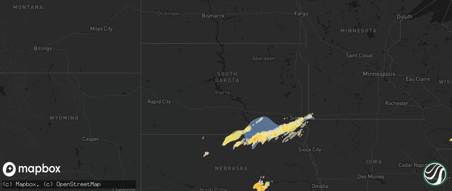
Hail Map in South Dakota on May 17, 2026
The weather event in South Dakota on May 17, 2026 includes Hail, Wind, and Tornado maps. 13 states and 1,536 cities were impacted and suffered possible damage. The total estimated number of properties impacted is 31,855.
Hail
Wind
Tornado
31,855
Estimated number of impacted properties by a 1.00" hail or larger491
Estimated number of impacted properties by a 1.75" hail or larger0
Estimated number of impacted properties by a 2.50" hail or largerStorm reports in South Dakota
South Dakota
| Date | Description |
|---|---|
| 05/17/20265:02 PM CDT | A local report indicates 1.00 inch wind near Valley Springs |
| 05/17/20264:47 PM CDT | A local report indicates 1.50 inch wind near 4 SSE Sioux Falls |
| 05/17/20264:45 PM CDT | Large tree limbs down. |
| 05/17/20264:38 PM CDT | A local report indicates 1.00 inch wind near Tea |
| 05/17/20264:36 PM CDT | Report from 85th and western of quarter size hail. |
| 05/17/20264:32 PM CDT | Report from mping. |
| 05/17/20264:17 PM CDT | Via personal weather station. Exact time estimated via radar. |
| 05/17/20264:17 PM CDT | Quarter size hail along with estimated 40-50 mph winds reported. |
| 05/17/20264:15 PM CDT | 70 mph caused downed tree branches. |
| 05/17/20264:14 PM CDT | Via personal weather station. Exact time estimated via radar. |
| 05/17/20264:09 PM CDT | Power poles snapped and irrigation pivots flipped near the intersection of 276th st and 456th ave. Time estimated from radar. |
| 05/17/20264:06 PM CDT | Video via social media of brief gustnado. Location estimated. |
| 05/17/20263:47 PM CDT | Spotter estimated 50-60 mph winds along with half dollar size hail. |
| 05/17/20263:44 PM CDT | Via mping. Time estimated via radar. |
| 05/17/20263:44 PM CDT | Via mping. Time estimated via radar. |
| 05/17/20263:42 PM CDT | Mesonet station 163 sd rwis freeman. |
| 05/17/20263:42 PM CDT | Damage to large road signs near intersection of hwy 18/81. |
| 05/17/20263:38 PM CDT | Mesonet station mnms2 menno 7ese |
| 05/17/20263:37 PM CDT | Large garage door on outbuilding bowed in. Time estimated from radar. |
| 05/17/20263:36 PM CDT | Corrects time of previous hail report from 3 e menno. Via mping. Time estimated via radar. |
| 05/17/20263:36 PM CDT | Photo of roughly golf ball size hail. Time estimated via radar. |
| 05/17/20263:24 PM CDT | Asos station kmhe mitchell municipal airport. |
| 05/17/20263:16 PM CDT | Via personal weather station. |
| 05/17/20263:15 PM CDT | 65 to 70 mph downed small trees. Quarter sized hail also occurred. |
| 05/17/20263:05 PM CDT | Farm out-buildings severely damaged and 5th wheel camper overturned. |
| 05/17/20263:00 PM CDT | Via personal weather station. Exact time estimated via radar. |
| 05/17/20262:58 PM CDT | Mesonet station avms2 avon 3e |
| 05/17/20262:54 PM CDT | Trained spotter reported a shed with its roof blown off. |
| 05/17/20262:53 PM CDT | Photo of blown in grain bins via em. Time estimated via radar. |
| 05/17/20262:52 PM CDT | Mesonet station 324 sd rwis wagner. |
| 05/17/20262:50 PM CDT | Mesonet station 304 sd rwis corsica. |
| 05/17/20262:50 PM CDT | Mobile trailer flipped... Dismantled... And moved about 60 ft. Pickup truck tipped on its side. Time estimated from radar. |
| 05/17/20262:50 PM CDT | A local report indicates 58 MPH wind near 4 SW Stickney |
| 05/17/20262:48 PM CDT | Awos station kagz wagner. |
| 05/17/20262:48 PM CDT | Broken power poles. Time estimated from radar. |
| 05/17/20262:46 PM CDT | Wind gusts 50-60 mph broke down 1.5 to 2 inch tree branches. Sheets of heavy rain and pea hail were also falling. |
| 05/17/20262:46 PM CDT | Heavily damaged outbuilding. Time estimated from radar. |
| 05/17/20262:44 PM CDT | A mile of power lines down near the intersection of 298th st and 393rd ave. Time estimated from radar. |
| 05/17/20262:40 PM CDT | Via personal weather station. Exact time estimated via radar. |
| 05/17/20262:40 PM CDT | Full trees down along with older farm outbuildings collapsed. Time estimated via radar. |
| 05/17/20262:37 PM CDT | Winds estimated 40-50 mph. |
| 05/17/20262:34 PM CDT | Open front cattle barn and hay shed destroyed. A couple houses in the area also had missing shingles. |
| 05/17/20262:34 PM CDT | Via personal weather station. Exact time estimated via radar. |
| 05/17/20262:30 PM CDT | Mesonet station 244 sd rwis ft. Randall dam. |
| 05/17/20262:07 PM CDT | Via personal weather station. Exact time estimated via radar. |
| 05/17/20261:56 PM CDT | Via personal weather station. Exact time estimated via radar. |
| 05/17/20261:45 PM CDT | Via personal weather station. Exact time estimated via radar. |
| 05/17/20261:40 PM CDT | In addtion to half dollar sized hail... Heavy rain is falling. |
All States Impacted by Hail Map on May 17, 2026
Cities Impacted by Hail Map on May 17, 2026
- Hollandale, WI
- Darlington, WI
- Blanchardville, WI
- Mineral Point, WI
- Mount Horeb, WI
- Barneveld, WI
- Valentine, NE
- Whitman, NE
- Madison, WI
- Verona, WI
- Middleton, WI
- Wood Lake, NE
- Johnstown, NE
- Springview, NE
- Sparks, NE
- Ainsworth, NE
- Winner, SD
- Colome, SD
- Mills, NE
- Dallas, SD
- Long Pine, NE
- Bassett, NE
- Gregory, SD
- Screven, GA
- Burke, SD
- Herrick, SD
- Stuart, NE
- Atkinson, NE
- Eden, WI
- Campbellsport, WI
- Newport, NE
- Lomira, WI
- Naples, FL
- Butte, NE
- Patterson, GA
- Glenbeulah, WI
- Plymouth, WI
- Saint Cloud, WI
- Cascade, WI
- Bristol, GA
- Naper, NE
- Saint Charles, SD
- Spencer, NE
- Oneill, NE
- Fairfax, SD
- Bristow, NE
- Axson, GA
- Pearson, GA
- Estero, FL
- Fort Myers, FL
- Odum, GA
- Platte, SD
- Lynch, NE
- Wagner, SD
- Lake Andes, SD
- Mayo, FL
- Nashville, GA
- Danville, GA
- Irwinton, GA
- Cleveland, WI
- Elkhart Lake, WI
- Nicholls, GA
- Cochran, GA
- Alapaha, GA
- Bonesteel, SD
- Geddes, SD
- Pickstown, SD
- Armour, SD
- Harrison, SD
- Corsica, SD
- Dante, SD
- Avon, SD
- Delmont, SD
- New Holland, SD
- Stickney, SD
- White Lake, SD
- Day, FL
- Franktown, CO
- Douglas, GA
- Ocilla, GA
- Niobrara, NE
- Willacoochee, GA
- Ocklawaha, FL
- McIntyre, GA
- Broxton, GA
- West Green, GA
- Gordon, GA
- Macon, GA
- Springfield, SD
- Elizabeth, CO
- Elbert, CO
- Weirsdale, FL
- Tampa, FL
- Blackshear, GA
- Cape Coral, FL
- Greenville, FL
- Kewaskum, WI
- Adell, WI
- Waldo, WI
- Sheboygan Falls, WI
- Sheboygan, WI
- Newton, WI
- Tripp, SD
- Tyndall, SD
- Scotland, SD
- Uvalda, GA
- Dublin, GA
- Covington, GA
- Rentz, GA
- Baxley, GA
- Immokalee, FL
- Denton, GA
- Haddock, GA
- Lesterville, SD
- Tabor, SD
- Parkston, SD
- Kaylor, SD
- Mount Vernon, SD
- Dimock, SD
- Menno, SD
- Olivet, SD
- Utica, SD
- Irene, SD
- Jonesboro, GA
- McAlpin, FL
- Lake City, FL
- Wellborn, FL
- Milledgeville, GA
- Gray, GA
- Saint Louis, MI
- Madison, FL
- Mount Vernon, GA
- O'Brien, FL
- Alachua, FL
- High Springs, FL
- Trenton, FL
- Atlanta, GA
- Riverdale, GA
- Shepherd, MI
- Viborg, SD
- Freeman, SD
- Hurley, SD
- Marion, SD
- Forest Park, GA
- Wray, GA
- Jacksonville, GA
- McRae Helena, GA
- Ailey, GA
- Fitzgerald, GA
- Stockton, GA
- Lehigh Acres, FL
- Hillsboro, GA
- Newberry, FL
- Breckenridge, MI
- Midland, MI
- Simla, CO
- Emery, SD
- Lake Park, GA
- Juliette, GA
- Mission Hill, SD
- Live Oak, FL
- Hazlehurst, GA
- Milan, GA
- Lake Butler, FL
- Monticello, FL
- Hemlock, MI
- Freeland, MI
- Volin, SD
- Parker, SD
- Bell, FL
- Lumber City, GA
- Du Pont, GA
- Labelle, FL
- Cody, NE
- Glenwood, GA
- Davis, SD
- Tea, SD
- Lennox, SD
- Chancellor, SD
- Sioux Falls, SD
- Harrisburg, SD
- Worthing, SD
- Ravenna, NE
- Bridgewater, SD
- Forsyth, GA
- Matheson, CO
- Limon, CO
- Chauncey, GA
- Eastman, GA
- Soperton, GA
- Rockledge, GA
- Tarrytown, GA
- Rhine, GA
- Brooker, FL
- Alamo, GA
- Monticello, GA
- Flovilla, GA
- Fort White, FL
- Branford, FL
- Saginaw, MI
- University Center, MI
- Bay City, MI
- Crofton, NE
- Lulu, FL
- Inglis, FL
- Bloomfield, NE
- Yankton, SD
- Loup City, NE
- Merrill, MI
- Hahira, GA
- Valdosta, GA
- Ray City, GA
- Boelus, NE
- Rockville, NE
- Cairo, NE
- Dannebrog, NE
- Fordyce, NE
- Gayville, SD
- Naylor, GA
- Genoa, CO
- Ashton, NE
- Essexville, MI
- Munger, MI
- Swainsboro, GA
- Twin City, GA
- Hugo, CO
- Vidalia, GA
- Lyons, GA
- Jenkinsburg, GA
- Locust Grove, GA
- Moody Afb, GA
- Jackson, GA
- Arriba, CO
- Adrian, GA
- Wakonda, SD
- Centerville, SD
- Jasper, FL
- Jennings, FL
- Lebanon, KS
- Esbon, KS
- Canton, SD
- Elba, NE
- Farwell, NE
- Greeley, NE
- Scotia, NE
- Saint Paul, NE
- Fairgrove, MI
- Unionville, MI
- Akron, MI
- Dexter, GA
- Dudley, GA
- Saint Helena, NE
- Vermillion, SD
- Hartford, SD
- East Dublin, GA
- Griffin, GA
- Brandon, SD
- Hawkinsville, GA
- Crystal River, FL
- Larchwood, IA
- Valley Springs, SD
- Beaver Creek, MN
- Hills, MN
- Luverne, MN
- Steen, MN
- Burr Oak, KS
- Beresford, SD
- Seibert, CO
- Flagler, CO
- Caro, MI
- Guide Rock, NE
- Red Cloud, NE
- Wolbach, NE
- Palmer, NE
- Chiefland, FL
- Alcester, SD
- Cordele, GA
- Belgrade, NE
- Vona, CO
- Gagetown, MI
- Inwood, IA
- Mankato, KS
- Sebewaing, MI
- Burbank, SD
- Superior, NE
- Lawrence, NE
- White Springs, FL
- Bunker Hill, KS
- Magnolia, MN
- Fairfield, NE
- Deweese, NE
- Nelson, NE
- Hunter, KS
- Sylvan Grove, KS
- Lucas, KS
- Bad Axe, MI
- Ubly, MI
- Cass City, MI
- Fullerton, NE
- Stratton, CO
- Dorrance, KS
- Archer, NE
- Kanaranzi, MN
- Kenneth, MN
- Rock Valley, IA
- Hudson, SD
- Owendale, MI
- Fairview, SD
- Wrightsville, GA
- Rock Rapids, IA
- Ellsworth, MN
- Cedar Rapids, NE
- Albion, NE
- Central City, NE
- Genoa, NE
- Inland, NE
- Harvard, NE
- Newman Grove, NE
- Bethune, CO
- Adrian, MN
- Edgar, NE
- Saint Edward, NE
- Ruskin, NE
- Russell, KS
- Lecanto, FL
- Homosassa, FL
- Lismore, MN
- Beloit, KS
- Clay Center, NE
- Sutton, NE
- Saronville, NE
- Chapman, NE
- Burlington, CO
- Saint Libory, NE
- Alvord, IA
- Wilmont, MN
- Crystal Springs, MS
- Perry, GA
- Hoisington, KS
- Hardy, NE
- Doon, IA
- Hull, IA
- Terry, MS
- Henderson, NE
- Aurora, NE
- Hampton, NE
- Rushmore, MN
- Minden City, MI
- Elko, GA
- Edgerton, MN
- Thonotosassa, FL
- Zephyrhills, FL
- Deshler, NE
- Webber, KS
- Courtland, KS
- Formoso, KS
- Glen Elder, KS
- Silver Creek, NE
- Lindsay, NE
- Republic, KS
- Byron, NE
- Belleville, KS
- Snover, MI
- Deckerville, MI
- Luray, KS
- Ruth, MI
- Harbor Beach, MI
- Blue Hill, NE
- Kanorado, KS
- Goodland, KS
- Weskan, KS
- Sharon Springs, KS
- Brewster, MN
- Worthington, MN
- Bradshaw, NE
- Monroe, NE
- Humphrey, NE
- Battle Creek, NE
- Madison, NE
- Marquette, NE
- Hordville, NE
- Clarks, NE
- Norfolk, NE
- Platte Center, NE
- Reading, MN
- Jewell, KS
- Westfield, IA
- Akron, IA
- Bigelow, MN
- Sibley, IA
- Giltner, NE
- Byram, MS
- Raymond, MS
- Plant City, FL
- Fulda, MN
- York, NE
- Davenport, NE
- Hebron, NE
- Carleton, NE
- Ashton, IA
- Wesley Chapel, FL
- Millwood, GA
- Little Rock, IA
- George, IA
- Randall, KS
- Hoskins, NE
- Elk Point, SD
- Round Lake, MN
- Okabena, MN
- Lakefield, MN
- Otis, KS
- Albert, KS
- Bison, KS
- Stanton, NE
- Strang, NE
- Le Mars, IA
- Ireton, IA
- Hawarden, IA
- Benedict, NE
- Stromsburg, NE
- Jackson, MS
- Oak, NE
- Belvidere, NE
- Bruning, NE
- Winside, NE
- Columbus, NE
- Polk, NE
- Osceola, NE
- Leigh, NE
- Creston, NE
- Wilson, KS
- Olmitz, KS
- Norway, KS
- Clarkson, NE
- Heron Lake, MN
- Dunnell, MN
- Pilger, NE
- Wayne, NE
- Chester, NE
- Sherburn, MN
- Trimont, MN
- Western, NE
- Bee, NE
- Seward, NE
- Lincoln, KS
- Ceylon, MN
- Wisner, NE
- Edson, KS
- Jackson, MN
- Saint James, MN
- Butterfield, MN
- Ohiowa, NE
- Alexandria, NE
- Odin, MN
- Wakefield, NE
- Emerson, NE
- Pender, NE
- Thurston, NE
- Sheldon, IA
- Valparaiso, NE
- Dwight, NE
- Maurice, IA
- Beemer, NE
- Welcome, MN
- Fairmont, MN
- Mahaska, KS
- Jackson, NE
- Hubbard, NE
- Dahlonega, GA
- Dorchester, NE
- Wilber, NE
- Crete, NE
- Barnard, KS
- Truman, MN
- Dodge, NE
- Howells, NE
- Ormsby, MN
- Pleasant Dale, NE
- Shelby, NE
- Duncan, NE
- Orange City, IA
- Shickley, NE
- Ong, NE
- Fairmont, NE
- Geneva, NE
- Milligan, NE
- Exeter, NE
- Friend, NE
- Cordova, NE
- McCool Junction, NE
- Beaver Crossing, NE
- Lincoln, NE
- Milford, NE
- Denton, NE
- Garland, NE
- Malcolm, NE
- Remsen, IA
- Alton, IA
- Gilead, NE
- Alpha, MN
- Haddam, KS
- Walthill, NE
- Sanborn, IA
- Rush Center, KS
- Larned, KS
- Waterbury, NE
- Endicott, NE
- Fairbury, NE
- Morrowville, KS
- Merrill, IA
- Bancroft, NE
- West Point, NE
- Dakota City, NE
- Windom, MN
- North Sioux City, SD
- Homer, NE
- South Sioux City, NE
- North Bend, NE
- Ceresco, NE
- Raymond, NE
- Davey, NE
- Brunsville, IA
- Prague, NE
- Weston, NE
- Malmo, NE
- Bellwood, NE
- Schuyler, NE
- Winnebago, NE
- Grand Island, NE
- Primrose, NE
- Levant, KS
- Brewster, KS
- Colby, KS
- Beverly, KS
- Minneapolis, KS
- Glasco, KS
- Rising City, NE
- David City, NE
- Mountain Lake, MN
- Winterville, GA
- Washington, KS
- Sioux City, IA
- Hanska, MN
- Simpson, KS
- Tobias, NE
- Granada, MN
- Blue Earth, MN
- Winnebago, MN
- Snyder, NE
- Scribner, NE
- Burdett, KS
- Rozel, KS
- Bingham Lake, MN
- Concordia, KS
- Hooper, NE
- Lewisville, MN
- Nekoma, KS
- Gresham, NE
- Daykin, NE
- Granville, IA
- Macy, NE
- Lyons, NE
- Fremont, NE
- Ithaca, NE
- Wahoo, NE
- Grafton, NE
- Waco, NE
- Salix, IA
- Swanton, NE
- Hallam, NE
- Lawton, IA
- Martell, NE
- Moville, IA
- Colbert, GA
- Rosalie, NE
- Hollenberg, KS
- Waverly, NE
- Yutan, NE
- Ashland, NE
- Mead, NE
- Oakland, NE
- Hinton, IA
- Bronson, IA
- Sergeant Bluff, IA
- Hospers, IA
- Delphos, KS
- Arlington, NE
- Craig, NE
- Herman, NE
- Nickerson, NE
- Sloan, IA
- Decatur, NE
- Walton, NE
- Greenwood, NE
- Murdock, NE
- Eagle, NE
- Louisville, NE
- Alvo, NE
- Elmwood, NE
- Sutherland, IA
- Royal, IA
- Peterson, IA
- Hartley, IA
- Springfield, NE
- Gretna, NE
- South Bend, NE
- Memphis, NE
- Waterloo, NE
- Archer, IA
- Rogers, NE
- Linwood, NE
- Ames, NE
- Morse Bluff, NE
- Cedar Bluffs, NE
- Valley, NE
- Elkhorn, NE
- Sprague, NE
- Roca, NE
- Hickman, NE
- Bennet, NE
- Clatonia, NE
- Omaha, NE
- Cedar Creek, NE
- Plattsmouth, NE
- Bellevue, NE
- Papillion, NE
- Uehling, NE
- Winslow, NE
- New Ulm, MN
- Gibbon, MN
- Madelia, MN
- Vernon Center, MN
- Oyens, IA
- Clyde, KS
- Tescott, KS
- Primghar, IA
- Amboy, MN
- Tekamah, NE
- Melvin, IA
- Diller, NE
- Steele City, NE
- Hanover, KS
- Byers, CO
- Whiting, IA
- Onawa, IA
- Kingsley, IA
- Climbing Hill, IA
- Hornick, IA
- Anthon, IA
- Pierson, IA
- Correctionville, IA
- Marcus, IA
- Colon, NE
- Palmyra, NE
- Cleghorn, IA
- Modale, IA
- Washta, IA
- Moorhead, IA
- Little Sioux, IA
- Mapleton, IA
- Soldier, IA
- Smithland, IA
- Bennington, NE
- Oto, IA
- Crescent, IA
- Kennard, NE
- La Vista, NE
- Pisgah, IA
- Blencoe, IA
- Boys Town, NE
- Blair, NE
- Fort Calhoun, NE
- Rodney, IA
- Castana, IA
- Washington, NE
- Mondamin, IA
- Missouri Valley, IA
- Meriden, IA
- Weeping Water, NE
- Manley, NE
- De Witt, NE
- Offutt Afb, NE
- Silver City, IA
- Carter Lake, IA
- Ute, IA
- McClelland, IA
- Council Bluffs, IA
- Logan, IA
- Danbury, IA
- Honey Creek, IA
- Pacific Junction, IA
- Underwood, IA
- Mineola, IA
- Glenwood, IA
- Woodbine, IA
- Neola, IA
- Magnolia, IA
- Dunlap, IA
- Miltonvale, KS
- Paullina, IA
- Lake Crystal, MN
- Adams, NE
- Cortland, NE
- Firth, NE
- Panama, NE
- Lafayette, MN
- Unadilla, NE
- Douglas, NE
- Winthrop, MN
- Calumet, IA
- Quimby, IA
- Murray, NE
- Nehawka, NE
- Syracuse, NE
- Avoca, NE
- Otoe, NE
- Holstein, IA
- Larrabee, IA
- Ricketts, IA
- Dow City, IA
- Ida Grove, IA
- Battle Creek, IA
- Persia, IA
- Portsmouth, IA
- Cherokee, IA
- Schleswig, IA
- Cushing, IA
- Treynor, IA
- Charter Oak, IA
- Aurelia, IA
- Galva, IA
- Denison, IA
- Everly, IA
- Pickrell, NE
- Bennington, KS
- Aurora, KS
- Linn, KS
- Agenda, KS
- Clifton, KS
- Palmer, KS
- Clay Center, KS
- Morganville, KS
- Mapleton, MN
- Longford, KS
- Wakefield, KS
- Solomon, KS
- Abilene, KS
- Thurman, IA
- Sterling, NE
- Cook, NE
- Tecumseh, NE
- Burr, NE
- Talmage, NE
- Lorton, NE
- Nebraska City, NE
- Union, NE
- Dunbar, NE
- Odell, NE
- Alta, IA
- Storm Lake, IA
- Sioux Rapids, IA
- Arnolds Park, IA
- Shelby, IA
- Odebolt, IA
- Minden, IA
- Fostoria, IA
- Schaller, IA
- Greenville, IA
- Arion, IA
- Spencer, IA
- Linn Grove, IA
- Arthur, IA
- Rembrandt, IA
- Kiron, IA
- Earling, IA
- Milford, IA
- Panama, IA
- Spirit Lake, IA
- Okoboji, IA
- Ocheyedan, IA
- Greenleaf, KS
- Green, KS
- Barnes, KS
- Wymore, NE
- Bremen, KS
- Alexander, KS
- Garden City, MN
- Delavan, MN
- Lake Park, IA
- Harris, IA
- Percival, IA
- Manilla, IA
- Harlan, IA
- Emerson, IA
- Tabor, IA
- Oakland, IA
- Malvern, IA
- Early, IA
- Farragut, IA
- Defiance, IA
- Johnson, NE
- Macedonia, IA
- Deloit, IA
- Hamburg, IA
- Westphalia, IA
- Avoca, IA
- Truesdale, IA
- Hastings, IA
- Randolph, IA
- Hancock, IA
- Henderson, IA
- Brock, NE
- Carson, IA
- Sidney, IA
- Imogene, IA
- Albert City, IA
- Marathon, IA
- Good Thunder, MN
- Filley, NE
- Beatrice, NE
- Blue Springs, NE
- Virginia, NE
- Crab Orchard, NE
- Dickens, IA
- Gillett Grove, IA
- Vail, IA
- Nemaha, IA
- Webb, IA
- Irwin, IA
- Wall Lake, IA
- Superior, IA
- Estherville, IA
- Terril, IA
- Kirkman, IA
- Pocahontas, IA
- Laurens, IA
- Havelock, IA
- Pomeroy, IA
- Peru, NE
- Riverton, IA
- Julian, NE
- Auburn, NE
- Rock Port, MO
- Garretson, SD
- Boyden, IA
- Liberty, NE
- Burchard, NE
- Lewiston, NE
- Ness City, KS
- Lester, IA
- La Crosse, KS
- Claflin, KS
- Ruthven, IA
- Mankato, MN
- Randolph, KS
- Marysville, KS
- Oketo, KS
- Waterville, KS
- Barneston, NE
- Riley, KS
- Leonardville, KS
- Blue Rapids, KS
- Lake View, IA
- Newell, IA
- Armstrong, IA
- Ellsworth, KS
- Emmetsburg, IA
- Graettinger, IA
- Rockwell City, IA
- Taopi, MN
- Le Roy, MN
- Ayrshire, IA
- Jetmore, KS
- Home, KS
- Elk Creek, NE
- Pawnee City, NE
- Beattie, KS
- Frankfort, KS
- Milford, KS
- Summerfield, KS
- Steinauer, NE
- Manhattan, KS
- Junction City, KS
- Fort Riley, KS
- Chapman, KS
- Olsburg, KS
- Watson, MO
- Red Oak, IA
- Breda, IA
- Kimballton, IA
- Manning, IA
- Walnut, IA
- Elliott, IA
- Shenandoah, IA
- Lewis, IA
- Marne, IA
- Essex, IA
- Elk Horn, IA
- Atlantic, IA
- Sac City, IA
- Aspinwall, IA
- Audubon, IA
- Arcadia, IA
- Coin, IA
- Westside, IA
- Griswold, IA
- Auburn, IA
- Templeton, IA
- Mallard, IA
- Exira, IA
- Stanton, IA
- Carroll, IA
- Varina, IA
- Clarinda, IA
- Ringsted, IA
- Halbur, IA
- Gray, IA
- Wallingford, IA
- Dolliver, IA
- Jolley, IA
- Curlew, IA
- Lytton, IA
- Brayton, IA
- Fonda, IA
- Lake City, IA
- Cylinder, IA
- Clare, IA
- Swea City, IA
- Glidden, IA
- Villisca, IA
- Elmore, MN
- Lakota, IA
- Scranton, IA
- Algona, IA
- Fort Dodge, IA
- Lone Rock, IA
- Ottosen, IA
- Corwith, IA
- Barnum, IA
- Anita, IA
- Manson, IA
- Churdan, IA
- Dedham, IA
- Lidderdale, IA
- Wiota, IA
- Humboldt, IA
- Grant, IA
- Buffalo Center, IA
- Wesley, IA
- Rutland, IA
- Ralston, IA
- Moorland, IA
- Dakota City, IA
- Bancroft, IA
- Knierim, IA
- West Bend, IA
- Gowrie, IA
- Titonka, IA
- Hardy, IA
- Plover, IA
- Fenton, IA
- Burt, IA
- Badger, IA
- Bradgate, IA
- Guthrie Center, IA
- Forest City, IA
- Lanesboro, IA
- Woden, IA
- Britt, IA
- Whittemore, IA
- Coon Rapids, IA
- Callender, IA
- Lohrville, IA
- Ledyard, IA
- Jefferson, IA
- Gilmore City, IA
- Bayard, IA
- Farnhamville, IA
- Somers, IA
- Lu Verne, IA
- Palmer, IA
- Cumberland, IA
- Renwick, IA
- Rolfe, IA
- Bode, IA
- Hamlin, IA
- Adair, IA
- Livermore, IA
- Elkton, MN
- Lindon, CO
- Cimarron, KS
- Westmoreland, KS
- Vermillion, KS
- Baileyville, KS
- Axtell, KS
- Humboldt, NE
- Table Rock, NE
- Du Bois, NE
- Seneca, KS
- Saint George, KS
- Wamego, KS
- Ogden, KS
- Centralia, KS
- Onaga, KS
- Bern, KS
- Salina, KS
- New Cambria, KS
- Talmage, KS
- Alma, KS
- Corning, KS
- Nodaway, IA
- New Market, IA
- Corning, IA
- Carbon, IA
- Casey, IA
- Massena, IA
- Gravity, IA
- Dana, IA
- Fontanelle, IA
- Goldfield, IA
- Paton, IA
- Yorktown, IA
- Thor, IA
- Bridgewater, IA
- Panora, IA
- Bagley, IA
- Otho, IA
- Bedford, IA
- Prescott, IA
- Yale, IA
- Vincent, IA
- Glenville, MN
- Ogden, IA
- Dayton, IA
- Rippey, IA
- Goodell, IA
- Crystal Lake, IA
- Burnside, IA
- Webster City, IA
- Wells, MN
- Harcourt, IA
- Lehigh, IA
- Conger, MN
- Northwood, IA
- Emmons, MN
- Klemme, IA
- Garner, IA
- Lake Mills, IA
- Fertile, IA
- Thompson, IA
- Dawson, IA
- Clear Lake, IA
- Eagle Grove, IA
- Duncombe, IA
- Orient, IA
- Frost, MN
- Alden, MN
- Ventura, IA
- Scarville, IA
- Kanawha, IA
- Joice, IA
- Bricelyn, MN
- Woolstock, IA
- Jamaica, IA
- Clarion, IA
- Pilot Mound, IA
- Twin Lakes, MN
- Belmond, IA
- Grand Junction, IA
- Hayward, MN
- Kiester, MN
- Greenfield, IA
- Leland, IA
- Albert Lea, MN
- Beaver, IA
- Rake, IA
- Boxholm, IA
- Stuart, IA
- Menlo, IA
- Brownville, NE
- Mason City, IA
- Spring Valley, MN
- Greenwood, WI
- Neillsville, WI
- New Richland, MN
- Freeborn, MN
- Hartland, MN
- Easton, MN
- Minnesota Lake, MN
- Waldorf, MN
- Ellendale, MN
- Owatonna, MN
- Waseca, MN
- Fairfax, MO
- Goff, KS
- Hanston, KS
- Clarks Grove, MN
- Morrill, KS
- Falls City, NE
- Shubert, NE
- Salem, NE
- Sabetha, KS
- Havensville, KS
- Belvue, KS
- Verdon, NE
- Nemaha, NE
- Tarkio, MO
- Oneida, KS
- Stella, NE
- Dawson, NE
- Westboro, MO
- Northboro, IA
- McFarland, KS
- Circleville, KS
- Saint Marys, KS
- Hiawatha, KS
- Paxico, KS
- Soldier, KS
- Delia, KS
- Holton, KS
- Maple Hill, KS
- Fairview, KS
- Wetmore, KS
- Emmett, KS
- Powhattan, KS
- Netawaka, KS
- Janesville, MN
- Holyrood, KS
- Loyal, WI
- Blooming Prairie, MN
- Kenyon, MN
- Medford, MN
- Geneva, MN
- Hope, MN
- West Concord, MN
- Claremont, MN
- Faribault, MN
- Hollandale, MN
- Wanamingo, MN
- Thornton, IA
- Dodge Center, MN
- Kensett, IA
- Perry, IA
- Stratford, IA
- Linden, IA
- Manly, IA
- Boone, IA
- Hanlontown, IA
- Pine Island, MN
- Hayfield, MN
- Zumbrota, MN
- Austin, MN
- Creston, IA
- Minburn, IA
- Galt, IA
- Kamrar, IA
- Blairsburg, IA
- Cromwell, IA
- Meservey, IA
- Stanhope, IA
- Woodward, IA
- Rowan, IA
- Clearfield, IA
- Redfield, IA
- Sharpsburg, IA
- Lenox, IA
- Adel, IA
- Bouton, IA
- Dexter, IA
- Alexander, IA
- Dows, IA
- Dexter, MN
- Grand Meadow, MN
- Lorraine, KS
- Craig, MO
- Mayetta, KS
- Hoyt, KS
- Horton, KS
- Rossville, KS
- Topeka, KS
- Silver Lake, KS
- Whiting, KS
- Rulo, NE
- Valley Falls, KS
- Denison, KS
- Meriden, KS
- White Cloud, KS
- Muscotah, KS
- Pickering, MO
- Maryville, MO
- Fillmore, MO
- Highland, KS
- Braddyville, IA
- Burlington Junction, MO
- Everest, KS
- Skidmore, MO
- Mound City, MO
- Maitland, MO
- Bolckow, MO
- Hopkins, MO
- Clearmont, MO
- Barnard, MO
- Oregon, MO
- Elmo, MO
- Robinson, KS
- Troy, KS
- Blanchard, IA
- Denton, KS
- Lancaster, KS
- Effingham, KS
- Forest City, MO
- Graham, MO
- Sheridan, MO
- College Springs, IA
- Shambaugh, IA
- Gentry, MO
- Denver, MO
- Albany, MO
- Savannah, MO
- Conception Junction, MO
- Nortonville, KS
- Worth, MO
- Conception, MO
- Stanberry, MO
- Atchison, KS
- Ravenwood, MO
- Grant City, MO
- Blockton, IA
- Guilford, MO
- Amazonia, MO
- King City, MO
- Clyde, MO
- Parnell, MO
- Rosendale, MO
- Rea, MO
- Bendena, KS
- Wathena, KS
- Kellerton, IA
- Saint Charles, IA
- Lyle, MN
- Polk City, IA
- Dallas Center, IA
- West Des Moines, IA
- Grimes, IA
- Popejoy, IA
- Alden, IA
- Madrid, IA
- Benton, IA
- Earlham, IA
- Van Meter, IA
- De Soto, IA
- Randall, IA
- Swaledale, IA
- Ellsworth, IA
- Slater, IA
- Cumming, IA
- Radcliffe, IA
- Winterset, IA
- Grafton, IA
- Mount Ayr, IA
- Story City, IA
- Booneville, IA
- Jewell, IA
- Murray, IA
- Coulter, IA
- Waltham, MN
- Rockwell, IA
- Johnston, IA
- Clive, IA
- Gilbert, IA
- Saint Ansgar, IA
- Thayer, IA
- Urbandale, IA
- Macksburg, IA
- Sheffield, IA
- Tingley, IA
- Hatfield, MO
- Ames, IA
- Luther, IA
- Latimer, IA
- Diagonal, IA
- Granger, IA
- Lansing, MN
- Hampton, IA
- Redding, IA
- Waukee, IA
- Kelley, IA
- Lorimor, IA
- Williams, IA
- Peru, IA
- Shannon City, IA
- Ellston, IA
- Afton, IA
- Black River Falls, WI
- Pawnee Rock, KS
- Kanopolis, KS
- Hixton, WI
- Union Star, MO
- Rushville, MO
- Helena, MO
- Elwood, KS
- Darlington, MO
- Saint Joseph, MO
- Cosby, MO
- Cummings, KS
- Alma Center, WI
- Merrillan, WI
- Melrose, WI
- Melbourne, IA
- Elkhart, IA
- Truro, IA
- Rockford, IA
- New Providence, IA
- Allison, IA
- Martensdale, IA
- Bradford, IA
- Saint Anthony, IA
- Mantorville, MN
- Hubbard, IA
- Des Moines, IA
- Wellsburg, IA
- Mitchellville, IA
- Grand River, IA
- Rock Falls, IA
- Nora Springs, IA
- Cambridge, IA
- Nevada, IA
- Garden City, IA
- Berwick, IA
- Marble Rock, IA
- Indianola, IA
- Alleman, IA
- Sargeant, MN
- Carpenter, IA
- Osceola, IA
- Huxley, IA
- Aredale, IA
- State Center, IA
- Mingo, IA
- Iowa Falls, IA
- Saint Marys, IA
- Chapin, IA
- Runnells, IA
- Zearing, IA
- Clemons, IA
- Baxter, IA
- Colfax, IA
- Brownsdale, MN
- Altoona, IA
- Marshalltown, IA
- Rose Creek, MN
- Collins, IA
- Bevington, IA
- Rudd, IA
- Steamboat Rock, IA
- Grundy Center, IA
- New Virginia, IA
- Sheldahl, IA
- Ackley, IA
- Dumont, IA
- Prole, IA
- Whitten, IA
- Kasson, MN
- McCallsburg, IA
- Patterson, IA
- Osage, IA
- Conrad, IA
- Bondurant, IA
- Albion, IA
- Greene, IA
- Carlisle, IA
- Roland, IA
- Austinville, IA
- Eldora, IA
- Plymouth, IA
- Windsor Heights, IA
- Union, IA
- Pleasant Hill, IA
- Norwalk, IA
- Geneva, IA
- Colo, IA
- Liscomb, IA
- Dougherty, IA
- Bristow, IA
- Rhodes, IA
- Ankeny, IA
- Aplington, IA
- Maxwell, IA
- Humbird, WI
- Hartford, IA
- Ira, IA
- Van Wert, IA
- Lamoni, IA
- Ackworth, IA
- Great Bend, KS
- Brookville, KS
- Augusta, WI
- Turtle Lake, WI
- Stewartville, MN
- Kesley, IA
- Adams, MN
- Little Cedar, IA
- Byron, MN
- Orchard, IA
- Stacyville, IA
- Floyd, IA
- Charles City, IA
- Riceville, IA
- Eyota, MN
- Mazeppa, MN
- Clarksville, IA
- Racine, MN
- Zumbro Falls, MN
- McIntire, IA
- Chester, IA
- Oronoco, MN
- Elgin, MN
- Ostrander, MN
- Rochester, MN
- Parkersburg, IA
- Elma, IA
- Colwell, IA
- Alta Vista, IA
- Wykoff, MN
- Lime Springs, IA
- Holland, IA
- Nashua, IA
- Shell Rock, IA
- Harmony, MN
- Preston, MN
- Chatfield, MN
- Ionia, IA
- New Hartford, IA
- Plainfield, IA
- New Hampton, IA
- Newton, IA
- Dike, IA
- Waverly, IA
- Prairie City, IA
- Stout, IA
- Beaman, IA
- Milo, IA
- Laurel, IA
- Swan, IA
- Haverhill, IA
- Lucas, IA
- Woodburn, IA
- Pleasantville, IA
- Monroe, IA
- Gladbrook, IA
- Reinbeck, IA
- Cedar Falls, IA
- Cresco, IA
- Enterprise, KS
- Medford, WI
- Stetsonville, WI
- Hope, KS
- Athens, WI
- Rib Lake, WI
- Geneseo, KS
- Harshaw, WI
- Rhinelander, WI
- Bushton, KS
- Meeker, CO
- Agate, CO
- Three Lakes, WI
- Eagle River, WI
- Argonne, WI
- Davenport, IA
- Rock Island, IL
- Milan, IL
- Crystal Falls, MI
- Tipton, KS
- Michigamme, MI
- Eldridge, IA
- Bettendorf, IA
- Amasa, MI
- Republic, MI
- Champion, MI
- Camanche, IA
- Princeton, IA
- East Moline, IL
- Pleasant Valley, IA
- Moline, IL
- Hampton, IL
- Clinton, IA
- Le Claire, IA
- Taylor Ridge, IL
- Channing, MI
- Reynolds, IL
- Coal Valley, IL
- Sagola, MI
- Long Grove, IA
- Mount Carroll, IL
- Savanna, IL
- Geneseo, IL
- Colona, IL
- Felch, MI
- Blue Grass, IA
- McCausland, IA
- Andalusia, IL
- Oquawka, IL
- Sherrard, IL
- Aledo, IL
- Erie, IL
- Hillsdale, IL
- Orion, IL
- Darien, WI
- Delavan, WI
- Sharon, WI
- Elkhorn, WI
- Tiskilwa, IL
- Princeton, IL
- Montrose, GA
- Cordova, IL
- Gibbs, MO
- Brashear, MO
- Kirksville, MO
- Hurdland, MO
- La Plata, MO
- Chilton, WI
- Malone, WI
- Mount Calvary, WI
- Fond Du Lac, WI
- Kiel, WI
- Valders, WI
- New Holstein, WI
- Onekama, MI
- Bear Lake, MI
- Lynd, MN
- Tyler, MN
- Russell, MN
- Balaton, MN
- Ruthton, MN
- Wallace, KS
- Winona, KS


