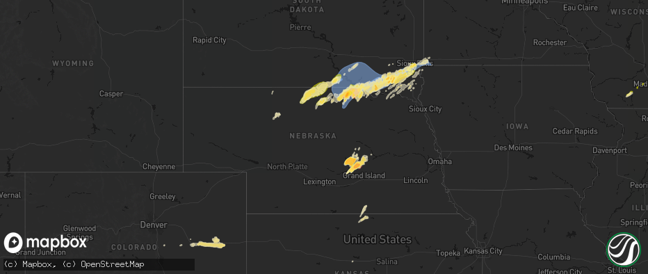
Hail Map in Nebraska on May 17, 2026
The weather event in Nebraska on May 17, 2026 includes Hail, Wind, and Tornado maps. 13 states and 1,536 cities were impacted and suffered possible damage. The total estimated number of properties impacted is 31,039.
Hail
Wind
Tornado
31,039
Estimated number of impacted properties by a 1.00" hail or larger14,543
Estimated number of impacted properties by a 1.75" hail or larger4,751
Estimated number of impacted properties by a 2.50" hail or largerStorm reports in Nebraska
Nebraska
| Date | Description |
|---|---|
| 05/17/20266:59 PM CDT | A local report indicates 1.75 inch wind near 2 SW Wisner |
| 05/17/20266:57 PM CDT | A local report indicates 1.00 inch wind near Wisner |
| 05/17/20266:53 PM CDT | Tight circulation and tds evident. |
| 05/17/20266:43 PM CDT | Family member of nws employee. |
| 05/17/20266:37 PM CDT | Public weather station. |
| 05/17/20266:36 PM CDT | Corrects previous hail report from clarkson. |
| 05/17/20266:36 PM CDT | A local report indicates 1.00 inch wind near Clarkson |
| 05/17/20266:35 PM CDT | Large tree down in friend. |
| 05/17/20266:34 PM CDT | A local report indicates 2.50 inch wind near Deshler |
| 05/17/20266:33 PM CDT | A local report indicates 67 MPH wind near 2 WSW Bruning |
| 05/17/20266:33 PM CDT | A local report indicates 1.00 inch wind near Clarks |
| 05/17/20266:30 PM CDT | Facebook photo of estimated hail larger than 2 inches. |
| 05/17/20266:30 PM CDT | Image sent in of 2 hail. |
| 05/17/20266:29 PM CDT | Public weather station. |
| 05/17/20266:25 PM CDT | A local report indicates 59 MPH wind near 9 WNW Genoa |
| 05/17/20266:20 PM CDT | Personal weather station. |
| 05/17/20266:19 PM CDT | A local report indicates 1.00 inch wind near Central City |
| 05/17/20266:15 PM CDT | A local report indicates 58 MPH wind near 3 ENE Geneva |
| 05/17/20266:15 PM CDT | Report from mping: ping pong ball |
| 05/17/20266:14 PM CDT | Nebraska mesonet. |
| 05/17/20266:14 PM CDT | Corrects previous tstm wnd gst report from 5 s monroe. Nebraska mesonet. |
| 05/17/20266:12 PM CDT | Reports of downed power lines. |
| 05/17/20266:10 PM CDT | A local report indicates 1.00 inch wind near Byron |
| 05/17/20266:08 PM CDT | A local report indicates 58 MPH wind near 4 S Geneva |
| 05/17/20266:08 PM CDT | Powerlines down. |
| 05/17/20266:06 PM CDT | A local report indicates 1.50 inch wind near 3 SW Henderson |
| 05/17/20266:06 PM CDT | (gid |
| 05/17/20266:05 PM CDT | Personal weather station. |
| 05/17/20266:01 PM CDT | A local report indicates 59 MPH wind near 3 N Genoa |
| 05/17/20266:00 PM CDT | A local report indicates 74 MPH wind near 2 W Central City |
| 05/17/20266:00 PM CDT | A local report indicates 1.75 inch wind near Fullerton |
| 05/17/20265:52 PM CDT | A local report indicates 59 MPH wind near 9 WNW Genoa |
| 05/17/20265:47 PM CDT | Pea to dime sized hail... 50-60 mph winds. |
| 05/17/20265:43 PM CDT | A local report indicates 1.50 inch wind near 1 S Deweese |
| 05/17/20265:43 PM CDT | A local report indicates 1.50 inch wind near 3 SSE Deweese |
| 05/17/20265:40 PM CDT | A local report indicates 1.75 inch wind near 1 N Superior |
| 05/17/20265:39 PM CDT | A local report indicates 61 MPH wind near 5 N Palmer |
| 05/17/20265:36 PM CDT | A local report indicates 1.75 inch wind near 2 W Superior |
| 05/17/20265:35 PM CDT | A local report indicates 60 MPH wind near 3 NNW Oak |
| 05/17/20265:32 PM CDT | Corrects previous tstm wnd gst report from 5 n palmer. |
| 05/17/20265:30 PM CDT | A local report indicates 60 MPH wind near 3 WSW Oak |
| 05/17/20265:27 PM CDT | A local report indicates 1.75 inch wind near 5 N Guide Rock |
| 05/17/20265:27 PM CDT | A local report indicates 3.00 inch wind near 1 NE Dannebrog |
| 05/17/20265:25 PM CDT | A local report indicates 3.50 inch wind near 1 W Palmer |
| 05/17/20265:18 PM CDT | A local report indicates 63 MPH wind near 5 W Palmer |
| 05/17/20265:17 PM CDT | A local report indicates 64 MPH wind near 3 SSE Fairmont |
| 05/17/20265:15 PM CDT | A local report indicates 2.50 inch wind near 5 ESE Saint Paul |
| 05/17/20265:14 PM CDT | A local report indicates 1.50 inch wind near Saint Paul |
| 05/17/20265:12 PM CDT | A local report indicates a tornado near 7 N Saint Libory |
| 05/17/20265:11 PM CDT | A local report indicates 2.75 inch wind near Dannebrog |
| 05/17/20265:10 PM CDT | Damage to structures reported. |
| 05/17/20265:09 PM CDT | A local report indicates a tornado near 4N Saint Libory |
| 05/17/20265:04 PM CDT | A local report indicates a tornado near 2 W Saint Libory |
| 05/17/20265:04 PM CDT | A local report indicates 2.75 inch wind near Dannebrog |
| 05/17/20264:58 PM CDT | Corrects previous hail report from 1 ne dannebrog. |
| 05/17/20264:58 PM CDT | Corrects previous hail report from dannebrog. |
| 05/17/20264:56 PM CDT | A local report indicates 1.00 inch wind near 1 N Elba |
| 05/17/20264:54 PM CDT | A local report indicates 2.75 inch wind near Elba |
| 05/17/20264:52 PM CDT | Report from mping: golf ball |
| 05/17/20264:51 PM CDT | Danny near ashton. |
| 05/17/20264:51 PM CDT | A local report indicates a tornado near 4 NNE Cairo |
| 05/17/20264:50 PM CDT | A local report indicates 2.00 inch wind near 3 ENE Ashton |
| 05/17/20264:44 PM CDT | A local report indicates 1.75 inch wind near Dannebrog |
| 05/17/20264:43 PM CDT | A local report indicates 3.00 inch wind near Ashton |
| 05/17/20264:35 PM CDT | A local report indicates 1.75 inch wind near 3.5 WSW Ashton |
| 05/17/20264:34 PM CDT | A local report indicates 1.75 inch wind near Boelus |
| 05/17/20264:30 PM CDT | A local report indicates 2.50 inch wind near Ashton |
| 05/17/20264:14 PM CDT | A local report indicates 1.00 inch wind near 3 SE Ravenna |
| 05/17/20262:15 PM CDT | A local report indicates 77 MPH wind near 2 SE Spencer |
| 05/17/20262:15 PM CDT | Roof partially blowm off a gas station. Several large tree branches down. |
| 05/17/20262:08 PM CDT | A local report indicates 64 MPH wind near 3 SW Spencer |
| 05/17/20261:45 PM CDT | Wind gusts from 50 to 60 mph. |
| 05/17/20261:19 PM CDT | Lots of hail up to nickel size. Damaging to the house siding and shredded tree leaves. |
| 05/17/20261:00 PM CDT | Corrects previous thunderstorm wind gust report from 5 miles west of burton. |
| 05/17/20261:00 PM CDT | A local report indicates 60 MPH wind near 11 ESE Sparks |
| 05/16/20269:55 PM CDT | Personal weather station gusted to 59 mph 2 miles wnw of humboldt... Ne. |
| 05/16/20269:42 PM CDT | Personal weather station measured 60 mph. |
| 05/16/20269:37 PM CDT | Personal weather station. |
| 05/16/20269:30 PM CDT | Personal weather station. |
| 05/16/20269:04 PM CDT | Report of quarter sized hail in avoca... Relayed via nwschat by em. |
| 05/16/20268:46 PM CDT | Report of damage to homes south of plattsmouth from possible tornado. Additional chaser photo of possible tornado in the same area. Time is estimated. |
| 05/16/20268:44 PM CDT | Trained weather spotter reported estimated 60 mph wind gusts along with pea size hail. |
| 05/16/20268:42 PM CDT | Personal weather station. |
| 05/16/20268:37 PM CDT | Spotter report of 60 to 70 mph estimated wind gusts. |
| 05/16/20268:27 PM CDT | Asos koma reporting peak gust of 63 mph at 827pm. |
| 05/16/20268:26 PM CDT | Personal weather station. |
| 05/16/20268:21 PM CDT | Tree branches down with damage to a street light. Time is estimated from radar. |
| 05/16/20268:21 PM CDT | Public photo of broken tree branch approximately 4 inches in diameter. Time is estimated from radar. |
| 05/16/20268:15 PM CDT | A local report indicates 58 MPH wind near 3 SE Firth |
| 05/16/20268:15 PM CDT | A local report indicates 70 MPH wind near 4 NW Waverly |
| 05/16/20268:14 PM CDT | Downed tree branches resulted in rain gutter being partially torn off a home. Time is estimated from radar. |
| 05/16/20268:10 PM CDT | A few tree tops gone. Tree branches flying/fallen. |
| 05/16/20268:01 PM CDT | Report from mping: quarter |
| 05/16/20267:55 PM CDT | Large trees and limbs down on roads. Time is estimated. |
| 05/16/20267:54 PM CDT | Asos station klnk lincoln airport. |
| 05/16/20267:50 PM CDT | Personal weather station. |
| 05/16/20267:44 PM CDT | Awos station kfet fremont airport. |
| 05/16/20267:44 PM CDT | Personal weather station gust to 66 mph. |
| 05/16/20267:31 PM CDT | Em estimated 60+ mph winds in lincoln. |
| 05/16/20267:30 PM CDT | Personal weather station. |
| 05/16/20267:28 PM CDT | Personal weather station. |
| 05/16/20267:28 PM CDT | Estimating half dollar. |
| 05/16/20267:27 PM CDT | Personal weather station. |
| 05/16/20267:26 PM CDT | A local report indicates 60 MPH wind near Strang |
| 05/16/20267:21 PM CDT | Wind damage in winnebago and points south. Trees down. Possible tornado damage. |
| 05/16/20267:21 PM CDT | A local report indicates 60 MPH wind near 3 E Strang |
| 05/16/20267:20 PM CDT | Image sent in over social media. |
| 05/16/20267:20 PM CDT | Widespread tree branches down... 5 inch diameter. Time is estimated. |
| 05/16/20267:16 PM CDT | A local report indicates 1.00 inch wind near Pender |
| 05/16/20267:16 PM CDT | Estimated wind speeds. |
| 05/16/20267:15 PM CDT | Personal weather station. |
| 05/16/20267:14 PM CDT | Upr station. |
| 05/16/20267:10 PM CDT | Report on social media of a tree knocked over tree. |
| 05/16/20267:09 PM CDT | Power is out in bancroft. |
| 05/16/20267:07 PM CDT | A local report indicates 58 MPH wind near 4 NNW Ohiowa |
| 05/16/20267:02 PM CDT | Had many reports of 3/4 inch mixed in with the inch hail. |
All States Impacted by Hail Map on May 17, 2026
Cities Impacted by Hail Map on May 17, 2026
- Hollandale, WI
- Darlington, WI
- Blanchardville, WI
- Mineral Point, WI
- Mount Horeb, WI
- Barneveld, WI
- Valentine, NE
- Whitman, NE
- Madison, WI
- Verona, WI
- Middleton, WI
- Wood Lake, NE
- Johnstown, NE
- Springview, NE
- Sparks, NE
- Ainsworth, NE
- Winner, SD
- Colome, SD
- Mills, NE
- Dallas, SD
- Long Pine, NE
- Bassett, NE
- Gregory, SD
- Screven, GA
- Burke, SD
- Herrick, SD
- Stuart, NE
- Atkinson, NE
- Eden, WI
- Campbellsport, WI
- Newport, NE
- Lomira, WI
- Naples, FL
- Butte, NE
- Patterson, GA
- Glenbeulah, WI
- Plymouth, WI
- Saint Cloud, WI
- Cascade, WI
- Bristol, GA
- Naper, NE
- Saint Charles, SD
- Spencer, NE
- Oneill, NE
- Fairfax, SD
- Bristow, NE
- Axson, GA
- Pearson, GA
- Estero, FL
- Fort Myers, FL
- Odum, GA
- Platte, SD
- Lynch, NE
- Wagner, SD
- Lake Andes, SD
- Mayo, FL
- Nashville, GA
- Danville, GA
- Irwinton, GA
- Cleveland, WI
- Elkhart Lake, WI
- Nicholls, GA
- Cochran, GA
- Alapaha, GA
- Bonesteel, SD
- Geddes, SD
- Pickstown, SD
- Armour, SD
- Harrison, SD
- Corsica, SD
- Dante, SD
- Avon, SD
- Delmont, SD
- New Holland, SD
- Stickney, SD
- White Lake, SD
- Day, FL
- Franktown, CO
- Douglas, GA
- Ocilla, GA
- Niobrara, NE
- Willacoochee, GA
- Ocklawaha, FL
- McIntyre, GA
- Broxton, GA
- West Green, GA
- Gordon, GA
- Macon, GA
- Springfield, SD
- Elizabeth, CO
- Elbert, CO
- Weirsdale, FL
- Tampa, FL
- Blackshear, GA
- Cape Coral, FL
- Greenville, FL
- Kewaskum, WI
- Adell, WI
- Waldo, WI
- Sheboygan Falls, WI
- Sheboygan, WI
- Newton, WI
- Tripp, SD
- Tyndall, SD
- Scotland, SD
- Uvalda, GA
- Dublin, GA
- Covington, GA
- Rentz, GA
- Baxley, GA
- Immokalee, FL
- Denton, GA
- Haddock, GA
- Lesterville, SD
- Tabor, SD
- Parkston, SD
- Kaylor, SD
- Mount Vernon, SD
- Dimock, SD
- Menno, SD
- Olivet, SD
- Utica, SD
- Irene, SD
- Jonesboro, GA
- McAlpin, FL
- Lake City, FL
- Wellborn, FL
- Milledgeville, GA
- Gray, GA
- Saint Louis, MI
- Madison, FL
- Mount Vernon, GA
- O'Brien, FL
- Alachua, FL
- High Springs, FL
- Trenton, FL
- Atlanta, GA
- Riverdale, GA
- Shepherd, MI
- Viborg, SD
- Freeman, SD
- Hurley, SD
- Marion, SD
- Forest Park, GA
- Wray, GA
- Jacksonville, GA
- McRae Helena, GA
- Ailey, GA
- Fitzgerald, GA
- Stockton, GA
- Lehigh Acres, FL
- Hillsboro, GA
- Newberry, FL
- Breckenridge, MI
- Midland, MI
- Simla, CO
- Emery, SD
- Lake Park, GA
- Juliette, GA
- Mission Hill, SD
- Live Oak, FL
- Hazlehurst, GA
- Milan, GA
- Lake Butler, FL
- Monticello, FL
- Hemlock, MI
- Freeland, MI
- Volin, SD
- Parker, SD
- Bell, FL
- Lumber City, GA
- Du Pont, GA
- Labelle, FL
- Cody, NE
- Glenwood, GA
- Davis, SD
- Tea, SD
- Lennox, SD
- Chancellor, SD
- Sioux Falls, SD
- Harrisburg, SD
- Worthing, SD
- Ravenna, NE
- Bridgewater, SD
- Forsyth, GA
- Matheson, CO
- Limon, CO
- Chauncey, GA
- Eastman, GA
- Soperton, GA
- Rockledge, GA
- Tarrytown, GA
- Rhine, GA
- Brooker, FL
- Alamo, GA
- Monticello, GA
- Flovilla, GA
- Fort White, FL
- Branford, FL
- Saginaw, MI
- University Center, MI
- Bay City, MI
- Crofton, NE
- Lulu, FL
- Inglis, FL
- Bloomfield, NE
- Yankton, SD
- Loup City, NE
- Merrill, MI
- Hahira, GA
- Valdosta, GA
- Ray City, GA
- Boelus, NE
- Rockville, NE
- Cairo, NE
- Dannebrog, NE
- Fordyce, NE
- Gayville, SD
- Naylor, GA
- Genoa, CO
- Ashton, NE
- Essexville, MI
- Munger, MI
- Swainsboro, GA
- Twin City, GA
- Hugo, CO
- Vidalia, GA
- Lyons, GA
- Jenkinsburg, GA
- Locust Grove, GA
- Moody Afb, GA
- Jackson, GA
- Arriba, CO
- Adrian, GA
- Wakonda, SD
- Centerville, SD
- Jasper, FL
- Jennings, FL
- Lebanon, KS
- Esbon, KS
- Canton, SD
- Elba, NE
- Farwell, NE
- Greeley, NE
- Scotia, NE
- Saint Paul, NE
- Fairgrove, MI
- Unionville, MI
- Akron, MI
- Dexter, GA
- Dudley, GA
- Saint Helena, NE
- Vermillion, SD
- Hartford, SD
- East Dublin, GA
- Griffin, GA
- Brandon, SD
- Hawkinsville, GA
- Crystal River, FL
- Larchwood, IA
- Valley Springs, SD
- Beaver Creek, MN
- Hills, MN
- Luverne, MN
- Steen, MN
- Burr Oak, KS
- Beresford, SD
- Seibert, CO
- Flagler, CO
- Caro, MI
- Guide Rock, NE
- Red Cloud, NE
- Wolbach, NE
- Palmer, NE
- Chiefland, FL
- Alcester, SD
- Cordele, GA
- Belgrade, NE
- Vona, CO
- Gagetown, MI
- Inwood, IA
- Mankato, KS
- Sebewaing, MI
- Burbank, SD
- Superior, NE
- Lawrence, NE
- White Springs, FL
- Bunker Hill, KS
- Magnolia, MN
- Fairfield, NE
- Deweese, NE
- Nelson, NE
- Hunter, KS
- Sylvan Grove, KS
- Lucas, KS
- Bad Axe, MI
- Ubly, MI
- Cass City, MI
- Fullerton, NE
- Stratton, CO
- Dorrance, KS
- Archer, NE
- Kanaranzi, MN
- Kenneth, MN
- Rock Valley, IA
- Hudson, SD
- Owendale, MI
- Fairview, SD
- Wrightsville, GA
- Rock Rapids, IA
- Ellsworth, MN
- Cedar Rapids, NE
- Albion, NE
- Central City, NE
- Genoa, NE
- Inland, NE
- Harvard, NE
- Newman Grove, NE
- Bethune, CO
- Adrian, MN
- Edgar, NE
- Saint Edward, NE
- Ruskin, NE
- Russell, KS
- Lecanto, FL
- Homosassa, FL
- Lismore, MN
- Beloit, KS
- Clay Center, NE
- Sutton, NE
- Saronville, NE
- Chapman, NE
- Burlington, CO
- Saint Libory, NE
- Alvord, IA
- Wilmont, MN
- Crystal Springs, MS
- Perry, GA
- Hoisington, KS
- Hardy, NE
- Doon, IA
- Hull, IA
- Terry, MS
- Henderson, NE
- Aurora, NE
- Hampton, NE
- Rushmore, MN
- Minden City, MI
- Elko, GA
- Edgerton, MN
- Thonotosassa, FL
- Zephyrhills, FL
- Deshler, NE
- Webber, KS
- Courtland, KS
- Formoso, KS
- Glen Elder, KS
- Silver Creek, NE
- Lindsay, NE
- Republic, KS
- Byron, NE
- Belleville, KS
- Snover, MI
- Deckerville, MI
- Luray, KS
- Ruth, MI
- Harbor Beach, MI
- Blue Hill, NE
- Kanorado, KS
- Goodland, KS
- Weskan, KS
- Sharon Springs, KS
- Brewster, MN
- Worthington, MN
- Bradshaw, NE
- Monroe, NE
- Humphrey, NE
- Battle Creek, NE
- Madison, NE
- Marquette, NE
- Hordville, NE
- Clarks, NE
- Norfolk, NE
- Platte Center, NE
- Reading, MN
- Jewell, KS
- Westfield, IA
- Akron, IA
- Bigelow, MN
- Sibley, IA
- Giltner, NE
- Byram, MS
- Raymond, MS
- Plant City, FL
- Fulda, MN
- York, NE
- Davenport, NE
- Hebron, NE
- Carleton, NE
- Ashton, IA
- Wesley Chapel, FL
- Millwood, GA
- Little Rock, IA
- George, IA
- Randall, KS
- Hoskins, NE
- Elk Point, SD
- Round Lake, MN
- Okabena, MN
- Lakefield, MN
- Otis, KS
- Albert, KS
- Bison, KS
- Stanton, NE
- Strang, NE
- Le Mars, IA
- Ireton, IA
- Hawarden, IA
- Benedict, NE
- Stromsburg, NE
- Jackson, MS
- Oak, NE
- Belvidere, NE
- Bruning, NE
- Winside, NE
- Columbus, NE
- Polk, NE
- Osceola, NE
- Leigh, NE
- Creston, NE
- Wilson, KS
- Olmitz, KS
- Norway, KS
- Clarkson, NE
- Heron Lake, MN
- Dunnell, MN
- Pilger, NE
- Wayne, NE
- Chester, NE
- Sherburn, MN
- Trimont, MN
- Western, NE
- Bee, NE
- Seward, NE
- Lincoln, KS
- Ceylon, MN
- Wisner, NE
- Edson, KS
- Jackson, MN
- Saint James, MN
- Butterfield, MN
- Ohiowa, NE
- Alexandria, NE
- Odin, MN
- Wakefield, NE
- Emerson, NE
- Pender, NE
- Thurston, NE
- Sheldon, IA
- Valparaiso, NE
- Dwight, NE
- Maurice, IA
- Beemer, NE
- Welcome, MN
- Fairmont, MN
- Mahaska, KS
- Jackson, NE
- Hubbard, NE
- Dahlonega, GA
- Dorchester, NE
- Wilber, NE
- Crete, NE
- Barnard, KS
- Truman, MN
- Dodge, NE
- Howells, NE
- Ormsby, MN
- Pleasant Dale, NE
- Shelby, NE
- Duncan, NE
- Orange City, IA
- Shickley, NE
- Ong, NE
- Fairmont, NE
- Geneva, NE
- Milligan, NE
- Exeter, NE
- Friend, NE
- Cordova, NE
- McCool Junction, NE
- Beaver Crossing, NE
- Lincoln, NE
- Milford, NE
- Denton, NE
- Garland, NE
- Malcolm, NE
- Remsen, IA
- Alton, IA
- Gilead, NE
- Alpha, MN
- Haddam, KS
- Walthill, NE
- Sanborn, IA
- Rush Center, KS
- Larned, KS
- Waterbury, NE
- Endicott, NE
- Fairbury, NE
- Morrowville, KS
- Merrill, IA
- Bancroft, NE
- West Point, NE
- Dakota City, NE
- Windom, MN
- North Sioux City, SD
- Homer, NE
- South Sioux City, NE
- North Bend, NE
- Ceresco, NE
- Raymond, NE
- Davey, NE
- Brunsville, IA
- Prague, NE
- Weston, NE
- Malmo, NE
- Bellwood, NE
- Schuyler, NE
- Winnebago, NE
- Grand Island, NE
- Primrose, NE
- Levant, KS
- Brewster, KS
- Colby, KS
- Beverly, KS
- Minneapolis, KS
- Glasco, KS
- Rising City, NE
- David City, NE
- Mountain Lake, MN
- Winterville, GA
- Washington, KS
- Sioux City, IA
- Hanska, MN
- Simpson, KS
- Tobias, NE
- Granada, MN
- Blue Earth, MN
- Winnebago, MN
- Snyder, NE
- Scribner, NE
- Burdett, KS
- Rozel, KS
- Bingham Lake, MN
- Concordia, KS
- Hooper, NE
- Lewisville, MN
- Nekoma, KS
- Gresham, NE
- Daykin, NE
- Granville, IA
- Macy, NE
- Lyons, NE
- Fremont, NE
- Ithaca, NE
- Wahoo, NE
- Grafton, NE
- Waco, NE
- Salix, IA
- Swanton, NE
- Hallam, NE
- Lawton, IA
- Martell, NE
- Moville, IA
- Colbert, GA
- Rosalie, NE
- Hollenberg, KS
- Waverly, NE
- Yutan, NE
- Ashland, NE
- Mead, NE
- Oakland, NE
- Hinton, IA
- Bronson, IA
- Sergeant Bluff, IA
- Hospers, IA
- Delphos, KS
- Arlington, NE
- Craig, NE
- Herman, NE
- Nickerson, NE
- Sloan, IA
- Decatur, NE
- Walton, NE
- Greenwood, NE
- Murdock, NE
- Eagle, NE
- Louisville, NE
- Alvo, NE
- Elmwood, NE
- Sutherland, IA
- Royal, IA
- Peterson, IA
- Hartley, IA
- Springfield, NE
- Gretna, NE
- South Bend, NE
- Memphis, NE
- Waterloo, NE
- Archer, IA
- Rogers, NE
- Linwood, NE
- Ames, NE
- Morse Bluff, NE
- Cedar Bluffs, NE
- Valley, NE
- Elkhorn, NE
- Sprague, NE
- Roca, NE
- Hickman, NE
- Bennet, NE
- Clatonia, NE
- Omaha, NE
- Cedar Creek, NE
- Plattsmouth, NE
- Bellevue, NE
- Papillion, NE
- Uehling, NE
- Winslow, NE
- New Ulm, MN
- Gibbon, MN
- Madelia, MN
- Vernon Center, MN
- Oyens, IA
- Clyde, KS
- Tescott, KS
- Primghar, IA
- Amboy, MN
- Tekamah, NE
- Melvin, IA
- Diller, NE
- Steele City, NE
- Hanover, KS
- Byers, CO
- Whiting, IA
- Onawa, IA
- Kingsley, IA
- Climbing Hill, IA
- Hornick, IA
- Anthon, IA
- Pierson, IA
- Correctionville, IA
- Marcus, IA
- Colon, NE
- Palmyra, NE
- Cleghorn, IA
- Modale, IA
- Washta, IA
- Moorhead, IA
- Little Sioux, IA
- Mapleton, IA
- Soldier, IA
- Smithland, IA
- Bennington, NE
- Oto, IA
- Crescent, IA
- Kennard, NE
- La Vista, NE
- Pisgah, IA
- Blencoe, IA
- Boys Town, NE
- Blair, NE
- Fort Calhoun, NE
- Rodney, IA
- Castana, IA
- Washington, NE
- Mondamin, IA
- Missouri Valley, IA
- Meriden, IA
- Weeping Water, NE
- Manley, NE
- De Witt, NE
- Offutt Afb, NE
- Silver City, IA
- Carter Lake, IA
- Ute, IA
- McClelland, IA
- Council Bluffs, IA
- Logan, IA
- Danbury, IA
- Honey Creek, IA
- Pacific Junction, IA
- Underwood, IA
- Mineola, IA
- Glenwood, IA
- Woodbine, IA
- Neola, IA
- Magnolia, IA
- Dunlap, IA
- Miltonvale, KS
- Paullina, IA
- Lake Crystal, MN
- Adams, NE
- Cortland, NE
- Firth, NE
- Panama, NE
- Lafayette, MN
- Unadilla, NE
- Douglas, NE
- Winthrop, MN
- Calumet, IA
- Quimby, IA
- Murray, NE
- Nehawka, NE
- Syracuse, NE
- Avoca, NE
- Otoe, NE
- Holstein, IA
- Larrabee, IA
- Ricketts, IA
- Dow City, IA
- Ida Grove, IA
- Battle Creek, IA
- Persia, IA
- Portsmouth, IA
- Cherokee, IA
- Schleswig, IA
- Cushing, IA
- Treynor, IA
- Charter Oak, IA
- Aurelia, IA
- Galva, IA
- Denison, IA
- Everly, IA
- Pickrell, NE
- Bennington, KS
- Aurora, KS
- Linn, KS
- Agenda, KS
- Clifton, KS
- Palmer, KS
- Clay Center, KS
- Morganville, KS
- Mapleton, MN
- Longford, KS
- Wakefield, KS
- Solomon, KS
- Abilene, KS
- Thurman, IA
- Sterling, NE
- Cook, NE
- Tecumseh, NE
- Burr, NE
- Talmage, NE
- Lorton, NE
- Nebraska City, NE
- Union, NE
- Dunbar, NE
- Odell, NE
- Alta, IA
- Storm Lake, IA
- Sioux Rapids, IA
- Arnolds Park, IA
- Shelby, IA
- Odebolt, IA
- Minden, IA
- Fostoria, IA
- Schaller, IA
- Greenville, IA
- Arion, IA
- Spencer, IA
- Linn Grove, IA
- Arthur, IA
- Rembrandt, IA
- Kiron, IA
- Earling, IA
- Milford, IA
- Panama, IA
- Spirit Lake, IA
- Okoboji, IA
- Ocheyedan, IA
- Greenleaf, KS
- Green, KS
- Barnes, KS
- Wymore, NE
- Bremen, KS
- Alexander, KS
- Garden City, MN
- Delavan, MN
- Lake Park, IA
- Harris, IA
- Percival, IA
- Manilla, IA
- Harlan, IA
- Emerson, IA
- Tabor, IA
- Oakland, IA
- Malvern, IA
- Early, IA
- Farragut, IA
- Defiance, IA
- Johnson, NE
- Macedonia, IA
- Deloit, IA
- Hamburg, IA
- Westphalia, IA
- Avoca, IA
- Truesdale, IA
- Hastings, IA
- Randolph, IA
- Hancock, IA
- Henderson, IA
- Brock, NE
- Carson, IA
- Sidney, IA
- Imogene, IA
- Albert City, IA
- Marathon, IA
- Good Thunder, MN
- Filley, NE
- Beatrice, NE
- Blue Springs, NE
- Virginia, NE
- Crab Orchard, NE
- Dickens, IA
- Gillett Grove, IA
- Vail, IA
- Nemaha, IA
- Webb, IA
- Irwin, IA
- Wall Lake, IA
- Superior, IA
- Estherville, IA
- Terril, IA
- Kirkman, IA
- Pocahontas, IA
- Laurens, IA
- Havelock, IA
- Pomeroy, IA
- Peru, NE
- Riverton, IA
- Julian, NE
- Auburn, NE
- Rock Port, MO
- Garretson, SD
- Boyden, IA
- Liberty, NE
- Burchard, NE
- Lewiston, NE
- Ness City, KS
- Lester, IA
- La Crosse, KS
- Claflin, KS
- Ruthven, IA
- Mankato, MN
- Randolph, KS
- Marysville, KS
- Oketo, KS
- Waterville, KS
- Barneston, NE
- Riley, KS
- Leonardville, KS
- Blue Rapids, KS
- Lake View, IA
- Newell, IA
- Armstrong, IA
- Ellsworth, KS
- Emmetsburg, IA
- Graettinger, IA
- Rockwell City, IA
- Taopi, MN
- Le Roy, MN
- Ayrshire, IA
- Jetmore, KS
- Home, KS
- Elk Creek, NE
- Pawnee City, NE
- Beattie, KS
- Frankfort, KS
- Milford, KS
- Summerfield, KS
- Steinauer, NE
- Manhattan, KS
- Junction City, KS
- Fort Riley, KS
- Chapman, KS
- Olsburg, KS
- Watson, MO
- Red Oak, IA
- Breda, IA
- Kimballton, IA
- Manning, IA
- Walnut, IA
- Elliott, IA
- Shenandoah, IA
- Lewis, IA
- Marne, IA
- Essex, IA
- Elk Horn, IA
- Atlantic, IA
- Sac City, IA
- Aspinwall, IA
- Audubon, IA
- Arcadia, IA
- Coin, IA
- Westside, IA
- Griswold, IA
- Auburn, IA
- Templeton, IA
- Mallard, IA
- Exira, IA
- Stanton, IA
- Carroll, IA
- Varina, IA
- Clarinda, IA
- Ringsted, IA
- Halbur, IA
- Gray, IA
- Wallingford, IA
- Dolliver, IA
- Jolley, IA
- Curlew, IA
- Lytton, IA
- Brayton, IA
- Fonda, IA
- Lake City, IA
- Cylinder, IA
- Clare, IA
- Swea City, IA
- Glidden, IA
- Villisca, IA
- Elmore, MN
- Lakota, IA
- Scranton, IA
- Algona, IA
- Fort Dodge, IA
- Lone Rock, IA
- Ottosen, IA
- Corwith, IA
- Barnum, IA
- Anita, IA
- Manson, IA
- Churdan, IA
- Dedham, IA
- Lidderdale, IA
- Wiota, IA
- Humboldt, IA
- Grant, IA
- Buffalo Center, IA
- Wesley, IA
- Rutland, IA
- Ralston, IA
- Moorland, IA
- Dakota City, IA
- Bancroft, IA
- Knierim, IA
- West Bend, IA
- Gowrie, IA
- Titonka, IA
- Hardy, IA
- Plover, IA
- Fenton, IA
- Burt, IA
- Badger, IA
- Bradgate, IA
- Guthrie Center, IA
- Forest City, IA
- Lanesboro, IA
- Woden, IA
- Britt, IA
- Whittemore, IA
- Coon Rapids, IA
- Callender, IA
- Lohrville, IA
- Ledyard, IA
- Jefferson, IA
- Gilmore City, IA
- Bayard, IA
- Farnhamville, IA
- Somers, IA
- Lu Verne, IA
- Palmer, IA
- Cumberland, IA
- Renwick, IA
- Rolfe, IA
- Bode, IA
- Hamlin, IA
- Adair, IA
- Livermore, IA
- Elkton, MN
- Lindon, CO
- Cimarron, KS
- Westmoreland, KS
- Vermillion, KS
- Baileyville, KS
- Axtell, KS
- Humboldt, NE
- Table Rock, NE
- Du Bois, NE
- Seneca, KS
- Saint George, KS
- Wamego, KS
- Ogden, KS
- Centralia, KS
- Onaga, KS
- Bern, KS
- Salina, KS
- New Cambria, KS
- Talmage, KS
- Alma, KS
- Corning, KS
- Nodaway, IA
- New Market, IA
- Corning, IA
- Carbon, IA
- Casey, IA
- Massena, IA
- Gravity, IA
- Dana, IA
- Fontanelle, IA
- Goldfield, IA
- Paton, IA
- Yorktown, IA
- Thor, IA
- Bridgewater, IA
- Panora, IA
- Bagley, IA
- Otho, IA
- Bedford, IA
- Prescott, IA
- Yale, IA
- Vincent, IA
- Glenville, MN
- Ogden, IA
- Dayton, IA
- Rippey, IA
- Goodell, IA
- Crystal Lake, IA
- Burnside, IA
- Webster City, IA
- Wells, MN
- Harcourt, IA
- Lehigh, IA
- Conger, MN
- Northwood, IA
- Emmons, MN
- Klemme, IA
- Garner, IA
- Lake Mills, IA
- Fertile, IA
- Thompson, IA
- Dawson, IA
- Clear Lake, IA
- Eagle Grove, IA
- Duncombe, IA
- Orient, IA
- Frost, MN
- Alden, MN
- Ventura, IA
- Scarville, IA
- Kanawha, IA
- Joice, IA
- Bricelyn, MN
- Woolstock, IA
- Jamaica, IA
- Clarion, IA
- Pilot Mound, IA
- Twin Lakes, MN
- Belmond, IA
- Grand Junction, IA
- Hayward, MN
- Kiester, MN
- Greenfield, IA
- Leland, IA
- Albert Lea, MN
- Beaver, IA
- Rake, IA
- Boxholm, IA
- Stuart, IA
- Menlo, IA
- Brownville, NE
- Mason City, IA
- Spring Valley, MN
- Greenwood, WI
- Neillsville, WI
- New Richland, MN
- Freeborn, MN
- Hartland, MN
- Easton, MN
- Minnesota Lake, MN
- Waldorf, MN
- Ellendale, MN
- Owatonna, MN
- Waseca, MN
- Fairfax, MO
- Goff, KS
- Hanston, KS
- Clarks Grove, MN
- Morrill, KS
- Falls City, NE
- Shubert, NE
- Salem, NE
- Sabetha, KS
- Havensville, KS
- Belvue, KS
- Verdon, NE
- Nemaha, NE
- Tarkio, MO
- Oneida, KS
- Stella, NE
- Dawson, NE
- Westboro, MO
- Northboro, IA
- McFarland, KS
- Circleville, KS
- Saint Marys, KS
- Hiawatha, KS
- Paxico, KS
- Soldier, KS
- Delia, KS
- Holton, KS
- Maple Hill, KS
- Fairview, KS
- Wetmore, KS
- Emmett, KS
- Powhattan, KS
- Netawaka, KS
- Janesville, MN
- Holyrood, KS
- Loyal, WI
- Blooming Prairie, MN
- Kenyon, MN
- Medford, MN
- Geneva, MN
- Hope, MN
- West Concord, MN
- Claremont, MN
- Faribault, MN
- Hollandale, MN
- Wanamingo, MN
- Thornton, IA
- Dodge Center, MN
- Kensett, IA
- Perry, IA
- Stratford, IA
- Linden, IA
- Manly, IA
- Boone, IA
- Hanlontown, IA
- Pine Island, MN
- Hayfield, MN
- Zumbrota, MN
- Austin, MN
- Creston, IA
- Minburn, IA
- Galt, IA
- Kamrar, IA
- Blairsburg, IA
- Cromwell, IA
- Meservey, IA
- Stanhope, IA
- Woodward, IA
- Rowan, IA
- Clearfield, IA
- Redfield, IA
- Sharpsburg, IA
- Lenox, IA
- Adel, IA
- Bouton, IA
- Dexter, IA
- Alexander, IA
- Dows, IA
- Dexter, MN
- Grand Meadow, MN
- Lorraine, KS
- Craig, MO
- Mayetta, KS
- Hoyt, KS
- Horton, KS
- Rossville, KS
- Topeka, KS
- Silver Lake, KS
- Whiting, KS
- Rulo, NE
- Valley Falls, KS
- Denison, KS
- Meriden, KS
- White Cloud, KS
- Muscotah, KS
- Pickering, MO
- Maryville, MO
- Fillmore, MO
- Highland, KS
- Braddyville, IA
- Burlington Junction, MO
- Everest, KS
- Skidmore, MO
- Mound City, MO
- Maitland, MO
- Bolckow, MO
- Hopkins, MO
- Clearmont, MO
- Barnard, MO
- Oregon, MO
- Elmo, MO
- Robinson, KS
- Troy, KS
- Blanchard, IA
- Denton, KS
- Lancaster, KS
- Effingham, KS
- Forest City, MO
- Graham, MO
- Sheridan, MO
- College Springs, IA
- Shambaugh, IA
- Gentry, MO
- Denver, MO
- Albany, MO
- Savannah, MO
- Conception Junction, MO
- Nortonville, KS
- Worth, MO
- Conception, MO
- Stanberry, MO
- Atchison, KS
- Ravenwood, MO
- Grant City, MO
- Blockton, IA
- Guilford, MO
- Amazonia, MO
- King City, MO
- Clyde, MO
- Parnell, MO
- Rosendale, MO
- Rea, MO
- Bendena, KS
- Wathena, KS
- Kellerton, IA
- Saint Charles, IA
- Lyle, MN
- Polk City, IA
- Dallas Center, IA
- West Des Moines, IA
- Grimes, IA
- Popejoy, IA
- Alden, IA
- Madrid, IA
- Benton, IA
- Earlham, IA
- Van Meter, IA
- De Soto, IA
- Randall, IA
- Swaledale, IA
- Ellsworth, IA
- Slater, IA
- Cumming, IA
- Radcliffe, IA
- Winterset, IA
- Grafton, IA
- Mount Ayr, IA
- Story City, IA
- Booneville, IA
- Jewell, IA
- Murray, IA
- Coulter, IA
- Waltham, MN
- Rockwell, IA
- Johnston, IA
- Clive, IA
- Gilbert, IA
- Saint Ansgar, IA
- Thayer, IA
- Urbandale, IA
- Macksburg, IA
- Sheffield, IA
- Tingley, IA
- Hatfield, MO
- Ames, IA
- Luther, IA
- Latimer, IA
- Diagonal, IA
- Granger, IA
- Lansing, MN
- Hampton, IA
- Redding, IA
- Waukee, IA
- Kelley, IA
- Lorimor, IA
- Williams, IA
- Peru, IA
- Shannon City, IA
- Ellston, IA
- Afton, IA
- Black River Falls, WI
- Pawnee Rock, KS
- Kanopolis, KS
- Hixton, WI
- Union Star, MO
- Rushville, MO
- Helena, MO
- Elwood, KS
- Darlington, MO
- Saint Joseph, MO
- Cosby, MO
- Cummings, KS
- Alma Center, WI
- Merrillan, WI
- Melrose, WI
- Melbourne, IA
- Elkhart, IA
- Truro, IA
- Rockford, IA
- New Providence, IA
- Allison, IA
- Martensdale, IA
- Bradford, IA
- Saint Anthony, IA
- Mantorville, MN
- Hubbard, IA
- Des Moines, IA
- Wellsburg, IA
- Mitchellville, IA
- Grand River, IA
- Rock Falls, IA
- Nora Springs, IA
- Cambridge, IA
- Nevada, IA
- Garden City, IA
- Berwick, IA
- Marble Rock, IA
- Indianola, IA
- Alleman, IA
- Sargeant, MN
- Carpenter, IA
- Osceola, IA
- Huxley, IA
- Aredale, IA
- State Center, IA
- Mingo, IA
- Iowa Falls, IA
- Saint Marys, IA
- Chapin, IA
- Runnells, IA
- Zearing, IA
- Clemons, IA
- Baxter, IA
- Colfax, IA
- Brownsdale, MN
- Altoona, IA
- Marshalltown, IA
- Rose Creek, MN
- Collins, IA
- Bevington, IA
- Rudd, IA
- Steamboat Rock, IA
- Grundy Center, IA
- New Virginia, IA
- Sheldahl, IA
- Ackley, IA
- Dumont, IA
- Prole, IA
- Whitten, IA
- Kasson, MN
- McCallsburg, IA
- Patterson, IA
- Osage, IA
- Conrad, IA
- Bondurant, IA
- Albion, IA
- Greene, IA
- Carlisle, IA
- Roland, IA
- Austinville, IA
- Eldora, IA
- Plymouth, IA
- Windsor Heights, IA
- Union, IA
- Pleasant Hill, IA
- Norwalk, IA
- Geneva, IA
- Colo, IA
- Liscomb, IA
- Dougherty, IA
- Bristow, IA
- Rhodes, IA
- Ankeny, IA
- Aplington, IA
- Maxwell, IA
- Humbird, WI
- Hartford, IA
- Ira, IA
- Van Wert, IA
- Lamoni, IA
- Ackworth, IA
- Great Bend, KS
- Brookville, KS
- Augusta, WI
- Turtle Lake, WI
- Stewartville, MN
- Kesley, IA
- Adams, MN
- Little Cedar, IA
- Byron, MN
- Orchard, IA
- Stacyville, IA
- Floyd, IA
- Charles City, IA
- Riceville, IA
- Eyota, MN
- Mazeppa, MN
- Clarksville, IA
- Racine, MN
- Zumbro Falls, MN
- McIntire, IA
- Chester, IA
- Oronoco, MN
- Elgin, MN
- Ostrander, MN
- Rochester, MN
- Parkersburg, IA
- Elma, IA
- Colwell, IA
- Alta Vista, IA
- Wykoff, MN
- Lime Springs, IA
- Holland, IA
- Nashua, IA
- Shell Rock, IA
- Harmony, MN
- Preston, MN
- Chatfield, MN
- Ionia, IA
- New Hartford, IA
- Plainfield, IA
- New Hampton, IA
- Newton, IA
- Dike, IA
- Waverly, IA
- Prairie City, IA
- Stout, IA
- Beaman, IA
- Milo, IA
- Laurel, IA
- Swan, IA
- Haverhill, IA
- Lucas, IA
- Woodburn, IA
- Pleasantville, IA
- Monroe, IA
- Gladbrook, IA
- Reinbeck, IA
- Cedar Falls, IA
- Cresco, IA
- Enterprise, KS
- Medford, WI
- Stetsonville, WI
- Hope, KS
- Athens, WI
- Rib Lake, WI
- Geneseo, KS
- Harshaw, WI
- Rhinelander, WI
- Bushton, KS
- Meeker, CO
- Agate, CO
- Three Lakes, WI
- Eagle River, WI
- Argonne, WI
- Davenport, IA
- Rock Island, IL
- Milan, IL
- Crystal Falls, MI
- Tipton, KS
- Michigamme, MI
- Eldridge, IA
- Bettendorf, IA
- Amasa, MI
- Republic, MI
- Champion, MI
- Camanche, IA
- Princeton, IA
- East Moline, IL
- Pleasant Valley, IA
- Moline, IL
- Hampton, IL
- Clinton, IA
- Le Claire, IA
- Taylor Ridge, IL
- Channing, MI
- Reynolds, IL
- Coal Valley, IL
- Sagola, MI
- Long Grove, IA
- Mount Carroll, IL
- Savanna, IL
- Geneseo, IL
- Colona, IL
- Felch, MI
- Blue Grass, IA
- McCausland, IA
- Andalusia, IL
- Oquawka, IL
- Sherrard, IL
- Aledo, IL
- Erie, IL
- Hillsdale, IL
- Orion, IL
- Darien, WI
- Delavan, WI
- Sharon, WI
- Elkhorn, WI
- Tiskilwa, IL
- Princeton, IL
- Montrose, GA
- Cordova, IL
- Gibbs, MO
- Brashear, MO
- Kirksville, MO
- Hurdland, MO
- La Plata, MO
- Chilton, WI
- Malone, WI
- Mount Calvary, WI
- Fond Du Lac, WI
- Kiel, WI
- Valders, WI
- New Holstein, WI
- Onekama, MI
- Bear Lake, MI
- Lynd, MN
- Tyler, MN
- Russell, MN
- Balaton, MN
- Ruthton, MN
- Wallace, KS
- Winona, KS


