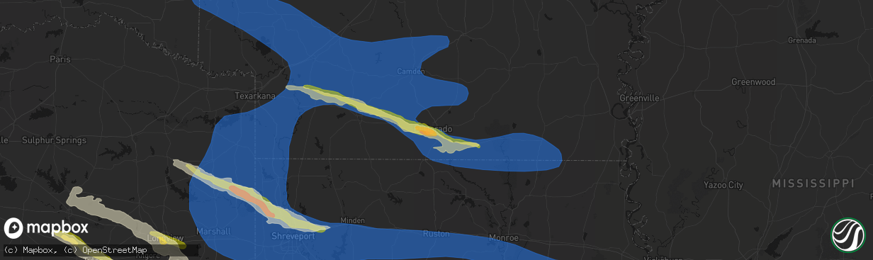
Hail Map in El Dorado, AR on March 15, 2026
The weather event in El Dorado, AR on March 15, 2026 includes Hail, Wind, and Tornado maps. 16 states and 1,702 cities were impacted and suffered possible damage. The total estimated number of properties impacted is 5,789.
Hail
Wind
Tornado
5,789
Estimated number of impacted properties by a 1.00" hail or larger260
Estimated number of impacted properties by a 1.75" hail or larger0
Estimated number of impacted properties by a 2.50" hail or largerStorm reports in El Dorado, AR
El Dorado, AR
| Date | Description |
|---|---|
| 03/15/20266:38 PM CDT | Report from mping: quarter |
| 03/15/20266:37 PM CDT | A tree was downed on champagnolle road just northeast of el dorado. |
| 03/15/20266:35 PM CDT | Ping pong ball to golfball size hail fell in the parkers chapel community. |
| 03/15/20266:32 PM CDT | Half dollar size hail fell on shuler road just southwest of el dorado. |
All States Impacted by Hail Map on March 15, 2026
All Cities Impacted by Hail Map on March 15, 2026
- Woodburn, IA
- Osceola, IA
- Alexander, IL
- Ashland, IL
- New Berlin, IL
- Pleasant Plains, IL
- Beardstown, IL
- Hettick, IL
- Palmyra, IL
- Bath, IL
- Kilbourne, IL
- Havana, IL
- Chandlerville, IL
- Easton, IL
- Lewistown, IL
- Browning, IL
- Springfield, IL
- Forest City, IL
- Manito, IL
- Mason City, IL
- Riverside, IA
- Kalona, IA
- Iowa City, IA
- Hills, IA
- Lincoln, AR
- Fayetteville, AR
- Summers, AR
- Prairie Grove, AR
- Farmington, AR
- Springdale, AR
- Okeechobee, FL
- Palm Bay, FL
- Lorida, FL
- Kimberling City, MO
- Reeds Spring, MO
- Fellsmere, FL
- Punta Gorda, FL
- Fort Meade, FL
- Lake Wales, FL
- Frostproof, FL
- Malabar, FL
- Dade City, FL
- Grant, FL
- Wesley Chapel, FL
- San Antonio, FL
- Land O'Lakes, FL
- Melbourne, FL
- Washington, IA
- West Branch, IA
- Spring Hill, FL
- Brooksville, FL
- Bartow, FL
- Wauchula, FL
- Broken Bow, OK
- Davenport, FL
- Kissimmee, FL
- Sebastian, FL
- Harrison, AR
- Bowling Green, FL
- Webster, FL
- Ona, FL
- Parrish, FL
- Eagletown, OK
- Haines City, FL
- Polk City, FL
- Idabel, OK
- Garvin, OK
- Mountain Grove, MO
- Cabool, MO
- Yellville, AR
- Flippin, AR
- Summit, AR
- Vanzant, MO
- Drury, MO
- Lake Alfred, FL
- Floral City, FL
- Everton, AR
- Gillham, AR
- De Queen, AR
- Grand Saline, TX
- Solo, MO
- Elk Creek, MO
- Houston, MO
- Yukon, MO
- Eunice, MO
- Raymondville, MO
- Hartshorn, MO
- De Kalb, TX
- Mountain Home, AR
- Gassville, AR
- Midway, AR
- Cotter, AR
- Cuba, MO
- Leasburg, MO
- Van, TX
- Canton, TX
- Willow Springs, MO
- Mena, AR
- Winthrop, AR
- Saint Cloud, FL
- Alba, TX
- Saint James, MO
- Quitman, TX
- Mineola, TX
- Salem, MO
- Plainview, AR
- Jadwin, MO
- Perryville, AR
- Summersville, MO
- Tyler, TX
- Lindale, TX
- Caddo Gap, AR
- Langley, AR
- Elizabeth, AR
- Clarkridge, AR
- Gepp, AR
- Gamaliel, AR
- Henderson, AR
- Mims, FL
- Pittsburg, TX
- Umpire, AR
- Lockesburg, AR
- Dierks, AR
- Norman, AR
- Glenwood, AR
- Hawkins, TX
- Windermere, FL
- Apopka, FL
- Longwood, FL
- Lake Mary, FL
- Inverness, FL
- Big Sandy, TX
- Bakersfield, MO
- Caulfield, MO
- Nashville, AR
- Sanford, FL
- Orlando, FL
- New Smyrna Beach, FL
- Port Orange, FL
- Oak Hill, FL
- Viola, AR
- Salem, AR
- Daingerfield, TX
- Mount Pleasant, TX
- Virginia, IL
- Montverde, FL
- Gotha, FL
- Chandler, TX
- Brownsboro, TX
- Moody, MO
- Clermont, FL
- Kampsville, IL
- Hamburg, IL
- Eldred, IL
- Fieldon, IL
- Carrollton, IL
- Rockbridge, IL
- White Hall, IL
- Paron, AR
- Houston, AR
- Roland, AR
- Bigelow, AR
- Mayflower, AR
- Omaha, TX
- Bullard, TX
- Flint, TX
- Murfreesboro, AR
- Bunker, MO
- Bonnerdale, AR
- Gilmer, TX
- Amity, AR
- Saratoga, AR
- Texarkana, AR
- Texarkana, TX
- Ashdown, AR
- Lithia, FL
- Hughes Springs, TX
- Arp, TX
- Troup, TX
- Conway, AR
- Maumelle, AR
- North Little Rock, AR
- Jacksonville, TX
- Fulton, AR
- Avinger, TX
- Lone Star, TX
- Gladewater, TX
- Brandon, FL
- Washington, AR
- Saint Louis, MO
- Madison, IL
- East Saint Louis, IL
- Granite City, IL
- Venice, IL
- Linden, TX
- Jefferson, TX
- Higden, AR
- Edgemont, AR
- Prim, AR
- Palestine, TX
- Longview, TX
- Hope, AR
- Lewisville, AR
- Kilgore, TX
- White Oak, TX
- Elkhart, TX
- Florissant, MO
- Overton, TX
- Alton, MO
- Delight, AR
- Okolona, AR
- Garland City, AR
- Sherwood, AR
- Jacksonville, AR
- Vilonia, AR
- Cabot, AR
- Austin, AR
- El Paso, AR
- Hallsville, TX
- Malvern, AR
- Silver Springs, FL
- Loami, IL
- Chatham, IL
- Drasco, AR
- Stamps, AR
- Emmet, AR
- Grapeland, TX
- Centerville, TX
- Henderson, TX
- Selman City, TX
- East Alton, IL
- Wood River, IL
- Rusk, TX
- Reklaw, TX
- Fort McCoy, FL
- Cottage Hills, IL
- Roxana, IL
- Hartford, IL
- Bivins, TX
- Jefferson, AR
- Redfield, AR
- Anthony, FL
- Gurdon, AR
- Laneville, TX
- Cushing, TX
- Glen Carbon, IL
- Maryville, IL
- Collinsville, IL
- Troy, IL
- Moro, IL
- Bethalto, IL
- Vivian, LA
- Oil City, LA
- Hoxie, AR
- Alicia, AR
- Crockett, TX
- Buckner, AR
- Waldo, AR
- Sparkman, AR
- Warren, AR
- New Edinburg, AR
- Banks, AR
- Tatum, TX
- Fults, IL
- Arkadelphia, AR
- Crescent City, FL
- Sherrill, AR
- Altheimer, AR
- Tucker, AR
- Alexander, AR
- Ward, AR
- Sheridan, AR
- Traskwood, AR
- Benton, AR
- Karnack, TX
- Bono, AR
- Powhatan, AR
- Walnut Ridge, AR
- Strawberry, AR
- Lynn, AR
- Delaplaine, AR
- O'Kean, AR
- Beech Grove, AR
- Smithville, AR
- Pocahontas, AR
- Mooringsport, LA
- Lonoke, AR
- Lovelady, TX
- Somerville, TX
- Rison, AR
- Wilmar, AR
- Magnolia, AR
- McNeil, AR
- White Hall, AR
- Nacogdoches, TX
- Hensley, AR
- Humnoke, AR
- Wabbaseka, AR
- England, AR
- Douglass, TX
- West Alton, MO
- Beckville, TX
- Carthage, TX
- Bauxite, AR
- Shreveport, LA
- Belcher, LA
- Rosston, AR
- Camden, AR
- Benton, LA
- Monticello, AR
- Stephens, AR
- Garrison, TX
- Little Rock, AR
- Carlisle, AR
- Des Arc, AR
- Hazen, AR
- Hickory Plains, AR
- Brenham, TX
- Griffithville, AR
- Kennard, TX
- Mount Holly, AR
- El Dorado, AR
- Paragould, AR
- Lafe, AR
- Knobel, AR
- Marmaduke, AR
- Harrisburg, AR
- Cash, AR
- Swifton, AR
- Tuckerman, AR
- Weiner, AR
- Newport, AR
- Bay, AR
- Jonesboro, AR
- Trumann, AR
- State University, AR
- Brookland, AR
- Lake City, AR
- Bossier City, LA
- Haughton, LA
- Irving, IL
- Fillmore, IL
- Witt, IL
- Nokomis, IL
- Bingham, IL
- Ramsey, IL
- Rosamond, IL
- Ohlman, IL
- Pana, IL
- Oconee, IL
- Assumption, IL
- Shelbyville, IL
- Herrick, IL
- Tower Hill, IL
- Lakewood, IL
- Chireno, TX
- Stuttgart, AR
- Bedias, TX
- Huntsville, TX
- Trinity, TX
- Apple Springs, TX
- Groveton, TX
- Augusta, AR
- Hamburg, AR
- Blanchard, LA
- Biscoe, AR
- Beebe, AR
- Cotton Plant, AR
- Searcy, AR
- McCrory, AR
- Brinkley, AR
- Wheatley, AR
- Hunter, AR
- Palestine, AR
- Clarendon, AR
- Addieville, IL
- Marissa, IL
- Princeton, LA
- Okawville, IL
- Bartelso, IL
- Oakdale, IL
- New Baden, IL
- Nashville, IL
- Carlyle, IL
- Centralia, IL
- Hoyleton, IL
- Richview, IL
- Hoffman, IL
- Rector, AR
- Greenway, AR
- Piggott, AR
- Kennett, MO
- Saint Francis, AR
- Campbell, MO
- Malden, MO
- Gibson, MO
- Holcomb, MO
- Clarkton, MO
- Gideon, MO
- Black Oak, AR
- Monette, AR
- Leachville, AR
- Manila, AR
- Caraway, AR
- Arbyrd, MO
- Cardwell, MO
- Osceola, AR
- Etowah, AR
- Hornersville, MO
- Dell, AR
- Blytheville, AR
- Pine Bluff, AR
- Tillar, AR
- Oakhurst, TX
- Onalaska, TX
- Humphrey, AR
- Hermitage, AR
- Montrose, AR
- Corrigan, TX
- San Augustine, TX
- Lilbourn, MO
- Wardell, MO
- Portageville, MO
- Parma, MO
- Catron, MO
- Steele, MO
- Luxora, AR
- Dermott, AR
- Lake Village, AR
- Marston, MO
- Hughes, AR
- Proctor, AR
- Fountain Hill, AR
- Etoile, TX
- Star City, AR
- Minden, LA
- Pointblank, TX
- Livingston, TX
- De Witt, AR
- Saint Charles, AR
- Yorktown, AR
- Grady, AR
- Junction City, AR
- Willis, TX
- New Waverly, TX
- Logansport, LA
- Pickens, AR
- Winchester, AR
- Watson, AR
- McGehee, AR
- Rohwer, AR
- Strong, AR
- Wynne, AR
- Colt, AR
- Forrest City, AR
- Widener, AR
- Goodwin, AR
- Lillie, LA
- Summerfield, LA
- Bronson, TX
- Broaddus, TX
- Conroe, TX
- Chester, TX
- Athens, LA
- Dubberly, LA
- Gibsland, LA
- Louann, AR
- Benoit, MS
- Almyra, AR
- Marvell, AR
- Elaine, AR
- Holly Grove, AR
- Sibley, LA
- Doyline, LA
- Heflin, LA
- Mansfield, LA
- Grand Cane, LA
- Hernando, MS
- Tunica, MS
- Robinsonville, MS
- Lake Cormorant, MS
- Carbondale, IL
- Cambria, IL
- Marion, IL
- Carterville, IL
- De Soto, IL
- Herrin, IL
- Energy, IL
- Pittsburg, IL
- Johnston City, IL
- Windsor, IL
- Findlay, IL
- Bethany, IL
- Sullivan, IL
- Arthur, IL
- Arcola, IL
- Mattoon, IL
- Gays, IL
- Tuscola, IL
- Humboldt, IL
- Villa Grove, IL
- Camargo, IL
- Newman, IL
- Hume, IL
- Broadlands, IL
- Sidney, IL
- Murdock, IL
- Longview, IL
- Philo, IL
- Allerton, IL
- Homer, IL
- Sidell, IL
- Converse, LA
- Portland, AR
- Arcadia, LA
- Bienville, LA
- Woodville, TX
- Shepherd, TX
- Coldspring, TX
- Goodrich, TX
- Colmesneil, TX
- Lexa, AR
- Helena, AR
- Pineland, TX
- Shelbyville, TX
- Huttig, AR
- Greenville, MS
- Brookeland, TX
- Cleveland, TX
- Splendora, TX
- Pelican, LA
- Beulah, MS
- Mount Enterprise, TX
- Ruston, LA
- Simsboro, LA
- West Helena, AR
- Spearsville, LA
- Hemphill, TX
- Pleasant Hill, LA
- New Caney, TX
- Saratoga, TX
- Kountze, TX
- Wiergate, TX
- Indianola, IL
- Oakwood, IL
- Fairmount, IL
- Tilton, IL
- Fithian, IL
- Westville, IL
- Danville, IL
- Catlin, IL
- East Prairie, MO
- Clinton, KY
- Hickman, KY
- Arlington, KY
- Columbus, KY
- Bardwell, KY
- Marshall, TX
- Bloomburg, TX
- Doddridge, AR
- Fouke, AR
- Queen City, TX
- Maud, TX
- Douglassville, TX
- Harleton, TX
- Atlanta, TX
- Ida, LA
- Bradley, AR
- Rodessa, LA
- Taylor, AR
- Emerson, AR
- Hosston, LA
- Plain Dealing, LA
- Gilliam, LA
- Springhill, LA
- Louisville, IL
- Xenia, IL
- Sarepta, LA
- Shongaloo, LA
- Waskom, TX
- Cotton Valley, LA
- Greenwood, LA
- Bethany, LA
- De Berry, TX
- Prescott, AR
- Willisville, AR
- Chidester, AR
- Bluff City, AR
- Smackover, AR
- Hampton, AR
- Haynesville, LA
- Sarah, MS
- Belmont, LA
- Zwolle, LA
- Marthaville, LA
- Dundee, MS
- Rosedale, MS
- Ripley, MS
- Wilmot, AR
- Robeline, LA
- Coushatta, LA
- Crossett, AR
- Bastrop, LA
- Sledge, MS
- Bearden, AR
- Thornton, AR
- Calion, AR
- Homer, LA
- Keithville, LA
- Lisbon, LA
- Barksdale Afb, LA
- Bernice, LA
- Farmerville, LA
- Marion, LA
- Dubach, LA
- Elm Grove, LA
- Grambling, LA
- Stonewall, LA
- Ringgold, LA
- Jamestown, LA
- Quitman, LA
- Choudrant, LA
- Downsville, LA
- Calhoun, LA
- Monroe, LA
- Eros, LA
- West Monroe, LA
- Mangham, LA
- Oak Ridge, LA
- Rayville, LA
- Cooter, MO
- Caruthersville, MO
- Finley, TN
- Jones, LA
- Ramer, TN
- Selmer, TN
- Stantonville, TN
- Guys, TN
- Coldwater, MS
- Pocahontas, TN
- Corinth, MS
- Walnut, MS
- Leland, MS
- Spurger, TX
- Natchitoches, LA
- Many, LA
- Tiplersville, MS
- Huffman, TX
- Blevins, AR
- McCaskill, AR
- Ozan, AR
- Mineral Springs, AR
- Columbus, AR
- Horatio, AR
- Wilton, AR
- Ogden, AR
- Alleene, AR
- Eudora, AR
- Kirbyville, TX
- Burkeville, TX
- Michie, TN
- Bonita, LA
- Rienzi, MS
- Evans, LA
- Bismarck, IL
- Covington, IN
- Attica, IN
- West Lebanon, IN
- State Line, IN
- Williamsport, IN
- Shiloh, TN
- Counce, TN
- Savannah, TN
- Pontotoc, MS
- Ecru, MS
- Belden, MS
- Blue Springs, MS
- Leesville, LA
- Newton, TX
- Provencal, LA
- Fulton, KY
- South Fulton, TN
- Water Valley, KY
- Wingo, KY
- Sedalia, KY
- Mayfield, KY
- Farmington, KY
- Murray, KY
- Hazel, KY
- Almo, KY
- Adamsville, TN
- Lutts, TN
- Iuka, MS
- Burnsville, MS
- Waterloo, AL
- Crump, TN
- Morris Chapel, TN
- Waynesboro, TN
- Olivehill, TN
- Collinwood, TN
- Clifton, TN
- Dexter, KY
- Cadiz, KY
- New Concord, KY
- Big Rock, TN
- Dover, TN
- Bumpus Mills, TN
- Kirksey, KY
- Baskin, LA
- Tupelo, MS
- Saltillo, MS
- Guntown, MS
- Oak Grove, LA
- Hollandale, MS
- Glen, MS
- Deridder, LA
- Cypress Inn, TN
- Puryear, TN
- Palmersville, TN
- Cottage Grove, TN
- Paris, TN
- Buchanan, TN
- Springville, TN
- Big Sandy, TN
- Stewart, TN
- Cumberland City, TN
- Erin, TN
- Tennessee Ridge, TN
- Indian Mound, TN
- Martin, TN
- Dukedom, TN
- Dresden, TN
- Waverly, TN
- Gracey, KY
- La Fayette, KY
- Hopkinsville, KY
- Herndon, KY
- Fort Campbell, KY
- Benton, KY
- Hardin, KY
- Cerulean, KY
- Princeton, KY
- Crofton, KY
- Eddyville, KY
- Woodlawn, TN
- White Plains, KY
- Oak Grove, KY
- Pembroke, KY
- Palmyra, TN
- Linden, TN
- Anguilla, MS
- Dry Prong, LA
- Baldwyn, MS
- Booneville, MS
- Pitkin, LA
- Lyford, TX
- Winnsboro, LA
- Grayville, IL
- Shawneetown, IL
- Wadesville, IN
- Uniontown, KY
- Poseyville, IN
- New Harmony, IN
- Morganfield, KY
- Crossville, IL
- Henderson, KY
- Junction, IL
- Omaha, IL
- Ridgway, IL
- Norris City, IL
- Evansville, IN
- Waverly, KY
- Griffin, IN
- New Haven, IL
- Equality, IL
- Mount Vernon, IN
- Carmi, IL
- Corydon, KY
- Mount Carmel, IL
- Owensville, IN
- Princeton, IN
- Fort Branch, IN
- Haubstadt, IN
- Cynthiana, IN
- Richland, IN
- Elberfeld, IN
- Chandler, IN
- Spottsville, KY
- Rockport, IN
- Reed, KY
- Newburgh, IN
- Owensboro, KY
- Patoka, IN
- Boonville, IN
- Lynnville, IN
- Chrisney, IN
- Tennyson, IN
- Grandview, IN
- Francisco, IN
- Spurgeon, IN
- Velpen, IN
- Petersburg, IN
- Stendal, IN
- Gentryville, IN
- Oakland City, IN
- Hazleton, IN
- Winslow, IN
- Dale, IN
- Dubois, IN
- Holland, IN
- Santa Claus, IN
- Otwell, IN
- Lincoln City, IN
- Loogootee, IN
- Cannelburg, IN
- Ferdinand, IN
- Lamar, IN
- Washington, IN
- Jasper, IN
- Shoals, IN
- Huntingburg, IN
- Montgomery, IN
- Schnellville, IN
- Leopold, IN
- Cannelton, IN
- Taswell, IN
- English, IN
- Sulphur, IN
- Tell City, IN
- Evanston, IN
- Saint Meinrad, IN
- Troy, IN
- Birdseye, IN
- Celestine, IN
- French Lick, IN
- Saint Anthony, IN
- Branchville, IN
- Battletown, KY
- Grantsburg, IN
- Leavenworth, IN
- Bristow, IN
- Eckerty, IN
- Saint Croix, IN
- Monroe City, IN
- Parkersburg, IL
- Saint Francisville, IL
- Calhoun, IL
- Bridgeport, IL
- Bellmont, IL
- Sumner, IL
- Allendale, IL
- West Salem, IL
- Decker, IN
- Browns, IL
- Bone Gap, IL
- Albion, IL
- Claremont, IL
- Golden Gate, IL
- Burnt Prairie, IL
- Ellery, IL
- Wheatland, IN
- Flat Rock, IL
- Bruceville, IN
- Lawrenceville, IL
- Palestine, IL
- Oaktown, IN
- Vincennes, IN
- Hutsonville, IL
- Robinson, IL
- Dugger, IN
- Freelandville, IN
- Merom, IN
- Lyons, IN
- Coalmont, IN
- Sandborn, IN
- Linton, IN
- Farmersburg, IN
- Jasonville, IN
- Hymera, IN
- Elnora, IN
- Bicknell, IN
- Pimento, IN
- Fairbanks, IN
- Shelburn, IN
- Terre Haute, IN
- Plainville, IN
- Westphalia, IN
- Carlisle, IN
- Odon, IN
- Lewis, IN
- Edwardsport, IN
- West Union, IL
- Sullivan, IN
- Ragsdale, IN
- Owensburg, IN
- Clay City, IN
- Scotland, IN
- Freedom, IN
- Bloomfield, IN
- Williams, IN
- Newberry, IN
- Coal City, IN
- Switz City, IN
- Centerpoint, IN
- Bowling Green, IN
- Cory, IN
- Worthington, IN
- Paoli, IN
- West Baden Springs, IN
- Mitchell, IN
- Riley, IN
- Crane, IN
- Springville, IN
- Brazil, IN
- Carbon, IN
- Poland, IN
- Bedford, IN
- Staunton, IN
- Patricksburg, IN
- Knightsville, IN
- Marengo, IN
- Greencastle, IN
- Spencer, IN
- Harmony, IN
- Reelsville, IN
- Orleans, IN
- Solsberry, IN
- Bloomington, IN
- Hardinsburg, IN
- Cloverdale, IN
- Marietta, MS
- New Site, MS
- Tishomingo, MS
- Belzoni, MS
- Hurricane Mills, TN
- Lobelville, TN
- Pollock, LA
- Georgetown, LA
- Trout, LA
- Bentley, LA
- Delhi, LA
- Long Branch, TX
- Ellettsville, IN
- Lawrenceburg, TN
- San Perlita, TX
- Jena, LA
- Tallulah, LA
- Louise, MS
- Dennis, MS
- McEwen, TN
- Only, TN
- Dickson, TN
- Mayersville, MS
- Pioneer, LA
- Lake Providence, LA
- Sugartown, LA
- Dry Creek, LA
- Grant, LA
- Mittie, LA
- Jonesville, LA
- Cherokee, AL
- Parkdale, AR
- Summertown, TN
- Hohenwald, TN
- Charlotte, TN
- Nunnelly, TN
- Bon Aqua, TN
- Florence, AL
- Oakdale, LA
- Monterey, LA
- North Charleston, SC
- Kinder, LA
- Avoca, IN
- Martinsville, IN
- Gosport, IN
- Heltonville, IN
- Trafalgar, IN
- Nashville, IN
- Norman, IN
- Morgantown, IN
- Franklin, IN
- Bargersville, IN
- Unionville, IN
- Oolitic, IN
- Whiteland, IN
- Oberlin, LA
- Nesbit, MS
- Quincy, IN
- Clayton, IN
- Fillmore, IN
- Stinesville, IN
- Stilesville, IN
- Paragon, IN
- Monrovia, IN
- Coatesville, IN
- Mooresville, IN
- Greenwood, IN
- Danville, IN
- Avon, IN
- Brooklyn, IN
- Beech Grove, IN
- Carmel, IN
- Camby, IN
- Plainfield, IN
- Indianapolis, IN
- West Newton, IN
- Charleston, SC
- Needham, IN
- Nineveh, IN
- Fairland, IN
- Flat Rock, IN
- Columbus, IN
- Freetown, IN
- Boggstown, IN
- Edinburgh, IN
- Seymour, IN
- Taylorsville, IN
- Shelbyville, IN
- Tunnelton, IN
- Medora, IN
- Brownstown, IN
- Troy, TN
- Union City, TN
- Hornbeak, TN
- Rives, TN
- Obion, TN
- Ridgely, TN
- Dyersburg, TN
- Kenton, TN
- Newbern, TN
- Trimble, TN
- Halls, TN
- Lenox, TN
- Ripley, TN
- Friendship, TN
- Gates, TN
- Henning, TN
- Trenton, TN
- Dyer, TN
- Rutherford, TN
- Brownsville, TN
- Sharon, TN
- Covington, TN
- Stanton, TN
- Alamo, TN
- Mason, TN
- Bells, TN
- Gadsden, TN
- Greenfield, TN
- Bradford, TN
- Humboldt, TN
- Milan, TN
- Gleason, TN
- Atwood, TN
- McKenzie, TN
- Henry, TN
- Hartsville, IN
- Clifford, IN
- Hope, IN
- Westport, IN
- Mansfield, TN
- Eva, TN
- Burns, TN
- Vanleer, TN
- White Bluff, TN
- Browder, KY
- Beaver Dam, KY
- Elkton, KY
- Olmstead, KY
- Beechmont, KY
- Allensville, KY
- Greenville, KY
- Guthrie, KY
- Russellville, KY
- Southside, TN
- Sharon Grove, KY
- Lewisburg, KY
- Cumberland Furnace, TN
- Adams, TN
- Rochester, KY
- Chapmansboro, TN
- Drakesboro, KY
- Trenton, KY
- Cedar Hill, TN
- Beech Creek, KY
- Pleasant View, TN
- Morgantown, KY
- Cunningham, TN
- Adairville, KY
- Ashland City, TN
- Belton, KY
- Clarksville, TN
- Dunmor, KY
- Nashville, TN
- Gallatin, TN
- Cross Plains, TN
- Cottontown, TN
- Greenbrier, TN
- Hendersonville, TN
- Portland, TN
- Goodlettsville, TN
- Rockfield, KY
- Springfield, TN
- Kingston Springs, TN
- Auburn, KY
- Whites Creek, TN
- Woodburn, KY
- White House, TN
- Franklin, KY
- Pegram, TN
- Orlinda, TN
- Joelton, TN
- Bowling Green, KY
- McHenry, KY
- Hartford, KY
- Powderly, KY
- Central City, KY
- Rockport, KY
- Centertown, KY
- Cromwell, KY
- Bremen, KY
- Graham, KY
- Nortonville, KY
- Dawson Springs, KY
- Saint Charles, KY
- Madisonville, KY
- Horse Branch, KY
- Caneyville, KY
- Falls Of Rough, KY
- Fordsville, KY
- Jetson, KY
- Olaton, KY
- Dundee, KY
- Rosine, KY
- Brownsville, KY
- Roundhill, KY
- Millwood, KY
- Bee Spring, KY
- Leitchfield, KY
- Clarkson, KY
- Sweeden, KY
- Custer, KY
- Hudson, KY
- Eastview, KY
- Garfield, KY
- Westview, KY
- Big Clifty, KY
- Cecilia, KY
- McDaniels, KY
- Hardinsburg, KY
- Island, KY
- Sacramento, KY
- Mortons Gap, KY
- Vine Grove, KY
- Radcliff, KY
- Glendale, KY
- Elizabethtown, KY
- Rineyville, KY
- White Mills, KY
- Newellton, LA
- Iowa, LA
- Goose Creek, SC
- Ladson, SC
- Hanahan, SC
- Johns Island, SC
- Ravenel, SC
- Vidalia, LA
- Harrisonburg, LA
- Natchez, MS
- Summerville, SC
- Charleston Afb, SC
- Tuscumbia, AL
- Mount Pleasant, TN
- Ethridge, TN
- Ferriday, LA
- Moncks Corner, SC
- Killen, AL
- Sicily Island, LA
- Columbia, TN
- Sturkie, AR
- Bexar, AR
- Lexington, AL
- Loretto, TN
- Mamou, LA
- Saint Joseph, TN
- Hampshire, TN
- Eunice, LA
- Kennard, IN
- Greensburg, IN
- Arlington, IN
- Milroy, IN
- Shirley, IN
- Middletown, IN
- Mccordsville, IN
- Rushville, IN
- Saint Paul, IN
- Maxwell, IN
- Greenfield, IN
- New Palestine, IN
- Gwynneville, IN
- Fountaintown, IN
- Muncie, IN
- Lapel, IN
- Fishers, IN
- Charlottesville, IN
- Ingalls, IN
- Morristown, IN
- Pendleton, IN
- Fortville, IN
- Anderson, IN
- Noblesville, IN
- Homer, IN
- Markleville, IN
- Daleville, IN
- Wilkinson, IN
- Manilla, IN
- New Castle, IN
- Knightstown, IN
- Waldron, IN
- Carthage, IN
- Elwood, IN
- Frankton, IN
- Oldenburg, IN
- Laurel, IN
- Metamora, IN
- Mays, IN
- Spiceland, IN
- Connersville, IN
- Glenwood, IN
- Lewisville, IN
- Alexandria, IN
- Falmouth, IN
- Sunman, IN
- Brookville, IN
- Batesville, IN
- Osgood, IN
- Gaston, IN
- Jonesboro, IN
- Yorktown, IN
- Milton, IN
- Summitville, IN
- Straughn, IN
- Fowlerton, IN
- Cambridge City, IN
- Gas City, IN
- Fairmount, IN
- Springport, IN
- Mammoth Cave, KY
- Cub Run, KY
- Sonora, KY
- Horse Cave, KY
- Upton, KY
- Bonnieville, KY
- Munfordville, KY
- Shepherdsville, KY
- Hardyville, KY
- Boston, KY
- West Point, KY
- Hodgenville, KY
- Magnolia, KY
- Lebanon Junction, KY
- New Haven, KY
- Taylorsville, KY
- Clermont, KY
- Bardstown, KY
- Buffalo, KY
- Coxs Creek, KY
- Mount Washington, KY
- Saint Francis, KY
- Greensburg, KY
- Summersville, KY
- Lebanon, KY
- Springfield, KY
- New Hope, KY
- Campbellsville, KY
- Bloomfield, KY
- Canmer, KY
- Mount Sherman, KY
- Raywick, KY
- Loretto, KY
- Louisville, KY
- Fisherville, KY
- Fairfield, KY
- Simpsonville, KY
- Finchville, KY
- Chaplin, KY
- Lawrenceburg, KY
- Shelbyville, KY
- Harrodsburg, KY
- Perryville, KY
- Mount Eden, KY
- Gravel Switch, KY
- Saint Catharine, KY
- Willisburg, KY
- Bradfordsville, KY
- Mackville, KY
- Danville, KY
- Ville Platte, LA
- Opelousas, LA
- Roxie, MS
- Williamsport, TN
- Culleoka, TN
- Lewisburg, TN
- Spring Hill, TN
- Chapel Hill, TN
- College Grove, TN
- Eagleville, TN
- Church Point, LA
- Lebanon, TN
- Pulaski, TN
- Losantville, IN
- Mooreland, IN
- Upland, IN
- Hagerstown, IN
- Selma, IN
- Matthews, IN
- Westpoint, TN
- Iron City, TN
- Utica, KY
- Livermore, KY
- Whitesville, KY
- Cloverport, KY
- Reynolds Station, KY
- Stephensport, KY
- Harned, KY
- Irvington, KY
- Rhodelia, KY
- Ekron, KY
- Union Star, KY
- Guston, KY
- Payneville, KY
- Webster, KY
- Brandenburg, KY
- Mauckport, IN
- Laconia, IN
- Corydon, IN
- Fort Knox, KY
- Central, IN
- New Middletown, IN
- Brooks, KY
- Elizabeth, IN
- Muldraugh, KY
- Clarksville, IN
- Masonic Home, KY
- Fairdale, KY
- Lanesville, IN
- Greenville, IN
- Jeffersonville, IN
- New Albany, IN
- Floyds Knobs, IN
- Crandall, IN
- Georgetown, IN
- New Salisbury, IN
- Goshen, KY
- Prospect, KY
- Pewee Valley, KY
- Crestwood, KY
- Borden, IN
- Sellersburg, IN
- Glenview, KY
- Charlestown, IN
- Memphis, IN
- Westport, KY
- La Grange, KY
- Buckner, KY
- Nabb, IN
- Lexington, IN
- Marysville, IN
- Otisco, IN
- New Washington, IN
- Pendleton, KY
- Hanover, IN
- Milton, KY
- Smithfield, KY
- Bethlehem, IN
- Waddy, KY
- Bedford, KY
- Carrollton, KY
- Turners Station, KY
- Frankfort, KY
- Madison, IN
- Sulphur, KY
- Eminence, KY
- Campbellsburg, KY
- Salvisa, KY
- Vevay, IN
- Bagdad, KY
- Pleasureville, KY
- New Castle, KY
- Lockport, KY
- Stamping Ground, KY
- Lancaster, KY
- Nicholasville, KY
- Versailles, KY
- Ghent, KY
- Wilmore, KY
- Worthville, KY
- Owenton, KY
- Georgetown, KY
- Midway, KY
- Sanders, KY
- Perry Park, KY
- New Liberty, KY
- Lexington, KY
- Bethlehem, KY
- Burgin, KY
- Glencoe, KY
- Sadieville, KY
- Sparta, KY
- Jonesville, KY
- Warsaw, KY
- Corinth, KY
- Crittenden, KY
- Dry Ridge, KY
- Williamstown, KY
- Verona, KY
- Unionville, TN
- Christiana, TN
- Murfreesboro, TN
- Bell Buckle, TN
- Rockvale, TN
- Arrington, TN
- Smyrna, TN
- Lascassas, TN
- Milton, TN
- Watertown, TN
- Brush Creek, TN
- Liberty, TN
- Hickman, TN
- Auburntown, TN
- Alexandria, TN
- Woodbury, TN
- Readyville, TN
- Gordonsville, TN
- Riddleton, TN
- Carthage, TN
- Lancaster, TN
- Dowelltown, TN
- Buffalo Valley, TN
- Granville, TN
- Gainesboro, TN
- Whitleyville, TN
- Chestnut Mound, TN
- Elmwood, TN
- Pleasant Shade, TN
- Silver Point, TN
- Bloomington Springs, TN
- Smithville, TN
- Baxter, TN
- Port Barre, LA
- Goodspring, TN
- Cookeville, TN
- Rickman, TN
- Monterey, TN
- Hilham, TN
- Crawford, TN
- Livingston, TN
- Alpine, TN
- Clarkrange, TN
- Wilder, TN
- Grimsley, TN
- Allred, TN
- Allons, TN
- Monroe, TN
- Celina, TN
- Jamestown, TN
- Huntland, TN
- Prospect, TN
- Golden, MS
- Fulton, MS
- Fackler, AL
- Stevenson, AL
- Brighton, TN
- Atlanta, IN
- Atoka, TN
- Sparta, TN
- Beatrice, AL
- Fairfield Bay, AR
- Lacombe, LA
- Blue Mountain, MS
- Slidell, LA
- Marrero, LA
- Harvey, LA
- Forest Home, AL
- Saucier, MS
- Gretna, LA
- Belle Chasse, LA
- New Orleans, LA
- Braithwaite, LA
- Violet, LA
- Meraux, LA
- Saint Bernard, LA
- Vancleave, MS
- Perkinston, MS
- Valdosta, GA
- Moody Afb, GA
- Naylor, GA
- Lakeland, GA
- Wetumpka, AL
- Mobile, AL
- Semmes, AL
- Eight Mile, AL
- Wilmer, AL
- Hahira, GA
- Nashville, GA
- Adel, GA
- Evergreen, AL
- Saraland, AL
- Satsuma, AL
- Creola, AL
- Castleberry, AL
- Ray City, GA
- Red Level, AL
- Greenville, AL
- Georgiana, AL
- Hamilton, GA
- Shiloh, GA
- Woodland, GA
- Warm Springs, GA
- Manchester, GA
- Pine Mountain Valley, GA
- Woodbury, GA
- Molena, GA
- Thomaston, GA
- Bon Secour, AL
- Gulf Shores, AL
- Foley, AL
- Barnesville, GA
- Yatesville, GA
- The Rock, GA
- Meansville, GA
- Eufaula, AL
- Elberta, AL
- Greenville, SC
- Duncan, SC
- Greer, SC
- Macon, GA
- Abbeville, AL
- Harrison, GA
- Orland Park, IL
- Lockport, IL
- Tinley Park, IL
- Mokena, IL
- Oak Forest, IL
- New Lenox, IL
- Homer Glen, IL
- South Holland, IL
- Dolton, IL
- Riverdale, IL
- Blue Island, IL
- Calumet City, IL
- Edinburg, IL
- Pawnee, IL
- Homerville, GA
- Taylorville, IL
- Rochester, IL
- Palmer, IL
- Stonington, IL
- Morrisonville, IL
- Owaneco, IL
- White Pigeon, MI
- Howe, IN
- Sturgis, MI
- Shipshewana, IN
- Ballwin, MO
- Chesterfield, MO
- Lovejoy, IL
- Fenton, MO
- Valley Park, MO
- Eminence, MO
- Coffeen, IL
- Litchfield, IL
- Mount Olive, IL
- Hillsboro, IL
- Walshville, IL
- Staunton, IL
- Bunker Hill, IL
- Sorento, IL
- Alhambra, IL
- Butler, IL
- Livingston, IL
- Dorsey, IL
- Edwardsville, IL
- New Douglas, IL
- Hamel, IL
- Worden, IL
- Panama, IL
- Donnellson, IL
- Taylor Springs, IL
- Lenzburg, IL
- Saint Libory, IL
- Prairie Du Rocher, IL
- Coulterville, IL
- New Athens, IL
- Red Bud, IL
- Baldwin, IL
- Mascoutah, IL
- Sparta, IL
- Evansville, IL
- Lodi, MO
- Clubb, MO
- Greenville, MO
- Patterson, MO
- Silva, MO
- Marquand, MO
- Marble Hill, MO
- Oak Ridge, MO
- Jackson, MO
- Patton, MO
- Sedgewickville, MO
- Daisy, MO
- Millersville, MO
- Friedheim, MO
- Mechanicsburg, IL
- Divernon, IL
- Dawson, IL
- Waverly, IL
- Glenarm, IL
- Virden, IL
- Riverton, IL
- Auburn, IL
- Buffalo, IL
- Lincoln, IL
- Campti, LA
- Goldonna, LA
- Noble, LA
- Arcadia, IN
- Sheridan, IN
- Westfield, IN
- Tipton, IN
- Cicero, IN
- Atlanta, LA
- Natchez, LA
- Montgomery, LA
- Colfax, LA
- Winnfield, LA
- Clayton, LA
- Myrtle, MS
- Hickory Flat, MS
- Falkner, MS
- Walls, MS
- Olive Branch, MS
- West Memphis, AR
- Marion, AR
- Byhalia, MS
- Memphis, TN
- Southaven, MS
- Horn Lake, MS
- Senatobia, MS
- Holcomb, MS
- Grenada, MS
- Coffeeville, MS
- Bruce, MS
- Big Creek, MS
- Banner, MS
- Water Valley, MS
- Randolph, MS
- Houlka, MS
- Vardaman, MS
- Pittsboro, MS
- Leoma, TN
- Elkmont, AL
- Minor Hill, TN
- Anderson, AL
- Lester, AL
- Rogersville, AL
- Five Points, TN
- Athens, AL
- Sheffield, AL
- Muscle Shoals, AL
- Leighton, AL
- Town Creek, AL
- Whitley City, KY
- Parkers Lake, KY
- Russell Springs, KY
- Corbin, KY
- Somerset, KY
- Stearns, KY
- Ferguson, KY
- Bronston, KY
- Monticello, KY
- Burnside, KY
- Nancy, KY
- London, KY
- Woodbine, KY
- Gray, KY
- Keavy, KY
- Lily, KY
- Barbourville, KY
- Manchester, KY
- Calhoun City, MS
- Harpersville, AL
- Alpine, AL
- Sylacauga, AL
- Talladega, AL
- Vincent, AL
- Childersburg, AL
- Munford, AL
- Lineville, AL
- Oxford, AL
- Anniston, AL
- Lovington, IL


