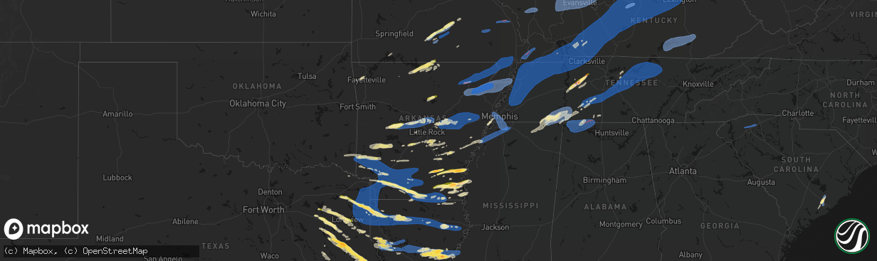
Hail Map in Arkansas on March 15, 2026
The weather event in Arkansas on March 15, 2026 includes Hail, Wind, and Tornado maps. 16 states and 1,702 cities were impacted and suffered possible damage. The total estimated number of properties impacted is 22,658.
Hail
Wind
Tornado
22,658
Estimated number of impacted properties by a 1.00" hail or larger727
Estimated number of impacted properties by a 1.75" hail or larger0
Estimated number of impacted properties by a 2.50" hail or largerStorm reports in Arkansas
Arkansas
| Date | Description |
|---|---|
| 03/15/20266:50 PM CDT | A local report indicates 1.75 inch wind near 7 NNE Montrose |
| 03/15/20266:50 PM CDT | A local report indicates 1.25 inch wind near Jerome |
| 03/15/20266:48 PM CDT | A local report indicates 1.00 inch wind near Fountain Hill |
| 03/15/20266:47 PM CDT | Roof damage and powerlines downed at lake and beauchamp street. |
| 03/15/20266:38 PM CDT | Report from mping: quarter |
| 03/15/20266:37 PM CDT | A tree was downed on champagnolle road just northeast of el dorado. |
| 03/15/20266:35 PM CDT | Ping pong ball to golfball size hail fell in the parkers chapel community. |
| 03/15/20266:32 PM CDT | Half dollar size hail fell on shuler road just southwest of el dorado. |
| 03/15/20266:24 PM CDT | Damage to a home... Barn... And several downed trees off of cr 420. |
| 03/15/20266:22 PM CDT | 9 power poles snapped on 135 s... Between 412 e and george rays. |
| 03/15/20266:19 PM CDT | Roof shingles torn off at edgemont circle in jonesboro. |
| 03/15/20266:19 PM CDT | A carport was destroyed on reno street in jonesboro. |
| 03/15/20266:18 PM CDT | A local report indicates 75 MPH wind near 2 ENE Jonesboro |
| 03/15/20266:15 PM CDT | Measured wind gust of 68 mph at the lawson and culberhouse intersection... South side of jonesboro. |
| 03/15/20266:15 PM CDT | Trees down. |
| 03/15/20266:15 PM CDT | A local report indicates 1.25 inch wind near 3 NW Monticello Municip |
| 03/15/20266:14 PM CDT | Trees downed blocking cr 625... 1/2 mile west of cr 627. |
| 03/15/20266:14 PM CDT | Several trees downed across lafe. |
| 03/15/20266:10 PM CDT | Several trees down across stuttgart. |
| 03/15/20266:10 PM CDT | Pws measurement near the corning airport. |
| 03/15/20266:01 PM CDT | A brief rope tornado occurred east of humphrey. This tornado was documented via drone from near l r shannon lane to just east of goldman sunshine rd. The tornado occurr |
| 03/15/20265:50 PM CDT | Union pacific railroad weather station. |
| 03/15/20265:50 PM CDT | A local report indicates 1.75 inch wind near Rye |
| 03/15/20265:46 PM CDT | Several power poles down in this area. |
| 03/15/20265:45 PM CDT | Several mobile homes with roofs torn off. Several power poles down in this area. |
| 03/15/20265:45 PM CDT | This is a delayed report. Nws storm survey crew found damage consistent with an ef-1 tornado with peak winds estimated at 105 mph. Damage surveyed discovered primarily |
| 03/15/20265:35 PM CDT | A few trees were knocked down in this area. |
| 03/15/20265:31 PM CDT | Asos station klit little rock adams field. |
| 03/15/20265:28 PM CDT | A local report indicates 1.00 inch wind near 1 SE Gravel Junction |
| 03/15/20265:27 PM CDT | Multiple trees down across highway 371 in laneburg. Time estimated by radar. |
| 03/15/20265:25 PM CDT | A local report indicates 1.00 inch wind near 3 SE Traskwood |
| 03/15/20265:25 PM CDT | Three power poles were broken near rose bud leading to over 3...000 without power. |
| 03/15/20265:25 PM CDT | Trees and powerlines down in this area along highway 229. |
| 03/15/20265:23 PM CDT | A tree was downed across highway 71 near mm 1 in southern miller county. Other sporadic downed trees were reported across the county as well. |
| 03/15/20265:15 PM CDT | Several trees blown down in malvern. |
| 03/15/20265:15 PM CDT | Two barns had their roofs removed by strong winds in this area. |
| 03/15/20265:00 PM CDT | A home had two trees fall on it. |
| 03/15/20265:00 PM CDT | Trees and powerlines down throughout the city of hope. Time estimated by radar. |
| 03/15/20265:00 PM CDT | A local report indicates 1.00 inch wind near Greers Ferry |
| 03/15/20264:55 PM CDT | A tin roof was blown off of a shed and multiple trees down in this area. |
| 03/15/20264:55 PM CDT | A tree was knocked down onto powerlines along highway 365. |
| 03/15/20264:54 PM CDT | A local report indicates 1.00 inch wind near 3 W Gold Creek |
| 03/15/20264:45 PM CDT | Trees and powerlines down in the vicinity of the town of mccaskill. Time estimated by radar. |
| 03/15/20264:35 PM CDT | A few trees uprooted in this area. |
| 03/15/20264:21 PM CDT | Report from mping: quarter |
| 03/15/20264:19 PM CDT | Trees were downed in nashville. |
| 03/15/20264:19 PM CDT | Report from mping: quarter |
| 03/15/20264:15 PM CDT | A local report indicates 1.00 inch wind near Hopper |
| 03/15/20264:10 PM CDT | Trees down in the center point community. |
| 03/15/20264:03 PM CDT | This a delayed report. Pictures show small metal farm building collapsed. |
| 03/15/20264:00 PM CDT | Heavy accumulation of hail noted in this area... Easily covering roadways and much of the ground. One depth measurement of the accumulated hail was between 2-3 inches d |
| 03/15/20263:59 PM CDT | Trees down in dierks. |
| 03/15/20263:58 PM CDT | Trees were downed in the central community between horatio and ben lomond. |
| 03/15/20263:50 PM CDT | A local report indicates 1.00 inch wind near Midway |
| 03/15/20263:47 PM CDT | Trees down on power lines just north of de queen. |
| 03/14/20267:37 PM CDT | Tree down blocking a part of hwy 65. |
| 03/14/20267:25 PM CDT | Report of scattered power outages across the city of west memphis with roof damage to southland casino. |
| 03/14/20267:22 PM CDT | A tree was blown down across a road in the felsenthal community. |
| 03/14/20267:17 PM CDT | Corrects previous non-tstm wnd gst report from pendleton. Mesonet station ard07 hwy. 165 pendleton. |
| 03/14/20267:10 PM CDT | Corrects previous non-tstm wnd gst report from pendleton. Mesonet station ard07 hwy. 165 pendleton. |
| 03/14/20267:00 PM CDT | A local report indicates 2.00 inch wind near Rohwer |
All States Impacted by Hail Map on March 15, 2026
Cities Impacted by Hail Map on March 15, 2026
- Woodburn, IA
- Osceola, IA
- Alexander, IL
- Ashland, IL
- New Berlin, IL
- Pleasant Plains, IL
- Beardstown, IL
- Hettick, IL
- Palmyra, IL
- Bath, IL
- Kilbourne, IL
- Havana, IL
- Chandlerville, IL
- Easton, IL
- Lewistown, IL
- Browning, IL
- Springfield, IL
- Forest City, IL
- Manito, IL
- Mason City, IL
- Riverside, IA
- Kalona, IA
- Iowa City, IA
- Hills, IA
- Lincoln, AR
- Fayetteville, AR
- Summers, AR
- Prairie Grove, AR
- Farmington, AR
- Springdale, AR
- Okeechobee, FL
- Palm Bay, FL
- Lorida, FL
- Kimberling City, MO
- Reeds Spring, MO
- Fellsmere, FL
- Punta Gorda, FL
- Fort Meade, FL
- Lake Wales, FL
- Frostproof, FL
- Malabar, FL
- Dade City, FL
- Grant, FL
- Wesley Chapel, FL
- San Antonio, FL
- Land O'Lakes, FL
- Melbourne, FL
- Washington, IA
- West Branch, IA
- Spring Hill, FL
- Brooksville, FL
- Bartow, FL
- Wauchula, FL
- Broken Bow, OK
- Davenport, FL
- Kissimmee, FL
- Sebastian, FL
- Harrison, AR
- Bowling Green, FL
- Webster, FL
- Ona, FL
- Parrish, FL
- Eagletown, OK
- Haines City, FL
- Polk City, FL
- Idabel, OK
- Garvin, OK
- Mountain Grove, MO
- Cabool, MO
- Yellville, AR
- Flippin, AR
- Summit, AR
- Vanzant, MO
- Drury, MO
- Lake Alfred, FL
- Floral City, FL
- Everton, AR
- Gillham, AR
- De Queen, AR
- Grand Saline, TX
- Solo, MO
- Elk Creek, MO
- Houston, MO
- Yukon, MO
- Eunice, MO
- Raymondville, MO
- Hartshorn, MO
- De Kalb, TX
- Mountain Home, AR
- Gassville, AR
- Midway, AR
- Cotter, AR
- Cuba, MO
- Leasburg, MO
- Van, TX
- Canton, TX
- Willow Springs, MO
- Mena, AR
- Winthrop, AR
- Saint Cloud, FL
- Alba, TX
- Saint James, MO
- Quitman, TX
- Mineola, TX
- Salem, MO
- Plainview, AR
- Jadwin, MO
- Perryville, AR
- Summersville, MO
- Tyler, TX
- Lindale, TX
- Caddo Gap, AR
- Langley, AR
- Elizabeth, AR
- Clarkridge, AR
- Gepp, AR
- Gamaliel, AR
- Henderson, AR
- Mims, FL
- Pittsburg, TX
- Umpire, AR
- Lockesburg, AR
- Dierks, AR
- Norman, AR
- Glenwood, AR
- Hawkins, TX
- Windermere, FL
- Apopka, FL
- Longwood, FL
- Lake Mary, FL
- Inverness, FL
- Big Sandy, TX
- Bakersfield, MO
- Caulfield, MO
- Nashville, AR
- Sanford, FL
- Orlando, FL
- New Smyrna Beach, FL
- Port Orange, FL
- Oak Hill, FL
- Viola, AR
- Salem, AR
- Daingerfield, TX
- Mount Pleasant, TX
- Virginia, IL
- Montverde, FL
- Gotha, FL
- Chandler, TX
- Brownsboro, TX
- Moody, MO
- Clermont, FL
- Kampsville, IL
- Hamburg, IL
- Eldred, IL
- Fieldon, IL
- Carrollton, IL
- Rockbridge, IL
- White Hall, IL
- Paron, AR
- Houston, AR
- Roland, AR
- Bigelow, AR
- Mayflower, AR
- Omaha, TX
- Bullard, TX
- Flint, TX
- Murfreesboro, AR
- Bunker, MO
- Bonnerdale, AR
- Gilmer, TX
- Amity, AR
- Saratoga, AR
- Texarkana, AR
- Texarkana, TX
- Ashdown, AR
- Lithia, FL
- Hughes Springs, TX
- Arp, TX
- Troup, TX
- Conway, AR
- Maumelle, AR
- North Little Rock, AR
- Jacksonville, TX
- Fulton, AR
- Avinger, TX
- Lone Star, TX
- Gladewater, TX
- Brandon, FL
- Washington, AR
- Saint Louis, MO
- Madison, IL
- East Saint Louis, IL
- Granite City, IL
- Venice, IL
- Linden, TX
- Jefferson, TX
- Higden, AR
- Edgemont, AR
- Prim, AR
- Palestine, TX
- Longview, TX
- Hope, AR
- Lewisville, AR
- Kilgore, TX
- White Oak, TX
- Elkhart, TX
- Florissant, MO
- Overton, TX
- Alton, MO
- Delight, AR
- Okolona, AR
- Garland City, AR
- Sherwood, AR
- Jacksonville, AR
- Vilonia, AR
- Cabot, AR
- Austin, AR
- El Paso, AR
- Hallsville, TX
- Malvern, AR
- Silver Springs, FL
- Loami, IL
- Chatham, IL
- Drasco, AR
- Stamps, AR
- Emmet, AR
- Grapeland, TX
- Centerville, TX
- Henderson, TX
- Selman City, TX
- East Alton, IL
- Wood River, IL
- Rusk, TX
- Reklaw, TX
- Fort McCoy, FL
- Cottage Hills, IL
- Roxana, IL
- Hartford, IL
- Bivins, TX
- Jefferson, AR
- Redfield, AR
- Anthony, FL
- Gurdon, AR
- Laneville, TX
- Cushing, TX
- Glen Carbon, IL
- Maryville, IL
- Collinsville, IL
- Troy, IL
- Moro, IL
- Bethalto, IL
- Vivian, LA
- Oil City, LA
- Hoxie, AR
- Alicia, AR
- Crockett, TX
- Buckner, AR
- Waldo, AR
- Sparkman, AR
- Warren, AR
- New Edinburg, AR
- Banks, AR
- Tatum, TX
- Fults, IL
- Arkadelphia, AR
- Crescent City, FL
- Sherrill, AR
- Altheimer, AR
- Tucker, AR
- Alexander, AR
- Ward, AR
- Sheridan, AR
- Traskwood, AR
- Benton, AR
- Karnack, TX
- Bono, AR
- Powhatan, AR
- Walnut Ridge, AR
- Strawberry, AR
- Lynn, AR
- Delaplaine, AR
- O'Kean, AR
- Beech Grove, AR
- Smithville, AR
- Pocahontas, AR
- Mooringsport, LA
- Lonoke, AR
- Lovelady, TX
- Somerville, TX
- Rison, AR
- Wilmar, AR
- Magnolia, AR
- McNeil, AR
- White Hall, AR
- Nacogdoches, TX
- Hensley, AR
- Humnoke, AR
- Wabbaseka, AR
- England, AR
- Douglass, TX
- West Alton, MO
- Beckville, TX
- Carthage, TX
- Bauxite, AR
- Shreveport, LA
- Belcher, LA
- Rosston, AR
- Camden, AR
- Benton, LA
- Monticello, AR
- Stephens, AR
- Garrison, TX
- Little Rock, AR
- Carlisle, AR
- Des Arc, AR
- Hazen, AR
- Hickory Plains, AR
- Brenham, TX
- Griffithville, AR
- Kennard, TX
- Mount Holly, AR
- El Dorado, AR
- Paragould, AR
- Lafe, AR
- Knobel, AR
- Marmaduke, AR
- Harrisburg, AR
- Cash, AR
- Swifton, AR
- Tuckerman, AR
- Weiner, AR
- Newport, AR
- Bay, AR
- Jonesboro, AR
- Trumann, AR
- State University, AR
- Brookland, AR
- Lake City, AR
- Bossier City, LA
- Haughton, LA
- Irving, IL
- Fillmore, IL
- Witt, IL
- Nokomis, IL
- Bingham, IL
- Ramsey, IL
- Rosamond, IL
- Ohlman, IL
- Pana, IL
- Oconee, IL
- Assumption, IL
- Shelbyville, IL
- Herrick, IL
- Tower Hill, IL
- Lakewood, IL
- Chireno, TX
- Stuttgart, AR
- Bedias, TX
- Huntsville, TX
- Trinity, TX
- Apple Springs, TX
- Groveton, TX
- Augusta, AR
- Hamburg, AR
- Blanchard, LA
- Biscoe, AR
- Beebe, AR
- Cotton Plant, AR
- Searcy, AR
- McCrory, AR
- Brinkley, AR
- Wheatley, AR
- Hunter, AR
- Palestine, AR
- Clarendon, AR
- Addieville, IL
- Marissa, IL
- Princeton, LA
- Okawville, IL
- Bartelso, IL
- Oakdale, IL
- New Baden, IL
- Nashville, IL
- Carlyle, IL
- Centralia, IL
- Hoyleton, IL
- Richview, IL
- Hoffman, IL
- Rector, AR
- Greenway, AR
- Piggott, AR
- Kennett, MO
- Saint Francis, AR
- Campbell, MO
- Malden, MO
- Gibson, MO
- Holcomb, MO
- Clarkton, MO
- Gideon, MO
- Black Oak, AR
- Monette, AR
- Leachville, AR
- Manila, AR
- Caraway, AR
- Arbyrd, MO
- Cardwell, MO
- Osceola, AR
- Etowah, AR
- Hornersville, MO
- Dell, AR
- Blytheville, AR
- Pine Bluff, AR
- Tillar, AR
- Oakhurst, TX
- Onalaska, TX
- Humphrey, AR
- Hermitage, AR
- Montrose, AR
- Corrigan, TX
- San Augustine, TX
- Lilbourn, MO
- Wardell, MO
- Portageville, MO
- Parma, MO
- Catron, MO
- Steele, MO
- Luxora, AR
- Dermott, AR
- Lake Village, AR
- Marston, MO
- Hughes, AR
- Proctor, AR
- Fountain Hill, AR
- Etoile, TX
- Star City, AR
- Minden, LA
- Pointblank, TX
- Livingston, TX
- De Witt, AR
- Saint Charles, AR
- Yorktown, AR
- Grady, AR
- Junction City, AR
- Willis, TX
- New Waverly, TX
- Logansport, LA
- Pickens, AR
- Winchester, AR
- Watson, AR
- McGehee, AR
- Rohwer, AR
- Strong, AR
- Wynne, AR
- Colt, AR
- Forrest City, AR
- Widener, AR
- Goodwin, AR
- Lillie, LA
- Summerfield, LA
- Bronson, TX
- Broaddus, TX
- Conroe, TX
- Chester, TX
- Athens, LA
- Dubberly, LA
- Gibsland, LA
- Louann, AR
- Benoit, MS
- Almyra, AR
- Marvell, AR
- Elaine, AR
- Holly Grove, AR
- Sibley, LA
- Doyline, LA
- Heflin, LA
- Mansfield, LA
- Grand Cane, LA
- Hernando, MS
- Tunica, MS
- Robinsonville, MS
- Lake Cormorant, MS
- Carbondale, IL
- Cambria, IL
- Marion, IL
- Carterville, IL
- De Soto, IL
- Herrin, IL
- Energy, IL
- Pittsburg, IL
- Johnston City, IL
- Windsor, IL
- Findlay, IL
- Bethany, IL
- Sullivan, IL
- Arthur, IL
- Arcola, IL
- Mattoon, IL
- Gays, IL
- Tuscola, IL
- Humboldt, IL
- Villa Grove, IL
- Camargo, IL
- Newman, IL
- Hume, IL
- Broadlands, IL
- Sidney, IL
- Murdock, IL
- Longview, IL
- Philo, IL
- Allerton, IL
- Homer, IL
- Sidell, IL
- Converse, LA
- Portland, AR
- Arcadia, LA
- Bienville, LA
- Woodville, TX
- Shepherd, TX
- Coldspring, TX
- Goodrich, TX
- Colmesneil, TX
- Lexa, AR
- Helena, AR
- Pineland, TX
- Shelbyville, TX
- Huttig, AR
- Greenville, MS
- Brookeland, TX
- Cleveland, TX
- Splendora, TX
- Pelican, LA
- Beulah, MS
- Mount Enterprise, TX
- Ruston, LA
- Simsboro, LA
- West Helena, AR
- Spearsville, LA
- Hemphill, TX
- Pleasant Hill, LA
- New Caney, TX
- Saratoga, TX
- Kountze, TX
- Wiergate, TX
- Indianola, IL
- Oakwood, IL
- Fairmount, IL
- Tilton, IL
- Fithian, IL
- Westville, IL
- Danville, IL
- Catlin, IL
- East Prairie, MO
- Clinton, KY
- Hickman, KY
- Arlington, KY
- Columbus, KY
- Bardwell, KY
- Marshall, TX
- Bloomburg, TX
- Doddridge, AR
- Fouke, AR
- Queen City, TX
- Maud, TX
- Douglassville, TX
- Harleton, TX
- Atlanta, TX
- Ida, LA
- Bradley, AR
- Rodessa, LA
- Taylor, AR
- Emerson, AR
- Hosston, LA
- Plain Dealing, LA
- Gilliam, LA
- Springhill, LA
- Louisville, IL
- Xenia, IL
- Sarepta, LA
- Shongaloo, LA
- Waskom, TX
- Cotton Valley, LA
- Greenwood, LA
- Bethany, LA
- De Berry, TX
- Prescott, AR
- Willisville, AR
- Chidester, AR
- Bluff City, AR
- Smackover, AR
- Hampton, AR
- Haynesville, LA
- Sarah, MS
- Belmont, LA
- Zwolle, LA
- Marthaville, LA
- Dundee, MS
- Rosedale, MS
- Ripley, MS
- Wilmot, AR
- Robeline, LA
- Coushatta, LA
- Crossett, AR
- Bastrop, LA
- Sledge, MS
- Bearden, AR
- Thornton, AR
- Calion, AR
- Homer, LA
- Keithville, LA
- Lisbon, LA
- Barksdale Afb, LA
- Bernice, LA
- Farmerville, LA
- Marion, LA
- Dubach, LA
- Elm Grove, LA
- Grambling, LA
- Stonewall, LA
- Ringgold, LA
- Jamestown, LA
- Quitman, LA
- Choudrant, LA
- Downsville, LA
- Calhoun, LA
- Monroe, LA
- Eros, LA
- West Monroe, LA
- Mangham, LA
- Oak Ridge, LA
- Rayville, LA
- Cooter, MO
- Caruthersville, MO
- Finley, TN
- Jones, LA
- Ramer, TN
- Selmer, TN
- Stantonville, TN
- Guys, TN
- Coldwater, MS
- Pocahontas, TN
- Corinth, MS
- Walnut, MS
- Leland, MS
- Spurger, TX
- Natchitoches, LA
- Many, LA
- Tiplersville, MS
- Huffman, TX
- Blevins, AR
- McCaskill, AR
- Ozan, AR
- Mineral Springs, AR
- Columbus, AR
- Horatio, AR
- Wilton, AR
- Ogden, AR
- Alleene, AR
- Eudora, AR
- Kirbyville, TX
- Burkeville, TX
- Michie, TN
- Bonita, LA
- Rienzi, MS
- Evans, LA
- Bismarck, IL
- Covington, IN
- Attica, IN
- West Lebanon, IN
- State Line, IN
- Williamsport, IN
- Shiloh, TN
- Counce, TN
- Savannah, TN
- Pontotoc, MS
- Ecru, MS
- Belden, MS
- Blue Springs, MS
- Leesville, LA
- Newton, TX
- Provencal, LA
- Fulton, KY
- South Fulton, TN
- Water Valley, KY
- Wingo, KY
- Sedalia, KY
- Mayfield, KY
- Farmington, KY
- Murray, KY
- Hazel, KY
- Almo, KY
- Adamsville, TN
- Lutts, TN
- Iuka, MS
- Burnsville, MS
- Waterloo, AL
- Crump, TN
- Morris Chapel, TN
- Waynesboro, TN
- Olivehill, TN
- Collinwood, TN
- Clifton, TN
- Dexter, KY
- Cadiz, KY
- New Concord, KY
- Big Rock, TN
- Dover, TN
- Bumpus Mills, TN
- Kirksey, KY
- Baskin, LA
- Tupelo, MS
- Saltillo, MS
- Guntown, MS
- Oak Grove, LA
- Hollandale, MS
- Glen, MS
- Deridder, LA
- Cypress Inn, TN
- Puryear, TN
- Palmersville, TN
- Cottage Grove, TN
- Paris, TN
- Buchanan, TN
- Springville, TN
- Big Sandy, TN
- Stewart, TN
- Cumberland City, TN
- Erin, TN
- Tennessee Ridge, TN
- Indian Mound, TN
- Martin, TN
- Dukedom, TN
- Dresden, TN
- Waverly, TN
- Gracey, KY
- La Fayette, KY
- Hopkinsville, KY
- Herndon, KY
- Fort Campbell, KY
- Benton, KY
- Hardin, KY
- Cerulean, KY
- Princeton, KY
- Crofton, KY
- Eddyville, KY
- Woodlawn, TN
- White Plains, KY
- Oak Grove, KY
- Pembroke, KY
- Palmyra, TN
- Linden, TN
- Anguilla, MS
- Dry Prong, LA
- Baldwyn, MS
- Booneville, MS
- Pitkin, LA
- Lyford, TX
- Winnsboro, LA
- Grayville, IL
- Shawneetown, IL
- Wadesville, IN
- Uniontown, KY
- Poseyville, IN
- New Harmony, IN
- Morganfield, KY
- Crossville, IL
- Henderson, KY
- Junction, IL
- Omaha, IL
- Ridgway, IL
- Norris City, IL
- Evansville, IN
- Waverly, KY
- Griffin, IN
- New Haven, IL
- Equality, IL
- Mount Vernon, IN
- Carmi, IL
- Corydon, KY
- Mount Carmel, IL
- Owensville, IN
- Princeton, IN
- Fort Branch, IN
- Haubstadt, IN
- Cynthiana, IN
- Richland, IN
- Elberfeld, IN
- Chandler, IN
- Spottsville, KY
- Rockport, IN
- Reed, KY
- Newburgh, IN
- Owensboro, KY
- Patoka, IN
- Boonville, IN
- Lynnville, IN
- Chrisney, IN
- Tennyson, IN
- Grandview, IN
- Francisco, IN
- Spurgeon, IN
- Velpen, IN
- Petersburg, IN
- Stendal, IN
- Gentryville, IN
- Oakland City, IN
- Hazleton, IN
- Winslow, IN
- Dale, IN
- Dubois, IN
- Holland, IN
- Santa Claus, IN
- Otwell, IN
- Lincoln City, IN
- Loogootee, IN
- Cannelburg, IN
- Ferdinand, IN
- Lamar, IN
- Washington, IN
- Jasper, IN
- Shoals, IN
- Huntingburg, IN
- Montgomery, IN
- Schnellville, IN
- Leopold, IN
- Cannelton, IN
- Taswell, IN
- English, IN
- Sulphur, IN
- Tell City, IN
- Evanston, IN
- Saint Meinrad, IN
- Troy, IN
- Birdseye, IN
- Celestine, IN
- French Lick, IN
- Saint Anthony, IN
- Branchville, IN
- Battletown, KY
- Grantsburg, IN
- Leavenworth, IN
- Bristow, IN
- Eckerty, IN
- Saint Croix, IN
- Monroe City, IN
- Parkersburg, IL
- Saint Francisville, IL
- Calhoun, IL
- Bridgeport, IL
- Bellmont, IL
- Sumner, IL
- Allendale, IL
- West Salem, IL
- Decker, IN
- Browns, IL
- Bone Gap, IL
- Albion, IL
- Claremont, IL
- Golden Gate, IL
- Burnt Prairie, IL
- Ellery, IL
- Wheatland, IN
- Flat Rock, IL
- Bruceville, IN
- Lawrenceville, IL
- Palestine, IL
- Oaktown, IN
- Vincennes, IN
- Hutsonville, IL
- Robinson, IL
- Dugger, IN
- Freelandville, IN
- Merom, IN
- Lyons, IN
- Coalmont, IN
- Sandborn, IN
- Linton, IN
- Farmersburg, IN
- Jasonville, IN
- Hymera, IN
- Elnora, IN
- Bicknell, IN
- Pimento, IN
- Fairbanks, IN
- Shelburn, IN
- Terre Haute, IN
- Plainville, IN
- Westphalia, IN
- Carlisle, IN
- Odon, IN
- Lewis, IN
- Edwardsport, IN
- West Union, IL
- Sullivan, IN
- Ragsdale, IN
- Owensburg, IN
- Clay City, IN
- Scotland, IN
- Freedom, IN
- Bloomfield, IN
- Williams, IN
- Newberry, IN
- Coal City, IN
- Switz City, IN
- Centerpoint, IN
- Bowling Green, IN
- Cory, IN
- Worthington, IN
- Paoli, IN
- West Baden Springs, IN
- Mitchell, IN
- Riley, IN
- Crane, IN
- Springville, IN
- Brazil, IN
- Carbon, IN
- Poland, IN
- Bedford, IN
- Staunton, IN
- Patricksburg, IN
- Knightsville, IN
- Marengo, IN
- Greencastle, IN
- Spencer, IN
- Harmony, IN
- Reelsville, IN
- Orleans, IN
- Solsberry, IN
- Bloomington, IN
- Hardinsburg, IN
- Cloverdale, IN
- Marietta, MS
- New Site, MS
- Tishomingo, MS
- Belzoni, MS
- Hurricane Mills, TN
- Lobelville, TN
- Pollock, LA
- Georgetown, LA
- Trout, LA
- Bentley, LA
- Delhi, LA
- Long Branch, TX
- Ellettsville, IN
- Lawrenceburg, TN
- San Perlita, TX
- Jena, LA
- Tallulah, LA
- Louise, MS
- Dennis, MS
- McEwen, TN
- Only, TN
- Dickson, TN
- Mayersville, MS
- Pioneer, LA
- Lake Providence, LA
- Sugartown, LA
- Dry Creek, LA
- Grant, LA
- Mittie, LA
- Jonesville, LA
- Cherokee, AL
- Parkdale, AR
- Summertown, TN
- Hohenwald, TN
- Charlotte, TN
- Nunnelly, TN
- Bon Aqua, TN
- Florence, AL
- Oakdale, LA
- Monterey, LA
- North Charleston, SC
- Kinder, LA
- Avoca, IN
- Martinsville, IN
- Gosport, IN
- Heltonville, IN
- Trafalgar, IN
- Nashville, IN
- Norman, IN
- Morgantown, IN
- Franklin, IN
- Bargersville, IN
- Unionville, IN
- Oolitic, IN
- Whiteland, IN
- Oberlin, LA
- Nesbit, MS
- Quincy, IN
- Clayton, IN
- Fillmore, IN
- Stinesville, IN
- Stilesville, IN
- Paragon, IN
- Monrovia, IN
- Coatesville, IN
- Mooresville, IN
- Greenwood, IN
- Danville, IN
- Avon, IN
- Brooklyn, IN
- Beech Grove, IN
- Carmel, IN
- Camby, IN
- Plainfield, IN
- Indianapolis, IN
- West Newton, IN
- Charleston, SC
- Needham, IN
- Nineveh, IN
- Fairland, IN
- Flat Rock, IN
- Columbus, IN
- Freetown, IN
- Boggstown, IN
- Edinburgh, IN
- Seymour, IN
- Taylorsville, IN
- Shelbyville, IN
- Tunnelton, IN
- Medora, IN
- Brownstown, IN
- Troy, TN
- Union City, TN
- Hornbeak, TN
- Rives, TN
- Obion, TN
- Ridgely, TN
- Dyersburg, TN
- Kenton, TN
- Newbern, TN
- Trimble, TN
- Halls, TN
- Lenox, TN
- Ripley, TN
- Friendship, TN
- Gates, TN
- Henning, TN
- Trenton, TN
- Dyer, TN
- Rutherford, TN
- Brownsville, TN
- Sharon, TN
- Covington, TN
- Stanton, TN
- Alamo, TN
- Mason, TN
- Bells, TN
- Gadsden, TN
- Greenfield, TN
- Bradford, TN
- Humboldt, TN
- Milan, TN
- Gleason, TN
- Atwood, TN
- McKenzie, TN
- Henry, TN
- Hartsville, IN
- Clifford, IN
- Hope, IN
- Westport, IN
- Mansfield, TN
- Eva, TN
- Burns, TN
- Vanleer, TN
- White Bluff, TN
- Browder, KY
- Beaver Dam, KY
- Elkton, KY
- Olmstead, KY
- Beechmont, KY
- Allensville, KY
- Greenville, KY
- Guthrie, KY
- Russellville, KY
- Southside, TN
- Sharon Grove, KY
- Lewisburg, KY
- Cumberland Furnace, TN
- Adams, TN
- Rochester, KY
- Chapmansboro, TN
- Drakesboro, KY
- Trenton, KY
- Cedar Hill, TN
- Beech Creek, KY
- Pleasant View, TN
- Morgantown, KY
- Cunningham, TN
- Adairville, KY
- Ashland City, TN
- Belton, KY
- Clarksville, TN
- Dunmor, KY
- Nashville, TN
- Gallatin, TN
- Cross Plains, TN
- Cottontown, TN
- Greenbrier, TN
- Hendersonville, TN
- Portland, TN
- Goodlettsville, TN
- Rockfield, KY
- Springfield, TN
- Kingston Springs, TN
- Auburn, KY
- Whites Creek, TN
- Woodburn, KY
- White House, TN
- Franklin, KY
- Pegram, TN
- Orlinda, TN
- Joelton, TN
- Bowling Green, KY
- McHenry, KY
- Hartford, KY
- Powderly, KY
- Central City, KY
- Rockport, KY
- Centertown, KY
- Cromwell, KY
- Bremen, KY
- Graham, KY
- Nortonville, KY
- Dawson Springs, KY
- Saint Charles, KY
- Madisonville, KY
- Horse Branch, KY
- Caneyville, KY
- Falls Of Rough, KY
- Fordsville, KY
- Jetson, KY
- Olaton, KY
- Dundee, KY
- Rosine, KY
- Brownsville, KY
- Roundhill, KY
- Millwood, KY
- Bee Spring, KY
- Leitchfield, KY
- Clarkson, KY
- Sweeden, KY
- Custer, KY
- Hudson, KY
- Eastview, KY
- Garfield, KY
- Westview, KY
- Big Clifty, KY
- Cecilia, KY
- McDaniels, KY
- Hardinsburg, KY
- Island, KY
- Sacramento, KY
- Mortons Gap, KY
- Vine Grove, KY
- Radcliff, KY
- Glendale, KY
- Elizabethtown, KY
- Rineyville, KY
- White Mills, KY
- Newellton, LA
- Iowa, LA
- Goose Creek, SC
- Ladson, SC
- Hanahan, SC
- Johns Island, SC
- Ravenel, SC
- Vidalia, LA
- Harrisonburg, LA
- Natchez, MS
- Summerville, SC
- Charleston Afb, SC
- Tuscumbia, AL
- Mount Pleasant, TN
- Ethridge, TN
- Ferriday, LA
- Moncks Corner, SC
- Killen, AL
- Sicily Island, LA
- Columbia, TN
- Sturkie, AR
- Bexar, AR
- Lexington, AL
- Loretto, TN
- Mamou, LA
- Saint Joseph, TN
- Hampshire, TN
- Eunice, LA
- Kennard, IN
- Greensburg, IN
- Arlington, IN
- Milroy, IN
- Shirley, IN
- Middletown, IN
- Mccordsville, IN
- Rushville, IN
- Saint Paul, IN
- Maxwell, IN
- Greenfield, IN
- New Palestine, IN
- Gwynneville, IN
- Fountaintown, IN
- Muncie, IN
- Lapel, IN
- Fishers, IN
- Charlottesville, IN
- Ingalls, IN
- Morristown, IN
- Pendleton, IN
- Fortville, IN
- Anderson, IN
- Noblesville, IN
- Homer, IN
- Markleville, IN
- Daleville, IN
- Wilkinson, IN
- Manilla, IN
- New Castle, IN
- Knightstown, IN
- Waldron, IN
- Carthage, IN
- Elwood, IN
- Frankton, IN
- Oldenburg, IN
- Laurel, IN
- Metamora, IN
- Mays, IN
- Spiceland, IN
- Connersville, IN
- Glenwood, IN
- Lewisville, IN
- Alexandria, IN
- Falmouth, IN
- Sunman, IN
- Brookville, IN
- Batesville, IN
- Osgood, IN
- Gaston, IN
- Jonesboro, IN
- Yorktown, IN
- Milton, IN
- Summitville, IN
- Straughn, IN
- Fowlerton, IN
- Cambridge City, IN
- Gas City, IN
- Fairmount, IN
- Springport, IN
- Mammoth Cave, KY
- Cub Run, KY
- Sonora, KY
- Horse Cave, KY
- Upton, KY
- Bonnieville, KY
- Munfordville, KY
- Shepherdsville, KY
- Hardyville, KY
- Boston, KY
- West Point, KY
- Hodgenville, KY
- Magnolia, KY
- Lebanon Junction, KY
- New Haven, KY
- Taylorsville, KY
- Clermont, KY
- Bardstown, KY
- Buffalo, KY
- Coxs Creek, KY
- Mount Washington, KY
- Saint Francis, KY
- Greensburg, KY
- Summersville, KY
- Lebanon, KY
- Springfield, KY
- New Hope, KY
- Campbellsville, KY
- Bloomfield, KY
- Canmer, KY
- Mount Sherman, KY
- Raywick, KY
- Loretto, KY
- Louisville, KY
- Fisherville, KY
- Fairfield, KY
- Simpsonville, KY
- Finchville, KY
- Chaplin, KY
- Lawrenceburg, KY
- Shelbyville, KY
- Harrodsburg, KY
- Perryville, KY
- Mount Eden, KY
- Gravel Switch, KY
- Saint Catharine, KY
- Willisburg, KY
- Bradfordsville, KY
- Mackville, KY
- Danville, KY
- Ville Platte, LA
- Opelousas, LA
- Roxie, MS
- Williamsport, TN
- Culleoka, TN
- Lewisburg, TN
- Spring Hill, TN
- Chapel Hill, TN
- College Grove, TN
- Eagleville, TN
- Church Point, LA
- Lebanon, TN
- Pulaski, TN
- Losantville, IN
- Mooreland, IN
- Upland, IN
- Hagerstown, IN
- Selma, IN
- Matthews, IN
- Westpoint, TN
- Iron City, TN
- Utica, KY
- Livermore, KY
- Whitesville, KY
- Cloverport, KY
- Reynolds Station, KY
- Stephensport, KY
- Harned, KY
- Irvington, KY
- Rhodelia, KY
- Ekron, KY
- Union Star, KY
- Guston, KY
- Payneville, KY
- Webster, KY
- Brandenburg, KY
- Mauckport, IN
- Laconia, IN
- Corydon, IN
- Fort Knox, KY
- Central, IN
- New Middletown, IN
- Brooks, KY
- Elizabeth, IN
- Muldraugh, KY
- Clarksville, IN
- Masonic Home, KY
- Fairdale, KY
- Lanesville, IN
- Greenville, IN
- Jeffersonville, IN
- New Albany, IN
- Floyds Knobs, IN
- Crandall, IN
- Georgetown, IN
- New Salisbury, IN
- Goshen, KY
- Prospect, KY
- Pewee Valley, KY
- Crestwood, KY
- Borden, IN
- Sellersburg, IN
- Glenview, KY
- Charlestown, IN
- Memphis, IN
- Westport, KY
- La Grange, KY
- Buckner, KY
- Nabb, IN
- Lexington, IN
- Marysville, IN
- Otisco, IN
- New Washington, IN
- Pendleton, KY
- Hanover, IN
- Milton, KY
- Smithfield, KY
- Bethlehem, IN
- Waddy, KY
- Bedford, KY
- Carrollton, KY
- Turners Station, KY
- Frankfort, KY
- Madison, IN
- Sulphur, KY
- Eminence, KY
- Campbellsburg, KY
- Salvisa, KY
- Vevay, IN
- Bagdad, KY
- Pleasureville, KY
- New Castle, KY
- Lockport, KY
- Stamping Ground, KY
- Lancaster, KY
- Nicholasville, KY
- Versailles, KY
- Ghent, KY
- Wilmore, KY
- Worthville, KY
- Owenton, KY
- Georgetown, KY
- Midway, KY
- Sanders, KY
- Perry Park, KY
- New Liberty, KY
- Lexington, KY
- Bethlehem, KY
- Burgin, KY
- Glencoe, KY
- Sadieville, KY
- Sparta, KY
- Jonesville, KY
- Warsaw, KY
- Corinth, KY
- Crittenden, KY
- Dry Ridge, KY
- Williamstown, KY
- Verona, KY
- Unionville, TN
- Christiana, TN
- Murfreesboro, TN
- Bell Buckle, TN
- Rockvale, TN
- Arrington, TN
- Smyrna, TN
- Lascassas, TN
- Milton, TN
- Watertown, TN
- Brush Creek, TN
- Liberty, TN
- Hickman, TN
- Auburntown, TN
- Alexandria, TN
- Woodbury, TN
- Readyville, TN
- Gordonsville, TN
- Riddleton, TN
- Carthage, TN
- Lancaster, TN
- Dowelltown, TN
- Buffalo Valley, TN
- Granville, TN
- Gainesboro, TN
- Whitleyville, TN
- Chestnut Mound, TN
- Elmwood, TN
- Pleasant Shade, TN
- Silver Point, TN
- Bloomington Springs, TN
- Smithville, TN
- Baxter, TN
- Port Barre, LA
- Goodspring, TN
- Cookeville, TN
- Rickman, TN
- Monterey, TN
- Hilham, TN
- Crawford, TN
- Livingston, TN
- Alpine, TN
- Clarkrange, TN
- Wilder, TN
- Grimsley, TN
- Allred, TN
- Allons, TN
- Monroe, TN
- Celina, TN
- Jamestown, TN
- Huntland, TN
- Prospect, TN
- Golden, MS
- Fulton, MS
- Fackler, AL
- Stevenson, AL
- Brighton, TN
- Atlanta, IN
- Atoka, TN
- Sparta, TN
- Beatrice, AL
- Fairfield Bay, AR
- Lacombe, LA
- Blue Mountain, MS
- Slidell, LA
- Marrero, LA
- Harvey, LA
- Forest Home, AL
- Saucier, MS
- Gretna, LA
- Belle Chasse, LA
- New Orleans, LA
- Braithwaite, LA
- Violet, LA
- Meraux, LA
- Saint Bernard, LA
- Vancleave, MS
- Perkinston, MS
- Valdosta, GA
- Moody Afb, GA
- Naylor, GA
- Lakeland, GA
- Wetumpka, AL
- Mobile, AL
- Semmes, AL
- Eight Mile, AL
- Wilmer, AL
- Hahira, GA
- Nashville, GA
- Adel, GA
- Evergreen, AL
- Saraland, AL
- Satsuma, AL
- Creola, AL
- Castleberry, AL
- Ray City, GA
- Red Level, AL
- Greenville, AL
- Georgiana, AL
- Hamilton, GA
- Shiloh, GA
- Woodland, GA
- Warm Springs, GA
- Manchester, GA
- Pine Mountain Valley, GA
- Woodbury, GA
- Molena, GA
- Thomaston, GA
- Bon Secour, AL
- Gulf Shores, AL
- Foley, AL
- Barnesville, GA
- Yatesville, GA
- The Rock, GA
- Meansville, GA
- Eufaula, AL
- Elberta, AL
- Greenville, SC
- Duncan, SC
- Greer, SC
- Macon, GA
- Abbeville, AL
- Harrison, GA
- Orland Park, IL
- Lockport, IL
- Tinley Park, IL
- Mokena, IL
- Oak Forest, IL
- New Lenox, IL
- Homer Glen, IL
- South Holland, IL
- Dolton, IL
- Riverdale, IL
- Blue Island, IL
- Calumet City, IL
- Edinburg, IL
- Pawnee, IL
- Homerville, GA
- Taylorville, IL
- Rochester, IL
- Palmer, IL
- Stonington, IL
- Morrisonville, IL
- Owaneco, IL
- White Pigeon, MI
- Howe, IN
- Sturgis, MI
- Shipshewana, IN
- Ballwin, MO
- Chesterfield, MO
- Lovejoy, IL
- Fenton, MO
- Valley Park, MO
- Eminence, MO
- Coffeen, IL
- Litchfield, IL
- Mount Olive, IL
- Hillsboro, IL
- Walshville, IL
- Staunton, IL
- Bunker Hill, IL
- Sorento, IL
- Alhambra, IL
- Butler, IL
- Livingston, IL
- Dorsey, IL
- Edwardsville, IL
- New Douglas, IL
- Hamel, IL
- Worden, IL
- Panama, IL
- Donnellson, IL
- Taylor Springs, IL
- Lenzburg, IL
- Saint Libory, IL
- Prairie Du Rocher, IL
- Coulterville, IL
- New Athens, IL
- Red Bud, IL
- Baldwin, IL
- Mascoutah, IL
- Sparta, IL
- Evansville, IL
- Lodi, MO
- Clubb, MO
- Greenville, MO
- Patterson, MO
- Silva, MO
- Marquand, MO
- Marble Hill, MO
- Oak Ridge, MO
- Jackson, MO
- Patton, MO
- Sedgewickville, MO
- Daisy, MO
- Millersville, MO
- Friedheim, MO
- Mechanicsburg, IL
- Divernon, IL
- Dawson, IL
- Waverly, IL
- Glenarm, IL
- Virden, IL
- Riverton, IL
- Auburn, IL
- Buffalo, IL
- Lincoln, IL
- Campti, LA
- Goldonna, LA
- Noble, LA
- Arcadia, IN
- Sheridan, IN
- Westfield, IN
- Tipton, IN
- Cicero, IN
- Atlanta, LA
- Natchez, LA
- Montgomery, LA
- Colfax, LA
- Winnfield, LA
- Clayton, LA
- Myrtle, MS
- Hickory Flat, MS
- Falkner, MS
- Walls, MS
- Olive Branch, MS
- West Memphis, AR
- Marion, AR
- Byhalia, MS
- Memphis, TN
- Southaven, MS
- Horn Lake, MS
- Senatobia, MS
- Holcomb, MS
- Grenada, MS
- Coffeeville, MS
- Bruce, MS
- Big Creek, MS
- Banner, MS
- Water Valley, MS
- Randolph, MS
- Houlka, MS
- Vardaman, MS
- Pittsboro, MS
- Leoma, TN
- Elkmont, AL
- Minor Hill, TN
- Anderson, AL
- Lester, AL
- Rogersville, AL
- Five Points, TN
- Athens, AL
- Sheffield, AL
- Muscle Shoals, AL
- Leighton, AL
- Town Creek, AL
- Whitley City, KY
- Parkers Lake, KY
- Russell Springs, KY
- Corbin, KY
- Somerset, KY
- Stearns, KY
- Ferguson, KY
- Bronston, KY
- Monticello, KY
- Burnside, KY
- Nancy, KY
- London, KY
- Woodbine, KY
- Gray, KY
- Keavy, KY
- Lily, KY
- Barbourville, KY
- Manchester, KY
- Calhoun City, MS
- Harpersville, AL
- Alpine, AL
- Sylacauga, AL
- Talladega, AL
- Vincent, AL
- Childersburg, AL
- Munford, AL
- Lineville, AL
- Oxford, AL
- Anniston, AL
- Lovington, IL


