Hail Map in Louisiana on March 15, 2026
The weather event in Louisiana on March 15, 2026 includes Hail, Wind, and Tornado maps. 16 states and 1,702 cities were impacted and suffered possible damage. The total estimated number of properties impacted is 16,640.
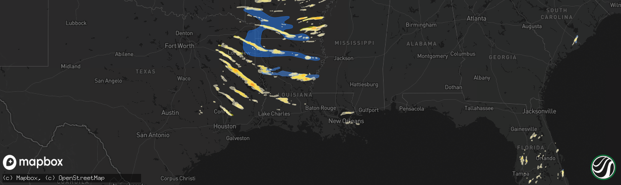
Hail
Wind
Tornado
16,640
Estimated number of impacted properties by a 1.00" hail or larger1,554
Estimated number of impacted properties by a 1.75" hail or larger0
Estimated number of impacted properties by a 2.50" hail or largerStorm reports in Louisiana
Louisiana
| Date | Description |
|---|---|
| 03/15/20266:55 PM CDT | Trees downed in heflin. |
| 03/15/20266:50 PM CDT | Trees downed in dixie inn. |
| 03/15/20266:24 PM CDT | Quarter size hail in the tiburon subdivision in north bossier. |
| 03/15/20266:23 PM CDT | Trees were downed along highway 80 in the eastwood/haughton area. |
| 03/15/20266:18 PM CDT | Quarter size hail on alder lane in north bossier. |
| 03/15/20266:16 PM CDT | A picture was posted to social media of quarter size hail that fell in the maplewood mobile home and rv park in north bossier city. |
| 03/15/20266:10 PM CDT | Report from mping: quarter |
| 03/15/20266:08 PM CDT | Trees down in shongaloo. |
| 03/15/20266:08 PM CDT | A tree was blown down across greenwood springridge road near blue nole road. |
| 03/15/20266:06 PM CDT | Quarter size hail measured just off old mooringsport road in the blanchard area between the middle and high schools. |
| 03/15/20266:05 PM CDT | A tree was downed across quiet acres road near blanchard. |
| 03/15/20266:05 PM CDT | Trees down near benton. |
| 03/15/20266:04 PM CDT | Trees down in plain dealing. |
| 03/15/20265:47 PM CDT | A tree was blown down across highway 538 near dawes road. |
| 03/15/20265:39 PM CDT | A tree was downed on highway 71 at hosston vivian road. |
| 03/15/20265:38 PM CDT | A tree was downed near the intersection of hosston rodessa road and mira myrtis road. |
| 03/15/20265:36 PM CDT | A tree was blown down between trees city road and pelican lodge road. |
| 03/15/20263:04 AM CDT | Knew recorded a wind gust of 60 mph. |
| 03/15/20263:01 AM CDT | Small tree down on marsha dr. |
| 03/15/20263:01 AM CDT | Delayed report: report of a tree down high winds caused by severe thunderstorms. Time estimated from radar. |
| 03/14/202610:24 PM CDT | A local report indicates 1.00 inch wind near Beaver |
| 03/14/202610:24 PM CDT | Tree and line down... Smart ln and harris road. |
| 03/14/202610:16 PM CDT | A local report indicates 1.00 inch wind near 3 SSE Oakdale |
| 03/14/202610:03 PM CDT | A local report indicates 1.75 inch wind near 7 S Jonesville |
| 03/14/202610:00 PM CDT | Multiple trees down and some across roads through the central part of the parish. |
| 03/14/20269:55 PM CDT | A local report indicates 1.75 inch wind near 4 WNW Wallace Ridge |
| 03/14/20269:45 PM CDT | Trees and power lines down across highway 28 east near cypress bayou south of catahoula lake near the catahoula parish line. |
| 03/14/20269:41 PM CDT | Trees and power lines down on highway 8 near the catahoula parish line. |
| 03/14/20269:40 PM CDT | Trees and power lines down on blade loop road near windmill road. |
| 03/14/20269:22 PM CDT | A tree was downed on east hardtner drive in the urania community. |
| 03/14/20269:22 PM CDT | A tree was downed at the la salle parish correctional center. |
| 03/14/20269:14 PM CDT | A few trees down along hwy 860 near union church road. |
| 03/14/20269:10 PM CDT | Tree down blocking highway 123 near the intersection of highway 165. |
| 03/14/20269:10 PM CDT | Tree down blocking lincecum church road near highway 165. |
| 03/14/20268:56 PM CDT | Tree down blocking the northbound lane of highway 167 near the intersection of highway 472 in the williana community. |
| 03/14/20268:53 PM CDT | Tree down on sylvan meadows loop. |
| 03/14/20268:45 PM CDT | Corrects previous hail report from chickasaw. Tree down along hwy 17. |
| 03/14/20268:45 PM CDT | Tree down along hwy 17. |
| 03/14/20268:41 PM CDT | A tree was down blocking gilcrease road near stinson road east of montgomery. |
| 03/14/20268:30 PM CDT | Tree down across highway 478 near page hill road. |
| 03/14/20268:27 PM CDT | Power lines were downed between swafford street and hall addition 1 in montgomery. |
| 03/14/20268:26 PM CDT | Tree down across both lanes of highway 501 near hubbard garrett road. |
| 03/14/20268:22 PM CDT | A tree was downed blocking both lanes of highway 71 near highway 477 in the saint maurice community. |
| 03/14/20268:21 PM CDT | Multiple trees and power lines were downed across ouachita parish. |
| 03/14/20268:14 PM CDT | Tree down across hart road northeast of campti. |
| 03/14/20268:10 PM CDT | A tree fell onto power lines in the brewtons mill community in northwest winn parish. |
| 03/14/20268:09 PM CDT | Tree down on highway 485 east of marthaville. |
| 03/14/20268:08 PM CDT | Trees down on highway 6 near robeline. |
| 03/14/20268:04 PM CDT | Tree down across highway 480 near campti. |
| 03/14/20267:58 PM CDT | Trees were downed near eros in the area of highways 144 and 158. |
| 03/14/20267:45 PM CDT | A power line was downed on mandy lane southwest of many near toledo bend lake. |
| 03/14/20267:37 PM CDT | A tree was downed on old pleasant hill road northeast of zwolle. |
| 03/14/20267:22 PM CDT | Several trees downed near the pelican community. |
| 03/14/20267:20 PM CDT | Trees and powerlines down throughout the town of arcadia. Time estimated by radar. |
| 03/14/20267:10 PM CDT | Trees and powerlines down throughout the town of gibsland. Time estimated by radar. |
| 03/14/20267:03 PM CDT | Quarter size hail fell in the rum center community north of spearsville. |
All States Impacted by Hail Map on March 15, 2026
Cities Impacted by Hail Map on March 15, 2026
- Woodburn, IA
- Osceola, IA
- Alexander, IL
- Ashland, IL
- New Berlin, IL
- Pleasant Plains, IL
- Beardstown, IL
- Hettick, IL
- Palmyra, IL
- Bath, IL
- Kilbourne, IL
- Havana, IL
- Chandlerville, IL
- Easton, IL
- Lewistown, IL
- Browning, IL
- Springfield, IL
- Forest City, IL
- Manito, IL
- Mason City, IL
- Riverside, IA
- Kalona, IA
- Iowa City, IA
- Hills, IA
- Lincoln, AR
- Fayetteville, AR
- Summers, AR
- Prairie Grove, AR
- Farmington, AR
- Springdale, AR
- Okeechobee, FL
- Palm Bay, FL
- Lorida, FL
- Kimberling City, MO
- Reeds Spring, MO
- Fellsmere, FL
- Punta Gorda, FL
- Fort Meade, FL
- Lake Wales, FL
- Frostproof, FL
- Malabar, FL
- Dade City, FL
- Grant, FL
- Wesley Chapel, FL
- San Antonio, FL
- Land O'Lakes, FL
- Melbourne, FL
- Washington, IA
- West Branch, IA
- Spring Hill, FL
- Brooksville, FL
- Bartow, FL
- Wauchula, FL
- Broken Bow, OK
- Davenport, FL
- Kissimmee, FL
- Sebastian, FL
- Harrison, AR
- Bowling Green, FL
- Webster, FL
- Ona, FL
- Parrish, FL
- Eagletown, OK
- Haines City, FL
- Polk City, FL
- Idabel, OK
- Garvin, OK
- Mountain Grove, MO
- Cabool, MO
- Yellville, AR
- Flippin, AR
- Summit, AR
- Vanzant, MO
- Drury, MO
- Lake Alfred, FL
- Floral City, FL
- Everton, AR
- Gillham, AR
- De Queen, AR
- Grand Saline, TX
- Solo, MO
- Elk Creek, MO
- Houston, MO
- Yukon, MO
- Eunice, MO
- Raymondville, MO
- Hartshorn, MO
- De Kalb, TX
- Mountain Home, AR
- Gassville, AR
- Midway, AR
- Cotter, AR
- Cuba, MO
- Leasburg, MO
- Van, TX
- Canton, TX
- Willow Springs, MO
- Mena, AR
- Winthrop, AR
- Saint Cloud, FL
- Alba, TX
- Saint James, MO
- Quitman, TX
- Mineola, TX
- Salem, MO
- Plainview, AR
- Jadwin, MO
- Perryville, AR
- Summersville, MO
- Tyler, TX
- Lindale, TX
- Caddo Gap, AR
- Langley, AR
- Elizabeth, AR
- Clarkridge, AR
- Gepp, AR
- Gamaliel, AR
- Henderson, AR
- Mims, FL
- Pittsburg, TX
- Umpire, AR
- Lockesburg, AR
- Dierks, AR
- Norman, AR
- Glenwood, AR
- Hawkins, TX
- Windermere, FL
- Apopka, FL
- Longwood, FL
- Lake Mary, FL
- Inverness, FL
- Big Sandy, TX
- Bakersfield, MO
- Caulfield, MO
- Nashville, AR
- Sanford, FL
- Orlando, FL
- New Smyrna Beach, FL
- Port Orange, FL
- Oak Hill, FL
- Viola, AR
- Salem, AR
- Daingerfield, TX
- Mount Pleasant, TX
- Virginia, IL
- Montverde, FL
- Gotha, FL
- Chandler, TX
- Brownsboro, TX
- Moody, MO
- Clermont, FL
- Kampsville, IL
- Hamburg, IL
- Eldred, IL
- Fieldon, IL
- Carrollton, IL
- Rockbridge, IL
- White Hall, IL
- Paron, AR
- Houston, AR
- Roland, AR
- Bigelow, AR
- Mayflower, AR
- Omaha, TX
- Bullard, TX
- Flint, TX
- Murfreesboro, AR
- Bunker, MO
- Bonnerdale, AR
- Gilmer, TX
- Amity, AR
- Saratoga, AR
- Texarkana, AR
- Texarkana, TX
- Ashdown, AR
- Lithia, FL
- Hughes Springs, TX
- Arp, TX
- Troup, TX
- Conway, AR
- Maumelle, AR
- North Little Rock, AR
- Jacksonville, TX
- Fulton, AR
- Avinger, TX
- Lone Star, TX
- Gladewater, TX
- Brandon, FL
- Washington, AR
- Saint Louis, MO
- Madison, IL
- East Saint Louis, IL
- Granite City, IL
- Venice, IL
- Linden, TX
- Jefferson, TX
- Higden, AR
- Edgemont, AR
- Prim, AR
- Palestine, TX
- Longview, TX
- Hope, AR
- Lewisville, AR
- Kilgore, TX
- White Oak, TX
- Elkhart, TX
- Florissant, MO
- Overton, TX
- Alton, MO
- Delight, AR
- Okolona, AR
- Garland City, AR
- Sherwood, AR
- Jacksonville, AR
- Vilonia, AR
- Cabot, AR
- Austin, AR
- El Paso, AR
- Hallsville, TX
- Malvern, AR
- Silver Springs, FL
- Loami, IL
- Chatham, IL
- Drasco, AR
- Stamps, AR
- Emmet, AR
- Grapeland, TX
- Centerville, TX
- Henderson, TX
- Selman City, TX
- East Alton, IL
- Wood River, IL
- Rusk, TX
- Reklaw, TX
- Fort McCoy, FL
- Cottage Hills, IL
- Roxana, IL
- Hartford, IL
- Bivins, TX
- Jefferson, AR
- Redfield, AR
- Anthony, FL
- Gurdon, AR
- Laneville, TX
- Cushing, TX
- Glen Carbon, IL
- Maryville, IL
- Collinsville, IL
- Troy, IL
- Moro, IL
- Bethalto, IL
- Vivian, LA
- Oil City, LA
- Hoxie, AR
- Alicia, AR
- Crockett, TX
- Buckner, AR
- Waldo, AR
- Sparkman, AR
- Warren, AR
- New Edinburg, AR
- Banks, AR
- Tatum, TX
- Fults, IL
- Arkadelphia, AR
- Crescent City, FL
- Sherrill, AR
- Altheimer, AR
- Tucker, AR
- Alexander, AR
- Ward, AR
- Sheridan, AR
- Traskwood, AR
- Benton, AR
- Karnack, TX
- Bono, AR
- Powhatan, AR
- Walnut Ridge, AR
- Strawberry, AR
- Lynn, AR
- Delaplaine, AR
- O'Kean, AR
- Beech Grove, AR
- Smithville, AR
- Pocahontas, AR
- Mooringsport, LA
- Lonoke, AR
- Lovelady, TX
- Somerville, TX
- Rison, AR
- Wilmar, AR
- Magnolia, AR
- McNeil, AR
- White Hall, AR
- Nacogdoches, TX
- Hensley, AR
- Humnoke, AR
- Wabbaseka, AR
- England, AR
- Douglass, TX
- West Alton, MO
- Beckville, TX
- Carthage, TX
- Bauxite, AR
- Shreveport, LA
- Belcher, LA
- Rosston, AR
- Camden, AR
- Benton, LA
- Monticello, AR
- Stephens, AR
- Garrison, TX
- Little Rock, AR
- Carlisle, AR
- Des Arc, AR
- Hazen, AR
- Hickory Plains, AR
- Brenham, TX
- Griffithville, AR
- Kennard, TX
- Mount Holly, AR
- El Dorado, AR
- Paragould, AR
- Lafe, AR
- Knobel, AR
- Marmaduke, AR
- Harrisburg, AR
- Cash, AR
- Swifton, AR
- Tuckerman, AR
- Weiner, AR
- Newport, AR
- Bay, AR
- Jonesboro, AR
- Trumann, AR
- State University, AR
- Brookland, AR
- Lake City, AR
- Bossier City, LA
- Haughton, LA
- Irving, IL
- Fillmore, IL
- Witt, IL
- Nokomis, IL
- Bingham, IL
- Ramsey, IL
- Rosamond, IL
- Ohlman, IL
- Pana, IL
- Oconee, IL
- Assumption, IL
- Shelbyville, IL
- Herrick, IL
- Tower Hill, IL
- Lakewood, IL
- Chireno, TX
- Stuttgart, AR
- Bedias, TX
- Huntsville, TX
- Trinity, TX
- Apple Springs, TX
- Groveton, TX
- Augusta, AR
- Hamburg, AR
- Blanchard, LA
- Biscoe, AR
- Beebe, AR
- Cotton Plant, AR
- Searcy, AR
- McCrory, AR
- Brinkley, AR
- Wheatley, AR
- Hunter, AR
- Palestine, AR
- Clarendon, AR
- Addieville, IL
- Marissa, IL
- Princeton, LA
- Okawville, IL
- Bartelso, IL
- Oakdale, IL
- New Baden, IL
- Nashville, IL
- Carlyle, IL
- Centralia, IL
- Hoyleton, IL
- Richview, IL
- Hoffman, IL
- Rector, AR
- Greenway, AR
- Piggott, AR
- Kennett, MO
- Saint Francis, AR
- Campbell, MO
- Malden, MO
- Gibson, MO
- Holcomb, MO
- Clarkton, MO
- Gideon, MO
- Black Oak, AR
- Monette, AR
- Leachville, AR
- Manila, AR
- Caraway, AR
- Arbyrd, MO
- Cardwell, MO
- Osceola, AR
- Etowah, AR
- Hornersville, MO
- Dell, AR
- Blytheville, AR
- Pine Bluff, AR
- Tillar, AR
- Oakhurst, TX
- Onalaska, TX
- Humphrey, AR
- Hermitage, AR
- Montrose, AR
- Corrigan, TX
- San Augustine, TX
- Lilbourn, MO
- Wardell, MO
- Portageville, MO
- Parma, MO
- Catron, MO
- Steele, MO
- Luxora, AR
- Dermott, AR
- Lake Village, AR
- Marston, MO
- Hughes, AR
- Proctor, AR
- Fountain Hill, AR
- Etoile, TX
- Star City, AR
- Minden, LA
- Pointblank, TX
- Livingston, TX
- De Witt, AR
- Saint Charles, AR
- Yorktown, AR
- Grady, AR
- Junction City, AR
- Willis, TX
- New Waverly, TX
- Logansport, LA
- Pickens, AR
- Winchester, AR
- Watson, AR
- McGehee, AR
- Rohwer, AR
- Strong, AR
- Wynne, AR
- Colt, AR
- Forrest City, AR
- Widener, AR
- Goodwin, AR
- Lillie, LA
- Summerfield, LA
- Bronson, TX
- Broaddus, TX
- Conroe, TX
- Chester, TX
- Athens, LA
- Dubberly, LA
- Gibsland, LA
- Louann, AR
- Benoit, MS
- Almyra, AR
- Marvell, AR
- Elaine, AR
- Holly Grove, AR
- Sibley, LA
- Doyline, LA
- Heflin, LA
- Mansfield, LA
- Grand Cane, LA
- Hernando, MS
- Tunica, MS
- Robinsonville, MS
- Lake Cormorant, MS
- Carbondale, IL
- Cambria, IL
- Marion, IL
- Carterville, IL
- De Soto, IL
- Herrin, IL
- Energy, IL
- Pittsburg, IL
- Johnston City, IL
- Windsor, IL
- Findlay, IL
- Bethany, IL
- Sullivan, IL
- Arthur, IL
- Arcola, IL
- Mattoon, IL
- Gays, IL
- Tuscola, IL
- Humboldt, IL
- Villa Grove, IL
- Camargo, IL
- Newman, IL
- Hume, IL
- Broadlands, IL
- Sidney, IL
- Murdock, IL
- Longview, IL
- Philo, IL
- Allerton, IL
- Homer, IL
- Sidell, IL
- Converse, LA
- Portland, AR
- Arcadia, LA
- Bienville, LA
- Woodville, TX
- Shepherd, TX
- Coldspring, TX
- Goodrich, TX
- Colmesneil, TX
- Lexa, AR
- Helena, AR
- Pineland, TX
- Shelbyville, TX
- Huttig, AR
- Greenville, MS
- Brookeland, TX
- Cleveland, TX
- Splendora, TX
- Pelican, LA
- Beulah, MS
- Mount Enterprise, TX
- Ruston, LA
- Simsboro, LA
- West Helena, AR
- Spearsville, LA
- Hemphill, TX
- Pleasant Hill, LA
- New Caney, TX
- Saratoga, TX
- Kountze, TX
- Wiergate, TX
- Indianola, IL
- Oakwood, IL
- Fairmount, IL
- Tilton, IL
- Fithian, IL
- Westville, IL
- Danville, IL
- Catlin, IL
- East Prairie, MO
- Clinton, KY
- Hickman, KY
- Arlington, KY
- Columbus, KY
- Bardwell, KY
- Marshall, TX
- Bloomburg, TX
- Doddridge, AR
- Fouke, AR
- Queen City, TX
- Maud, TX
- Douglassville, TX
- Harleton, TX
- Atlanta, TX
- Ida, LA
- Bradley, AR
- Rodessa, LA
- Taylor, AR
- Emerson, AR
- Hosston, LA
- Plain Dealing, LA
- Gilliam, LA
- Springhill, LA
- Louisville, IL
- Xenia, IL
- Sarepta, LA
- Shongaloo, LA
- Waskom, TX
- Cotton Valley, LA
- Greenwood, LA
- Bethany, LA
- De Berry, TX
- Prescott, AR
- Willisville, AR
- Chidester, AR
- Bluff City, AR
- Smackover, AR
- Hampton, AR
- Haynesville, LA
- Sarah, MS
- Belmont, LA
- Zwolle, LA
- Marthaville, LA
- Dundee, MS
- Rosedale, MS
- Ripley, MS
- Wilmot, AR
- Robeline, LA
- Coushatta, LA
- Crossett, AR
- Bastrop, LA
- Sledge, MS
- Bearden, AR
- Thornton, AR
- Calion, AR
- Homer, LA
- Keithville, LA
- Lisbon, LA
- Barksdale Afb, LA
- Bernice, LA
- Farmerville, LA
- Marion, LA
- Dubach, LA
- Elm Grove, LA
- Grambling, LA
- Stonewall, LA
- Ringgold, LA
- Jamestown, LA
- Quitman, LA
- Choudrant, LA
- Downsville, LA
- Calhoun, LA
- Monroe, LA
- Eros, LA
- West Monroe, LA
- Mangham, LA
- Oak Ridge, LA
- Rayville, LA
- Cooter, MO
- Caruthersville, MO
- Finley, TN
- Jones, LA
- Ramer, TN
- Selmer, TN
- Stantonville, TN
- Guys, TN
- Coldwater, MS
- Pocahontas, TN
- Corinth, MS
- Walnut, MS
- Leland, MS
- Spurger, TX
- Natchitoches, LA
- Many, LA
- Tiplersville, MS
- Huffman, TX
- Blevins, AR
- McCaskill, AR
- Ozan, AR
- Mineral Springs, AR
- Columbus, AR
- Horatio, AR
- Wilton, AR
- Ogden, AR
- Alleene, AR
- Eudora, AR
- Kirbyville, TX
- Burkeville, TX
- Michie, TN
- Bonita, LA
- Rienzi, MS
- Evans, LA
- Bismarck, IL
- Covington, IN
- Attica, IN
- West Lebanon, IN
- State Line, IN
- Williamsport, IN
- Shiloh, TN
- Counce, TN
- Savannah, TN
- Pontotoc, MS
- Ecru, MS
- Belden, MS
- Blue Springs, MS
- Leesville, LA
- Newton, TX
- Provencal, LA
- Fulton, KY
- South Fulton, TN
- Water Valley, KY
- Wingo, KY
- Sedalia, KY
- Mayfield, KY
- Farmington, KY
- Murray, KY
- Hazel, KY
- Almo, KY
- Adamsville, TN
- Lutts, TN
- Iuka, MS
- Burnsville, MS
- Waterloo, AL
- Crump, TN
- Morris Chapel, TN
- Waynesboro, TN
- Olivehill, TN
- Collinwood, TN
- Clifton, TN
- Dexter, KY
- Cadiz, KY
- New Concord, KY
- Big Rock, TN
- Dover, TN
- Bumpus Mills, TN
- Kirksey, KY
- Baskin, LA
- Tupelo, MS
- Saltillo, MS
- Guntown, MS
- Oak Grove, LA
- Hollandale, MS
- Glen, MS
- Deridder, LA
- Cypress Inn, TN
- Puryear, TN
- Palmersville, TN
- Cottage Grove, TN
- Paris, TN
- Buchanan, TN
- Springville, TN
- Big Sandy, TN
- Stewart, TN
- Cumberland City, TN
- Erin, TN
- Tennessee Ridge, TN
- Indian Mound, TN
- Martin, TN
- Dukedom, TN
- Dresden, TN
- Waverly, TN
- Gracey, KY
- La Fayette, KY
- Hopkinsville, KY
- Herndon, KY
- Fort Campbell, KY
- Benton, KY
- Hardin, KY
- Cerulean, KY
- Princeton, KY
- Crofton, KY
- Eddyville, KY
- Woodlawn, TN
- White Plains, KY
- Oak Grove, KY
- Pembroke, KY
- Palmyra, TN
- Linden, TN
- Anguilla, MS
- Dry Prong, LA
- Baldwyn, MS
- Booneville, MS
- Pitkin, LA
- Lyford, TX
- Winnsboro, LA
- Grayville, IL
- Shawneetown, IL
- Wadesville, IN
- Uniontown, KY
- Poseyville, IN
- New Harmony, IN
- Morganfield, KY
- Crossville, IL
- Henderson, KY
- Junction, IL
- Omaha, IL
- Ridgway, IL
- Norris City, IL
- Evansville, IN
- Waverly, KY
- Griffin, IN
- New Haven, IL
- Equality, IL
- Mount Vernon, IN
- Carmi, IL
- Corydon, KY
- Mount Carmel, IL
- Owensville, IN
- Princeton, IN
- Fort Branch, IN
- Haubstadt, IN
- Cynthiana, IN
- Richland, IN
- Elberfeld, IN
- Chandler, IN
- Spottsville, KY
- Rockport, IN
- Reed, KY
- Newburgh, IN
- Owensboro, KY
- Patoka, IN
- Boonville, IN
- Lynnville, IN
- Chrisney, IN
- Tennyson, IN
- Grandview, IN
- Francisco, IN
- Spurgeon, IN
- Velpen, IN
- Petersburg, IN
- Stendal, IN
- Gentryville, IN
- Oakland City, IN
- Hazleton, IN
- Winslow, IN
- Dale, IN
- Dubois, IN
- Holland, IN
- Santa Claus, IN
- Otwell, IN
- Lincoln City, IN
- Loogootee, IN
- Cannelburg, IN
- Ferdinand, IN
- Lamar, IN
- Washington, IN
- Jasper, IN
- Shoals, IN
- Huntingburg, IN
- Montgomery, IN
- Schnellville, IN
- Leopold, IN
- Cannelton, IN
- Taswell, IN
- English, IN
- Sulphur, IN
- Tell City, IN
- Evanston, IN
- Saint Meinrad, IN
- Troy, IN
- Birdseye, IN
- Celestine, IN
- French Lick, IN
- Saint Anthony, IN
- Branchville, IN
- Battletown, KY
- Grantsburg, IN
- Leavenworth, IN
- Bristow, IN
- Eckerty, IN
- Saint Croix, IN
- Monroe City, IN
- Parkersburg, IL
- Saint Francisville, IL
- Calhoun, IL
- Bridgeport, IL
- Bellmont, IL
- Sumner, IL
- Allendale, IL
- West Salem, IL
- Decker, IN
- Browns, IL
- Bone Gap, IL
- Albion, IL
- Claremont, IL
- Golden Gate, IL
- Burnt Prairie, IL
- Ellery, IL
- Wheatland, IN
- Flat Rock, IL
- Bruceville, IN
- Lawrenceville, IL
- Palestine, IL
- Oaktown, IN
- Vincennes, IN
- Hutsonville, IL
- Robinson, IL
- Dugger, IN
- Freelandville, IN
- Merom, IN
- Lyons, IN
- Coalmont, IN
- Sandborn, IN
- Linton, IN
- Farmersburg, IN
- Jasonville, IN
- Hymera, IN
- Elnora, IN
- Bicknell, IN
- Pimento, IN
- Fairbanks, IN
- Shelburn, IN
- Terre Haute, IN
- Plainville, IN
- Westphalia, IN
- Carlisle, IN
- Odon, IN
- Lewis, IN
- Edwardsport, IN
- West Union, IL
- Sullivan, IN
- Ragsdale, IN
- Owensburg, IN
- Clay City, IN
- Scotland, IN
- Freedom, IN
- Bloomfield, IN
- Williams, IN
- Newberry, IN
- Coal City, IN
- Switz City, IN
- Centerpoint, IN
- Bowling Green, IN
- Cory, IN
- Worthington, IN
- Paoli, IN
- West Baden Springs, IN
- Mitchell, IN
- Riley, IN
- Crane, IN
- Springville, IN
- Brazil, IN
- Carbon, IN
- Poland, IN
- Bedford, IN
- Staunton, IN
- Patricksburg, IN
- Knightsville, IN
- Marengo, IN
- Greencastle, IN
- Spencer, IN
- Harmony, IN
- Reelsville, IN
- Orleans, IN
- Solsberry, IN
- Bloomington, IN
- Hardinsburg, IN
- Cloverdale, IN
- Marietta, MS
- New Site, MS
- Tishomingo, MS
- Belzoni, MS
- Hurricane Mills, TN
- Lobelville, TN
- Pollock, LA
- Georgetown, LA
- Trout, LA
- Bentley, LA
- Delhi, LA
- Long Branch, TX
- Ellettsville, IN
- Lawrenceburg, TN
- San Perlita, TX
- Jena, LA
- Tallulah, LA
- Louise, MS
- Dennis, MS
- McEwen, TN
- Only, TN
- Dickson, TN
- Mayersville, MS
- Pioneer, LA
- Lake Providence, LA
- Sugartown, LA
- Dry Creek, LA
- Grant, LA
- Mittie, LA
- Jonesville, LA
- Cherokee, AL
- Parkdale, AR
- Summertown, TN
- Hohenwald, TN
- Charlotte, TN
- Nunnelly, TN
- Bon Aqua, TN
- Florence, AL
- Oakdale, LA
- Monterey, LA
- North Charleston, SC
- Kinder, LA
- Avoca, IN
- Martinsville, IN
- Gosport, IN
- Heltonville, IN
- Trafalgar, IN
- Nashville, IN
- Norman, IN
- Morgantown, IN
- Franklin, IN
- Bargersville, IN
- Unionville, IN
- Oolitic, IN
- Whiteland, IN
- Oberlin, LA
- Nesbit, MS
- Quincy, IN
- Clayton, IN
- Fillmore, IN
- Stinesville, IN
- Stilesville, IN
- Paragon, IN
- Monrovia, IN
- Coatesville, IN
- Mooresville, IN
- Greenwood, IN
- Danville, IN
- Avon, IN
- Brooklyn, IN
- Beech Grove, IN
- Carmel, IN
- Camby, IN
- Plainfield, IN
- Indianapolis, IN
- West Newton, IN
- Charleston, SC
- Needham, IN
- Nineveh, IN
- Fairland, IN
- Flat Rock, IN
- Columbus, IN
- Freetown, IN
- Boggstown, IN
- Edinburgh, IN
- Seymour, IN
- Taylorsville, IN
- Shelbyville, IN
- Tunnelton, IN
- Medora, IN
- Brownstown, IN
- Troy, TN
- Union City, TN
- Hornbeak, TN
- Rives, TN
- Obion, TN
- Ridgely, TN
- Dyersburg, TN
- Kenton, TN
- Newbern, TN
- Trimble, TN
- Halls, TN
- Lenox, TN
- Ripley, TN
- Friendship, TN
- Gates, TN
- Henning, TN
- Trenton, TN
- Dyer, TN
- Rutherford, TN
- Brownsville, TN
- Sharon, TN
- Covington, TN
- Stanton, TN
- Alamo, TN
- Mason, TN
- Bells, TN
- Gadsden, TN
- Greenfield, TN
- Bradford, TN
- Humboldt, TN
- Milan, TN
- Gleason, TN
- Atwood, TN
- McKenzie, TN
- Henry, TN
- Hartsville, IN
- Clifford, IN
- Hope, IN
- Westport, IN
- Mansfield, TN
- Eva, TN
- Burns, TN
- Vanleer, TN
- White Bluff, TN
- Browder, KY
- Beaver Dam, KY
- Elkton, KY
- Olmstead, KY
- Beechmont, KY
- Allensville, KY
- Greenville, KY
- Guthrie, KY
- Russellville, KY
- Southside, TN
- Sharon Grove, KY
- Lewisburg, KY
- Cumberland Furnace, TN
- Adams, TN
- Rochester, KY
- Chapmansboro, TN
- Drakesboro, KY
- Trenton, KY
- Cedar Hill, TN
- Beech Creek, KY
- Pleasant View, TN
- Morgantown, KY
- Cunningham, TN
- Adairville, KY
- Ashland City, TN
- Belton, KY
- Clarksville, TN
- Dunmor, KY
- Nashville, TN
- Gallatin, TN
- Cross Plains, TN
- Cottontown, TN
- Greenbrier, TN
- Hendersonville, TN
- Portland, TN
- Goodlettsville, TN
- Rockfield, KY
- Springfield, TN
- Kingston Springs, TN
- Auburn, KY
- Whites Creek, TN
- Woodburn, KY
- White House, TN
- Franklin, KY
- Pegram, TN
- Orlinda, TN
- Joelton, TN
- Bowling Green, KY
- McHenry, KY
- Hartford, KY
- Powderly, KY
- Central City, KY
- Rockport, KY
- Centertown, KY
- Cromwell, KY
- Bremen, KY
- Graham, KY
- Nortonville, KY
- Dawson Springs, KY
- Saint Charles, KY
- Madisonville, KY
- Horse Branch, KY
- Caneyville, KY
- Falls Of Rough, KY
- Fordsville, KY
- Jetson, KY
- Olaton, KY
- Dundee, KY
- Rosine, KY
- Brownsville, KY
- Roundhill, KY
- Millwood, KY
- Bee Spring, KY
- Leitchfield, KY
- Clarkson, KY
- Sweeden, KY
- Custer, KY
- Hudson, KY
- Eastview, KY
- Garfield, KY
- Westview, KY
- Big Clifty, KY
- Cecilia, KY
- McDaniels, KY
- Hardinsburg, KY
- Island, KY
- Sacramento, KY
- Mortons Gap, KY
- Vine Grove, KY
- Radcliff, KY
- Glendale, KY
- Elizabethtown, KY
- Rineyville, KY
- White Mills, KY
- Newellton, LA
- Iowa, LA
- Goose Creek, SC
- Ladson, SC
- Hanahan, SC
- Johns Island, SC
- Ravenel, SC
- Vidalia, LA
- Harrisonburg, LA
- Natchez, MS
- Summerville, SC
- Charleston Afb, SC
- Tuscumbia, AL
- Mount Pleasant, TN
- Ethridge, TN
- Ferriday, LA
- Moncks Corner, SC
- Killen, AL
- Sicily Island, LA
- Columbia, TN
- Sturkie, AR
- Bexar, AR
- Lexington, AL
- Loretto, TN
- Mamou, LA
- Saint Joseph, TN
- Hampshire, TN
- Eunice, LA
- Kennard, IN
- Greensburg, IN
- Arlington, IN
- Milroy, IN
- Shirley, IN
- Middletown, IN
- Mccordsville, IN
- Rushville, IN
- Saint Paul, IN
- Maxwell, IN
- Greenfield, IN
- New Palestine, IN
- Gwynneville, IN
- Fountaintown, IN
- Muncie, IN
- Lapel, IN
- Fishers, IN
- Charlottesville, IN
- Ingalls, IN
- Morristown, IN
- Pendleton, IN
- Fortville, IN
- Anderson, IN
- Noblesville, IN
- Homer, IN
- Markleville, IN
- Daleville, IN
- Wilkinson, IN
- Manilla, IN
- New Castle, IN
- Knightstown, IN
- Waldron, IN
- Carthage, IN
- Elwood, IN
- Frankton, IN
- Oldenburg, IN
- Laurel, IN
- Metamora, IN
- Mays, IN
- Spiceland, IN
- Connersville, IN
- Glenwood, IN
- Lewisville, IN
- Alexandria, IN
- Falmouth, IN
- Sunman, IN
- Brookville, IN
- Batesville, IN
- Osgood, IN
- Gaston, IN
- Jonesboro, IN
- Yorktown, IN
- Milton, IN
- Summitville, IN
- Straughn, IN
- Fowlerton, IN
- Cambridge City, IN
- Gas City, IN
- Fairmount, IN
- Springport, IN
- Mammoth Cave, KY
- Cub Run, KY
- Sonora, KY
- Horse Cave, KY
- Upton, KY
- Bonnieville, KY
- Munfordville, KY
- Shepherdsville, KY
- Hardyville, KY
- Boston, KY
- West Point, KY
- Hodgenville, KY
- Magnolia, KY
- Lebanon Junction, KY
- New Haven, KY
- Taylorsville, KY
- Clermont, KY
- Bardstown, KY
- Buffalo, KY
- Coxs Creek, KY
- Mount Washington, KY
- Saint Francis, KY
- Greensburg, KY
- Summersville, KY
- Lebanon, KY
- Springfield, KY
- New Hope, KY
- Campbellsville, KY
- Bloomfield, KY
- Canmer, KY
- Mount Sherman, KY
- Raywick, KY
- Loretto, KY
- Louisville, KY
- Fisherville, KY
- Fairfield, KY
- Simpsonville, KY
- Finchville, KY
- Chaplin, KY
- Lawrenceburg, KY
- Shelbyville, KY
- Harrodsburg, KY
- Perryville, KY
- Mount Eden, KY
- Gravel Switch, KY
- Saint Catharine, KY
- Willisburg, KY
- Bradfordsville, KY
- Mackville, KY
- Danville, KY
- Ville Platte, LA
- Opelousas, LA
- Roxie, MS
- Williamsport, TN
- Culleoka, TN
- Lewisburg, TN
- Spring Hill, TN
- Chapel Hill, TN
- College Grove, TN
- Eagleville, TN
- Church Point, LA
- Lebanon, TN
- Pulaski, TN
- Losantville, IN
- Mooreland, IN
- Upland, IN
- Hagerstown, IN
- Selma, IN
- Matthews, IN
- Westpoint, TN
- Iron City, TN
- Utica, KY
- Livermore, KY
- Whitesville, KY
- Cloverport, KY
- Reynolds Station, KY
- Stephensport, KY
- Harned, KY
- Irvington, KY
- Rhodelia, KY
- Ekron, KY
- Union Star, KY
- Guston, KY
- Payneville, KY
- Webster, KY
- Brandenburg, KY
- Mauckport, IN
- Laconia, IN
- Corydon, IN
- Fort Knox, KY
- Central, IN
- New Middletown, IN
- Brooks, KY
- Elizabeth, IN
- Muldraugh, KY
- Clarksville, IN
- Masonic Home, KY
- Fairdale, KY
- Lanesville, IN
- Greenville, IN
- Jeffersonville, IN
- New Albany, IN
- Floyds Knobs, IN
- Crandall, IN
- Georgetown, IN
- New Salisbury, IN
- Goshen, KY
- Prospect, KY
- Pewee Valley, KY
- Crestwood, KY
- Borden, IN
- Sellersburg, IN
- Glenview, KY
- Charlestown, IN
- Memphis, IN
- Westport, KY
- La Grange, KY
- Buckner, KY
- Nabb, IN
- Lexington, IN
- Marysville, IN
- Otisco, IN
- New Washington, IN
- Pendleton, KY
- Hanover, IN
- Milton, KY
- Smithfield, KY
- Bethlehem, IN
- Waddy, KY
- Bedford, KY
- Carrollton, KY
- Turners Station, KY
- Frankfort, KY
- Madison, IN
- Sulphur, KY
- Eminence, KY
- Campbellsburg, KY
- Salvisa, KY
- Vevay, IN
- Bagdad, KY
- Pleasureville, KY
- New Castle, KY
- Lockport, KY
- Stamping Ground, KY
- Lancaster, KY
- Nicholasville, KY
- Versailles, KY
- Ghent, KY
- Wilmore, KY
- Worthville, KY
- Owenton, KY
- Georgetown, KY
- Midway, KY
- Sanders, KY
- Perry Park, KY
- New Liberty, KY
- Lexington, KY
- Bethlehem, KY
- Burgin, KY
- Glencoe, KY
- Sadieville, KY
- Sparta, KY
- Jonesville, KY
- Warsaw, KY
- Corinth, KY
- Crittenden, KY
- Dry Ridge, KY
- Williamstown, KY
- Verona, KY
- Unionville, TN
- Christiana, TN
- Murfreesboro, TN
- Bell Buckle, TN
- Rockvale, TN
- Arrington, TN
- Smyrna, TN
- Lascassas, TN
- Milton, TN
- Watertown, TN
- Brush Creek, TN
- Liberty, TN
- Hickman, TN
- Auburntown, TN
- Alexandria, TN
- Woodbury, TN
- Readyville, TN
- Gordonsville, TN
- Riddleton, TN
- Carthage, TN
- Lancaster, TN
- Dowelltown, TN
- Buffalo Valley, TN
- Granville, TN
- Gainesboro, TN
- Whitleyville, TN
- Chestnut Mound, TN
- Elmwood, TN
- Pleasant Shade, TN
- Silver Point, TN
- Bloomington Springs, TN
- Smithville, TN
- Baxter, TN
- Port Barre, LA
- Goodspring, TN
- Cookeville, TN
- Rickman, TN
- Monterey, TN
- Hilham, TN
- Crawford, TN
- Livingston, TN
- Alpine, TN
- Clarkrange, TN
- Wilder, TN
- Grimsley, TN
- Allred, TN
- Allons, TN
- Monroe, TN
- Celina, TN
- Jamestown, TN
- Huntland, TN
- Prospect, TN
- Golden, MS
- Fulton, MS
- Fackler, AL
- Stevenson, AL
- Brighton, TN
- Atlanta, IN
- Atoka, TN
- Sparta, TN
- Beatrice, AL
- Fairfield Bay, AR
- Lacombe, LA
- Blue Mountain, MS
- Slidell, LA
- Marrero, LA
- Harvey, LA
- Forest Home, AL
- Saucier, MS
- Gretna, LA
- Belle Chasse, LA
- New Orleans, LA
- Braithwaite, LA
- Violet, LA
- Meraux, LA
- Saint Bernard, LA
- Vancleave, MS
- Perkinston, MS
- Valdosta, GA
- Moody Afb, GA
- Naylor, GA
- Lakeland, GA
- Wetumpka, AL
- Mobile, AL
- Semmes, AL
- Eight Mile, AL
- Wilmer, AL
- Hahira, GA
- Nashville, GA
- Adel, GA
- Evergreen, AL
- Saraland, AL
- Satsuma, AL
- Creola, AL
- Castleberry, AL
- Ray City, GA
- Red Level, AL
- Greenville, AL
- Georgiana, AL
- Hamilton, GA
- Shiloh, GA
- Woodland, GA
- Warm Springs, GA
- Manchester, GA
- Pine Mountain Valley, GA
- Woodbury, GA
- Molena, GA
- Thomaston, GA
- Bon Secour, AL
- Gulf Shores, AL
- Foley, AL
- Barnesville, GA
- Yatesville, GA
- The Rock, GA
- Meansville, GA
- Eufaula, AL
- Elberta, AL
- Greenville, SC
- Duncan, SC
- Greer, SC
- Macon, GA
- Abbeville, AL
- Harrison, GA
- Orland Park, IL
- Lockport, IL
- Tinley Park, IL
- Mokena, IL
- Oak Forest, IL
- New Lenox, IL
- Homer Glen, IL
- South Holland, IL
- Dolton, IL
- Riverdale, IL
- Blue Island, IL
- Calumet City, IL
- Edinburg, IL
- Pawnee, IL
- Homerville, GA
- Taylorville, IL
- Rochester, IL
- Palmer, IL
- Stonington, IL
- Morrisonville, IL
- Owaneco, IL
- White Pigeon, MI
- Howe, IN
- Sturgis, MI
- Shipshewana, IN
- Ballwin, MO
- Chesterfield, MO
- Lovejoy, IL
- Fenton, MO
- Valley Park, MO
- Eminence, MO
- Coffeen, IL
- Litchfield, IL
- Mount Olive, IL
- Hillsboro, IL
- Walshville, IL
- Staunton, IL
- Bunker Hill, IL
- Sorento, IL
- Alhambra, IL
- Butler, IL
- Livingston, IL
- Dorsey, IL
- Edwardsville, IL
- New Douglas, IL
- Hamel, IL
- Worden, IL
- Panama, IL
- Donnellson, IL
- Taylor Springs, IL
- Lenzburg, IL
- Saint Libory, IL
- Prairie Du Rocher, IL
- Coulterville, IL
- New Athens, IL
- Red Bud, IL
- Baldwin, IL
- Mascoutah, IL
- Sparta, IL
- Evansville, IL
- Lodi, MO
- Clubb, MO
- Greenville, MO
- Patterson, MO
- Silva, MO
- Marquand, MO
- Marble Hill, MO
- Oak Ridge, MO
- Jackson, MO
- Patton, MO
- Sedgewickville, MO
- Daisy, MO
- Millersville, MO
- Friedheim, MO
- Mechanicsburg, IL
- Divernon, IL
- Dawson, IL
- Waverly, IL
- Glenarm, IL
- Virden, IL
- Riverton, IL
- Auburn, IL
- Buffalo, IL
- Lincoln, IL
- Campti, LA
- Goldonna, LA
- Noble, LA
- Arcadia, IN
- Sheridan, IN
- Westfield, IN
- Tipton, IN
- Cicero, IN
- Atlanta, LA
- Natchez, LA
- Montgomery, LA
- Colfax, LA
- Winnfield, LA
- Clayton, LA
- Myrtle, MS
- Hickory Flat, MS
- Falkner, MS
- Walls, MS
- Olive Branch, MS
- West Memphis, AR
- Marion, AR
- Byhalia, MS
- Memphis, TN
- Southaven, MS
- Horn Lake, MS
- Senatobia, MS
- Holcomb, MS
- Grenada, MS
- Coffeeville, MS
- Bruce, MS
- Big Creek, MS
- Banner, MS
- Water Valley, MS
- Randolph, MS
- Houlka, MS
- Vardaman, MS
- Pittsboro, MS
- Leoma, TN
- Elkmont, AL
- Minor Hill, TN
- Anderson, AL
- Lester, AL
- Rogersville, AL
- Five Points, TN
- Athens, AL
- Sheffield, AL
- Muscle Shoals, AL
- Leighton, AL
- Town Creek, AL
- Whitley City, KY
- Parkers Lake, KY
- Russell Springs, KY
- Corbin, KY
- Somerset, KY
- Stearns, KY
- Ferguson, KY
- Bronston, KY
- Monticello, KY
- Burnside, KY
- Nancy, KY
- London, KY
- Woodbine, KY
- Gray, KY
- Keavy, KY
- Lily, KY
- Barbourville, KY
- Manchester, KY
- Calhoun City, MS
- Harpersville, AL
- Alpine, AL
- Sylacauga, AL
- Talladega, AL
- Vincent, AL
- Childersburg, AL
- Munford, AL
- Lineville, AL
- Oxford, AL
- Anniston, AL
- Lovington, IL


