Hail Map in Kentucky on March 15, 2026
The weather event in Kentucky on March 15, 2026 includes Hail, Wind, and Tornado maps. 16 states and 1,702 cities were impacted and suffered possible damage. The total estimated number of properties impacted is 0.
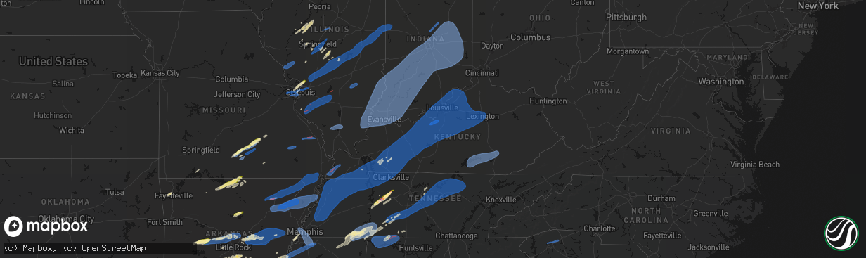
Hail
Wind
Tornado
0
Estimated number of impacted properties by a 1.00" hail or larger0
Estimated number of impacted properties by a 1.75" hail or larger0
Estimated number of impacted properties by a 2.50" hail or largerStorm reports in Kentucky
Kentucky
| Date | Description |
|---|---|
| 03/15/202610:30 AM CDT | Multiple power poles down on ky86 near vertrees church lane. |
| 03/15/20263:40 AM CDT | Tree on power lines. |
| 03/15/20263:25 AM CDT | Tree on power lines. |
| 03/15/20263:03 AM CDT | Tree down near the intersection of left fork abbott creek road and williams branch road. |
| 03/15/20262:40 AM CDT | Tree down around mile maker 3-4 along ky 699. Time estimated by radar. |
| 03/15/20262:20 AM CDT | Tree down near the intersection of artville road and dan ridge road. Time estimated by radar. |
| 03/15/20261:54 AM CDT | Tree down near 5824 furnace road. Time estimated by radar. |
| 03/15/20261:50 AM CDT | Tree down along little indian creek road and ky 6. Time estimated by radar. |
| 03/15/20261:50 AM CDT | Tree down along the road near the intersection of pompeii road and woody ware road. Time estimated by radar. |
| 03/15/20261:39 AM CDT | 2 trees were reported down on south wilderness trail |
| 03/15/20261:35 AM CDT | Large tree down on vaughn ridge road. |
| 03/15/20261:28 AM CDT | A tree was down on scaffold cane road near mile marker 3.6. |
| 03/15/20261:26 AM CDT | A tree was reported down on north wilderness road |
| 03/15/20261:20 AM CDT | A tree was reported down off of rich farm road just past the intersection of caldwell road. |
| 03/15/20261:16 AM CDT | Multiple trees down along ky 192 near ruth... Ky. Time estimated by radar. |
| 03/15/20261:10 AM CDT | A local report indicates 62 MPH wind near Lake Cumberland Regiona |
| 03/15/20261:09 AM CDT | Multiple trees down along ky 90. Report estimated by radar. |
| 03/15/20261:05 AM CDT | Tree down near ky 635 and ky 1676. Time estimated by radar. |
| 03/15/202612:54 AM CDT | Tree down near the intersection of ky 92 and ky 90. Time estimated by radar. |
| 03/15/202612:48 AM CDT | Tree down near woodland hl and hwy 90. Time estimated by radar. |
| 03/15/202612:45 AM CDT | Wind caused roof siding to rip off on a home 2 miles away from hwy 127 near hustonville. Not given cardinal direction away from hwy...so estimated location and time. |
| 03/15/202612:35 AM CDT | Report widespread tree damage in county. Concentrated area of damage along rice land and 738 as well as robert page road. Power poles leaning. Had some outdoor structur |
| 03/15/202612:25 AM CDT | Old building destroyed along 3108 headed towards salvation army camp. No other damage there. Also have a nearby tree down at sulphur creek road near mikes landing. Time |
| 03/15/202612:14 AM CDT | Tree down blocking the roadway at 4710 highway 55 s. |
| 03/15/202612:07 AM CDT | Tree down on the 1000 block of mcclelland circle. |
| 03/15/202612:06 AM CDT | Multiple trees down on stamping ground road near betsy way. |
| 03/15/202612:05 AM CDT | Tree down blocking cumberland parkway westbound. |
| 03/15/202612:00 AM CDT | Tree down on the 2400 block of bridgeport road. |
| 03/14/202611:55 PM CDT | Tree down in the road at boston and greensburg rd. Another tree reported down at columbia and mosby ridge. Time estimated from radar. |
| 03/14/202611:35 PM CDT | Mesonet station crop shelbyville 9 nne. |
| 03/14/202611:33 PM CDT | Tree down blocking entire road just off intersection of forrester and cleveland. |
| 03/14/202611:25 PM CDT | Mesonet station lgrn la grange 6 nw. |
| 03/14/202611:15 PM CDT | Awos station kbry bardstown. |
| 03/14/202611:08 PM CDT | Tree down on blossom rd. |
| 03/14/202611:05 PM CDT | Mesonet station crmt shepherdsville 6 se. |
| 03/14/202611:04 PM CDT | Multiple structures damaged along armstrong lane in mount washington as well as tree and power line damage. |
| 03/14/202611:01 PM CDT | Multiple trees and power lines down along ridge road east of shepherdsville. |
| 03/14/202610:52 PM CDT | Multiple trees down in lebanon junction. One tree was blown down onto a vehicle. |
| 03/14/202610:50 PM CDT | Tree down blocking holly drive near dennis way. |
| 03/14/202610:45 PM CDT | A local report indicates 77 MPH wind near 2 NW Radcliff |
| 03/14/202610:45 PM CDT | Measured at kekx. Report time of 20 minutes. Peak gust likely occurred before the standard 55 after. Estimated at 45 after from radar. |
| 03/14/202610:43 PM CDT | Large tree blown over. |
| 03/14/202610:43 PM CDT | Power lines across the roadway... Damage to multiple barns. |
| 03/14/202610:42 PM CDT | Railroad crossing gate broken off hinges on hayden school road. |
| 03/14/202610:41 PM CDT | Power poles down on ky 86 in cecilia. |
| 03/14/202610:41 PM CDT | Large tree on house. |
| 03/14/202610:41 PM CDT | Multiple buildings severely damaged... Power lines down and trees in the roadway. |
| 03/14/202610:40 PM CDT | 6200 block of rineyville-big springs road. House suffered roof damage with shingles and decking peeled back. Time based on radar data. |
| 03/14/202610:40 PM CDT | Reports of multiple trees down. |
| 03/14/202610:40 PM CDT | Bank sign damaged. |
| 03/14/202610:30 PM CDT | Corrects time on previous storm report from vertrees. Multiple power poles down on ky86 near vertrees church lane. |
| 03/14/202610:27 PM CDT | Few trees down on 86 but roadway is passable. Powerlines down on vertress near consstintine rd. Time estimated from radar. |
| 03/14/202610:25 PM CDT | Corrects previous tstm wnd dmg report from leitchfield. 30 trees down calls in leitchfield and about 4300 customers without power in grayson county. |
| 03/14/202610:25 PM CDT | Multiple trees down in leitchfield and about 1400 customers without power. |
| 03/14/202610:25 PM CDT | Mesonet station blrk leitchfield 3 w. |
| 03/14/202610:22 PM CDT | Reports of numerous trees down along hwy 84 near hardin springs. Time estimated from radar. |
| 03/14/202610:18 PM CDT | Mesonet station av189 leitchfield. |
| 03/14/202610:11 PM CDT | Large tree down on the 900 block of grancer road. |
| 03/14/202610:06 PM CDT | Damage to barns. |
| 03/14/202610:06 PM CDT | Damage to car port. |
| 03/14/202610:05 PM CDT | A local report indicates 68 MPH wind near 2 WSW Woodbury |
| 03/14/20269:48 PM CDT | A tree was blown down onto a house in the drakesboro area. |
| 03/14/20269:46 PM CDT | Tree in the roadway on hwy 431 north of central city. |
| 03/14/20269:40 PM CDT | Tree damaged mobile home in drakesboro. Metal blown off a business in greenville. |
| 03/14/20269:35 PM CDT | Awos station khop fort campbell ky. |
| 03/14/20269:19 PM CDT | A local report indicates 70 MPH wind near Pembroke |
| 03/14/20268:30 PM CDT | Pieces of metal blew off of two tobacco barns in kirksey. Several trees and power lines were downed over the county. Time estimated based on radar at kirksey. |
| 03/14/20268:19 PM CDT | Estimated wind north of cuba fire station. |
| 03/14/20268:05 PM CDT | Wind blew off side of outbuilding. Irrigation system blown over. |
| 03/14/20267:51 PM CDT | Two trees down in the oakton community. |
All States Impacted by Hail Map on March 15, 2026
Cities Impacted by Hail Map on March 15, 2026
- Woodburn, IA
- Osceola, IA
- Alexander, IL
- Ashland, IL
- New Berlin, IL
- Pleasant Plains, IL
- Beardstown, IL
- Hettick, IL
- Palmyra, IL
- Bath, IL
- Kilbourne, IL
- Havana, IL
- Chandlerville, IL
- Easton, IL
- Lewistown, IL
- Browning, IL
- Springfield, IL
- Forest City, IL
- Manito, IL
- Mason City, IL
- Riverside, IA
- Kalona, IA
- Iowa City, IA
- Hills, IA
- Lincoln, AR
- Fayetteville, AR
- Summers, AR
- Prairie Grove, AR
- Farmington, AR
- Springdale, AR
- Okeechobee, FL
- Palm Bay, FL
- Lorida, FL
- Kimberling City, MO
- Reeds Spring, MO
- Fellsmere, FL
- Punta Gorda, FL
- Fort Meade, FL
- Lake Wales, FL
- Frostproof, FL
- Malabar, FL
- Dade City, FL
- Grant, FL
- Wesley Chapel, FL
- San Antonio, FL
- Land O'Lakes, FL
- Melbourne, FL
- Washington, IA
- West Branch, IA
- Spring Hill, FL
- Brooksville, FL
- Bartow, FL
- Wauchula, FL
- Broken Bow, OK
- Davenport, FL
- Kissimmee, FL
- Sebastian, FL
- Harrison, AR
- Bowling Green, FL
- Webster, FL
- Ona, FL
- Parrish, FL
- Eagletown, OK
- Haines City, FL
- Polk City, FL
- Idabel, OK
- Garvin, OK
- Mountain Grove, MO
- Cabool, MO
- Yellville, AR
- Flippin, AR
- Summit, AR
- Vanzant, MO
- Drury, MO
- Lake Alfred, FL
- Floral City, FL
- Everton, AR
- Gillham, AR
- De Queen, AR
- Grand Saline, TX
- Solo, MO
- Elk Creek, MO
- Houston, MO
- Yukon, MO
- Eunice, MO
- Raymondville, MO
- Hartshorn, MO
- De Kalb, TX
- Mountain Home, AR
- Gassville, AR
- Midway, AR
- Cotter, AR
- Cuba, MO
- Leasburg, MO
- Van, TX
- Canton, TX
- Willow Springs, MO
- Mena, AR
- Winthrop, AR
- Saint Cloud, FL
- Alba, TX
- Saint James, MO
- Quitman, TX
- Mineola, TX
- Salem, MO
- Plainview, AR
- Jadwin, MO
- Perryville, AR
- Summersville, MO
- Tyler, TX
- Lindale, TX
- Caddo Gap, AR
- Langley, AR
- Elizabeth, AR
- Clarkridge, AR
- Gepp, AR
- Gamaliel, AR
- Henderson, AR
- Mims, FL
- Pittsburg, TX
- Umpire, AR
- Lockesburg, AR
- Dierks, AR
- Norman, AR
- Glenwood, AR
- Hawkins, TX
- Windermere, FL
- Apopka, FL
- Longwood, FL
- Lake Mary, FL
- Inverness, FL
- Big Sandy, TX
- Bakersfield, MO
- Caulfield, MO
- Nashville, AR
- Sanford, FL
- Orlando, FL
- New Smyrna Beach, FL
- Port Orange, FL
- Oak Hill, FL
- Viola, AR
- Salem, AR
- Daingerfield, TX
- Mount Pleasant, TX
- Virginia, IL
- Montverde, FL
- Gotha, FL
- Chandler, TX
- Brownsboro, TX
- Moody, MO
- Clermont, FL
- Kampsville, IL
- Hamburg, IL
- Eldred, IL
- Fieldon, IL
- Carrollton, IL
- Rockbridge, IL
- White Hall, IL
- Paron, AR
- Houston, AR
- Roland, AR
- Bigelow, AR
- Mayflower, AR
- Omaha, TX
- Bullard, TX
- Flint, TX
- Murfreesboro, AR
- Bunker, MO
- Bonnerdale, AR
- Gilmer, TX
- Amity, AR
- Saratoga, AR
- Texarkana, AR
- Texarkana, TX
- Ashdown, AR
- Lithia, FL
- Hughes Springs, TX
- Arp, TX
- Troup, TX
- Conway, AR
- Maumelle, AR
- North Little Rock, AR
- Jacksonville, TX
- Fulton, AR
- Avinger, TX
- Lone Star, TX
- Gladewater, TX
- Brandon, FL
- Washington, AR
- Saint Louis, MO
- Madison, IL
- East Saint Louis, IL
- Granite City, IL
- Venice, IL
- Linden, TX
- Jefferson, TX
- Higden, AR
- Edgemont, AR
- Prim, AR
- Palestine, TX
- Longview, TX
- Hope, AR
- Lewisville, AR
- Kilgore, TX
- White Oak, TX
- Elkhart, TX
- Florissant, MO
- Overton, TX
- Alton, MO
- Delight, AR
- Okolona, AR
- Garland City, AR
- Sherwood, AR
- Jacksonville, AR
- Vilonia, AR
- Cabot, AR
- Austin, AR
- El Paso, AR
- Hallsville, TX
- Malvern, AR
- Silver Springs, FL
- Loami, IL
- Chatham, IL
- Drasco, AR
- Stamps, AR
- Emmet, AR
- Grapeland, TX
- Centerville, TX
- Henderson, TX
- Selman City, TX
- East Alton, IL
- Wood River, IL
- Rusk, TX
- Reklaw, TX
- Fort McCoy, FL
- Cottage Hills, IL
- Roxana, IL
- Hartford, IL
- Bivins, TX
- Jefferson, AR
- Redfield, AR
- Anthony, FL
- Gurdon, AR
- Laneville, TX
- Cushing, TX
- Glen Carbon, IL
- Maryville, IL
- Collinsville, IL
- Troy, IL
- Moro, IL
- Bethalto, IL
- Vivian, LA
- Oil City, LA
- Hoxie, AR
- Alicia, AR
- Crockett, TX
- Buckner, AR
- Waldo, AR
- Sparkman, AR
- Warren, AR
- New Edinburg, AR
- Banks, AR
- Tatum, TX
- Fults, IL
- Arkadelphia, AR
- Crescent City, FL
- Sherrill, AR
- Altheimer, AR
- Tucker, AR
- Alexander, AR
- Ward, AR
- Sheridan, AR
- Traskwood, AR
- Benton, AR
- Karnack, TX
- Bono, AR
- Powhatan, AR
- Walnut Ridge, AR
- Strawberry, AR
- Lynn, AR
- Delaplaine, AR
- O'Kean, AR
- Beech Grove, AR
- Smithville, AR
- Pocahontas, AR
- Mooringsport, LA
- Lonoke, AR
- Lovelady, TX
- Somerville, TX
- Rison, AR
- Wilmar, AR
- Magnolia, AR
- McNeil, AR
- White Hall, AR
- Nacogdoches, TX
- Hensley, AR
- Humnoke, AR
- Wabbaseka, AR
- England, AR
- Douglass, TX
- West Alton, MO
- Beckville, TX
- Carthage, TX
- Bauxite, AR
- Shreveport, LA
- Belcher, LA
- Rosston, AR
- Camden, AR
- Benton, LA
- Monticello, AR
- Stephens, AR
- Garrison, TX
- Little Rock, AR
- Carlisle, AR
- Des Arc, AR
- Hazen, AR
- Hickory Plains, AR
- Brenham, TX
- Griffithville, AR
- Kennard, TX
- Mount Holly, AR
- El Dorado, AR
- Paragould, AR
- Lafe, AR
- Knobel, AR
- Marmaduke, AR
- Harrisburg, AR
- Cash, AR
- Swifton, AR
- Tuckerman, AR
- Weiner, AR
- Newport, AR
- Bay, AR
- Jonesboro, AR
- Trumann, AR
- State University, AR
- Brookland, AR
- Lake City, AR
- Bossier City, LA
- Haughton, LA
- Irving, IL
- Fillmore, IL
- Witt, IL
- Nokomis, IL
- Bingham, IL
- Ramsey, IL
- Rosamond, IL
- Ohlman, IL
- Pana, IL
- Oconee, IL
- Assumption, IL
- Shelbyville, IL
- Herrick, IL
- Tower Hill, IL
- Lakewood, IL
- Chireno, TX
- Stuttgart, AR
- Bedias, TX
- Huntsville, TX
- Trinity, TX
- Apple Springs, TX
- Groveton, TX
- Augusta, AR
- Hamburg, AR
- Blanchard, LA
- Biscoe, AR
- Beebe, AR
- Cotton Plant, AR
- Searcy, AR
- McCrory, AR
- Brinkley, AR
- Wheatley, AR
- Hunter, AR
- Palestine, AR
- Clarendon, AR
- Addieville, IL
- Marissa, IL
- Princeton, LA
- Okawville, IL
- Bartelso, IL
- Oakdale, IL
- New Baden, IL
- Nashville, IL
- Carlyle, IL
- Centralia, IL
- Hoyleton, IL
- Richview, IL
- Hoffman, IL
- Rector, AR
- Greenway, AR
- Piggott, AR
- Kennett, MO
- Saint Francis, AR
- Campbell, MO
- Malden, MO
- Gibson, MO
- Holcomb, MO
- Clarkton, MO
- Gideon, MO
- Black Oak, AR
- Monette, AR
- Leachville, AR
- Manila, AR
- Caraway, AR
- Arbyrd, MO
- Cardwell, MO
- Osceola, AR
- Etowah, AR
- Hornersville, MO
- Dell, AR
- Blytheville, AR
- Pine Bluff, AR
- Tillar, AR
- Oakhurst, TX
- Onalaska, TX
- Humphrey, AR
- Hermitage, AR
- Montrose, AR
- Corrigan, TX
- San Augustine, TX
- Lilbourn, MO
- Wardell, MO
- Portageville, MO
- Parma, MO
- Catron, MO
- Steele, MO
- Luxora, AR
- Dermott, AR
- Lake Village, AR
- Marston, MO
- Hughes, AR
- Proctor, AR
- Fountain Hill, AR
- Etoile, TX
- Star City, AR
- Minden, LA
- Pointblank, TX
- Livingston, TX
- De Witt, AR
- Saint Charles, AR
- Yorktown, AR
- Grady, AR
- Junction City, AR
- Willis, TX
- New Waverly, TX
- Logansport, LA
- Pickens, AR
- Winchester, AR
- Watson, AR
- McGehee, AR
- Rohwer, AR
- Strong, AR
- Wynne, AR
- Colt, AR
- Forrest City, AR
- Widener, AR
- Goodwin, AR
- Lillie, LA
- Summerfield, LA
- Bronson, TX
- Broaddus, TX
- Conroe, TX
- Chester, TX
- Athens, LA
- Dubberly, LA
- Gibsland, LA
- Louann, AR
- Benoit, MS
- Almyra, AR
- Marvell, AR
- Elaine, AR
- Holly Grove, AR
- Sibley, LA
- Doyline, LA
- Heflin, LA
- Mansfield, LA
- Grand Cane, LA
- Hernando, MS
- Tunica, MS
- Robinsonville, MS
- Lake Cormorant, MS
- Carbondale, IL
- Cambria, IL
- Marion, IL
- Carterville, IL
- De Soto, IL
- Herrin, IL
- Energy, IL
- Pittsburg, IL
- Johnston City, IL
- Windsor, IL
- Findlay, IL
- Bethany, IL
- Sullivan, IL
- Arthur, IL
- Arcola, IL
- Mattoon, IL
- Gays, IL
- Tuscola, IL
- Humboldt, IL
- Villa Grove, IL
- Camargo, IL
- Newman, IL
- Hume, IL
- Broadlands, IL
- Sidney, IL
- Murdock, IL
- Longview, IL
- Philo, IL
- Allerton, IL
- Homer, IL
- Sidell, IL
- Converse, LA
- Portland, AR
- Arcadia, LA
- Bienville, LA
- Woodville, TX
- Shepherd, TX
- Coldspring, TX
- Goodrich, TX
- Colmesneil, TX
- Lexa, AR
- Helena, AR
- Pineland, TX
- Shelbyville, TX
- Huttig, AR
- Greenville, MS
- Brookeland, TX
- Cleveland, TX
- Splendora, TX
- Pelican, LA
- Beulah, MS
- Mount Enterprise, TX
- Ruston, LA
- Simsboro, LA
- West Helena, AR
- Spearsville, LA
- Hemphill, TX
- Pleasant Hill, LA
- New Caney, TX
- Saratoga, TX
- Kountze, TX
- Wiergate, TX
- Indianola, IL
- Oakwood, IL
- Fairmount, IL
- Tilton, IL
- Fithian, IL
- Westville, IL
- Danville, IL
- Catlin, IL
- East Prairie, MO
- Clinton, KY
- Hickman, KY
- Arlington, KY
- Columbus, KY
- Bardwell, KY
- Marshall, TX
- Bloomburg, TX
- Doddridge, AR
- Fouke, AR
- Queen City, TX
- Maud, TX
- Douglassville, TX
- Harleton, TX
- Atlanta, TX
- Ida, LA
- Bradley, AR
- Rodessa, LA
- Taylor, AR
- Emerson, AR
- Hosston, LA
- Plain Dealing, LA
- Gilliam, LA
- Springhill, LA
- Louisville, IL
- Xenia, IL
- Sarepta, LA
- Shongaloo, LA
- Waskom, TX
- Cotton Valley, LA
- Greenwood, LA
- Bethany, LA
- De Berry, TX
- Prescott, AR
- Willisville, AR
- Chidester, AR
- Bluff City, AR
- Smackover, AR
- Hampton, AR
- Haynesville, LA
- Sarah, MS
- Belmont, LA
- Zwolle, LA
- Marthaville, LA
- Dundee, MS
- Rosedale, MS
- Ripley, MS
- Wilmot, AR
- Robeline, LA
- Coushatta, LA
- Crossett, AR
- Bastrop, LA
- Sledge, MS
- Bearden, AR
- Thornton, AR
- Calion, AR
- Homer, LA
- Keithville, LA
- Lisbon, LA
- Barksdale Afb, LA
- Bernice, LA
- Farmerville, LA
- Marion, LA
- Dubach, LA
- Elm Grove, LA
- Grambling, LA
- Stonewall, LA
- Ringgold, LA
- Jamestown, LA
- Quitman, LA
- Choudrant, LA
- Downsville, LA
- Calhoun, LA
- Monroe, LA
- Eros, LA
- West Monroe, LA
- Mangham, LA
- Oak Ridge, LA
- Rayville, LA
- Cooter, MO
- Caruthersville, MO
- Finley, TN
- Jones, LA
- Ramer, TN
- Selmer, TN
- Stantonville, TN
- Guys, TN
- Coldwater, MS
- Pocahontas, TN
- Corinth, MS
- Walnut, MS
- Leland, MS
- Spurger, TX
- Natchitoches, LA
- Many, LA
- Tiplersville, MS
- Huffman, TX
- Blevins, AR
- McCaskill, AR
- Ozan, AR
- Mineral Springs, AR
- Columbus, AR
- Horatio, AR
- Wilton, AR
- Ogden, AR
- Alleene, AR
- Eudora, AR
- Kirbyville, TX
- Burkeville, TX
- Michie, TN
- Bonita, LA
- Rienzi, MS
- Evans, LA
- Bismarck, IL
- Covington, IN
- Attica, IN
- West Lebanon, IN
- State Line, IN
- Williamsport, IN
- Shiloh, TN
- Counce, TN
- Savannah, TN
- Pontotoc, MS
- Ecru, MS
- Belden, MS
- Blue Springs, MS
- Leesville, LA
- Newton, TX
- Provencal, LA
- Fulton, KY
- South Fulton, TN
- Water Valley, KY
- Wingo, KY
- Sedalia, KY
- Mayfield, KY
- Farmington, KY
- Murray, KY
- Hazel, KY
- Almo, KY
- Adamsville, TN
- Lutts, TN
- Iuka, MS
- Burnsville, MS
- Waterloo, AL
- Crump, TN
- Morris Chapel, TN
- Waynesboro, TN
- Olivehill, TN
- Collinwood, TN
- Clifton, TN
- Dexter, KY
- Cadiz, KY
- New Concord, KY
- Big Rock, TN
- Dover, TN
- Bumpus Mills, TN
- Kirksey, KY
- Baskin, LA
- Tupelo, MS
- Saltillo, MS
- Guntown, MS
- Oak Grove, LA
- Hollandale, MS
- Glen, MS
- Deridder, LA
- Cypress Inn, TN
- Puryear, TN
- Palmersville, TN
- Cottage Grove, TN
- Paris, TN
- Buchanan, TN
- Springville, TN
- Big Sandy, TN
- Stewart, TN
- Cumberland City, TN
- Erin, TN
- Tennessee Ridge, TN
- Indian Mound, TN
- Martin, TN
- Dukedom, TN
- Dresden, TN
- Waverly, TN
- Gracey, KY
- La Fayette, KY
- Hopkinsville, KY
- Herndon, KY
- Fort Campbell, KY
- Benton, KY
- Hardin, KY
- Cerulean, KY
- Princeton, KY
- Crofton, KY
- Eddyville, KY
- Woodlawn, TN
- White Plains, KY
- Oak Grove, KY
- Pembroke, KY
- Palmyra, TN
- Linden, TN
- Anguilla, MS
- Dry Prong, LA
- Baldwyn, MS
- Booneville, MS
- Pitkin, LA
- Lyford, TX
- Winnsboro, LA
- Grayville, IL
- Shawneetown, IL
- Wadesville, IN
- Uniontown, KY
- Poseyville, IN
- New Harmony, IN
- Morganfield, KY
- Crossville, IL
- Henderson, KY
- Junction, IL
- Omaha, IL
- Ridgway, IL
- Norris City, IL
- Evansville, IN
- Waverly, KY
- Griffin, IN
- New Haven, IL
- Equality, IL
- Mount Vernon, IN
- Carmi, IL
- Corydon, KY
- Mount Carmel, IL
- Owensville, IN
- Princeton, IN
- Fort Branch, IN
- Haubstadt, IN
- Cynthiana, IN
- Richland, IN
- Elberfeld, IN
- Chandler, IN
- Spottsville, KY
- Rockport, IN
- Reed, KY
- Newburgh, IN
- Owensboro, KY
- Patoka, IN
- Boonville, IN
- Lynnville, IN
- Chrisney, IN
- Tennyson, IN
- Grandview, IN
- Francisco, IN
- Spurgeon, IN
- Velpen, IN
- Petersburg, IN
- Stendal, IN
- Gentryville, IN
- Oakland City, IN
- Hazleton, IN
- Winslow, IN
- Dale, IN
- Dubois, IN
- Holland, IN
- Santa Claus, IN
- Otwell, IN
- Lincoln City, IN
- Loogootee, IN
- Cannelburg, IN
- Ferdinand, IN
- Lamar, IN
- Washington, IN
- Jasper, IN
- Shoals, IN
- Huntingburg, IN
- Montgomery, IN
- Schnellville, IN
- Leopold, IN
- Cannelton, IN
- Taswell, IN
- English, IN
- Sulphur, IN
- Tell City, IN
- Evanston, IN
- Saint Meinrad, IN
- Troy, IN
- Birdseye, IN
- Celestine, IN
- French Lick, IN
- Saint Anthony, IN
- Branchville, IN
- Battletown, KY
- Grantsburg, IN
- Leavenworth, IN
- Bristow, IN
- Eckerty, IN
- Saint Croix, IN
- Monroe City, IN
- Parkersburg, IL
- Saint Francisville, IL
- Calhoun, IL
- Bridgeport, IL
- Bellmont, IL
- Sumner, IL
- Allendale, IL
- West Salem, IL
- Decker, IN
- Browns, IL
- Bone Gap, IL
- Albion, IL
- Claremont, IL
- Golden Gate, IL
- Burnt Prairie, IL
- Ellery, IL
- Wheatland, IN
- Flat Rock, IL
- Bruceville, IN
- Lawrenceville, IL
- Palestine, IL
- Oaktown, IN
- Vincennes, IN
- Hutsonville, IL
- Robinson, IL
- Dugger, IN
- Freelandville, IN
- Merom, IN
- Lyons, IN
- Coalmont, IN
- Sandborn, IN
- Linton, IN
- Farmersburg, IN
- Jasonville, IN
- Hymera, IN
- Elnora, IN
- Bicknell, IN
- Pimento, IN
- Fairbanks, IN
- Shelburn, IN
- Terre Haute, IN
- Plainville, IN
- Westphalia, IN
- Carlisle, IN
- Odon, IN
- Lewis, IN
- Edwardsport, IN
- West Union, IL
- Sullivan, IN
- Ragsdale, IN
- Owensburg, IN
- Clay City, IN
- Scotland, IN
- Freedom, IN
- Bloomfield, IN
- Williams, IN
- Newberry, IN
- Coal City, IN
- Switz City, IN
- Centerpoint, IN
- Bowling Green, IN
- Cory, IN
- Worthington, IN
- Paoli, IN
- West Baden Springs, IN
- Mitchell, IN
- Riley, IN
- Crane, IN
- Springville, IN
- Brazil, IN
- Carbon, IN
- Poland, IN
- Bedford, IN
- Staunton, IN
- Patricksburg, IN
- Knightsville, IN
- Marengo, IN
- Greencastle, IN
- Spencer, IN
- Harmony, IN
- Reelsville, IN
- Orleans, IN
- Solsberry, IN
- Bloomington, IN
- Hardinsburg, IN
- Cloverdale, IN
- Marietta, MS
- New Site, MS
- Tishomingo, MS
- Belzoni, MS
- Hurricane Mills, TN
- Lobelville, TN
- Pollock, LA
- Georgetown, LA
- Trout, LA
- Bentley, LA
- Delhi, LA
- Long Branch, TX
- Ellettsville, IN
- Lawrenceburg, TN
- San Perlita, TX
- Jena, LA
- Tallulah, LA
- Louise, MS
- Dennis, MS
- McEwen, TN
- Only, TN
- Dickson, TN
- Mayersville, MS
- Pioneer, LA
- Lake Providence, LA
- Sugartown, LA
- Dry Creek, LA
- Grant, LA
- Mittie, LA
- Jonesville, LA
- Cherokee, AL
- Parkdale, AR
- Summertown, TN
- Hohenwald, TN
- Charlotte, TN
- Nunnelly, TN
- Bon Aqua, TN
- Florence, AL
- Oakdale, LA
- Monterey, LA
- North Charleston, SC
- Kinder, LA
- Avoca, IN
- Martinsville, IN
- Gosport, IN
- Heltonville, IN
- Trafalgar, IN
- Nashville, IN
- Norman, IN
- Morgantown, IN
- Franklin, IN
- Bargersville, IN
- Unionville, IN
- Oolitic, IN
- Whiteland, IN
- Oberlin, LA
- Nesbit, MS
- Quincy, IN
- Clayton, IN
- Fillmore, IN
- Stinesville, IN
- Stilesville, IN
- Paragon, IN
- Monrovia, IN
- Coatesville, IN
- Mooresville, IN
- Greenwood, IN
- Danville, IN
- Avon, IN
- Brooklyn, IN
- Beech Grove, IN
- Carmel, IN
- Camby, IN
- Plainfield, IN
- Indianapolis, IN
- West Newton, IN
- Charleston, SC
- Needham, IN
- Nineveh, IN
- Fairland, IN
- Flat Rock, IN
- Columbus, IN
- Freetown, IN
- Boggstown, IN
- Edinburgh, IN
- Seymour, IN
- Taylorsville, IN
- Shelbyville, IN
- Tunnelton, IN
- Medora, IN
- Brownstown, IN
- Troy, TN
- Union City, TN
- Hornbeak, TN
- Rives, TN
- Obion, TN
- Ridgely, TN
- Dyersburg, TN
- Kenton, TN
- Newbern, TN
- Trimble, TN
- Halls, TN
- Lenox, TN
- Ripley, TN
- Friendship, TN
- Gates, TN
- Henning, TN
- Trenton, TN
- Dyer, TN
- Rutherford, TN
- Brownsville, TN
- Sharon, TN
- Covington, TN
- Stanton, TN
- Alamo, TN
- Mason, TN
- Bells, TN
- Gadsden, TN
- Greenfield, TN
- Bradford, TN
- Humboldt, TN
- Milan, TN
- Gleason, TN
- Atwood, TN
- McKenzie, TN
- Henry, TN
- Hartsville, IN
- Clifford, IN
- Hope, IN
- Westport, IN
- Mansfield, TN
- Eva, TN
- Burns, TN
- Vanleer, TN
- White Bluff, TN
- Browder, KY
- Beaver Dam, KY
- Elkton, KY
- Olmstead, KY
- Beechmont, KY
- Allensville, KY
- Greenville, KY
- Guthrie, KY
- Russellville, KY
- Southside, TN
- Sharon Grove, KY
- Lewisburg, KY
- Cumberland Furnace, TN
- Adams, TN
- Rochester, KY
- Chapmansboro, TN
- Drakesboro, KY
- Trenton, KY
- Cedar Hill, TN
- Beech Creek, KY
- Pleasant View, TN
- Morgantown, KY
- Cunningham, TN
- Adairville, KY
- Ashland City, TN
- Belton, KY
- Clarksville, TN
- Dunmor, KY
- Nashville, TN
- Gallatin, TN
- Cross Plains, TN
- Cottontown, TN
- Greenbrier, TN
- Hendersonville, TN
- Portland, TN
- Goodlettsville, TN
- Rockfield, KY
- Springfield, TN
- Kingston Springs, TN
- Auburn, KY
- Whites Creek, TN
- Woodburn, KY
- White House, TN
- Franklin, KY
- Pegram, TN
- Orlinda, TN
- Joelton, TN
- Bowling Green, KY
- McHenry, KY
- Hartford, KY
- Powderly, KY
- Central City, KY
- Rockport, KY
- Centertown, KY
- Cromwell, KY
- Bremen, KY
- Graham, KY
- Nortonville, KY
- Dawson Springs, KY
- Saint Charles, KY
- Madisonville, KY
- Horse Branch, KY
- Caneyville, KY
- Falls Of Rough, KY
- Fordsville, KY
- Jetson, KY
- Olaton, KY
- Dundee, KY
- Rosine, KY
- Brownsville, KY
- Roundhill, KY
- Millwood, KY
- Bee Spring, KY
- Leitchfield, KY
- Clarkson, KY
- Sweeden, KY
- Custer, KY
- Hudson, KY
- Eastview, KY
- Garfield, KY
- Westview, KY
- Big Clifty, KY
- Cecilia, KY
- McDaniels, KY
- Hardinsburg, KY
- Island, KY
- Sacramento, KY
- Mortons Gap, KY
- Vine Grove, KY
- Radcliff, KY
- Glendale, KY
- Elizabethtown, KY
- Rineyville, KY
- White Mills, KY
- Newellton, LA
- Iowa, LA
- Goose Creek, SC
- Ladson, SC
- Hanahan, SC
- Johns Island, SC
- Ravenel, SC
- Vidalia, LA
- Harrisonburg, LA
- Natchez, MS
- Summerville, SC
- Charleston Afb, SC
- Tuscumbia, AL
- Mount Pleasant, TN
- Ethridge, TN
- Ferriday, LA
- Moncks Corner, SC
- Killen, AL
- Sicily Island, LA
- Columbia, TN
- Sturkie, AR
- Bexar, AR
- Lexington, AL
- Loretto, TN
- Mamou, LA
- Saint Joseph, TN
- Hampshire, TN
- Eunice, LA
- Kennard, IN
- Greensburg, IN
- Arlington, IN
- Milroy, IN
- Shirley, IN
- Middletown, IN
- Mccordsville, IN
- Rushville, IN
- Saint Paul, IN
- Maxwell, IN
- Greenfield, IN
- New Palestine, IN
- Gwynneville, IN
- Fountaintown, IN
- Muncie, IN
- Lapel, IN
- Fishers, IN
- Charlottesville, IN
- Ingalls, IN
- Morristown, IN
- Pendleton, IN
- Fortville, IN
- Anderson, IN
- Noblesville, IN
- Homer, IN
- Markleville, IN
- Daleville, IN
- Wilkinson, IN
- Manilla, IN
- New Castle, IN
- Knightstown, IN
- Waldron, IN
- Carthage, IN
- Elwood, IN
- Frankton, IN
- Oldenburg, IN
- Laurel, IN
- Metamora, IN
- Mays, IN
- Spiceland, IN
- Connersville, IN
- Glenwood, IN
- Lewisville, IN
- Alexandria, IN
- Falmouth, IN
- Sunman, IN
- Brookville, IN
- Batesville, IN
- Osgood, IN
- Gaston, IN
- Jonesboro, IN
- Yorktown, IN
- Milton, IN
- Summitville, IN
- Straughn, IN
- Fowlerton, IN
- Cambridge City, IN
- Gas City, IN
- Fairmount, IN
- Springport, IN
- Mammoth Cave, KY
- Cub Run, KY
- Sonora, KY
- Horse Cave, KY
- Upton, KY
- Bonnieville, KY
- Munfordville, KY
- Shepherdsville, KY
- Hardyville, KY
- Boston, KY
- West Point, KY
- Hodgenville, KY
- Magnolia, KY
- Lebanon Junction, KY
- New Haven, KY
- Taylorsville, KY
- Clermont, KY
- Bardstown, KY
- Buffalo, KY
- Coxs Creek, KY
- Mount Washington, KY
- Saint Francis, KY
- Greensburg, KY
- Summersville, KY
- Lebanon, KY
- Springfield, KY
- New Hope, KY
- Campbellsville, KY
- Bloomfield, KY
- Canmer, KY
- Mount Sherman, KY
- Raywick, KY
- Loretto, KY
- Louisville, KY
- Fisherville, KY
- Fairfield, KY
- Simpsonville, KY
- Finchville, KY
- Chaplin, KY
- Lawrenceburg, KY
- Shelbyville, KY
- Harrodsburg, KY
- Perryville, KY
- Mount Eden, KY
- Gravel Switch, KY
- Saint Catharine, KY
- Willisburg, KY
- Bradfordsville, KY
- Mackville, KY
- Danville, KY
- Ville Platte, LA
- Opelousas, LA
- Roxie, MS
- Williamsport, TN
- Culleoka, TN
- Lewisburg, TN
- Spring Hill, TN
- Chapel Hill, TN
- College Grove, TN
- Eagleville, TN
- Church Point, LA
- Lebanon, TN
- Pulaski, TN
- Losantville, IN
- Mooreland, IN
- Upland, IN
- Hagerstown, IN
- Selma, IN
- Matthews, IN
- Westpoint, TN
- Iron City, TN
- Utica, KY
- Livermore, KY
- Whitesville, KY
- Cloverport, KY
- Reynolds Station, KY
- Stephensport, KY
- Harned, KY
- Irvington, KY
- Rhodelia, KY
- Ekron, KY
- Union Star, KY
- Guston, KY
- Payneville, KY
- Webster, KY
- Brandenburg, KY
- Mauckport, IN
- Laconia, IN
- Corydon, IN
- Fort Knox, KY
- Central, IN
- New Middletown, IN
- Brooks, KY
- Elizabeth, IN
- Muldraugh, KY
- Clarksville, IN
- Masonic Home, KY
- Fairdale, KY
- Lanesville, IN
- Greenville, IN
- Jeffersonville, IN
- New Albany, IN
- Floyds Knobs, IN
- Crandall, IN
- Georgetown, IN
- New Salisbury, IN
- Goshen, KY
- Prospect, KY
- Pewee Valley, KY
- Crestwood, KY
- Borden, IN
- Sellersburg, IN
- Glenview, KY
- Charlestown, IN
- Memphis, IN
- Westport, KY
- La Grange, KY
- Buckner, KY
- Nabb, IN
- Lexington, IN
- Marysville, IN
- Otisco, IN
- New Washington, IN
- Pendleton, KY
- Hanover, IN
- Milton, KY
- Smithfield, KY
- Bethlehem, IN
- Waddy, KY
- Bedford, KY
- Carrollton, KY
- Turners Station, KY
- Frankfort, KY
- Madison, IN
- Sulphur, KY
- Eminence, KY
- Campbellsburg, KY
- Salvisa, KY
- Vevay, IN
- Bagdad, KY
- Pleasureville, KY
- New Castle, KY
- Lockport, KY
- Stamping Ground, KY
- Lancaster, KY
- Nicholasville, KY
- Versailles, KY
- Ghent, KY
- Wilmore, KY
- Worthville, KY
- Owenton, KY
- Georgetown, KY
- Midway, KY
- Sanders, KY
- Perry Park, KY
- New Liberty, KY
- Lexington, KY
- Bethlehem, KY
- Burgin, KY
- Glencoe, KY
- Sadieville, KY
- Sparta, KY
- Jonesville, KY
- Warsaw, KY
- Corinth, KY
- Crittenden, KY
- Dry Ridge, KY
- Williamstown, KY
- Verona, KY
- Unionville, TN
- Christiana, TN
- Murfreesboro, TN
- Bell Buckle, TN
- Rockvale, TN
- Arrington, TN
- Smyrna, TN
- Lascassas, TN
- Milton, TN
- Watertown, TN
- Brush Creek, TN
- Liberty, TN
- Hickman, TN
- Auburntown, TN
- Alexandria, TN
- Woodbury, TN
- Readyville, TN
- Gordonsville, TN
- Riddleton, TN
- Carthage, TN
- Lancaster, TN
- Dowelltown, TN
- Buffalo Valley, TN
- Granville, TN
- Gainesboro, TN
- Whitleyville, TN
- Chestnut Mound, TN
- Elmwood, TN
- Pleasant Shade, TN
- Silver Point, TN
- Bloomington Springs, TN
- Smithville, TN
- Baxter, TN
- Port Barre, LA
- Goodspring, TN
- Cookeville, TN
- Rickman, TN
- Monterey, TN
- Hilham, TN
- Crawford, TN
- Livingston, TN
- Alpine, TN
- Clarkrange, TN
- Wilder, TN
- Grimsley, TN
- Allred, TN
- Allons, TN
- Monroe, TN
- Celina, TN
- Jamestown, TN
- Huntland, TN
- Prospect, TN
- Golden, MS
- Fulton, MS
- Fackler, AL
- Stevenson, AL
- Brighton, TN
- Atlanta, IN
- Atoka, TN
- Sparta, TN
- Beatrice, AL
- Fairfield Bay, AR
- Lacombe, LA
- Blue Mountain, MS
- Slidell, LA
- Marrero, LA
- Harvey, LA
- Forest Home, AL
- Saucier, MS
- Gretna, LA
- Belle Chasse, LA
- New Orleans, LA
- Braithwaite, LA
- Violet, LA
- Meraux, LA
- Saint Bernard, LA
- Vancleave, MS
- Perkinston, MS
- Valdosta, GA
- Moody Afb, GA
- Naylor, GA
- Lakeland, GA
- Wetumpka, AL
- Mobile, AL
- Semmes, AL
- Eight Mile, AL
- Wilmer, AL
- Hahira, GA
- Nashville, GA
- Adel, GA
- Evergreen, AL
- Saraland, AL
- Satsuma, AL
- Creola, AL
- Castleberry, AL
- Ray City, GA
- Red Level, AL
- Greenville, AL
- Georgiana, AL
- Hamilton, GA
- Shiloh, GA
- Woodland, GA
- Warm Springs, GA
- Manchester, GA
- Pine Mountain Valley, GA
- Woodbury, GA
- Molena, GA
- Thomaston, GA
- Bon Secour, AL
- Gulf Shores, AL
- Foley, AL
- Barnesville, GA
- Yatesville, GA
- The Rock, GA
- Meansville, GA
- Eufaula, AL
- Elberta, AL
- Greenville, SC
- Duncan, SC
- Greer, SC
- Macon, GA
- Abbeville, AL
- Harrison, GA
- Orland Park, IL
- Lockport, IL
- Tinley Park, IL
- Mokena, IL
- Oak Forest, IL
- New Lenox, IL
- Homer Glen, IL
- South Holland, IL
- Dolton, IL
- Riverdale, IL
- Blue Island, IL
- Calumet City, IL
- Edinburg, IL
- Pawnee, IL
- Homerville, GA
- Taylorville, IL
- Rochester, IL
- Palmer, IL
- Stonington, IL
- Morrisonville, IL
- Owaneco, IL
- White Pigeon, MI
- Howe, IN
- Sturgis, MI
- Shipshewana, IN
- Ballwin, MO
- Chesterfield, MO
- Lovejoy, IL
- Fenton, MO
- Valley Park, MO
- Eminence, MO
- Coffeen, IL
- Litchfield, IL
- Mount Olive, IL
- Hillsboro, IL
- Walshville, IL
- Staunton, IL
- Bunker Hill, IL
- Sorento, IL
- Alhambra, IL
- Butler, IL
- Livingston, IL
- Dorsey, IL
- Edwardsville, IL
- New Douglas, IL
- Hamel, IL
- Worden, IL
- Panama, IL
- Donnellson, IL
- Taylor Springs, IL
- Lenzburg, IL
- Saint Libory, IL
- Prairie Du Rocher, IL
- Coulterville, IL
- New Athens, IL
- Red Bud, IL
- Baldwin, IL
- Mascoutah, IL
- Sparta, IL
- Evansville, IL
- Lodi, MO
- Clubb, MO
- Greenville, MO
- Patterson, MO
- Silva, MO
- Marquand, MO
- Marble Hill, MO
- Oak Ridge, MO
- Jackson, MO
- Patton, MO
- Sedgewickville, MO
- Daisy, MO
- Millersville, MO
- Friedheim, MO
- Mechanicsburg, IL
- Divernon, IL
- Dawson, IL
- Waverly, IL
- Glenarm, IL
- Virden, IL
- Riverton, IL
- Auburn, IL
- Buffalo, IL
- Lincoln, IL
- Campti, LA
- Goldonna, LA
- Noble, LA
- Arcadia, IN
- Sheridan, IN
- Westfield, IN
- Tipton, IN
- Cicero, IN
- Atlanta, LA
- Natchez, LA
- Montgomery, LA
- Colfax, LA
- Winnfield, LA
- Clayton, LA
- Myrtle, MS
- Hickory Flat, MS
- Falkner, MS
- Walls, MS
- Olive Branch, MS
- West Memphis, AR
- Marion, AR
- Byhalia, MS
- Memphis, TN
- Southaven, MS
- Horn Lake, MS
- Senatobia, MS
- Holcomb, MS
- Grenada, MS
- Coffeeville, MS
- Bruce, MS
- Big Creek, MS
- Banner, MS
- Water Valley, MS
- Randolph, MS
- Houlka, MS
- Vardaman, MS
- Pittsboro, MS
- Leoma, TN
- Elkmont, AL
- Minor Hill, TN
- Anderson, AL
- Lester, AL
- Rogersville, AL
- Five Points, TN
- Athens, AL
- Sheffield, AL
- Muscle Shoals, AL
- Leighton, AL
- Town Creek, AL
- Whitley City, KY
- Parkers Lake, KY
- Russell Springs, KY
- Corbin, KY
- Somerset, KY
- Stearns, KY
- Ferguson, KY
- Bronston, KY
- Monticello, KY
- Burnside, KY
- Nancy, KY
- London, KY
- Woodbine, KY
- Gray, KY
- Keavy, KY
- Lily, KY
- Barbourville, KY
- Manchester, KY
- Calhoun City, MS
- Harpersville, AL
- Alpine, AL
- Sylacauga, AL
- Talladega, AL
- Vincent, AL
- Childersburg, AL
- Munford, AL
- Lineville, AL
- Oxford, AL
- Anniston, AL
- Lovington, IL


