Hail Map in Kansas on June 12, 2026
The weather event in Kansas on June 12, 2026 includes Hail and Wind maps. 23 states and 432 cities were impacted and suffered possible damage. The total estimated number of properties impacted is 388.
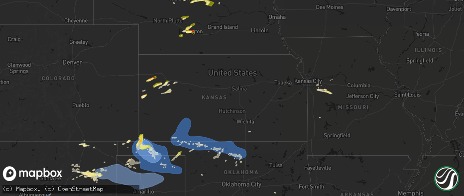
Hail
Wind
388
Estimated number of impacted properties by a 1.00" hail or larger62
Estimated number of impacted properties by a 1.75" hail or larger0
Estimated number of impacted properties by a 2.50" hail or largerStorm reports in Kansas
Kansas
| Date | Description |
|---|---|
| 06/12/202612:45 AM CDT | A local report indicates 61 MPH wind near 3 W Bloom |
| 06/12/202612:25 AM CDT | A local report indicates 64 MPH wind near 3 ENE Dodge City |
| 06/12/202612:00 AM CDT | A local report indicates 58 MPH wind near 3 ENE Dodge City |
| 06/11/202611:59 PM CDT | Asos station kddc dodge city regional airport. |
| 06/11/20269:05 PM CDT | Social media report of dime sized hail with a few golf ball sized as well. |
| 06/11/20268:22 PM CDT | A local report indicates 1.00 inch wind near 10 WSW Richfield |
| 06/11/20268:14 PM CDT | A local report indicates 1.00 inch wind near Elkhart |
| 06/11/20268:07 PM CDT | A local report indicates 1.75 inch wind near Elkhart |
All States Impacted by Hail Map on June 12, 2026
Cities Impacted by Hail Map on June 12, 2026
- Kenton, TN
- Trimble, TN
- Friendship, TN
- Booker, TX
- Perryton, TX
- Follett, TX
- Laverne, OK
- Balko, OK
- Lexington, TN
- Brighton, TN
- Covington, TN
- May, OK
- Buffalo, OK
- Lamar, OK
- Mcalester, OK
- Green Pond, SC
- Yemassee, SC
- Nellis, WV
- Ridgeview, WV
- Costa, WV
- Peytona, WV
- Ashford, WV
- Winifrede, WV
- Cabin Creek, WV
- Hernshaw, WV
- Julian, WV
- Comfort, WV
- Round O, SC
- Harrogate, TN
- Eskdale, WV
- Ewing, VA
- Mount Nebo, WV
- Summersville, WV
- Tazewell, TN
- Cloudcroft, NM
- Madison, VA
- Banco, VA
- Reva, VA
- Ludowici, GA
- Summerville, SC
- Ladson, SC
- Mount Hope, WV
- Haywood, VA
- Van Horn, TX
- Fairfield, MT
- Renick, WV
- Arcadia, FL
- Fredericksburg, VA
- Scarbro, WV
- Meadow Bridge, WV
- Grassy Meadows, WV
- Richardsville, VA
- Huger, SC
- Frenchtown, NJ
- Flemington, NJ
- Pittstown, NJ
- Haymarket, VA
- Broad Run, VA
- Spring Dale, WV
- Fort Stockton, TX
- Fort Shaw, MT
- Swiss, WV
- Belva, WV
- The Plains, VA
- Jewell Ridge, VA
- Raysal, WV
- Spotsylvania, VA
- Alpine, TX
- Ronceverte, WV
- Lewisburg, WV
- Caldwell, WV
- Alderson, WV
- Poplar Grove, AR
- Gainesville, VA
- Catharpin, VA
- Moro, AR
- Weed, NM
- Deerfield, VA
- Manassas, VA
- Centreville, VA
- Chantilly, VA
- Vaughn, MT
- Middleburg, VA
- Stanardsville, VA
- West Cornwall, CT
- Sharon, CT
- Locust Grove, VA
- Stafford, VA
- Sun River, MT
- Power, MT
- Great Falls, MT
- Punta Gorda, FL
- Sebring, FL
- Welch, WV
- Hillsboro, WV
- Sacramento, NM
- Zolfo Springs, FL
- Marvell, AR
- Nassau, NY
- Old Chatham, NY
- Malden Bridge, NY
- Nanjemoy, MD
- West Augusta, VA
- Lake Wales, FL
- Dundee, FL
- Culpeper, VA
- Hood, VA
- Oakpark, VA
- Brightwood, VA
- Pratts, VA
- Aroda, VA
- Fayette, AL
- Brainard, NY
- Greenville, VA
- Stuarts Draft, VA
- Milford, VA
- Hustle, VA
- Elkton, VA
- Dyke, VA
- Northport, AL
- Orange, VA
- Radiant, VA
- Locust Dale, VA
- Haines City, FL
- Kissimmee, FL
- Manahawkin, NJ
- Staffordsville, VA
- Ruckersville, VA
- Barboursville, VA
- Rochelle, VA
- Marathon, TX
- Alamogordo, NM
- Brooklet, GA
- Champlain, VA
- South Kent, CT
- Kent, CT
- Wingdale, NY
- Charlottesville, VA
- Jesup, GA
- Lakeville, CT
- Bedford, VA
- Raton, NM
- Somerset, VA
- Trinidad, CO
- Statesboro, GA
- Thaxton, VA
- North Garden, VA
- Belt, MT
- Upperville, VA
- Hiwassee, VA
- Draper, VA
- Tappahannock, VA
- Salisbury, CT
- Falls Village, CT
- Keswick, VA
- Pulaski, VA
- Marshall, VA
- Franklin Lakes, NJ
- Oakland, NJ
- Maywood, NJ
- Lodi, NJ
- Paramus, NJ
- Saddle Brook, NJ
- Fair Lawn, NJ
- Rochelle Park, NJ
- Gaylordsville, CT
- New Milford, CT
- Woodbury, CT
- Bethlehem, CT
- Nutley, NJ
- Glen Ridge, NJ
- Bloomfield, NJ
- Montclair, NJ
- Horse Shoe, NC
- Mills River, NC
- Harmony, ME
- Lowry, VA
- Goode, VA
- Montpelier, VA
- Thomaston, CT
- Watertown, CT
- Madison Heights, VA
- Amherst, VA
- Cottondale, AL
- Tuscaloosa, AL
- Forest, VA
- Ashland, VA
- Secaucus, NJ
- East Rutherford, NJ
- North Bergen, NJ
- Lyndhurst, NJ
- West New York, NJ
- Weehawken, NJ
- Carlstadt, NJ
- Union City, NJ
- Clifton, NJ
- Moneta, VA
- Vinton, VA
- Herndon, VA
- Leesburg, VA
- Aldie, VA
- Sterling, VA
- Reston, VA
- Ashburn, VA
- Bluemont, VA
- Oakton, VA
- Fairfax, VA
- Round Hill, VA
- Hendersonville, NC
- Middlebury, CT
- Waterbury, CT
- Oakville, CT
- Ocate, NM
- Lynchburg, VA
- Vienna, VA
- Springfield, VA
- Falls Church, VA
- Annandale, VA
- Alexandria, VA
- Arlington, VA
- Mill Spring, NC
- Sylvania, GA
- Lancaster, VA
- Heathsville, VA
- Concord, VA
- Baxley, GA
- Wagon Mound, NM
- Glen Allen, VA
- Rockville, VA
- La Plata, MD
- Fort Washington, MD
- Brandywine, MD
- Clinton, MD
- Accokeek, MD
- Waldorf, MD
- White Plains, MD
- Pomfret, MD
- Stanford, MT
- Geyser, MT
- Burgess, VA
- Capulin, NM
- Flat Rock, NC
- Saluda, NC
- Etowah, NC
- Pisgah Forest, NC
- Marietta, SC
- Zirconia, NC
- Des Moines, NM
- Annapolis, MD
- Crownsville, MD
- Arnold, MD
- Solano, NM
- Grenville, NM
- Boise City, OK
- Ruston, LA
- Amelia Court House, VA
- Ford, VA
- Roy, NM
- Severna Park, MD
- Edgewater, MD
- Davidsonville, MD
- Grambling, LA
- Campo, CO
- Temperanceville, VA
- Stevensville, MD
- Gambrills, MD
- Elkhart, KS
- Chester, MD
- Clayton, NM
- Keyes, OK
- Wallops Island, VA
- Horntown, VA
- Oak Hall, VA
- Atlantic, VA
- New Church, VA
- Tribune, KS
- Goodwell, OK
- Texhoma, OK
- Richfield, KS
- Walsh, CO
- Dalhart, TX
- Moriarty, NM
- Roxobel, NC
- Scotland Neck, NC
- Rolla, KS
- Guymon, OK
- Stratford, TX
- Mosquero, NM
- Aulander, NC
- Kelford, NC
- Edgewood, NM
- Hooker, OK
- Gruver, TX
- Texhoma, TX
- Amistad, NM
- Sedan, NM
- Texline, TX
- Tijeras, NM
- Stanley, NM
- Rich Square, NC
- Colerain, NC
- Ahoskie, NC
- Weskan, KS
- Sharon Springs, KS
- Spearman, TX
- Hardesty, OK
- Conchas Dam, NM
- South Mills, NC
- Nara Visa, NM
- Turpin, OK
- Sunray, TX
- Beaver, OK
- Moyock, NC
- Stinnett, TX
- Morse, TX
- Hartley, TX
- Logan, NM
- Channing, TX
- Las Vegas, NM
- Maple, NC
- Currituck, NC
- Trementina, NM
- Shawboro, NC
- Barco, NC
- Wallace, KS
- Winona, KS
- Edson, KS
- Coinjock, NC
- Plymouth, NC
- Vega, TX
- Adrian, TX
- Plains, KS
- Colby, KS
- Monument, KS
- Levant, KS
- Vaughn, NM
- Nags Head, NC
- Manteo, NC
- Manns Harbor, NC
- Kitty Hawk, NC
- Miami, TX
- Dumas, TX
- Gate, OK
- Meade, KS
- Oakley, KS
- Kill Devil Hills, NC
- Scott City, KS
- Forgan, OK
- Grinnell, KS
- Masterson, TX
- Amarillo, TX
- Rosston, OK
- Healy, KS
- Canadian, TX
- Wanchese, NC
- Dodge City, KS
- Protection, KS
- Fowler, KS
- Ashland, KS
- Coldwater, KS
- Spearville, KS
- Ensign, KS
- Englewood, KS
- Minneola, KS
- Ford, KS
- Wright, KS
- Higgins, TX
- Fritch, TX
- Panhandle, TX
- Borger, TX
- Skellytown, TX
- Grainfield, KS
- Gove, KS
- Park, KS
- Freedom, OK
- Mooreland, OK
- Lake City, KS
- Alva, OK
- Wilmore, KS
- Pampa, TX
- White Deer, TX
- Waynoka, OK
- Hardtner, KS
- Tucumcari, NM
- Burlington, OK
- Cherokee, OK
- Chester, OK
- Dacoma, OK
- Leedey, OK
- Butler, OK
- Aline, OK
- Fairview, OK
- Cleo Springs, OK
- Carmen, OK
- Helena, OK
- Jet, OK
- Amorita, OK
- Goltry, OK
- Wakita, OK
- Pond Creek, OK
- Manchester, OK
- Nash, OK
- Medford, OK
- Ringwood, OK
- Lees Summit, MO
- Grain Valley, MO
- Carrier, OK
- Enid, OK
- Kremlin, OK
- Meno, OK
- Ames, OK
- Bates City, MO
- Oak Grove, MO
- Garber, OK
- Kingsville, MO
- Strasburg, MO
- Pleasant Hill, MO
- Hunter, OK
- Wellington, KS
- Belle Plaine, KS
- Oxford, KS
- Udall, KS
- Douglas, OK
- Holden, MO
- Waukomis, OK
- Marshall, OK
- Fairmont, OK
- Anselmo, NE
- Covington, OK
- Billings, OK
- Hennessey, OK
- Burwell, NE


