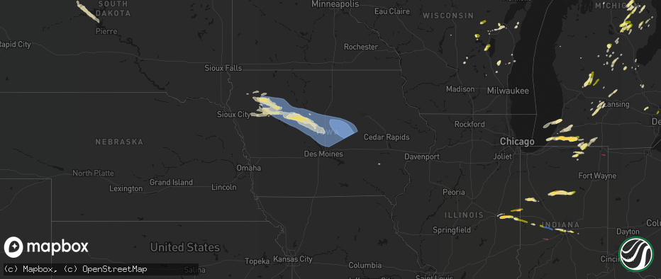
Hail Map in Iowa on June 16, 2026
The weather event in Iowa on June 16, 2026 includes Hail, Wind, and Tornado maps. 13 states and 578 cities were impacted and suffered possible damage. The total estimated number of properties impacted is 0.
Hail
Wind
Tornado
0
Estimated number of impacted properties by a 1.00" hail or larger0
Estimated number of impacted properties by a 1.75" hail or larger0
Estimated number of impacted properties by a 2.50" hail or largerStorm reports in Iowa
Iowa
| Date | Description |
|---|---|
| 06/16/20266:57 AM CDT | A local report indicates 66 MPH wind near Cedar Rapids Municipali |
| 06/16/20266:52 AM CDT | Marion county ema reported peeled metal roofs... Damage to trees and a flipped trailer. Delayed report. |
| 06/16/20266:52 AM CDT | A local report indicates 75 MPH wind near 1 ESE Walford |
| 06/16/20266:38 AM CDT | A local report indicates 74 MPH wind near 2 SE Van Horne |
| 06/16/20266:38 AM CDT | A local report indicates 65 MPH wind near Blairstown |
| 06/16/20266:33 AM CDT | A local report indicates 63 MPH wind near 3 SW Koszta |
| 06/16/20266:22 AM CDT | Story and hardin co ema reported 2 miles of large power poles snapped along the story/hardin county line. Time estimated from radar. Delayed report. |
| 06/16/20266:15 AM CDT | Delayed report. Social media picture of large branches down in tama. |
| 06/16/20266:11 AM CDT | Pws gust. |
| 06/16/20265:57 AM CDT | Multiple trees uprooted. |
| 06/16/20265:50 AM CDT | Delayed report. Machine shed destroyed and significant tree damage. Time estimated by radar. |
| 06/16/20265:47 AM CDT | Large tree snapped near its base in conrad. Time estimated via radar. |
| 06/16/20265:47 AM CDT | A local report indicates 60 MPH wind near Conrad |
| 06/16/20265:46 AM CDT | Trees blocking roads in conrad. Time estimated via radar. |
| 06/16/20265:45 AM CDT | A local report indicates 94 MPH wind near 4 E Albion |
| 06/16/20265:40 AM CDT | Delayed report. Estimated peak wind gust in nevada. |
| 06/16/20265:35 AM CDT | Delayed report. Large branches down and corn stalks snapped near ground level. |
| 06/16/20265:29 AM CDT | Pws gust. |
| 06/16/20265:28 AM CDT | Pws gust. |
| 06/16/20265:22 AM CDT | Pws gust. |
| 06/16/20265:02 AM CDT | Pws gust. |
| 06/16/20264:55 AM CDT | A local report indicates 76 MPH wind near 3 SW Webster City |
| 06/16/20264:49 AM CDT | A local report indicates 62 MPH wind near 3 SW Webster City |
| 06/16/20264:45 AM CDT | Pws gust. |
| 06/16/20264:30 AM CDT | Two semis blown over on us-20. |
| 06/16/20264:25 AM CDT | Pws gust. |
| 06/16/20263:52 AM CDT | Awos station kslb storm lake airport. |
| 06/16/20263:32 AM CDT | Mesonet station rsli4 storm lake. |
All States Impacted by Hail Map on June 16, 2026
Cities Impacted by Hail Map on June 16, 2026
- Green Valley, IL
- Pekin, IL
- Tremont, IL
- Curran, MI
- Hubbard Lake, MI
- Lachine, MI
- Wisconsin Rapids, WI
- Milford, MI
- Roscommon, MI
- Saint Helen, MI
- Bear Creek, WI
- Pardeeville, WI
- West Branch, MI
- Luzerne, MI
- Clintonville, WI
- Rose City, MI
- Dalton, WI
- Shiocton, WI
- Gladwin, MI
- Weyauwega, WI
- Highland, MI
- Markesan, WI
- Fremont, WI
- Montello, WI
- Brighton, MI
- Mio, MI
- Fairview, MI
- Comins, MI
- Lewiston, MI
- Oshkosh, WI
- Pickett, WI
- Casco, WI
- Hillman, MI
- West Bend, WI
- Sheboygan, WI
- Algoma, WI
- Iron Ridge, WI
- Hortonville, WI
- Hale, MI
- Atlanta, MI
- Glennie, MI
- South Branch, MI
- Sheboygan Falls, WI
- Oostburg, WI
- Scottville, MI
- Appleton, WI
- Greenville, WI
- Kewaunee, WI
- Campbellsport, WI
- Kaukauna, WI
- Oneida, WI
- Luxemburg, WI
- Lupton, MI
- Clare, MI
- Plymouth, WI
- Cascade, WI
- Saint Cloud, WI
- De Pere, WI
- Green Bay, WI
- Mikado, MI
- Millersburg, MI
- Hawks, MI
- Onaway, MI
- Rogers City, MI
- Adell, WI
- Kiel, WI
- Valders, WI
- Merrill, MI
- Waldo, WI
- Lincoln, MI
- Harrisville, MI
- Midland, MI
- Freeland, MI
- Hemlock, MI
- Oscoda, MI
- Rockford, MI
- Kawkawlin, MI
- Belmont, MI
- Port Austin, MI
- Dowling, MI
- Delton, MI
- Gowen, MI
- Cedar Springs, MI
- Hastings, MI
- Linwood, MI
- Sand Lake, MI
- Battle Creek, MI
- Westphalia, MI
- Greenville, MI
- Eagle, MI
- Portland, MI
- Lakeview, MI
- Shepherd, MI
- Vestaburg, MI
- Mount Pleasant, MI
- Edmore, MI
- Six Lakes, MI
- Remus, MI
- Blanchard, MI
- Pierson, MI
- Stanton, MI
- Trufant, MI
- Coral, MI
- Nashville, MI
- Bellevue, MI
- Howard City, MI
- Fowler, MI
- Saint Johns, MI
- Saint Joseph, IL
- Urbana, IL
- Ogden, IL
- Fithian, IL
- Vermontville, MI
- Muncie, IL
- Oakwood, IL
- Fairmount, IL
- Oxford, IN
- Boswell, IN
- Armstrong, IL
- Catlin, IL
- Homer, IL
- Westville, IL
- Danville, IL
- Camden, IN
- Delphi, IN
- Sopchoppy, FL
- Tallahassee, FL
- Crawfordville, FL
- Georgetown, IL
- Saginaw, MI
- Bay City, MI
- Templeton, IN
- Pine Village, IN
- Otterbein, IN
- Woodland, MI
- Perrysville, IN
- West Lafayette, IN
- Logansport, IN
- Walton, IN
- Galveston, IN
- Hubbardston, MI
- Muir, MI
- Fenwick, MI
- Sunfield, MI
- Champaign, IL
- Mulliken, MI
- Barryton, MI
- Sears, MI
- Lake, MI
- Charlotte, MI
- Grissom Arb, IN
- Peru, IN
- Onward, IN
- Beaverton, MI
- Mount Morris, MI
- Bismarck, IL
- West Lebanon, IN
- Harrison, MI
- Columbus, ND
- Coleman, MI
- Sawyer, MI
- Farwell, MI
- Clio, MI
- Flint, MI
- Bunker Hill, IN
- Miami, IN
- Lignite, ND
- Bowbells, ND
- Baroda, MI
- Bridgman, MI
- Buchanan, MI
- Amboy, IN
- Converse, IN
- Wabash, IN
- Berrien Springs, MI
- Kenmare, ND
- Stanley, ND
- Powers Lake, ND
- South Haven, MI
- Covert, MI
- Eau Claire, MI
- Benton Harbor, MI
- Ashland, KS
- Berrien Center, MI
- Niles, MI
- Dowagiac, MI
- La Fontaine, IN
- Donnybrook, ND
- Palermo, ND
- Loring, MT
- Marshall, IN
- Waveland, IN
- Decatur, MI
- Hartford, MI
- Bloomingdale, IN
- Franklin, MI
- Southfield, MI
- Paris, MI
- Watervliet, MI
- Bloomfield Hills, MI
- Birmingham, MI
- Cassopolis, MI
- Vandalia, MI
- Paw Paw, MI
- Lawrence, MI
- Saint Mary, MO
- Sainte Genevieve, MO
- Berthold, ND
- Marcellus, MI
- Jones, MI
- Gate, OK
- Perryville, MO
- Tonto Basin, AZ
- Cutler, IL
- Pinckneyville, IL
- Viola, KS
- Clearwater, KS
- Tamaroa, IL
- Du Quoin, IL
- Three Rivers, MI
- Cayuga, IN
- Kingman, IN
- Covington, IN
- Ladoga, IN
- Roachdale, IN
- North Salem, IN
- Rosston, OK
- Chinook, MT
- Plaza, ND
- Jetmore, KS
- Spearville, KS
- Wright, KS
- New Paris, IN
- Goshen, IN
- Millersburg, IN
- Howe, IN
- Shipshewana, IN
- Middlebury, IN
- White Pigeon, MI
- Sturgis, MI
- Danville, IN
- Benton, IL
- Scheller, IL
- Waltonville, IL
- Bonnie, IL
- Sesser, IL
- Syracuse, IN
- Minot, ND
- Peck, KS
- Larned, KS
- Garfield, KS
- Constantine, MI
- Glenburn, ND
- Bristol, IN
- Whittington, IL
- Ina, IL
- Ewing, IL
- Centreville, MI
- Sodus, MI
- Belle Plaine, KS
- Brownsburg, IN
- Indianapolis, IN
- Avon, IN
- Belpre, KS
- Ryder, ND
- Des Lacs, ND
- Bronson, MI
- Burr Oak, MI
- Laverne, OK
- Topeka, IN
- Belle Rive, IL
- Ford, KS
- Harlem, MT
- Sherwood, MI
- Coldwater, MI
- Elmira, MI
- Sheridan, MI
- Sidney, MI
- Shattuck, OK
- Macksville, KS
- Freedom, OK
- New Palestine, IN
- Greenfield, IN
- Lansford, ND
- Minot Afb, ND
- Surrey, ND
- Norwich, ND
- Velva, ND
- Granville, ND
- Voltaire, ND
- Ruso, ND
- Butte, ND
- Drake, ND
- Balfour, ND
- Mcclusky, ND
- Denhoff, ND
- Goodrich, ND
- Anamoose, ND
- Bucklin, KS
- Karlsruhe, ND
- Byers, KS
- Greencastle, IN
- Cloverdale, IN
- Mooreland, OK
- Pleasant Lake, IN
- Hamilton, IN
- Pratt, KS
- Scammon, KS
- Cherokee, KS
- Columbus, KS
- Sells, AZ
- Haviland, KS
- Morristown, IN
- Weir, KS
- Collison, IL
- Potomac, IL
- Alvin, IL
- Tucson, AZ
- Waynoka, OK
- Mullinville, KS
- Minneola, KS
- Sawyer, KS
- Coats, KS
- Sun City, KS
- Medicine Lodge, KS
- Protection, KS
- Lake City, KS
- Olpe, KS
- Madison, KS
- Hartford, KS
- Emporia, KS
- Dupree, SD
- Eagle Butte, SD
- Winfield, KS
- Rock, KS
- Burden, KS
- Gridley, KS
- Virgil, KS
- Yates Center, KS
- Cambridge, KS
- Fort Pierre, SD
- Dexter, KS
- Cedar Vale, KS
- Chanute, KS
- Buffalo, KS
- Benedict, KS
- Altoona, KS
- Thayer, KS
- Epping, ND
- Galesburg, KS
- Ray, ND
- Parsons, KS
- Oswego, KS
- Lake Odessa, MI
- Freeport, MI
- Marcus, IA
- Larrabee, IA
- Cleghorn, IA
- Meriden, IA
- Cherokee, IA
- Aurelia, IA
- Alta, IA
- Peterson, IA
- Linn Grove, IA
- Alton, IA
- Storm Lake, IA
- Rembrandt, IA
- Newell, IA
- Truesdale, IA
- Schaller, IA
- Holstein, IA
- Quimby, IA
- Galva, IA
- Paullina, IA
- Granville, IA
- Early, IA
- Nemaha, IA
- Sac City, IA
- Sutherland, IA
- Pomeroy, IA
- Manson, IA
- Williams, IA
- Lytton, IA
- Rockwell City, IA
- Jolley, IA
- Fonda, IA
- Moorland, IA
- Somers, IA
- Gowrie, IA
- Callender, IA
- Washta, IA
- Farnhamville, IA
- Knierim, IA
- Lohrville, IA
- Fort Dodge, IA
- Dayton, IA
- Paton, IA
- Lehigh, IA
- Burnside, IA
- Harcourt, IA
- Otho, IA
- Barnum, IA
- Stratford, IA
- Pierson, IA
- Correctionville, IA
- Cushing, IA
- Boone, IA
- Stanhope, IA
- Pilot Mound, IA
- Boxholm, IA
- Ames, IA
- Gilbert, IA
- Story City, IA
- Ida Grove, IA
- Duncombe, IA
- Keota, IA
- Albert City, IA
- Palmer, IA
- Marathon, IA
- Laurens, IA
- Pocahontas, IA
- Sioux Rapids, IA
- Lake City, IA
- Churdan, IA
- Auburn, IA
- Varina, IA
- Whitten, IA
- Traer, IA
- Clutier, IA
- Hubbard, IA
- Badger, IA
- Melbourne, IA
- Madrid, IA
- Slater, IA
- Huxley, IA
- Randall, IA
- Cambridge, IA
- Kamrar, IA
- Colo, IA
- New Providence, IA
- Webster City, IA
- Ellsworth, IA
- Jefferson, IA
- Ogden, IA
- Saint Anthony, IA
- Clare, IA
- Albion, IA
- Alden, IA
- Marshalltown, IA
- Dana, IA
- Clemons, IA
- Zearing, IA
- Woodward, IA
- Eldora, IA
- Luther, IA
- Kelley, IA
- Conrad, IA
- Vincent, IA
- Grand Junction, IA
- Garwin, IA
- Maxwell, IA
- Collins, IA
- Beaman, IA
- State Center, IA
- Sheldahl, IA
- Humboldt, IA
- Garden City, IA
- Radcliffe, IA
- Liscomb, IA
- Nevada, IA
- Polk City, IA
- Toledo, IA
- Roland, IA
- Blairsburg, IA
- Iowa Falls, IA
- Woolstock, IA
- Beaver, IA
- Jewell, IA
- McCallsburg, IA
- Gladbrook, IA
- Union, IA
- Gilmore City, IA
- Grundy Center, IA
- Steamboat Rock, IA
- Haverhill, IA
- Rhodes, IA
- Ankeny, IA
- Bondurant, IA
- Alleman, IA
- Elkhart, IA
- Montour, IA
- Baxter, IA
- Mingo, IA
- Washington, IA
- West Chester, IA
- Tama, IA
- Colfax, IA
- Newton, IA
- Chelsea, IA
- Ira, IA
- Le Grand, IA
- Brooklyn, IA
- Belle Plaine, IA
- Hartwick, IA
- Monroe, IA
- Kellogg, IA
- Sully, IA
- Lynnville, IA
- Killduff, IA
- Ferguson, IA
- Gilman, IA
- Laurel, IA
- Grinnell, IA
- Dysart, IA
- Reinbeck, IA
- Lincoln, IA
- Malcom, IA
- Reasnor, IA
- Pella, IA
- Otley, IA
- Searsboro, IA
- Vinton, IA
- Montezuma, IA
- Vining, IA
- Keystone, IA
- New Sharon, IA
- Elberon, IA
- Van Horne, IA
- Garrison, IA
- Luzerne, IA
- Leighton, IA
- Marengo, IA
- Blairstown, IA
- Barnes City, IA
- Deep River, IA
- Guernsey, IA
- Victor, IA
- Oskaloosa, IA
- Williamsburg, IA
- Parnell, IA
- Sigourney, IA
- Harper, IA
- Conroy, IA
- Gibson, IA
- What Cheer, IA
- Watkins, IA
- South English, IA
- Millersburg, IA
- Webster, IA
- Newhall, IA
- Ladora, IA
- North English, IA
- Keswick, IA
- Rose Hill, IA
- Wellman, IA
- South Amana, IA
- Shellsburg, IA
- Solon, IA
- Homestead, IA
- Ely, IA
- Oxford, IA
- Walford, IA
- Middle Amana, IA
- North Liberty, IA
- Lisbon, IA
- Cedar Rapids, IA
- Kalona, IA
- Amana, IA
- Mount Vernon, IA
- Fairfax, IA
- Coralville, IA
- Tiffin, IA
- Iowa City, IA
- Marion, IA
- Palo, IA
- Swisher, IA
- Atkins, IA
- Norway, IA


