Hail Map in Atwood, KS on June 20, 2026
The weather event in Atwood, KS on June 20, 2026 includes Hail and Wind maps. 12 states and 160 cities were impacted and suffered possible damage. The total estimated number of properties impacted is 189.
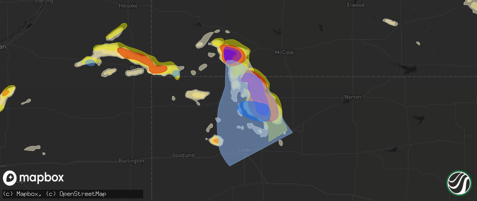
Hail
Wind
189
Estimated number of impacted properties by a 1.00" hail or larger185
Estimated number of impacted properties by a 1.75" hail or larger180
Estimated number of impacted properties by a 2.50" hail or largerStorm reports in Atwood, KS
Atwood, KS
| Date | Description |
|---|---|
| 06/20/20265:29 PM CDT | Nssl measured 89 mph wind gust 3 miles south of atwood. |
| 06/20/20265:19 PM CDT | Tds observed on radar. |
| 06/20/20265:10 PM CDT | Social media report of a photo of a tornado via x. |
| 06/20/20265:07 PM CDT | Multiple reports from chasers of a tornado crossing highway 36 near atwood. |
| 06/20/20265:06 PM CDT | Multiple chaser reports and video on livestream of power poles being knocked down. |
| 06/20/20264:17 PM CDT | Report from mping: ping pong ball |
All States Impacted by Hail Map on June 20, 2026
All Cities Impacted by Hail Map on June 20, 2026
- Loomis, NE
- Bertrand, NE
- Holdrege, NE
- Wilcox, NE
- Dunning, NE
- Broken Bow, NE
- Oconto, NE
- Mason City, NE
- Miller, NE
- Sumner, NE
- Anselmo, NE
- Pleasanton, NE
- Amherst, NE
- Elm Creek, NE
- Merna, NE
- Riverdale, NE
- Kearney, NE
- Callaway, NE
- Ansley, NE
- Gibbon, NE
- Shelton, NE
- Kenesaw, NE
- Wood River, NE
- Juniata, NE
- Hazard, NE
- Litchfield, NE
- Roseland, NE
- Hastings, NE
- Ayr, NE
- Glenvil, NE
- Halsey, NE
- Fairfield, NE
- Arnold, NE
- Ravenna, NE
- Stapleton, NE
- Valentine, NE
- Clay Center, NE
- Deweese, NE
- Mauk, GA
- Butler, GA
- Junction City, GA
- Edgar, NE
- Birmingham, AL
- Leeds, AL
- Brewster, NE
- Davenport, NE
- Doniphan, NE
- Thedford, NE
- Orlando, FL
- Trumbull, NE
- Venus, FL
- Elsmere, NE
- Sterrett, AL
- Vandiver, AL
- Harvard, NE
- Inland, NE
- Johnstown, NE
- Ong, NE
- Ainsworth, NE
- Saronville, NE
- Shickley, NE
- Sutton, NE
- Carleton, NE
- Marshallville, GA
- Bruning, NE
- Belvidere, NE
- Long Pine, NE
- Alexandria, NE
- Lake Placid, FL
- Montezuma, GA
- Boyers, PA
- Harrisville, PA
- Slippery Rock, PA
- Kilgore, NE
- Sebring, FL
- Crookston, NE
- Fairbury, NE
- Grand Island, NE
- Byromville, GA
- Unadilla, GA
- Lorida, FL
- Benkelman, NE
- Fort Pierce, FL
- Palisade, NE
- Wauneta, NE
- Stratton, NE
- Yuma, CO
- Purdum, NE
- Alma, GA
- Deer Trail, CO
- Eckley, CO
- Pineview, GA
- Pinehurst, GA
- Hawkinsville, GA
- Douglas, GA
- Woodrow, CO
- Wray, CO
- Max, NE
- Nicholls, GA
- Jesup, GA
- Snowville, UT
- Palm City, FL
- Hortense, GA
- Trenton, NE
- Lindon, CO
- Atwood, KS
- Hanna, WY
- Otis, CO
- Stuart, FL
- Ludell, KS
- Cheyenne, WY
- Kim, CO
- Taylor, NE
- Herndon, KS
- Lake City, FL
- Geneva, NE
- Strang, NE
- Jupiter, FL
- West Palm Beach, FL
- Haigler, NE
- Lumpkin, GA
- Laurel Hill, FL
- Sterling, MI
- Norris, SD
- Palm Beach Gardens, FL
- Genoa, CO
- Ohiowa, NE
- Culbertson, NE
- Medicine Bow, WY
- Winner, SD
- Lagrange, WY
- Burwell, NE
- Tobias, NE
- Standish, MI
- Arriba, CO
- Omer, MI
- Bennett, CO
- Holyoke, CO
- Loxahatchee, FL
- Wellington, FL
- Grouse Creek, UT
- Lamar, CO
- Sargent, NE
- Pompano Beach, FL
- Daykin, NE
- Malad City, ID
- Parks, NE
- Saint Francis, KS
- Las Animas, CO
- Plymouth, NE
- Jansen, NE
- Elyria, NE
- Preston, ID
- Lewiston, UT
- Comstock, NE
- McDonald, KS
- Diller, NE
- Western, NE
- Ochopee, FL
- Pritchett, CO


