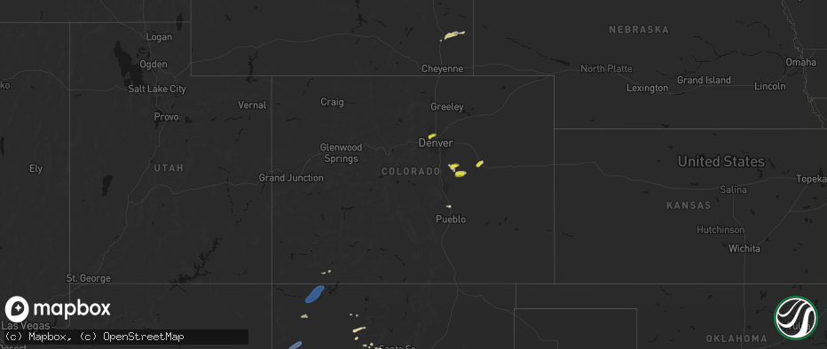
Hail Map in Colorado on June 26, 2026
The weather event in Colorado on June 26, 2026 includes Hail, Wind, and Tornado maps. 21 states and 389 cities were impacted and suffered possible damage. The total estimated number of properties impacted is 46,997.
Hail
Wind
Tornado
46,997
Estimated number of impacted properties by a 1.00" hail or larger318
Estimated number of impacted properties by a 1.75" hail or larger0
Estimated number of impacted properties by a 2.50" hail or largerStorm reports in Colorado
Colorado
| Date | Description |
|---|---|
| 06/26/20265:27 PM CDT | Asos station klic limon. |
| 06/26/20263:12 PM CDT | A local report indicates 1.00 inch wind near 2 ESE Broomfield |
| 06/26/20263:05 PM CDT | A local report indicates 1.00 inch wind near 1 SSW Westminster |
| 06/26/20263:03 PM CDT | Report from mping: quarter |
| 06/25/202610:15 PM CDT | Awos station k20v kremmling awos. |
| 06/25/20269:19 PM CDT | Report via textline of pictured ping pong ball sized hail. |
| 06/25/20268:46 PM CDT | Cdot mesonet 068 site reported a 68 mph gust. |
| 06/25/20268:43 PM CDT | A local report indicates 58 MPH wind near 4 WSW Lamar |
| 06/25/20268:36 PM CDT | Location approx. Possible tornado spotted north west of cheyenne wells on county road 38 keeps going down and going back up with lots of rotation in the clouds per trai |
| 06/25/20268:17 PM CDT | Damage to car windshield. |
| 06/25/20267:52 PM CDT | Brief tornado was observed to the ne of las animas. Video from a storm chaser shows clear ground circulation... With debris as well. Another spotter looking due west fr |
| 06/25/20267:23 PM CDT | Davis weatherlink: sk farm site reported a 60 mph gust. |
| 06/25/20267:19 PM CDT | Location estimated. Report via twitter. Brief cone tornado about 10 minutes ago just west of kit carson... Colorado. Only was down for about 20 seconds. |
All States Impacted by Hail Map on June 26, 2026
Cities Impacted by Hail Map on June 26, 2026
- Putnam Station, NY
- Orwell, VT
- Fair Haven, VT
- Brandon, VT
- Bomoseen, VT
- Castleton, VT
- Florence, VT
- West Rutland, VT
- Ganado, AZ
- Proctor, VT
- Campton, KY
- Farmington, NM
- Ezel, KY
- Hazel Green, KY
- Arvada, CO
- Broomfield, CO
- Los Lunas, NM
- Elizabeth, CO
- Gallup, NM
- Golden, CO
- Kiowa, CO
- Denver, CO
- Westminster, CO
- Elbert, CO
- Grants, NM
- Bluewater, NM
- Franktown, CO
- Chaffee, MO
- Belen, NM
- Gamerco, NM
- Palm Coast, FL
- Scott City, MO
- Charleston, MO
- Benton, MO
- Fountain, CO
- Fort Myers, FL
- Tohatchi, NM
- Cairo, IL
- Miller City, IL
- Pueblo, CO
- Ashton, ID
- Cornish, NH
- Windsor, VT
- Thebes, IL
- Chugwater, WY
- Bertrand, MO
- Sikeston, MO
- Lehigh Acres, FL
- Bunnell, FL
- Newport, NH
- Cubero, NM
- Wesley Chapel, FL
- Sunapee, NH
- New London, NH
- Newbury, NH
- Bradford, NH
- Lindrith, NM
- Jemez Springs, NM
- Lutz, FL
- Brownsville, VT
- Hawk Springs, WY
- Yoder, WY
- Reading, VT
- Bayfield, CO
- Agate, CO
- South Sutton, NH
- North Sutton, NH
- Warner, NH
- Peyton, CO
- Calhan, CO
- Kingstree, SC
- Thoreau, NM
- Ponderosa, NM
- Land O'Lakes, FL
- Bradley, FL
- Bowling Green, FL
- Mulberry, FL
- Waycross, GA
- Aztec, NM
- Bloomfield, NM
- Ramah, CO
- Fort Davis, TX
- Andrews, SC
- Bartow, FL
- Arcadia, FL
- Durango, CO
- Flora Vista, NM
- Bosque, NM
- Magdalena, NM
- San Acacia, NM
- La Joya, NM
- Cuba, NM
- La Jara, NM
- Counselor, NM
- Miami, TX
- Varney, KY
- Sidney, KY
- Pikeville, KY
- Carl Junction, MO
- Mooreland, OK
- Chester, OK
- Gillette, WY
- Myakka City, FL
- Pena Blanca, NM
- Los Alamos, NM
- Bow, NH
- Contoocook, NH
- Concord, NH
- Ringwood, OK
- Canada, KY
- Enid, OK
- Lusk, WY
- Folsom, NM
- Grenville, NM
- Lyman, NE
- Ona, FL
- Manville, WY
- Avondale, CO
- Gering, NE
- Canadian, TX
- Fairmont, OK
- Kremlin, OK
- Conway, MO
- Wann, OK
- Shawnee, WY
- Billings, OK
- Boone, CO
- Ava, MO
- Limon, CO
- Genoa, CO
- Garber, OK
- Woodward, OK
- Scottsbluff, NE
- Mitchell, NE
- Coffeyville, KS
- S Coffeyville, OK
- Greeley, CO
- Eaton, CO
- Lucerne, CO
- Buffalo, OK
- Fort Supply, OK
- Denton, MT
- Hilger, MT
- Waynoka, OK
- Perry, OK
- Hunter, OK
- Pond Creek, OK
- Kit Carson, CO
- Hugo, CO
- Seibert, CO
- Flagler, CO
- Fowler, CO
- Winifred, MT
- Lucien, OK
- Covington, OK
- Douglas, OK
- Watonga, OK
- Harrison, NE
- Alva, OK
- Karval, CO
- Lamont, OK
- Kenton, OK
- Candia, NH
- Raymond, NH
- Clayton, NM
- Suncook, NH
- Tonkawa, OK
- Gill, CO
- Londonderry, NH
- Seiling, OK
- Hitchcock, OK
- Okeene, OK
- Mobeetie, TX
- Wheeler, TX
- Briscoe, TX
- Vona, CO
- Stratton, CO
- Galeton, CO
- Briggsdale, CO
- Newcastle, WY
- Upton, WY
- Minatare, NE
- Ponca City, OK
- Lenapah, OK
- Pritchett, CO
- Douglas, WY
- Columbus, KS
- Bayard, NE
- Blackwell, OK
- Branchville, SC
- Hennessey, OK
- Loyal, OK
- Kingfisher, OK
- Rocky Ford, CO
- Boise City, OK
- Sheridan, WY
- La Junta, CO
- Bridgeport, NE
- Decker, MT
- Branson, CO
- Angora, NE
- Cheraw, CO
- Nardin, OK
- Haswell, CO
- Felt, OK
- Burlington, CO
- Bethune, CO
- Grover, CO
- Braman, OK
- Hot Springs, SD
- Sundance, WY
- Waukomis, OK
- Statesboro, GA
- Las Animas, CO
- Hooksett, NH
- Morrison, OK
- Stillwater, OK
- Oral, SD
- Newkirk, OK
- Drummond, OK
- Buffalo Gap, SD
- Otter, MT
- Eads, CO
- Beulah, WY
- Carrier, OK
- Ames, OK
- Tucumcari, NM
- San Jon, NM
- Bard, NM
- Bushnell, NE
- Dover, OK
- Lagrange, WY
- Spearfish, SD
- Caney, KS
- Cheyenne Wells, CO
- Fairburn, SD
- Glencoe, OK
- Pine Ridge, SD
- Marshall, OK
- Hill City, SD
- McClave, CO
- Hasty, CO
- Orlando, OK
- Copan, OK
- Nyssa, OR
- Delaware, OK
- Arkansas City, KS
- Hay Springs, NE
- Maple City, KS
- Lamar, CO
- Wiley, CO
- Hermosa, SD
- Harrisburg, NE
- Custer, SD
- Dexter, KS
- Caputa, SD
- Dalhart, TX
- Channing, TX
- Nara Visa, NM
- Hereford, TX
- Adrian, TX
- Logan, NM
- Holly, CO
- Vinita, OK
- Niotaze, KS
- New Underwood, SD
- Crescent, OK
- Mulhall, OK
- Whitewood, SD
- Ripley, OK
- Perkins, OK
- Vega, TX
- Hartley, TX
- Owanka, SD
- Granada, CO
- Arapahoe, CO
- Wasta, SD
- Volborg, MT
- Piedmont, SD
- Nemo, SD
- Baxter Springs, KS
- Tyro, KS
- Box Elder, SD
- Rapid City, SD
- Lead, SD
- Deadwood, SD
- Sturgis, SD
- Black Hawk, SD
- Ellsworth Afb, SD
- Wall, SD
- Coyle, OK
- Putnam, OK
- Taloga, OK
- Custer City, OK
- Butler, OK
- Havana, KS
- Bluejacket, OK
- Caldwell, ID
- Guthrie, OK
- Oakwood, OK
- Syracuse, KS
- Enning, SD
- Texline, TX
- Sedan, NM
- Nampa, ID
- Sedan, KS
- Cedar Vale, KS
- Leedey, OK
- Fay, OK
- Coolidge, KS
- Johnson, KS
- Kendall, KS
- Howes, SD
- Quinn, SD
- White Owl, SD
- Dumas, TX
- Stratford, TX
- Meridian, ID
- Canton, OK
- Moline, KS
- Meno, OK
- Eagle, ID
- Boise, ID
- Garden City, ID
- Meridian, OK
- Mud Butte, SD
- Union Center, SD
- Sunray, TX
- Masterson, TX
- Cactus, TX
- Texhoma, OK
- Keyes, OK
- Omega, OK
- Longdale, OK
- Wellston, OK
- Luther, OK
- Southard, OK
- Thomas, OK
- Welch, OK
- Goltry, OK
- Lahoma, OK
- Helena, OK
- Faith, SD
- Walsh, CO
- Peru, KS
- Kuna, ID
- Kadoka, SD
- Philip, SD
- Cherry Creek, SD
- Milesville, SD
- Gruver, TX
- Goodwell, OK
- Texhoma, TX
- Guymon, OK
- Morse, TX
- Stinnett, TX
- Cashion, OK
- Midland, SD
- Meadow, SD
- Bison, SD
- Dupree, SD
- Borger, TX
- Spearman, TX
- Chandler, OK
- Bison, OK
- Fairview, OK
- Aline, OK
- Earth, TX
- Muleshoe, TX
- Sudan, TX
- Amherst, TX
- Fieldton, TX
- Springlake, TX
- Olton, TX
- Littlefield, TX
- Plainview, TX
- Hale Center, TX
- Okarche, OK
- Calumet, OK
- Greenfield, OK
- Geary, OK
- Davenport, OK
- Perryton, TX
- Pampa, TX
- Hardesty, OK
- Abernathy, TX
- Petersburg, TX
- Anton, TX
- Shallowater, TX


