Hail Map in Cameron, WV on June 6, 2026
The weather event in Cameron, WV on June 6, 2026 includes Wind, Tornado, and Hail maps. 26 states and 1,074 cities were impacted and suffered possible damage. The total estimated number of properties impacted is 0.
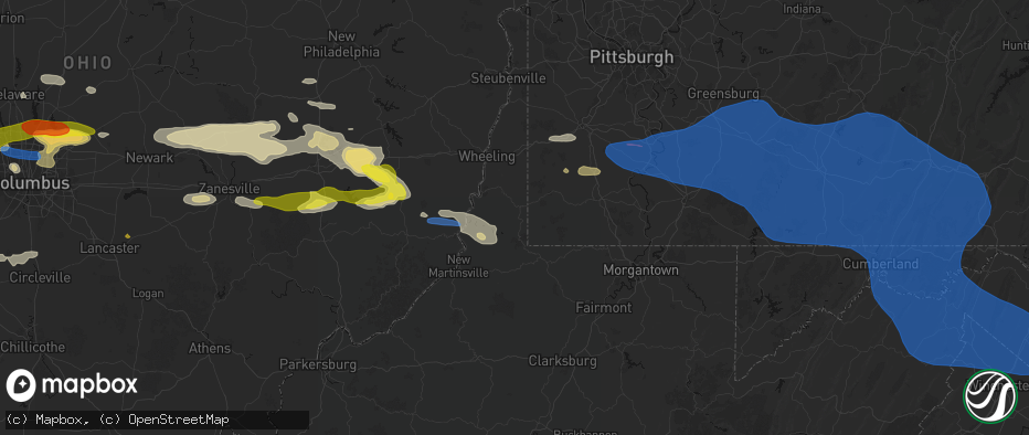
Wind
Tornado
Hail
0
Estimated number of impacted properties by a 1.00" hail or larger0
Estimated number of impacted properties by a 1.75" hail or larger0
Estimated number of impacted properties by a 2.50" hail or largerStorm reports in Cameron, WV
Cameron, WV
| Date | Description |
|---|---|
| 06/06/20261:31 PM CDT | Trees down reported on fish creek road. Time based on radar estimate. |
| 06/06/20261:28 PM CDT | Trees down on cameron ridge. Time based on radar estimate. |
| 06/06/20261:20 PM CDT | Trees reported down on waynesburg pike |
| 06/06/20261:20 PM CDT | Trees down reporte4d on irish ridge. Time based on radar estimate. |
All States Impacted by Hail Map on June 6, 2026
All Cities Impacted by Hail Map on June 6, 2026
- Battle Ground, IN
- West Lafayette, IN
- Lafayette, IN
- Delphi, IN
- Frankfort, IN
- Cutler, IN
- Luverne, ND
- Hannaford, ND
- Marion, IN
- Upland, IN
- Fowlerton, IN
- Gas City, IN
- Fairmount, IN
- Gaston, IN
- Swayzee, IN
- Summitville, IN
- Jonesboro, IN
- Cloverdale, OH
- Kenton, OH
- Belle Center, OH
- Lakeview, OH
- Russells Point, OH
- Huntsville, OH
- Bellefontaine, OH
- Rushsylvania, OH
- Richwood, OH
- Marysville, OH
- Raymond, OH
- Delaware, OH
- Sunbury, OH
- Marengo, OH
- Ashley, OH
- Cardington, OH
- Columbus, OH
- Dublin, OH
- Newark, OH
- Frazeysburg, OH
- Saint Louisville, OH
- Nashport, OH
- Merkel, TX
- Dresden, OH
- Trinway, OH
- Anson, TX
- Andover, OH
- Williamsfield, OH
- Jamestown, PA
- Adamsville, OH
- Townville, PA
- Centerville, PA
- Meadville, PA
- Cochranton, PA
- Guys Mills, PA
- Newcomerstown, OH
- Norwich, OH
- Zanesville, OH
- New Concord, OH
- Titusville, PA
- Hartstown, PA
- Hawley, TX
- Abilene, TX
- Avoca, TX
- Stamford, TX
- Lueders, TX
- Albany, TX
- Ellsworth, PA
- Bentleyville, PA
- Coal Center, PA
- Glen Campbell, PA
- Otterbein, IN
- Baird, TX
- Westpoint, IN
- Marion Center, PA
- Rochester Mills, PA
- Charleroi, PA
- Daisytown, PA
- Fredericktown, PA
- Brownsville, PA
- East Millsboro, PA
- Grindstone, PA
- Hiller, PA
- California, PA
- Allison, PA
- Smock, PA
- New Salem, PA
- Newell, PA
- Fayette City, PA
- Allenport, PA
- Monessen, PA
- Belle Vernon, PA
- Elco, PA
- Roscoe, PA
- Stockdale, PA
- Dunlevy, PA
- Earl Park, IN
- Fowler, IN
- Hillsdale, PA
- Cisco, TX
- Moran, TX
- Cherry Tree, PA
- Ridgway, PA
- Star Junction, PA
- Keisterville, PA
- Waltersburg, PA
- West Leisenring, PA
- Uniontown, PA
- Mount Braddock, PA
- Dunbar, PA
- Vanderbilt, PA
- Perryopolis, PA
- Lemont Furnace, PA
- Smithton, PA
- Wickhaven, PA
- Dawson, PA
- Mill Run, PA
- Dickerson Run, PA
- Connellsville, PA
- Ohiopyle, PA
- Mount Pleasant, PA
- Everson, PA
- Scottdale, PA
- New Stanton, PA
- Alverton, PA
- Hunker, PA
- Tarrs, PA
- Ruffs Dale, PA
- Brockport, PA
- Confluence, PA
- Acme, PA
- Normalville, PA
- White, PA
- Greensburg, PA
- Indian Head, PA
- Rockwood, PA
- Stahlstown, PA
- Pleasant Unity, PA
- Latrobe, PA
- Melcroft, PA
- Champion, PA
- Donegal, PA
- Youngwood, PA
- Cokeburg, PA
- Scenery Hill, PA
- Eighty Four, PA
- Richeyville, PA
- Beallsville, PA
- Marianna, PA
- Denbo, PA
- Vestaburg, PA
- La Belle, PA
- Merrittstown, PA
- Hostetter, PA
- Jones Mills, PA
- Breckenridge, TX
- Addison, PA
- Ligonier, PA
- Markleton, PA
- Fort Hill, PA
- Somerset, PA
- Laughlintown, PA
- Hidden Valley, PA
- Rector, PA
- Newcastle, TX
- Olney, TX
- Saint Joseph, MO
- Loving, TX
- Salisbury, PA
- Boynton, PA
- West Salisbury, PA
- Springs, PA
- Garrett, PA
- Meyersdale, PA
- Berlin, PA
- Buffalo Mills, PA
- Hyndman, PA
- Bedford, PA
- Fairhope, PA
- Friedens, PA
- Acosta, PA
- Gray, PA
- Boswell, PA
- Quecreek, PA
- Stoystown, PA
- Hooversville, PA
- Shanksville, PA
- Schellsburg, PA
- Jenners, PA
- Cairnbrook, PA
- Manns Choice, PA
- Davidsville, PA
- Hollsopple, PA
- Seanor, PA
- Jerome, PA
- Windber, PA
- Central City, PA
- Jennerstown, PA
- Mill Hall, PA
- Loganton, PA
- Lock Haven, PA
- Rebersburg, PA
- Jacksboro, TX
- Windthorst, TX
- New Paris, PA
- Fishertown, PA
- Alum Bank, PA
- Maysville, MO
- Axtell, KS
- Baileyville, KS
- Roaring Branch, PA
- Ralston, PA
- Trout Run, PA
- Rensselaer, IN
- Henrietta, TX
- Wiley Ford, WV
- Mount Savage, MD
- Wellersburg, PA
- Ellerslie, MD
- Cumberland, MD
- Corriganville, MD
- Frostburg, MD
- Ridgeley, WV
- Oldtown, MD
- Flintstone, MD
- Everett, PA
- Artemas, PA
- Clearville, PA
- Mifflinburg, PA
- Laurelton, PA
- Allenwood, PA
- Lewisburg, PA
- New Columbia, PA
- Roscoe, NY
- Amity, MO
- Urbana, OH
- Fort Loudon, PA
- Spickard, MO
- North Lewisburg, OH
- Cable, OH
- Woodstock, OH
- Sabetha, KS
- Equinunk, PA
- Long Eddy, NY
- Hankins, NY
- Mechanicsburg, OH
- Milford Center, OH
- Milton, PA
- Selinsgrove, PA
- Shamokin Dam, PA
- New Berlin, PA
- Winfield, PA
- West Milton, PA
- Montandon, PA
- Danville, PA
- Northumberland, PA
- Fort Ashby, WV
- Springfield, WV
- Green Spring, WV
- Breezewood, PA
- Crystal Spring, PA
- Warfordsburg, PA
- Great Cacapon, WV
- Hancock, MD
- Levels, WV
- Little Orleans, MD
- Romney, WV
- Slanesville, WV
- Paw Paw, WV
- Points, WV
- Augusta, WV
- Berkeley Springs, WV
- Middleburg, PA
- Saint Thomas, PA
- Chambersburg, PA
- Galt, MO
- Rome, PA
- Parksville, NY
- Liberty, NY
- Callicoon, NY
- North Branch, NY
- Fremont Center, NY
- Irwin, OH
- London, OH
- Plain City, OH
- Rossburg, OH
- New Weston, OH
- Upperstrasburg, PA
- Springer, NM
- Thorntown, IN
- Brownwood, TX
- Colfax, IN
- Burchard, NE
- Sunbury, PA
- Bloomsburg, PA
- Riverside, PA
- Paxinos, PA
- Port Trevorton, PA
- Dornsife, PA
- Herndon, PA
- Freeburg, PA
- Lykens, PA
- Dalmatia, PA
- Gratz, PA
- Elizabethville, PA
- Berrysburg, PA
- Jeffersonville, NY
- Swan Lake, NY
- White Sulphur Springs, NY
- Youngsville, NY
- Livingston Manor, NY
- Millerstown, PA
- Newport, PA
- Neversink, NY
- Woodbourne, NY
- Millersburg, PA
- Pillow, PA
- Mount Pleasant Mills, PA
- Saint Henry, OH
- Bloomery, WV
- Capon Bridge, WV
- Cross Junction, VA
- Martinsburg, WV
- Hedgesville, WV
- Inwood, WV
- Gerrardstown, WV
- Glengary, WV
- Winchester, VA
- High View, WV
- Gore, VA
- Pitman, PA
- Trevorton, PA
- Hegins, PA
- Shamokin, PA
- Catawissa, PA
- Rebuck, PA
- Klingerstown, PA
- Coal Township, PA
- Leck Kill, PA
- Elysburg, PA
- Kulpmont, PA
- Wilburton, PA
- Marion Heights, PA
- Mount Carmel, PA
- Locust Gap, PA
- Powell, OH
- Maryneal, TX
- Hurleyville, NY
- Ferndale, NY
- Grahamsville, NY
- Loch Sheldrake, NY
- Sacramento, PA
- Bridgeport, TX
- Springer, OK
- Davis, OK
- Robert Lee, TX
- New Bloomfield, PA
- Las Vegas, NM
- Halifax, PA
- Liverpool, PA
- Clarks Hill, IN
- Elliottsburg, PA
- Ostrander, OH
- Amlin, OH
- Lewis Center, OH
- Westerville, OH
- Clear Brook, VA
- Bunker Hill, WV
- Stephenson, VA
- Summit Point, WV
- Berryville, VA
- Kearneysville, WV
- Ashland, PA
- Ranson, WV
- Charles Town, WV
- Shenandoah Junction, WV
- Put In Bay, OH
- Duncannon, PA
- Stone Ridge, NY
- Cottekill, NY
- Accord, NY
- Kingston, NY
- Dillsburg, PA
- York Springs, PA
- East Berlin, PA
- Galena, OH
- Johnstown, OH
- Des Moines, NM
- Healdton, OK
- Lakeside Marblehead, OH
- Lancaster, OH
- Pleasantville, OH
- Wellsville, PA
- Blackwell, TX
- Tillson, NY
- Rosendale, NY
- Ulster Park, NY
- High Falls, NY
- New Paltz, NY
- Baltimore, OH
- Dauphin, PA
- Wilson, OK
- Ringling, OK
- New Albany, OH
- Highland, NY
- Hyde Park, NY
- Staatsburg, NY
- Poughkeepsie, NY
- Millersport, OH
- Bronte, TX
- Mount Perry, OH
- Justin, TX
- Rushville, OH
- Bremen, OH
- Pine Village, IN
- Sandusky, OH
- Decatur, TX
- Paradise, TX
- Galloway, OH
- West Liberty, OH
- De Graff, OH
- South Vienna, OH
- Bloomington, NY
- Pleasant Valley, NY
- Huron, OH
- Cheshire, MA
- Chandlersville, OH
- Blue Rock, OH
- Philo, OH
- Duncan Falls, OH
- Wingate, TX
- Ponder, TX
- Mullin, TX
- Milan, OH
- Salt Point, NY
- Delia, KS
- Emmett, KS
- Krum, TX
- Millersview, TX
- Zephyr, TX
- Early, TX
- Pittsfield, MA
- East Nassau, NY
- Stephentown, NY
- New Lebanon, NY
- Weatherford, TX
- Leon, OK
- Cumberland, OH
- Cambridge, OH
- Pleasant City, OH
- Byesville, OH
- Senecaville, OH
- Collins, OH
- Rowe, MA
- Adams, MA
- Savoy, MA
- Drury, MA
- Kimbolton, OH
- Freeport, OH
- Azle, TX
- Fort Worth, TX
- Quaker City, OH
- Salesville, OH
- Lore City, OH
- Gainesville, TX
- Muenster, TX
- Lindsay, TX
- Paint Rock, TX
- Orwell, VT
- Ticonderoga, NY
- Putnam Station, NY
- Burneyville, OK
- Attica, IN
- Williamsport, IN
- Tuscola, TX
- Romney, IN
- New Richmond, IN
- Barnesville, OH
- Conesville, OH
- Canal Winchester, OH
- Carroll, OH
- Brandon, VT
- Whiting, VT
- Summerfield, OH
- Wingate, IN
- Roy, NM
- Dublin, TX
- Ada, OK
- Haslet, TX
- Jerusalem, OH
- Trinidad, CO
- Model, CO
- Monroeville, OH
- Pittsford, VT
- Fair Haven, VT
- Hico, TX
- Coshocton, OH
- Deer Trail, CO
- Keller, TX
- Talpa, TX
- Goldthwaite, TX
- Priddy, TX
- Veedersburg, IN
- Gustine, TX
- Comanche, TX
- Hamilton, TX
- Villisca, IA
- Mosquero, NM
- Stephenville, TX
- Newtown, IN
- Hillsboro, IN
- Waynetown, IN
- Wakeman, OH
- New London, OH
- Wellington, OH
- Castleton, VT
- Florence, VT
- Mellott, IN
- Beallsville, OH
- Novice, TX
- Santa Anna, TX
- Bangs, TX
- Old Washington, OH
- Whitesboro, TX
- Nova, OH
- Sullivan, OH
- West Salem, OH
- Ashland, OH
- Corning, IA
- Nodaway, IA
- Cuervo, NM
- Ashville, OH
- Williamsport, OH
- Coleman, TX
- Tucumcari, NM
- Elliott, IA
- Carlton, TX
- Mount Sterling, OH
- Bomoseen, VT
- Pittsfield, VT
- Fort Morgan, CO
- Proctor, WV
- Clarington, OH
- Powhatan Point, OH
- Sadler, TX
- Polk, OH
- Stonewall, OK
- Allen, OK
- Washington, PA
- Claysville, PA
- West Alexander, PA
- West Finley, PA
- House, NM
- Griswold, IA
- Prosperity, PA
- Graysville, PA
- Circleville, OH
- Hot Springs, SD
- Cameron, WV
- Glen Easton, WV
- Moundsville, WV
- Moonachie, NJ
- Bronxville, NY
- Elmwood Park, NJ
- Montclair, NJ
- Hastings On Hudson, NY
- Little Falls, NJ
- Haworth, NJ
- Cresskill, NJ
- East Orange, NJ
- Carlstadt, NJ
- Leonia, NJ
- Ridgefield, NJ
- Closter, NJ
- Elizabeth, NJ
- Hasbrouck Heights, NJ
- Kearny, NJ
- Yonkers, NY
- Demarest, NJ
- Bogota, NJ
- Bronx, NY
- Bergenfield, NJ
- Hackensack, NJ
- Garfield, NJ
- Maywood, NJ
- Clifton, NJ
- Teterboro, NJ
- Fort Lee, NJ
- Wallington, NJ
- North Bergen, NJ
- Passaic, NJ
- Saddle Brook, NJ
- Alpine, NJ
- Eastchester, NY
- East Rutherford, NJ
- Englewood, NJ
- Englewood Cliffs, NJ
- River Edge, NJ
- Lodi, NJ
- Hillside, NJ
- Scarsdale, NY
- Teaneck, NJ
- New Milford, NJ
- White Plains, NY
- Rochelle Park, NJ
- Rutherford, NJ
- Hartsdale, NY
- Ardsley, NY
- Harrison, NJ
- Belleville, NJ
- Glen Ridge, NJ
- Paramus, NJ
- Tenafly, NJ
- Little Ferry, NJ
- West Harrison, NY
- Secaucus, NJ
- Wood Ridge, NJ
- Dumont, NJ
- Newark, NJ
- Ridgefield Park, NJ
- Lyndhurst, NJ
- Tuckahoe, NY
- Irvington, NJ
- Oradell, NJ
- Palisades Park, NJ
- Bloomfield, NJ
- South Hackensack, NJ
- Nutley, NJ
- North Arlington, NJ
- Paterson, NJ
- Fair Lawn, NJ
- Totowa, NJ
- Verona, NJ
- Orange, NJ
- Cedar Grove, NJ
- West Orange, NJ
- South Orange, NJ
- Union, NJ
- Maplewood, NJ
- Jersey City, NJ
- Union City, NJ
- Cliffside Park, NJ
- Fairview, NJ
- Weehawken, NJ
- Staten Island, NY
- West New York, NJ
- New York, NY
- Edgewater, NJ
- Elizabethport, NJ
- Astoria, NY
- Hoboken, NJ
- Long Island City, NY
- Mount Vernon, NY
- Bayonne, NJ
- New Rochelle, NY
- Brooklyn, NY
- Pelham, NY
- Sunnyside, NY
- Larchmont, NY
- Woodside, NY
- East Elmhurst, NY
- Flushing, NY
- Rye, NY
- Mamaroneck, NY
- Harrison, NY
- Maspeth, NY
- College Point, NY
- Middle Village, NY
- Corona, NY
- Elmhurst, NY
- Jackson Heights, NY
- Ridgewood, NY
- Ozone Park, NY
- Whitestone, NY
- Woodhaven, NY
- Rego Park, NY
- Forest Hills, NY
- Ossining, NY
- Pleasantville, NY
- Valhalla, NY
- Sparkill, NY
- Orangeburg, NY
- Tarrytown, NY
- Hawthorne, NY
- Briarcliff Manor, NY
- Elmsford, NY
- Harrington Park, NJ
- Blauvelt, NY
- Westwood, NJ
- Norwood, NJ
- Dobbs Ferry, NY
- Irvington, NY
- Emerson, NJ
- Nyack, NY
- Palisades, NY
- Piermont, NY
- Northvale, NJ
- Tappan, NY
- Valley Cottage, NY
- Congers, NY
- Croton On Hudson, NY
- Crawfordsville, IN
- Snyder, CO
- Nineveh, PA
- Sycamore, PA
- Amity, PA
- Waynesburg, PA
- Wilton, CT
- Bedford, NY
- New Canaan, CT
- Stamford, CT
- Chappaqua, NY
- Armonk, NY
- Thornwood, NY
- Katonah, NY
- South Salem, NY
- Greenwich, CT
- Pound Ridge, NY
- Purchase, NY
- Millwood, NY
- Port Chester, NY
- Mount Kisco, NY
- Bedford Hills, NY
- Ridgefield, CT
- Cross River, NY
- Yorktown Heights, NY
- Redding, CT
- Cos Cob, CT
- Elmont, NY
- Manhasset, NY
- Floral Park, NY
- Glen Cove, NY
- Kew Gardens, NY
- Albertson, NY
- Roosevelt, NY
- Garden City, NY
- Great Neck, NY
- Lynbrook, NY
- Sea Cliff, NY
- Glen Head, NY
- South Richmond Hill, NY
- Richmond Hill, NY
- Greenvale, NY
- Baldwin, NY
- Westbury, NY
- Jamaica, NY
- Rosedale, NY
- Locust Valley, NY
- Saint Albans, NY
- Uniondale, NY
- Freeport, NY
- Glen Oaks, NY
- Little Neck, NY
- Williston Park, NY
- Oyster Bay, NY
- Fresh Meadows, NY
- Howard Beach, NY
- South Ozone Park, NY
- Cambria Heights, NY
- Valley Stream, NY
- New Hyde Park, NY
- Hempstead, NY
- Port Washington, NY
- Rockville Centre, NY
- Bellerose, NY
- Bayside, NY
- Queens Village, NY
- Glenwood Landing, NY
- Oakland Gardens, NY
- Franklin Square, NY
- Mineola, NY
- Mill Neck, NY
- Far Rockaway, NY
- Malverne, NY
- West Hempstead, NY
- Bayville, NY
- Hollis, NY
- Roslyn, NY
- Springfield Gardens, NY
- Old Westbury, NY
- Carle Place, NY
- Roslyn Heights, NY
- West Lafayette, OH
- Fresno, OH
- West Nyack, NY
- Cold Spring Harbor, NY
- Levittown, NY
- Massapequa, NY
- Riverside, CT
- Hewlett, NY
- Cedarhurst, NY
- Old Greenwich, CT
- Darien, CT
- Melville, NY
- Oceanside, NY
- Huntington, NY
- Inwood, NY
- East Norwich, NY
- Norwalk, CT
- Bethpage, NY
- Old Bethpage, NY
- Farmingdale, NY
- Massapequa Park, NY
- Wantagh, NY
- Woodbury, NY
- Plainview, NY
- Lawrence, NY
- Merrick, NY
- Syosset, NY
- East Rockaway, NY
- Woodmere, NY
- Huntington Station, NY
- Hicksville, NY
- Bellmore, NY
- Weston, CT
- Seaford, NY
- Jericho, NY
- East Meadow, NY
- Arverne, NY
- Island Park, NY
- Rockaway Park, NY
- Atlantic Beach, NY
- Long Beach, NY
- Point Lookout, NY
- Babylon, NY
- Westport, CT
- Easton, CT
- Amityville, NY
- Centerport, NY
- Fairfield, CT
- Northport, NY
- Caldwell, NJ
- Kingman, IN
- Alamo, IN
- Hillrose, CO
- Brush, CO
- Greenlawn, NY
- Southport, CT
- Pottsville, TX
- Eagle Pass, TX
- Quemado, TX
- Bridgeport, CT
- Joshua, TX
- Cleburne, TX
- Mckinney, TX
- Anna, TX
- Melissa, TX
- Fort Wayne, IN
- Iredell, TX
- Reynoldsburg, OH
- Alexandria, OH
- Pataskala, OH
- May, TX
- Centerburg, OH
- Blue Ridge, TX
- Burleson, TX
- Alvarado, TX
- Winamac, IN
- Fulton, OH
- Blacklick, OH
- Clarksville, PA
- Etna, OH
- Van Alstyne, TX
- Campton, NH
- Rumney, NH
- Woodsfield, OH
- Cranfills Gap, TX
- Leonard, TX
- Whitewright, TX
- Trenton, TX
- Colorado Springs, CO
- Venus, TX
- Hoagland, IN
- Decatur, IN
- Lillian, TX
- Mansfield, TX
- Lanesborough, MA
- Midlothian, TX
- Grand Prairie, TX
- Red Oak, TX
- Cedar Hill, TX
- Desoto, TX
- Lancaster, TX
- Fortuna, ND
- Crosby, ND
- Ambrose, ND
- Meridian, TX
- Dallas, TX
- Convoy, OH
- Van Wert, OH
- Haviland, OH
- Scott, OH
- Payne, OH
- Duncanville, TX
- Crystal City, TX
- Clifton, TX
- Rachel, WV
- Mannington, WV
- Farmington, WV
- Florissant, CO
- Alzada, MT
- Buffalo, SD
- Fountain, CO
- Wilmer, TX
- Ferris, TX
- Hutchins, TX
- Camp Crook, SD
- Farwell, TX
- Lindsay, MT
- Bloomfield, MT
- Seagoville, TX
- Forney, TX
- Crandall, TX
- Muleshoe, TX
- Cohagen, MT
- Friona, TX
- Maypearl, TX
- Grandview, TX
- Italy, TX
- Waxahachie, TX
- Bluff Dale, TX
- Walnut Springs, TX
- Glen Rose, TX
- Richey, MT
- Brockton, MT
- Terrell, TX
- Forreston, TX
- Lambert, MT
- Fairview, MT
- Milford, IL
- Tolar, TX
- Culbertson, MT
- Vida, MT
- Ennis, TX
- Palmer, TX
- Circle, MT
- Wolf Point, MT
- Edgemont, SD
- Homestead, MT
- Poplar, MT
- Froid, MT
- Bainville, MT
- Medicine Lake, MT
- Terry, MT
- Custer, SD
- Dilley, TX
- Brockway, MT
- Hill City, SD
- Dagmar, MT
- Alvord, TX
- Shallowater, TX
- Lubbock, TX
- Idalou, TX
- Slaton, TX
- Grenora, ND
- Morgan, TX
- Alba, TX
- Emory, TX
- Lead, SD
- Zahl, ND
- Lorenzo, TX
- Ralls, TX
- Post, TX
- Ransom Canyon, TX
- Quitman, TX
- Forsyth, MT
- Como, TX
- Pickton, TX
- Winnsboro, TX
- Yantis, TX
- Angela, MT
- Alamo, ND
- Cartwright, ND
- Grassy Butte, ND
- Keene, TX
- Watford City, ND
- Arnegard, ND
- Arlington, TX
- Keene, ND
- New Town, ND
- Mandaree, ND
- Kaufman, TX
- Parshall, ND
- Palermo, ND
- Stanley, ND
- Quinlan, TX
- Plaza, ND
- Williston, ND
- Donnybrook, ND
- Epping, ND
- Ray, ND
- Carpio, ND
- Newburg, ND
- Westhope, ND
- Mohall, ND
- Lansford, ND
- Souris, ND
- Maxbass, ND
- Electra, TX
- Bottineau, ND
- Huntington, AR
- Greenwood, AR
- Saddle River, NJ
- Madison, NJ
- Glen Rock, NJ
- Hibernia, NJ
- Mountain Lakes, NJ
- Oakland, NJ
- Cedar Knolls, NJ
- Essex Fells, NJ
- Fairfield, NJ
- Ridgewood, NJ
- Towaco, NJ
- Franklin Lakes, NJ
- Mine Hill, NJ
- Dover, NJ
- Pompton Lakes, NJ
- Hillsdale, NJ
- Monsey, NY
- Waldwick, NJ
- Wharton, NJ
- Park Ridge, NJ
- Livingston, NJ
- Mendham, NJ
- Roseland, NJ
- Rockaway, NJ
- Lake Hiawatha, NJ
- New City, NY
- Boonton, NJ
- Vauxhall, NJ
- Montville, NJ
- Spring Valley, NY
- Allendale, NJ
- Midland Park, NJ
- Short Hills, NJ
- Morristown, NJ
- Hawthorne, NJ
- Denville, NJ
- Parsippany, NJ
- Chatham, NJ
- East Hanover, NJ
- Pompton Plains, NJ
- Township Of Washington, NJ
- Florham Park, NJ
- Woodcliff Lake, NJ
- Pine Brook, NJ
- Mount Tabor, NJ
- Ho Ho Kus, NJ
- Lincoln Park, NJ
- Randolph, NJ
- Montvale, NJ
- Wayne, NJ
- Haledon, NJ
- Millburn, NJ
- Whippany, NJ
- Pearl River, NY
- Wyckoff, NJ
- Butler, NJ
- Morris Plains, NJ
- Mahwah, NJ
- Pequannock, NJ
- Ramsey, NJ
- Nanuet, NY
- Clear Spring, MD
- Maugansville, MD
- Waynesboro, PA
- State Line, PA
- Hagerstown, MD
- Greencastle, PA
- Smithsburg, MD
- Muncie, IN
- Albany, IN
- Yorktown, IN
- Weatherford, OK
- Hydro, OK
- Cheyenne, WY
- Fe Warren Afb, WY


