Hail Map in Kansas on June 8, 2026
The weather event in Kansas on June 8, 2026 includes Hail and Wind maps. 12 states and 544 cities were impacted and suffered possible damage. The total estimated number of properties impacted is 20,397.
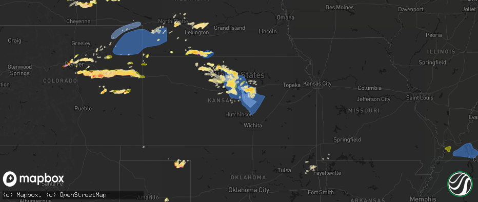
Hail
Wind
20,397
Estimated number of impacted properties by a 1.00" hail or larger1,979
Estimated number of impacted properties by a 1.75" hail or larger0
Estimated number of impacted properties by a 2.50" hail or largerStorm reports in Kansas
Kansas
| Date | Description |
|---|---|
| 06/08/20266:42 PM CDT | A local report indicates 1.00 inch wind near 8 SSE Glade |
| 06/08/20266:39 PM CDT | A local report indicates 1.00 inch wind near 2 N Portis |
| 06/08/20266:14 PM CDT | A local report indicates 1.75 inch wind near Gaylord |
| 06/08/20266:10 PM CDT | A local report indicates 1.75 inch wind near 7 SSE Logan |
| 06/08/20265:49 PM CDT | A local report indicates 1.00 inch wind near 5 E Phillipsburg |
| 06/08/20265:05 PM CDT | Wind gusts estimated to be near 60 mph...outflow from storms to the north. |
| 06/08/20261:40 AM CDT | Social media photos of hail ranging from quarter to golf ball size. |
| 06/08/20261:25 AM CDT | A local report indicates 1.00 inch wind near 1 N Hays |
| 06/08/20261:14 AM CDT | Downed tree and wires near nall avenue. Time confirmed from radar. |
| 06/08/20261:05 AM CDT | A tree fell on a house... Power lines down with tree limbs on them. |
| 06/08/20261:05 AM CDT | Downed trees and wires near 191st street. Time estimated from radar. |
| 06/08/20261:01 AM CDT | Private weather sensor. |
| 06/08/20261:00 AM CDT | Photos from social media show large healthy tree branches 8 to 10 inches in diameter broken... And a large somewhat rotted tree snapped. |
| 06/08/20261:00 AM CDT | Multiple reports of downed wires near lake quivira. Time estimated from radar. |
| 06/08/20261:00 AM CDT | Multiple large tree branches snapped and older trees uprooted. Power poles were also blown down along kansas ave. Widespread tree damage was observed from gage park in |
| 06/08/202612:58 AM CDT | Multiple reports of downed wires near trading post. Time estimated from radar. |
| 06/08/202612:53 AM CDT | Asos station kfoe topeka forbes. |
| 06/08/202612:44 AM CDT | Significant tree damage and damage to a barn along 318th st. Time estimated from radar. |
| 06/08/202612:44 AM CDT | Tree limbs up to 2 inches in diameter downed. Time estimated from radar. |
| 06/08/202612:44 AM CDT | Several reports of limbs and wires down in the paola area. Time estimated from radar. |
| 06/08/202612:41 AM CDT | Downed trees and structure damage in the vicinity of 319th street and lookout. Time estimated from radar. |
| 06/08/202612:41 AM CDT | Damage to a business on lookout road near miami regional airport. Time estimated from radar. |
| 06/08/202612:40 AM CDT | Several reports of tree limbs and wires down in the antioch area. Time estimated from radar. |
| 06/08/202612:40 AM CDT | Tree damage and power outages reported on the back side of the line of storms. |
| 06/08/202612:37 AM CDT | Report from mping: quarter |
| 06/08/202612:34 AM CDT | Corrects |
| 06/08/202612:32 AM CDT | A local report indicates 70 MPH wind near 3 NNW Perry |
| 06/08/202612:31 AM CDT | Several 1-2 inch diameter tree limbs down. Time estimated radar. |
| 06/08/202612:31 AM CDT | A local report indicates 1.00 inch wind near Clinton |
| 06/08/202612:30 AM CDT | A local report indicates 60 MPH wind near 2 N Lawrence |
| 06/08/202612:28 AM CDT | Trees down across roadways and power lines down in north lawrence. Time estimated from radar. |
| 06/08/202612:22 AM CDT | Tree uprooted near kasold drive. Time estimated by radar. |
| 06/08/202612:16 AM CDT | A local report indicates 65 MPH wind near 7 WSW Topeka |
| 06/08/202612:04 AM CDT | A few shingles blown off roof. 6 to 8 inch tree limbs down. Winds estimated 70 mph. |
| 06/07/202611:55 PM CDT | Estimated wind gusts 60-65 mph. |
| 06/07/202611:50 PM CDT | Estimated wind gusts 70-80 mph. |
| 06/07/202611:47 PM CDT | Private weather sensor. |
| 06/07/202611:45 PM CDT | Mesonet station almku alma 5se. |
| 06/07/202611:42 PM CDT | Em reported several power poles down along hwy k4 near 10th ave. |
| 06/07/202611:35 PM CDT | A local report indicates 61 MPH wind near Eskridge |
| 06/07/202611:30 PM CDT | Several power poles downed and scattered tree damage near road x west of reading. |
| 06/07/202611:30 PM CDT | Delayed report. Wind gust measured from kansas state mesonet site. |
| 06/07/202611:21 PM CDT | Power lines down... Resulted in a tree fire. |
| 06/07/202611:15 PM CDT | Reported semi flipped over. |
| 06/07/202611:02 PM CDT | Estimated winds over 65 mph. |
| 06/07/202611:00 PM CDT | Tree and powerline down with pictures. |
| 06/07/202610:55 PM CDT | Measured from a personal weather station. |
| 06/07/202610:52 PM CDT | Asos station kmhk manhattan. |
| 06/07/202610:50 PM CDT | Picture on social media of a large healthy tree split in half. Tree looks to be one to two feet in diameter. |
| 06/07/202610:48 PM CDT | Facebook image of hail compared to penny and poker chip; time estimated from radar. |
| 06/07/202610:48 PM CDT | A local report indicates 65 MPH wind near Bel Aire |
| 06/07/202610:48 PM CDT | Corrects previous hail report from 1 nne goodland. Ongoing 1.25 inch hail at nws goodland. |
| 06/07/202610:48 PM CDT | Ongoing 1 inch hail at nws goodland. |
| 06/07/202610:47 PM CDT | Measured with anemometer. Gusts ranging between 75-79 mph for 10 min. |
| 06/07/202610:45 PM CDT | Heavy rain and damaging wind reported. |
| 06/07/202610:39 PM CDT | A local report indicates 64 MPH wind near 3 NE Ogden |
| 06/07/202610:39 PM CDT | Emergency manager reports up to 90 mph winds with signs folding over between peabody and florence at sunflower and 110th st. |
| 06/07/202610:36 PM CDT | Personal weather station report. |
| 06/07/202610:34 PM CDT | Multiple tree limbs down throughout the city of whitewater... Average limb size of 4-6 inches. Delayed report. Time estimated by radar. |
| 06/07/202610:32 PM CDT | Personal weather station report. |
| 06/07/202610:31 PM CDT | Personal weather station report. |
| 06/07/202610:30 PM CDT | A local report indicates 61 MPH wind near 2 NW Junction City |
| 06/07/202610:30 PM CDT | A local report indicates 60 MPH wind near Herington |
| 06/07/202610:30 PM CDT | Sherman county dispatch reported hail varying from 1-1.75 inch hail in kanorado. |
| 06/07/202610:27 PM CDT | Time estimated from radar. |
| 06/07/202610:25 PM CDT | Ewk reported 84 mph. |
| 06/07/202610:24 PM CDT | 90 mph... Nickel size hail... Heavy rains. |
| 06/07/202610:24 PM CDT | Tree fell on a house. Delayed report. Time estimated from radar. |
| 06/07/202610:23 PM CDT | Personal weather station report. |
| 06/07/202610:23 PM CDT | Personal weather station report. |
| 06/07/202610:21 PM CDT | A local report indicates 80 MPH wind near 1 N Marion |
| 06/07/202610:20 PM CDT | Mesonet station up824 4.8 e chapman |
| 06/07/202610:20 PM CDT | A local report indicates 90 MPH wind near 4 W Lincolnville |
| 06/07/202610:19 PM CDT | Marion reservoir reporting heavy rains... Zero visibility and 65 mph winds. |
| 06/07/202610:16 PM CDT | Pws report. |
| 06/07/202610:14 PM CDT | A local report indicates 70 MPH wind near 5 S Chapman |
| 06/07/202610:10 PM CDT | Measured from a personal weather station. Delayed report. |
| 06/07/202610:10 PM CDT | Agritrails fertilizer plant had its roof blown off. Delayed report. Time estimated from radar. |
| 06/07/202610:05 PM CDT | Measured via anemometer. |
| 06/07/202610:03 PM CDT | A local report indicates 64 MPH wind near 4 NNW Durham |
| 06/07/202610:00 PM CDT | Public report of trees down and estimated wind speeds of 60 mph. |
| 06/07/20269:59 PM CDT | Mpr asos measured 59 mph. |
| 06/07/20269:58 PM CDT | Several trees down in durham. Delayed report. Time estimated from radar. |
| 06/07/20269:50 PM CDT | Delayed report. Peak 10-meter wind gust measured from a kansas state mesonet site in gypsum. The 2-meter wind gust was 71 mph. |
| 06/07/20269:45 PM CDT | Spotter reported 80 mph and power poles snapping. |
| 06/07/20269:41 PM CDT | A local report indicates 80 MPH wind near 6 N Mcpherson |
| 06/07/20269:40 PM CDT | Kdot reported i-70 closed between mile markers 219 and 233 due to semis tipped over and severe weather. Time estimated from radar. |
| 06/07/20269:40 PM CDT | Shared through social media - large tree uprooted and laying across part of hwy 40. |
| 06/07/20269:33 PM CDT | Corrects previous tstm wnd dmg report from 4 w lindsborg. Em reported several power poles down along hwy k4 near 10th ave. |
| 06/07/20269:30 PM CDT | Measured 111 mph on vehicle mounted anemometer. Multiple utility poles broken and some trees debarked along hwy 4. |
| 06/07/20269:30 PM CDT | Airport hangar is partially collapsed. Delayed report and time estimated by radar. |
| 06/07/20269:30 PM CDT | Trees uprooted and power lines down; time estimated from radar. |
| 06/07/20269:23 PM CDT | Measured from a personal weather station west of salina regional airport. |
| 06/07/20269:22 PM CDT | A local report indicates 62 MPH wind near 8 ENE Kanopolis |
| 06/07/20269:21 PM CDT | Wind gust from thunderstorm outflow at great bend municipal airport. |
| 06/07/20269:20 PM CDT | Photo shared over social media of metal railroad crossing down. |
| 06/07/20269:20 PM CDT | A local report indicates 70 MPH wind near 7 SSE Solomon |
| 06/07/20269:18 PM CDT | Possible 113 mph wind gust measured at salina regional airport. Supported by county em. Will need to be investigated. |
| 06/07/20269:13 PM CDT | A local report indicates 1.50 inch wind near 4 N Salina |
| 06/07/20269:10 PM CDT | Sln asos measured 59 mph. |
| 06/07/20269:07 PM CDT | A local report indicates 65 MPH wind near 6 NNW Gypsum |
| 06/07/20269:03 PM CDT | Sn115. |
| 06/07/20269:01 PM CDT | A local report indicates 70 MPH wind near 6 NNW Smolan |
| 06/07/20269:00 PM CDT | A local report indicates 64 MPH wind near 1 NW Ellsworth |
| 06/07/20268:59 PM CDT | Ping pong to golf ball size hail. |
| 06/07/20268:55 PM CDT | 100 foot by 80 foot steel barn destroyed via photos. Delayed report and time estimated by radar. |
| 06/07/20268:50 PM CDT | Large trees blown down. Estimated 80 mph winds. |
| 06/07/20268:50 PM CDT | A local report indicates 1.75 inch wind near 1 W Solomon |
| 06/07/20268:50 PM CDT | Collapsed grain bin via photo. Time estimated report. |
| 06/07/20268:50 PM CDT | Delayed report - emergency manager reported several buildings missing roofs... 12 inch diameter trees down... And trees on houses. |
| 06/07/20268:46 PM CDT | A local report indicates 1.75 inch wind near New Cambria |
| 06/07/20268:40 PM CDT | Corrects previous tstm wnd dmg report from 7 sw westfall. Kdot reported i-70 closed between mile markers 219 and 233 due to semis tipped over and severe weather. Time e |
| 06/07/20268:33 PM CDT | Estimated at least 70 mph... Possibly stronger - had to pull over and could not see farther than a few inches in front of the car. |
| 06/07/20268:32 PM CDT | Power lines downed and power outage in minneapolis... Ks. |
| 06/07/20268:31 PM CDT | A local report indicates 58 MPH wind near 5 ENE Lincoln |
| 06/07/20268:25 PM CDT | Delayed report. 10-meter wind gust measured from a kansas state mesonet site 1nw of denmark. The 2-meter wind gust was 68 mph. |
| 06/07/20268:23 PM CDT | Semi flipped over mile marker 255. Delayed report. Time estimated from radar. |
| 06/07/20268:21 PM CDT | Power is reported to be out and a few power poles leaning;time estimated from radar. |
| 06/07/20268:08 PM CDT | Power poles down along n and p roads between 280 and 290. |
| 06/07/20268:05 PM CDT | Personal weather station. |
| 06/07/20267:42 PM CDT | Some tree damage in town. |
| 06/07/20267:35 PM CDT | A local report indicates 59 MPH wind near 2 E Tipton |
| 06/07/20267:35 PM CDT | Wind gusts were estimated to be at least 60 mph...accompanied by dime size hail. |
| 06/07/20267:35 PM CDT | Several reports of overturned pivots... Damage to metal grain bins and snapped tree branches up to 10 inches in diameter around town. |
| 06/07/20267:34 PM CDT | A local report indicates 1.00 inch wind near 3 E Codell |
| 06/07/20267:27 PM CDT | A local report indicates 1.00 inch wind near 1 ENE Codell |
| 06/07/20267:17 PM CDT | Destroyed grain bin. |
| 06/07/20267:17 PM CDT | Parked semi overturned. |
| 06/07/20267:14 PM CDT | A local report indicates 64 MPH wind near 3 NW Cawker City |
| 06/07/20267:13 PM CDT | Overturned center irrigation pivot. |
All States Impacted by Hail Map on June 8, 2026
Cities Impacted by Hail Map on June 8, 2026
- Wallace, NE
- Arnold, NE
- North Platte, NE
- Madrid, NE
- Stapleton, NE
- Maxwell, NE
- Strang, OK
- Vinita, OK
- Spavinaw, OK
- Elsie, NE
- Grant, NE
- Colcord, OK
- Eucha, OK
- Jay, OK
- Rose, OK
- Kansas, OK
- Brady, NE
- Twin Oaks, OK
- Watts, OK
- Kismet, KS
- Tahlequah, OK
- Locust Grove, OK
- Oaks, OK
- Peggs, OK
- Gothenburg, NE
- Cozad, NE
- Hulbert, OK
- Lexington, NE
- Oconto, NE
- Callaway, NE
- Eddyville, NE
- Noel, MO
- Pineville, MO
- Sumner, NE
- Rocky Comfort, MO
- Miller, NE
- Exeter, MO
- Washburn, MO
- Pleasanton, NE
- Amherst, NE
- Mason City, NE
- Seligman, MO
- Wauneta, NE
- Sutherland, NE
- Hayes Center, NE
- Maywood, NE
- Curtis, NE
- Wheatland, WY
- Wilsonville, NE
- Eustis, NE
- Moorefield, NE
- Lebanon, NE
- Hendley, NE
- Wellfleet, NE
- Beaver City, NE
- Bartley, NE
- Arapahoe, NE
- Edison, NE
- Yoder, WY
- Holbrook, NE
- Oxford, NE
- Golden, CO
- Wheat Ridge, CO
- Arvada, CO
- Rush, CO
- Cambridge, NE
- Culbertson, NE
- Orleans, NE
- Stamford, NE
- Broomfield, CO
- Hugo, CO
- Sedalia, CO
- Matheson, CO
- Denver, CO
- Englewood, CO
- Castle Rock, CO
- Parker, CO
- Commerce City, CO
- Booker, TX
- Ramah, CO
- Evergreen, CO
- Alma, NE
- Westminster, CO
- Long Island, KS
- Franktown, CO
- Levelland, TX
- Portland, AR
- Keyes, OK
- Follett, TX
- Thornton, CO
- Elizabeth, CO
- Republican City, NE
- Phillipsburg, KS
- Naponee, NE
- Parkdale, AR
- Kress, TX
- Goodwell, OK
- Brighton, CO
- Fort Lupton, CO
- Aurora, CO
- Kiowa, CO
- Hudson, CO
- Bennett, CO
- Watkins, CO
- Pecos, TX
- Karval, CO
- Lenora, KS
- Wray, CO
- Idalia, CO
- Saint Francis, KS
- Kit Carson, CO
- Wild Horse, CO
- Strasburg, CO
- Alton, KS
- Gaylord, KS
- Logan, KS
- Stockton, KS
- Bogue, KS
- Chugwater, WY
- Silverton, TX
- Portis, KS
- Downs, KS
- Deer Trail, CO
- Agra, KS
- Bloomington, NE
- Weldona, CO
- Fort Morgan, CO
- Byers, CO
- Glade, KS
- Agate, CO
- Clarendon, TX
- Almena, KS
- Roggen, CO
- Wiggins, CO
- Perryton, TX
- Kirwin, KS
- Kensington, KS
- Bardwell, KY
- Cheyenne, WY
- Cedar, KS
- Canadian, TX
- Wickliffe, KY
- Lubbock, TX
- Arlington, KY
- Cunningham, KY
- Fancy Farm, KY
- Esbon, KS
- Snyder, CO
- Brush, CO
- Hillrose, CO
- Keenesburg, CO
- Bayard, NE
- Minatare, NE
- Woodrow, CO
- Shallowater, TX
- Limon, CO
- Akron, CO
- Veteran, WY
- Gering, NE
- Scottsbluff, NE
- Cawker City, KS
- Glen Elder, KS
- Osborne, KS
- Merino, CO
- Woodston, KS
- Plainville, KS
- Parks, NE
- Haigler, NE
- Genoa, CO
- Arriba, CO
- Natoma, KS
- Angora, NE
- Waldo, KS
- Sterling, CO
- Mankato, KS
- Lagrange, WY
- Tipton, KS
- Beloit, KS
- Hunter, KS
- Ropesville, TX
- Darrouzett, TX
- Simla, CO
- Paradise, KS
- Lebanon, KS
- Hawk Springs, WY
- Sylvan Grove, KS
- Lucas, KS
- Luray, KS
- Meadow, TX
- Otis, CO
- Flagler, CO
- Lyman, NE
- Barnard, KS
- Lincoln, KS
- Dorrance, KS
- New Cambria, KS
- Salina, KS
- Tescott, KS
- Hardesty, OK
- Iliff, CO
- Balko, OK
- Crook, CO
- Minneapolis, KS
- Torrington, WY
- Wilson, KS
- Ellsworth, KS
- Simpson, KS
- Bunker Hill, KS
- Chappell, NE
- Yuma, CO
- Russell, KS
- Hickory, KY
- Mayfield, KY
- Kuttawa, KY
- Symsonia, KY
- Farmington, KY
- Gilbertsville, KY
- Wingo, KY
- Princeton, KY
- Kirksey, KY
- Grand Rivers, KY
- Dexter, KY
- Murray, KY
- Benton, KY
- Eddyville, KY
- Sedalia, KY
- Almo, KY
- Calvert City, KY
- Hardin, KY
- Cadiz, KY
- New Concord, KY
- Glasco, KS
- Delphos, KS
- Lorraine, KS
- Beverly, KS
- Seibert, CO
- Joes, CO
- Carlos, MN
- Miltona, MN
- Eagle Bend, MN
- Bennington, KS
- Amherst, CO
- Eckley, CO
- Paoli, CO
- Julesburg, CO
- Sedgwick, CO
- Haxtun, CO
- Ovid, CO
- Holyoke, CO
- Fleming, CO
- Padroni, CO
- Atwood, CO
- Peetz, CO
- Big Springs, NE
- Lodgepole, NE
- Vona, CO
- Solomon, KS
- Kanopolis, KS
- Stratton, CO
- Dover, TN
- Herndon, KY
- Big Rock, TN
- Bumpus Mills, TN
- Abilene, KS
- Brookville, KS
- Geneseo, KS
- Marquette, KS
- Whiteface, TX
- Lindsborg, KS
- Falun, KS
- Bethune, CO
- Kirk, CO
- Champion, NE
- Benkelman, NE
- Venango, NE
- Imperial, NE
- Burlington, CO
- Assaria, KS
- Gypsum, KS
- Alliance, NE
- Longford, KS
- Galva, KS
- Mcpherson, KS
- Hope, KS
- Roxbury, KS
- Durham, KS
- Canton, KS
- Tampa, KS
- Enders, NE
- Lehigh, KS
- Ellsworth, NE
- Little River, KS
- Lyons, KS
- Ramona, KS
- Herington, KS
- Moundridge, KS
- Hillsboro, KS
- Burdick, KS
- Walton, KS
- Lincolnville, KS
- Goessel, KS
- Lost Springs, KS
- Hesston, KS
- North Newton, KS
- Marion, KS
- Newton, KS
- Peabody, KS
- Halstead, KS
- Palisade, NE
- Dickens, NE
- Kanorado, KS
- Wakefield, KS
- Bridgeport, NE
- Goodland, KS
- Chapman, KS
- Woodbine, KS
- Enterprise, KS
- Junction City, KS
- White City, KS
- Whitewater, KS
- Sedgwick, KS
- Valley Center, KS
- Florence, KS
- Wichita, KS
- Benton, KS
- Elbing, KS
- Hershey, NE
- Windom, KS
- Manhattan, KS
- Riley, KS
- Talmage, KS
- Miltonvale, KS
- Clay Center, KS
- Fort Riley, KS
- Milford, KS
- Dwight, KS
- Ogden, KS
- Saint George, KS
- Alta Vista, KS
- Alma, KS
- Wamego, KS
- Greenwich, KS
- Kechi, KS
- Potwin, KS
- Cedar Point, KS
- Burns, KS
- Elmdale, KS
- Council Grove, KS
- Cottonwood Falls, KS
- Wilsey, KS
- Strong City, KS
- Edson, KS
- Towanda, KS
- Rose Hill, KS
- Leon, KS
- Cassoday, KS
- Augusta, KS
- Matfield Green, KS
- Emporia, KS
- Derby, KS
- Douglass, KS
- Rosalia, KS
- El Dorado, KS
- Andover, KS
- Americus, KS
- Allen, KS
- McFarland, KS
- Eskridge, KS
- Paxico, KS
- Belvue, KS
- Maple Hill, KS
- Saint Marys, KS
- Admire, KS
- Reading, KS
- Eureka, KS
- Olpe, KS
- Brewster, KS
- Rossville, KS
- Topeka, KS
- Wakarusa, KS
- Burlingame, KS
- Auburn, KS
- Harveyville, KS
- Carbondale, KS
- Vernon, CO
- Scranton, KS
- Osage City, KS
- Neosho Rapids, KS
- Hartford, KS
- Hamilton, KS
- Madison, KS
- Beaumont, KS
- Latham, KS
- Piedmont, KS
- Silver Lake, KS
- Lebo, KS
- Levant, KS
- Lyndon, KS
- Berryton, KS
- Vassar, KS
- Quenemo, KS
- Waverly, KS
- Burlington, KS
- Melvern, KS
- Neosho Falls, KS
- Virgil, KS
- Severy, KS
- Toronto, KS
- Yates Center, KS
- Le Roy, KS
- Gridley, KS
- Neal, KS
- Delia, KS
- Tecumseh, KS
- Meriden, KS
- Overbrook, KS
- Grantville, KS
- Fall River, KS
- Piqua, KS
- Westphalia, KS
- Oskaloosa, KS
- Perry, KS
- Lecompton, KS
- Ozawkie, KS
- Pomona, KS
- Lawrence, KS
- Ottawa, KS
- McLouth, KS
- Tonganoxie, KS
- Williamsburg, KS
- Baldwin City, KS
- De Soto, KS
- Gardner, KS
- Eudora, KS
- Wellsville, KS
- Olathe, KS
- Basehor, KS
- Welda, KS
- Richmond, KS
- Bonner Springs, KS
- Rantoul, KS
- Edgerton, KS
- Linwood, KS
- Colony, KS
- Garnett, KS
- Kansas City, KS
- Princeton, KS
- Lenexa, KS
- Shawnee, KS
- Paola, KS
- Spring Hill, KS
- Centerville, KS
- La Cygne, KS
- Mound City, KS
- Lane, KS
- Blue Mound, KS
- Greeley, KS
- Fontana, KS
- Osawatomie, KS
- New Century, KS
- Parker, KS
- Kincaid, KS
- Ellis, KS
- Mission, KS
- Louisburg, KS
- Stilwell, KS
- Overland Park, KS
- Prairie Village, KS
- Bucyrus, KS
- Leawood, KS
- Belton, MO
- Kansas City, MO
- Cleveland, MO
- Drexel, MO
- Pleasanton, KS
- Grandview, MO
- Peculiar, MO
- Freeman, MO
- Amsterdam, MO
- Adrian, MO
- Butler, MO
- Archie, MO
- Lees Summit, MO
- Raymore, MO
- Greenwood, MO
- Pleasant Hill, MO
- Harrisonville, MO
- La Harpe, KS
- Iola, KS
- Humboldt, KS
- Hays, KS
- Erie, KS
- Savonburg, KS
- Elsmore, KS
- Moran, KS
- Victoria, KS
- Uniontown, KS
- Gorham, KS
- Strasburg, MO
- East Lynne, MO
- Holden, MO
- Warrensburg, MO
- Chilhowee, MO
- Garden City, MO
- Creighton, MO
- Lone Jack, MO
- Grain Valley, MO
- Clinton, MO
- Urich, MO
- Leeton, MO
- Kingsville, MO
- Blairstown, MO
- Centerview, MO
- Calhoun, MO
- Jewell, KS
- Randall, KS
- Windsor, MO
- Knob Noster, MO
- Jamestown, KS
- New Raymer, CO
- Concordia, KS
- Aurora, KS
- Osceola, MO
- Lowry City, MO
- Collins, MO
- Briggsdale, CO
- Leonardville, KS
- Stoneham, CO
- Detroit Lakes, MN
- Penokee, KS
- Grover, CO
- Olsburg, KS
- Westmoreland, KS
- Bronson, KS
- Sidney, NE
- Winger, MN
- Bejou, MN
- Fertile, MN
- Ponemah, MN
- Brookport, IL
- Golconda, IL
- Lone Tree, CO
- Boaz, KY
- Paducah, KY


