Hail Map in Nebraska on June 8, 2026
The weather event in Nebraska on June 8, 2026 includes Hail and Wind maps. 12 states and 544 cities were impacted and suffered possible damage. The total estimated number of properties impacted is 5,762.
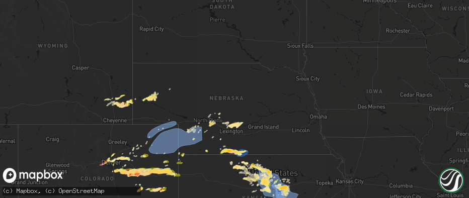
Hail
Wind
5,762
Estimated number of impacted properties by a 1.00" hail or larger1,569
Estimated number of impacted properties by a 1.75" hail or larger308
Estimated number of impacted properties by a 2.50" hail or largerStorm reports in Nebraska
Nebraska
| Date | Description |
|---|---|
| 06/08/20265:23 PM CDT | [landspout] received a photo of a landspout via social media. |
| 06/08/20265:10 PM CDT | A local report indicates 1.00 inch wind near Republican City |
| 06/08/20265:09 PM CDT | A local report indicates 69 MPH wind near 3 NNW Alma |
| 06/08/20265:06 PM CDT | A local report indicates 62 MPH wind near 7 SW Alma |
| 06/08/20265:05 PM CDT | Delayed report of an overblown mobile home. Image sent in over social media. |
| 06/08/20264:50 PM CDT | Wind gusts were estimated to be near 60-70 mph...accompanied by nickel size hail. |
| 06/08/20264:43 PM CDT | A local report indicates 67 MPH wind near 7 SSE Stamford |
| 06/08/20264:13 PM CDT | A local report indicates 1.00 inch wind near Beaver City |
| 06/08/20263:58 PM CDT | Quarter to ping pong ball sized hail started around 350pm... Hail grew to around tennis ball size within last few mins. |
| 06/08/202610:14 AM CDT | Report of hail up to quarter size received via facebook. |
| 06/08/202610:12 AM CDT | Report of hail around the size of golf balls received via facebook. |
| 06/08/202610:09 AM CDT | Ground was white with hail. Most were ping pong ball size and smaller a few were golf ball size. |
| 06/08/20269:36 AM CDT | A local report indicates 1.00 inch wind near 8 WSW Eddyville |
| 06/07/20269:57 PM CDT | A local report indicates 58 MPH wind near 3 NNW Hayes Center |
| 06/07/20269:53 PM CDT | A local report indicates 65 MPH wind near 10 SSW Dickens |
| 06/07/20269:45 PM CDT | A local report indicates 72 MPH wind near 11 NNE Wauneta |
| 06/07/20269:25 PM CDT | A local report indicates 58 MPH wind near 7 NNE Imperial |
| 06/07/20269:20 PM CDT | A local report indicates 62 MPH wind near 7 SW Enders |
| 06/07/20268:29 PM CDT | In stratiform region of thunderstorm cluster. |
| 06/07/20268:11 PM CDT | Personal weather station. |
| 06/07/20268:02 PM CDT | Personal weather station. |
| 06/07/20267:57 PM CDT | Personal weather station reported gust in stratiform region to the north of a thunderstorm. |
| 06/07/20267:42 PM CDT | Personal weather station. |
| 06/07/20267:12 PM CDT | Trained spotter report half dollar size hail currently failing. |
All States Impacted by Hail Map on June 8, 2026
Cities Impacted by Hail Map on June 8, 2026
- Wallace, NE
- Arnold, NE
- North Platte, NE
- Madrid, NE
- Stapleton, NE
- Maxwell, NE
- Strang, OK
- Vinita, OK
- Spavinaw, OK
- Elsie, NE
- Grant, NE
- Colcord, OK
- Eucha, OK
- Jay, OK
- Rose, OK
- Kansas, OK
- Brady, NE
- Twin Oaks, OK
- Watts, OK
- Kismet, KS
- Tahlequah, OK
- Locust Grove, OK
- Oaks, OK
- Peggs, OK
- Gothenburg, NE
- Cozad, NE
- Hulbert, OK
- Lexington, NE
- Oconto, NE
- Callaway, NE
- Eddyville, NE
- Noel, MO
- Pineville, MO
- Sumner, NE
- Rocky Comfort, MO
- Miller, NE
- Exeter, MO
- Washburn, MO
- Pleasanton, NE
- Amherst, NE
- Mason City, NE
- Seligman, MO
- Wauneta, NE
- Sutherland, NE
- Hayes Center, NE
- Maywood, NE
- Curtis, NE
- Wheatland, WY
- Wilsonville, NE
- Eustis, NE
- Moorefield, NE
- Lebanon, NE
- Hendley, NE
- Wellfleet, NE
- Beaver City, NE
- Bartley, NE
- Arapahoe, NE
- Edison, NE
- Yoder, WY
- Holbrook, NE
- Oxford, NE
- Golden, CO
- Wheat Ridge, CO
- Arvada, CO
- Rush, CO
- Cambridge, NE
- Culbertson, NE
- Orleans, NE
- Stamford, NE
- Broomfield, CO
- Hugo, CO
- Sedalia, CO
- Matheson, CO
- Denver, CO
- Englewood, CO
- Castle Rock, CO
- Parker, CO
- Commerce City, CO
- Booker, TX
- Ramah, CO
- Evergreen, CO
- Alma, NE
- Westminster, CO
- Long Island, KS
- Franktown, CO
- Levelland, TX
- Portland, AR
- Keyes, OK
- Follett, TX
- Thornton, CO
- Elizabeth, CO
- Republican City, NE
- Phillipsburg, KS
- Naponee, NE
- Parkdale, AR
- Kress, TX
- Goodwell, OK
- Brighton, CO
- Fort Lupton, CO
- Aurora, CO
- Kiowa, CO
- Hudson, CO
- Bennett, CO
- Watkins, CO
- Pecos, TX
- Karval, CO
- Lenora, KS
- Wray, CO
- Idalia, CO
- Saint Francis, KS
- Kit Carson, CO
- Wild Horse, CO
- Strasburg, CO
- Alton, KS
- Gaylord, KS
- Logan, KS
- Stockton, KS
- Bogue, KS
- Chugwater, WY
- Silverton, TX
- Portis, KS
- Downs, KS
- Deer Trail, CO
- Agra, KS
- Bloomington, NE
- Weldona, CO
- Fort Morgan, CO
- Byers, CO
- Glade, KS
- Agate, CO
- Clarendon, TX
- Almena, KS
- Roggen, CO
- Wiggins, CO
- Perryton, TX
- Kirwin, KS
- Kensington, KS
- Bardwell, KY
- Cheyenne, WY
- Cedar, KS
- Canadian, TX
- Wickliffe, KY
- Lubbock, TX
- Arlington, KY
- Cunningham, KY
- Fancy Farm, KY
- Esbon, KS
- Snyder, CO
- Brush, CO
- Hillrose, CO
- Keenesburg, CO
- Bayard, NE
- Minatare, NE
- Woodrow, CO
- Shallowater, TX
- Limon, CO
- Akron, CO
- Veteran, WY
- Gering, NE
- Scottsbluff, NE
- Cawker City, KS
- Glen Elder, KS
- Osborne, KS
- Merino, CO
- Woodston, KS
- Plainville, KS
- Parks, NE
- Haigler, NE
- Genoa, CO
- Arriba, CO
- Natoma, KS
- Angora, NE
- Waldo, KS
- Sterling, CO
- Mankato, KS
- Lagrange, WY
- Tipton, KS
- Beloit, KS
- Hunter, KS
- Ropesville, TX
- Darrouzett, TX
- Simla, CO
- Paradise, KS
- Lebanon, KS
- Hawk Springs, WY
- Sylvan Grove, KS
- Lucas, KS
- Luray, KS
- Meadow, TX
- Otis, CO
- Flagler, CO
- Lyman, NE
- Barnard, KS
- Lincoln, KS
- Dorrance, KS
- New Cambria, KS
- Salina, KS
- Tescott, KS
- Hardesty, OK
- Iliff, CO
- Balko, OK
- Crook, CO
- Minneapolis, KS
- Torrington, WY
- Wilson, KS
- Ellsworth, KS
- Simpson, KS
- Bunker Hill, KS
- Chappell, NE
- Yuma, CO
- Russell, KS
- Hickory, KY
- Mayfield, KY
- Kuttawa, KY
- Symsonia, KY
- Farmington, KY
- Gilbertsville, KY
- Wingo, KY
- Princeton, KY
- Kirksey, KY
- Grand Rivers, KY
- Dexter, KY
- Murray, KY
- Benton, KY
- Eddyville, KY
- Sedalia, KY
- Almo, KY
- Calvert City, KY
- Hardin, KY
- Cadiz, KY
- New Concord, KY
- Glasco, KS
- Delphos, KS
- Lorraine, KS
- Beverly, KS
- Seibert, CO
- Joes, CO
- Carlos, MN
- Miltona, MN
- Eagle Bend, MN
- Bennington, KS
- Amherst, CO
- Eckley, CO
- Paoli, CO
- Julesburg, CO
- Sedgwick, CO
- Haxtun, CO
- Ovid, CO
- Holyoke, CO
- Fleming, CO
- Padroni, CO
- Atwood, CO
- Peetz, CO
- Big Springs, NE
- Lodgepole, NE
- Vona, CO
- Solomon, KS
- Kanopolis, KS
- Stratton, CO
- Dover, TN
- Herndon, KY
- Big Rock, TN
- Bumpus Mills, TN
- Abilene, KS
- Brookville, KS
- Geneseo, KS
- Marquette, KS
- Whiteface, TX
- Lindsborg, KS
- Falun, KS
- Bethune, CO
- Kirk, CO
- Champion, NE
- Benkelman, NE
- Venango, NE
- Imperial, NE
- Burlington, CO
- Assaria, KS
- Gypsum, KS
- Alliance, NE
- Longford, KS
- Galva, KS
- Mcpherson, KS
- Hope, KS
- Roxbury, KS
- Durham, KS
- Canton, KS
- Tampa, KS
- Enders, NE
- Lehigh, KS
- Ellsworth, NE
- Little River, KS
- Lyons, KS
- Ramona, KS
- Herington, KS
- Moundridge, KS
- Hillsboro, KS
- Burdick, KS
- Walton, KS
- Lincolnville, KS
- Goessel, KS
- Lost Springs, KS
- Hesston, KS
- North Newton, KS
- Marion, KS
- Newton, KS
- Peabody, KS
- Halstead, KS
- Palisade, NE
- Dickens, NE
- Kanorado, KS
- Wakefield, KS
- Bridgeport, NE
- Goodland, KS
- Chapman, KS
- Woodbine, KS
- Enterprise, KS
- Junction City, KS
- White City, KS
- Whitewater, KS
- Sedgwick, KS
- Valley Center, KS
- Florence, KS
- Wichita, KS
- Benton, KS
- Elbing, KS
- Hershey, NE
- Windom, KS
- Manhattan, KS
- Riley, KS
- Talmage, KS
- Miltonvale, KS
- Clay Center, KS
- Fort Riley, KS
- Milford, KS
- Dwight, KS
- Ogden, KS
- Saint George, KS
- Alta Vista, KS
- Alma, KS
- Wamego, KS
- Greenwich, KS
- Kechi, KS
- Potwin, KS
- Cedar Point, KS
- Burns, KS
- Elmdale, KS
- Council Grove, KS
- Cottonwood Falls, KS
- Wilsey, KS
- Strong City, KS
- Edson, KS
- Towanda, KS
- Rose Hill, KS
- Leon, KS
- Cassoday, KS
- Augusta, KS
- Matfield Green, KS
- Emporia, KS
- Derby, KS
- Douglass, KS
- Rosalia, KS
- El Dorado, KS
- Andover, KS
- Americus, KS
- Allen, KS
- McFarland, KS
- Eskridge, KS
- Paxico, KS
- Belvue, KS
- Maple Hill, KS
- Saint Marys, KS
- Admire, KS
- Reading, KS
- Eureka, KS
- Olpe, KS
- Brewster, KS
- Rossville, KS
- Topeka, KS
- Wakarusa, KS
- Burlingame, KS
- Auburn, KS
- Harveyville, KS
- Carbondale, KS
- Vernon, CO
- Scranton, KS
- Osage City, KS
- Neosho Rapids, KS
- Hartford, KS
- Hamilton, KS
- Madison, KS
- Beaumont, KS
- Latham, KS
- Piedmont, KS
- Silver Lake, KS
- Lebo, KS
- Levant, KS
- Lyndon, KS
- Berryton, KS
- Vassar, KS
- Quenemo, KS
- Waverly, KS
- Burlington, KS
- Melvern, KS
- Neosho Falls, KS
- Virgil, KS
- Severy, KS
- Toronto, KS
- Yates Center, KS
- Le Roy, KS
- Gridley, KS
- Neal, KS
- Delia, KS
- Tecumseh, KS
- Meriden, KS
- Overbrook, KS
- Grantville, KS
- Fall River, KS
- Piqua, KS
- Westphalia, KS
- Oskaloosa, KS
- Perry, KS
- Lecompton, KS
- Ozawkie, KS
- Pomona, KS
- Lawrence, KS
- Ottawa, KS
- McLouth, KS
- Tonganoxie, KS
- Williamsburg, KS
- Baldwin City, KS
- De Soto, KS
- Gardner, KS
- Eudora, KS
- Wellsville, KS
- Olathe, KS
- Basehor, KS
- Welda, KS
- Richmond, KS
- Bonner Springs, KS
- Rantoul, KS
- Edgerton, KS
- Linwood, KS
- Colony, KS
- Garnett, KS
- Kansas City, KS
- Princeton, KS
- Lenexa, KS
- Shawnee, KS
- Paola, KS
- Spring Hill, KS
- Centerville, KS
- La Cygne, KS
- Mound City, KS
- Lane, KS
- Blue Mound, KS
- Greeley, KS
- Fontana, KS
- Osawatomie, KS
- New Century, KS
- Parker, KS
- Kincaid, KS
- Ellis, KS
- Mission, KS
- Louisburg, KS
- Stilwell, KS
- Overland Park, KS
- Prairie Village, KS
- Bucyrus, KS
- Leawood, KS
- Belton, MO
- Kansas City, MO
- Cleveland, MO
- Drexel, MO
- Pleasanton, KS
- Grandview, MO
- Peculiar, MO
- Freeman, MO
- Amsterdam, MO
- Adrian, MO
- Butler, MO
- Archie, MO
- Lees Summit, MO
- Raymore, MO
- Greenwood, MO
- Pleasant Hill, MO
- Harrisonville, MO
- La Harpe, KS
- Iola, KS
- Humboldt, KS
- Hays, KS
- Erie, KS
- Savonburg, KS
- Elsmore, KS
- Moran, KS
- Victoria, KS
- Uniontown, KS
- Gorham, KS
- Strasburg, MO
- East Lynne, MO
- Holden, MO
- Warrensburg, MO
- Chilhowee, MO
- Garden City, MO
- Creighton, MO
- Lone Jack, MO
- Grain Valley, MO
- Clinton, MO
- Urich, MO
- Leeton, MO
- Kingsville, MO
- Blairstown, MO
- Centerview, MO
- Calhoun, MO
- Jewell, KS
- Randall, KS
- Windsor, MO
- Knob Noster, MO
- Jamestown, KS
- New Raymer, CO
- Concordia, KS
- Aurora, KS
- Osceola, MO
- Lowry City, MO
- Collins, MO
- Briggsdale, CO
- Leonardville, KS
- Stoneham, CO
- Detroit Lakes, MN
- Penokee, KS
- Grover, CO
- Olsburg, KS
- Westmoreland, KS
- Bronson, KS
- Sidney, NE
- Winger, MN
- Bejou, MN
- Fertile, MN
- Ponemah, MN
- Brookport, IL
- Golconda, IL
- Lone Tree, CO
- Boaz, KY
- Paducah, KY


