Hail Map in Colorado on June 8, 2026
The weather event in Colorado on June 8, 2026 includes Hail and Wind maps. 12 states and 544 cities were impacted and suffered possible damage. The total estimated number of properties impacted is 98,435.
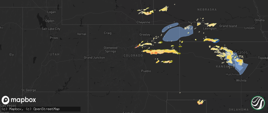
Hail
Wind
98,435
Estimated number of impacted properties by a 1.00" hail or larger27,462
Estimated number of impacted properties by a 1.75" hail or larger1,389
Estimated number of impacted properties by a 2.50" hail or largerStorm reports in Colorado
Colorado
| Date | Description |
|---|---|
| 06/08/20266:56 PM CDT | A local report indicates 3.40 inch wind near 4 SSW Cedar Point |
| 06/08/20266:31 PM CDT | A local report indicates 2.00 inch wind near 9 NW Matheson |
| 06/08/20266:27 PM CDT | Trained spotter report of ping pong ball sized hail. |
| 06/08/20266:26 PM CDT | Report from mping: ping pong ball |
| 06/08/20266:24 PM CDT | Social media report via picture various hail stones roughly ping pong ball size and smaller. |
| 06/08/20266:19 PM CDT | A local report indicates 2.75 inch wind near 13 NNW Simla |
| 06/08/20265:37 PM CDT | A local report indicates 1.75 inch wind near 7 N Manila Village |
| 06/08/20265:22 PM CDT | Report from mping: quarter |
| 06/08/20265:15 PM CDT | A local report indicates 1.25 inch wind near 7 S Boyero |
| 06/08/20265:15 PM CDT | A local report indicates 1.25 inch wind near 4 W The Pinery |
| 06/08/20265:12 PM CDT | Asos station kden denver intl airport. |
| 06/08/20265:10 PM CDT | A local report indicates 1.25 inch wind near 1 WSW Fort Lupton |
| 06/08/20264:56 PM CDT | A local report indicates 1.00 inch wind near 1 WSW Golden |
| 06/08/20264:45 PM CDT | A local report indicates 2.20 inch wind near 1 E Punkin Center |
| 06/08/20264:43 PM CDT | A local report indicates 1.50 inch wind near 3 S Punkin Center |
| 06/08/20264:41 PM CDT | A local report indicates 1.50 inch wind near 1 W The Pinery |
| 06/08/20264:40 PM CDT | Report from mping: quarter |
| 06/08/20264:35 PM CDT | A local report indicates 2.00 inch wind near 2 S Punkin Center |
| 06/08/20264:34 PM CDT | Time estimated by radar. |
| 06/08/20264:32 PM CDT | A local report indicates 1.00 inch wind near 2 N Lakewood |
| 06/08/20264:31 PM CDT | A local report indicates 1.00 inch wind near 3 NE Castle Pines |
| 06/08/20264:30 PM CDT | A local report indicates 1.00 inch wind near 2 ENE Bergen Park |
| 06/08/20264:30 PM CDT | A local report indicates 1.50 inch wind near 2 E Arvada |
| 06/08/20264:30 PM CDT | A local report indicates 1.75 inch wind near Wah Keeney Park |
| 06/08/20264:27 PM CDT | A local report indicates 1.00 inch wind near 1 W Wheat Ridge |
| 06/08/20264:26 PM CDT | A local report indicates 1.00 inch wind near 1 N Wheat Ridge |
| 06/08/20264:25 PM CDT | A local report indicates 1.50 inch wind near 2 S Punkin Center |
| 06/08/20264:24 PM CDT | Report from mping: quarter |
| 06/08/20264:22 PM CDT | Mesonet station co001 i-25 and c470. |
| 06/08/20264:20 PM CDT | A local report indicates 1.00 inch wind near 1 S Punkin Center |
| 06/08/20264:16 PM CDT | A local report indicates 1.00 inch wind near 2 W Wheat Ridge |
| 06/08/20264:15 PM CDT | A local report indicates 1.25 inch wind near 3 W Wheat Ridge |
| 06/08/20264:14 PM CDT | Time and location estimated by radar. |
| 06/08/20264:09 PM CDT | Report from mping: quarter |
| 06/08/20264:03 PM CDT | Time estimated by radar. |
| 06/08/20261:10 AM CDT | Delayed report from mping: tea cup |
| 06/08/20261:05 AM CDT | Delayed report from mping: tea cup |
| 06/08/202612:49 AM CDT | Twitter report with image of 3 inch hail measured with a ruler. Time estimated from radar. |
| 06/08/202612:47 AM CDT | Mping report; time estimated from radar. |
| 06/07/202611:51 PM CDT | Mesonet station co047 385n220 idalia. |
| 06/07/202611:51 PM CDT | Twitter report: lots of quarter and ping pong sized hail. Time and location estimated from radar. |
| 06/07/202610:45 PM CDT | Personal weather station. |
| 06/07/202610:44 PM CDT | A local report indicates 2.00 inch wind near 4 SSE Hugo |
| 06/07/20269:40 PM CDT | Social media report |
| 06/07/20269:12 PM CDT | Report from mping: golf ball |
| 06/07/20268:59 PM CDT | Mping report; time estimated from radar. |
| 06/07/20268:51 PM CDT | Personal weather station. |
| 06/07/20268:41 PM CDT | Mesonet station up469 2.3 ne ovid |
| 06/07/20268:38 PM CDT | Hail stones measured with a ruler along hwy 59... Most stones dime sized. Time estimated from radar. Report about 20-25 minutes after estimated time. |
| 06/07/20268:33 PM CDT | A local report indicates 73 MPH wind near 3 WSW Julesburg |
| 06/07/20268:31 PM CDT | Dime to quarter sized hail on the ground on the ground along hwy 59; time estimated from radar... Reported about 20-25 mins after estimated time. |
| 06/07/20268:17 PM CDT | Public report 6 n flagler. |
| 06/07/20268:01 PM CDT | Noaa mobile mesonet. Report relayed via spotternetwork. |
| 06/07/20268:00 PM CDT | A local report indicates 67 MPH wind near 1 N St Petersburg |
| 06/07/20267:57 PM CDT | Personal weather station. |
| 06/07/20267:50 PM CDT | A local report indicates 72 MPH wind near 4 SW Fleming |
| 06/07/20267:35 PM CDT | Awos station kstk sterling. |
| 06/07/20267:22 PM CDT | Report from mping: quarter |
| 06/07/20267:15 PM CDT | Personal weather station. |
| 06/07/20267:12 PM CDT | Report from mping: quarter |
All States Impacted by Hail Map on June 8, 2026
Cities Impacted by Hail Map on June 8, 2026
- Wallace, NE
- Arnold, NE
- North Platte, NE
- Madrid, NE
- Stapleton, NE
- Maxwell, NE
- Strang, OK
- Vinita, OK
- Spavinaw, OK
- Elsie, NE
- Grant, NE
- Colcord, OK
- Eucha, OK
- Jay, OK
- Rose, OK
- Kansas, OK
- Brady, NE
- Twin Oaks, OK
- Watts, OK
- Kismet, KS
- Tahlequah, OK
- Locust Grove, OK
- Oaks, OK
- Peggs, OK
- Gothenburg, NE
- Cozad, NE
- Hulbert, OK
- Lexington, NE
- Oconto, NE
- Callaway, NE
- Eddyville, NE
- Noel, MO
- Pineville, MO
- Sumner, NE
- Rocky Comfort, MO
- Miller, NE
- Exeter, MO
- Washburn, MO
- Pleasanton, NE
- Amherst, NE
- Mason City, NE
- Seligman, MO
- Wauneta, NE
- Sutherland, NE
- Hayes Center, NE
- Maywood, NE
- Curtis, NE
- Wheatland, WY
- Wilsonville, NE
- Eustis, NE
- Moorefield, NE
- Lebanon, NE
- Hendley, NE
- Wellfleet, NE
- Beaver City, NE
- Bartley, NE
- Arapahoe, NE
- Edison, NE
- Yoder, WY
- Holbrook, NE
- Oxford, NE
- Golden, CO
- Wheat Ridge, CO
- Arvada, CO
- Rush, CO
- Cambridge, NE
- Culbertson, NE
- Orleans, NE
- Stamford, NE
- Broomfield, CO
- Hugo, CO
- Sedalia, CO
- Matheson, CO
- Denver, CO
- Englewood, CO
- Castle Rock, CO
- Parker, CO
- Commerce City, CO
- Booker, TX
- Ramah, CO
- Evergreen, CO
- Alma, NE
- Westminster, CO
- Long Island, KS
- Franktown, CO
- Levelland, TX
- Portland, AR
- Keyes, OK
- Follett, TX
- Thornton, CO
- Elizabeth, CO
- Republican City, NE
- Phillipsburg, KS
- Naponee, NE
- Parkdale, AR
- Kress, TX
- Goodwell, OK
- Brighton, CO
- Fort Lupton, CO
- Aurora, CO
- Kiowa, CO
- Hudson, CO
- Bennett, CO
- Watkins, CO
- Pecos, TX
- Karval, CO
- Lenora, KS
- Wray, CO
- Idalia, CO
- Saint Francis, KS
- Kit Carson, CO
- Wild Horse, CO
- Strasburg, CO
- Alton, KS
- Gaylord, KS
- Logan, KS
- Stockton, KS
- Bogue, KS
- Chugwater, WY
- Silverton, TX
- Portis, KS
- Downs, KS
- Deer Trail, CO
- Agra, KS
- Bloomington, NE
- Weldona, CO
- Fort Morgan, CO
- Byers, CO
- Glade, KS
- Agate, CO
- Clarendon, TX
- Almena, KS
- Roggen, CO
- Wiggins, CO
- Perryton, TX
- Kirwin, KS
- Kensington, KS
- Bardwell, KY
- Cheyenne, WY
- Cedar, KS
- Canadian, TX
- Wickliffe, KY
- Lubbock, TX
- Arlington, KY
- Cunningham, KY
- Fancy Farm, KY
- Esbon, KS
- Snyder, CO
- Brush, CO
- Hillrose, CO
- Keenesburg, CO
- Bayard, NE
- Minatare, NE
- Woodrow, CO
- Shallowater, TX
- Limon, CO
- Akron, CO
- Veteran, WY
- Gering, NE
- Scottsbluff, NE
- Cawker City, KS
- Glen Elder, KS
- Osborne, KS
- Merino, CO
- Woodston, KS
- Plainville, KS
- Parks, NE
- Haigler, NE
- Genoa, CO
- Arriba, CO
- Natoma, KS
- Angora, NE
- Waldo, KS
- Sterling, CO
- Mankato, KS
- Lagrange, WY
- Tipton, KS
- Beloit, KS
- Hunter, KS
- Ropesville, TX
- Darrouzett, TX
- Simla, CO
- Paradise, KS
- Lebanon, KS
- Hawk Springs, WY
- Sylvan Grove, KS
- Lucas, KS
- Luray, KS
- Meadow, TX
- Otis, CO
- Flagler, CO
- Lyman, NE
- Barnard, KS
- Lincoln, KS
- Dorrance, KS
- New Cambria, KS
- Salina, KS
- Tescott, KS
- Hardesty, OK
- Iliff, CO
- Balko, OK
- Crook, CO
- Minneapolis, KS
- Torrington, WY
- Wilson, KS
- Ellsworth, KS
- Simpson, KS
- Bunker Hill, KS
- Chappell, NE
- Yuma, CO
- Russell, KS
- Hickory, KY
- Mayfield, KY
- Kuttawa, KY
- Symsonia, KY
- Farmington, KY
- Gilbertsville, KY
- Wingo, KY
- Princeton, KY
- Kirksey, KY
- Grand Rivers, KY
- Dexter, KY
- Murray, KY
- Benton, KY
- Eddyville, KY
- Sedalia, KY
- Almo, KY
- Calvert City, KY
- Hardin, KY
- Cadiz, KY
- New Concord, KY
- Glasco, KS
- Delphos, KS
- Lorraine, KS
- Beverly, KS
- Seibert, CO
- Joes, CO
- Carlos, MN
- Miltona, MN
- Eagle Bend, MN
- Bennington, KS
- Amherst, CO
- Eckley, CO
- Paoli, CO
- Julesburg, CO
- Sedgwick, CO
- Haxtun, CO
- Ovid, CO
- Holyoke, CO
- Fleming, CO
- Padroni, CO
- Atwood, CO
- Peetz, CO
- Big Springs, NE
- Lodgepole, NE
- Vona, CO
- Solomon, KS
- Kanopolis, KS
- Stratton, CO
- Dover, TN
- Herndon, KY
- Big Rock, TN
- Bumpus Mills, TN
- Abilene, KS
- Brookville, KS
- Geneseo, KS
- Marquette, KS
- Whiteface, TX
- Lindsborg, KS
- Falun, KS
- Bethune, CO
- Kirk, CO
- Champion, NE
- Benkelman, NE
- Venango, NE
- Imperial, NE
- Burlington, CO
- Assaria, KS
- Gypsum, KS
- Alliance, NE
- Longford, KS
- Galva, KS
- Mcpherson, KS
- Hope, KS
- Roxbury, KS
- Durham, KS
- Canton, KS
- Tampa, KS
- Enders, NE
- Lehigh, KS
- Ellsworth, NE
- Little River, KS
- Lyons, KS
- Ramona, KS
- Herington, KS
- Moundridge, KS
- Hillsboro, KS
- Burdick, KS
- Walton, KS
- Lincolnville, KS
- Goessel, KS
- Lost Springs, KS
- Hesston, KS
- North Newton, KS
- Marion, KS
- Newton, KS
- Peabody, KS
- Halstead, KS
- Palisade, NE
- Dickens, NE
- Kanorado, KS
- Wakefield, KS
- Bridgeport, NE
- Goodland, KS
- Chapman, KS
- Woodbine, KS
- Enterprise, KS
- Junction City, KS
- White City, KS
- Whitewater, KS
- Sedgwick, KS
- Valley Center, KS
- Florence, KS
- Wichita, KS
- Benton, KS
- Elbing, KS
- Hershey, NE
- Windom, KS
- Manhattan, KS
- Riley, KS
- Talmage, KS
- Miltonvale, KS
- Clay Center, KS
- Fort Riley, KS
- Milford, KS
- Dwight, KS
- Ogden, KS
- Saint George, KS
- Alta Vista, KS
- Alma, KS
- Wamego, KS
- Greenwich, KS
- Kechi, KS
- Potwin, KS
- Cedar Point, KS
- Burns, KS
- Elmdale, KS
- Council Grove, KS
- Cottonwood Falls, KS
- Wilsey, KS
- Strong City, KS
- Edson, KS
- Towanda, KS
- Rose Hill, KS
- Leon, KS
- Cassoday, KS
- Augusta, KS
- Matfield Green, KS
- Emporia, KS
- Derby, KS
- Douglass, KS
- Rosalia, KS
- El Dorado, KS
- Andover, KS
- Americus, KS
- Allen, KS
- McFarland, KS
- Eskridge, KS
- Paxico, KS
- Belvue, KS
- Maple Hill, KS
- Saint Marys, KS
- Admire, KS
- Reading, KS
- Eureka, KS
- Olpe, KS
- Brewster, KS
- Rossville, KS
- Topeka, KS
- Wakarusa, KS
- Burlingame, KS
- Auburn, KS
- Harveyville, KS
- Carbondale, KS
- Vernon, CO
- Scranton, KS
- Osage City, KS
- Neosho Rapids, KS
- Hartford, KS
- Hamilton, KS
- Madison, KS
- Beaumont, KS
- Latham, KS
- Piedmont, KS
- Silver Lake, KS
- Lebo, KS
- Levant, KS
- Lyndon, KS
- Berryton, KS
- Vassar, KS
- Quenemo, KS
- Waverly, KS
- Burlington, KS
- Melvern, KS
- Neosho Falls, KS
- Virgil, KS
- Severy, KS
- Toronto, KS
- Yates Center, KS
- Le Roy, KS
- Gridley, KS
- Neal, KS
- Delia, KS
- Tecumseh, KS
- Meriden, KS
- Overbrook, KS
- Grantville, KS
- Fall River, KS
- Piqua, KS
- Westphalia, KS
- Oskaloosa, KS
- Perry, KS
- Lecompton, KS
- Ozawkie, KS
- Pomona, KS
- Lawrence, KS
- Ottawa, KS
- McLouth, KS
- Tonganoxie, KS
- Williamsburg, KS
- Baldwin City, KS
- De Soto, KS
- Gardner, KS
- Eudora, KS
- Wellsville, KS
- Olathe, KS
- Basehor, KS
- Welda, KS
- Richmond, KS
- Bonner Springs, KS
- Rantoul, KS
- Edgerton, KS
- Linwood, KS
- Colony, KS
- Garnett, KS
- Kansas City, KS
- Princeton, KS
- Lenexa, KS
- Shawnee, KS
- Paola, KS
- Spring Hill, KS
- Centerville, KS
- La Cygne, KS
- Mound City, KS
- Lane, KS
- Blue Mound, KS
- Greeley, KS
- Fontana, KS
- Osawatomie, KS
- New Century, KS
- Parker, KS
- Kincaid, KS
- Ellis, KS
- Mission, KS
- Louisburg, KS
- Stilwell, KS
- Overland Park, KS
- Prairie Village, KS
- Bucyrus, KS
- Leawood, KS
- Belton, MO
- Kansas City, MO
- Cleveland, MO
- Drexel, MO
- Pleasanton, KS
- Grandview, MO
- Peculiar, MO
- Freeman, MO
- Amsterdam, MO
- Adrian, MO
- Butler, MO
- Archie, MO
- Lees Summit, MO
- Raymore, MO
- Greenwood, MO
- Pleasant Hill, MO
- Harrisonville, MO
- La Harpe, KS
- Iola, KS
- Humboldt, KS
- Hays, KS
- Erie, KS
- Savonburg, KS
- Elsmore, KS
- Moran, KS
- Victoria, KS
- Uniontown, KS
- Gorham, KS
- Strasburg, MO
- East Lynne, MO
- Holden, MO
- Warrensburg, MO
- Chilhowee, MO
- Garden City, MO
- Creighton, MO
- Lone Jack, MO
- Grain Valley, MO
- Clinton, MO
- Urich, MO
- Leeton, MO
- Kingsville, MO
- Blairstown, MO
- Centerview, MO
- Calhoun, MO
- Jewell, KS
- Randall, KS
- Windsor, MO
- Knob Noster, MO
- Jamestown, KS
- New Raymer, CO
- Concordia, KS
- Aurora, KS
- Osceola, MO
- Lowry City, MO
- Collins, MO
- Briggsdale, CO
- Leonardville, KS
- Stoneham, CO
- Detroit Lakes, MN
- Penokee, KS
- Grover, CO
- Olsburg, KS
- Westmoreland, KS
- Bronson, KS
- Sidney, NE
- Winger, MN
- Bejou, MN
- Fertile, MN
- Ponemah, MN
- Brookport, IL
- Golconda, IL
- Lone Tree, CO
- Boaz, KY
- Paducah, KY


