Hail Map in North Dakota on June 9, 2026
The weather event in North Dakota on June 9, 2026 includes Tornado, Hail, and Wind maps. 22 states and 1,173 cities were impacted and suffered possible damage. The total estimated number of properties impacted is 14,435.
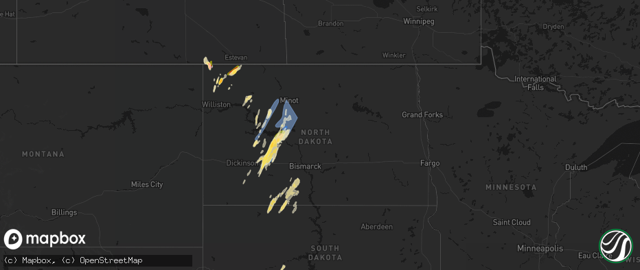
Tornado
Hail
Wind
14,435
Estimated number of impacted properties by a 1.00" hail or larger825
Estimated number of impacted properties by a 1.75" hail or larger50
Estimated number of impacted properties by a 2.50" hail or largerStorm reports in North Dakota
North Dakota
| Date | Description |
|---|---|
| 06/09/20266:49 PM CDT | Social media reports of downed tree branches in minot from strong winds. |
| 06/09/20266:49 PM CDT | 72mph 10m gust measured at 7s sawyer ndawn. |
| 06/09/20266:48 PM CDT | 60mph at 10m 4s minot ndawn. |
| 06/09/20266:45 PM CDT | 2 in reported near alamo from williams county em. |
| 06/09/20266:40 PM CDT | Emergency manger reported 3 inch hail 6:40pm in fortuna. |
| 06/09/20266:36 PM CDT | Mostly smaller hail... But a few as large as golf balls. |
| 06/09/20266:29 PM CDT | Awos station k1dn 1 s max. |
| 06/09/20266:19 PM CDT | Em called and report sheets of rain and pea size hail and 60 mph winds. |
| 06/09/20266:16 PM CDT | A local report indicates 75 MPH wind near 3 SSE Garrison |
| 06/09/20266:13 PM CDT | 58mph gust 13nw garrison ndawn. |
| 06/09/20266:11 PM CDT | Measured wind gust on private weather station. |
| 06/09/20266:03 PM CDT | Quarter-inch hail reported by williams county em. |
| 06/09/20265:42 PM CDT | 62mph at 10m at 5n halliday ndawn. |
| 06/09/20265:35 PM CDT | A local report indicates 1.50 inch wind near Beulah |
| 06/09/20265:30 PM CDT | Social media report of quarter size hail at 530 pm in beulah. |
| 06/09/20265:16 PM CDT | Quarter-sized measured from bottle cap in beulah. |
| 06/09/20265:16 PM CDT | Broadcast media reported golf ball size hail in richardton. |
| 06/09/20265:15 PM CDT | Quarter-inch hail reported in beulah at 5:15 from social media. |
| 06/09/20265:10 PM CDT | Half-dollar sized hail. |
| 06/09/20265:02 PM CDT | A local report indicates 1.00 inch wind near Hebron |
| 06/09/20265:00 PM CDT | Corrects previous report for the city of richardton. Broadcast media relayed report of golf ball sized hail. Started as marble size before increasing in size... And las |
| 06/09/20264:57 PM CDT | 59mph at 10m hebron 7s ndawn. |
| 06/09/202611:23 AM CDT | 10 m wind gust at ndawn site streeter 6 nw. |
| 06/09/20261:43 AM CDT | A local report indicates 60 MPH wind near 3 NNW Fargo |
| 06/09/20261:10 AM CDT | Ndawn site reporting at 10 ft. |
| 06/09/20261:06 AM CDT | Ndawn site reporting at 33 ft. |
| 06/09/20261:05 AM CDT | A local report indicates 59 MPH wind near 3 N Mcleod |
| 06/09/202612:42 AM CDT | Weather underground station report. |
| 06/09/202612:29 AM CDT | Weather underground station report. |
| 06/09/202612:15 AM CDT | Several large branches down - branches are about the size of a baseball bat in diameter. |
| 06/09/202612:07 AM CDT | 6 inch in diameter tree branch broken. Radar estimated time. Report relayed via social media. |
| 06/09/202612:01 AM CDT | 10 m wind gust at ndawn site marion 2 s. |
| 06/08/202611:53 PM CDT | Quarter size hail falling at time of report. Power outage also reported. |
| 06/08/202611:51 PM CDT | Asos station kjms jamestown airport. |
| 06/08/202611:40 PM CDT | Several large cottonwood trees down... Structural damage to house including gutter... Siding... And sofitt. |
| 06/08/202611:35 PM CDT | 10 m gust at ndawn station ellendale 4 ne. Gusts of this magnitude lasted for 10 minutes. |
| 06/08/202611:23 PM CDT | Corrects time of previous tstm wnd gst report from 7 nw streeter. 10 m wind gust at ndawn site streeter 6 nw. |
| 06/08/202611:10 PM CDT | Several large trees down - all laying to the northeast. |
| 06/08/202610:19 PM CDT | A local report indicates 58 MPH wind near 3 W Devils Lake |
| 06/08/202610:17 PM CDT | Corrects previous tstm wnd gst report from 1 n webster. Ndawn site reporting at 33 ft. |
| 06/08/20269:50 PM CDT | Gust at 10 ft. |
| 06/08/20269:41 PM CDT | Ndawn site at 33 ft. |
| 06/08/20269:34 PM CDT | Personal weather station. |
| 06/08/20269:30 PM CDT | Public report of 1nw of fessenden of estimated 60 mph. |
| 06/08/20269:19 PM CDT | Storm chasers reported 60 mph winds. |
| 06/08/20269:16 PM CDT | Awos station k5h4 harvey nd awos. Time estimated from radar. |
| 06/08/20268:47 PM CDT | Mesonet station ts633 long lake nwr. |
| 06/08/20268:42 PM CDT | 60mph at 10m... 5nw steele ndawn. |
| 06/08/20268:17 PM CDT | 63mph gust recorded at 3m at 1n bowbells ndawn. |
| 06/08/20267:59 PM CDT | Measured wind gust at private weather station. |
| 06/08/20267:53 PM CDT | 58mph gust recorded at 3m at ndawn 1se portal. |
| 06/08/20267:49 PM CDT | Measured wind gust at westhope nddot site. Time estimated from radar. |
| 06/08/20267:46 PM CDT | Mesonet station jcsn8 j. Clark salyer. |
| 06/08/20267:38 PM CDT | 62mph gust recorded at 3m ndawn 14w of bottineau. |
| 06/08/20267:25 PM CDT | Report from emergency manager of ping pong ball sized hail. |
| 06/08/20267:25 PM CDT | Photos relayed from fire department of damage to a homestead. Main area of damage is to a barn on the property... With roof panels ripped off and some collapse of wood |
| 06/08/20267:21 PM CDT | Tornado reported via social media by a storm chaser at 7:21 pm. |
| 06/08/20267:19 PM CDT | 68mph gust reported from 3sw bantry ndawn at 10m. |
| 06/08/20267:14 PM CDT | Delayed media report of golf ball size 6 south of noonan. |
| 06/08/20267:03 PM CDT | Spotter estimated winds of 60 to 70 mph as gust front moved into velva. |
| 06/08/20267:01 PM CDT | 59mph gust recorded at 3m at 3s genoa ndawn. |
| 06/08/20267:00 PM CDT | Ward county emergency manager relayed damage reports from the town of sawyer. Power was out... Numerous trees down on roads... And a large tree fell onto a house and ma |
All States Impacted by Hail Map on June 9, 2026
Cities Impacted by Hail Map on June 9, 2026
- La Harpe, KS
- Wildrose, ND
- Ray, ND
- Tioga, ND
- Mcgregor, ND
- Plymouth, IL
- Colchester, IL
- Industry, IL
- Macomb, IL
- Bardwell, KY
- Freeland, MI
- Wickliffe, KY
- Paris, TN
- Gleason, TN
- Springville, TN
- Springfield, TN
- Greenbrier, TN
- Puryear, TN
- Cottage Grove, TN
- Neelyville, MO
- Southgate, MI
- Wyandotte, MI
- White House, TN
- McKenzie, TN
- Arlington, KY
- Concord, GA
- Cross Plains, TN
- Fancy Farm, KY
- Mayfield, KY
- Williamson, GA
- Tiptonville, TN
- Goodlettsville, TN
- Franklin, KY
- Big Sandy, TN
- Luverne, AL
- Hendersonville, TN
- Cottontown, TN
- Wingo, KY
- Auburn, KY
- Russellville, KY
- Cumberland City, TN
- Erin, TN
- Morgantown, KY
- Sedalia, KY
- Beaver Dam, KY
- Farmington, KY
- Indian Mound, TN
- Oakland, KY
- Bowling Green, KY
- Santa Rosa, NM
- Murray, KY
- Kirksey, KY
- Palmyra, TN
- Pueblo, CO
- Clarksville, TN
- Woodlawn, TN
- Henry, TN
- Greenville, AL
- Cheyenne Wells, CO
- Conchas Dam, NM
- Garita, NM
- Boone, CO
- Arapahoe, CO
- Ulysses, KS
- Trementina, NM
- Satanta, KS
- Cuervo, NM
- Chapmansboro, TN
- Cedar Hill, TN
- Lineville, AL
- Guthrie, KY
- Trenton, KY
- Elkton, KY
- Moscow, KS
- Pleasant View, TN
- Ashland City, TN
- Adams, TN
- Joelton, TN
- Trenton, UT
- Adairville, KY
- Olmstead, KY
- Richardton, ND
- Garden City, KS
- Felt, OK
- Allensville, KY
- Mosquero, NM
- Clarkston, UT
- Cornish, UT
- Hebron, ND
- Beulah, ND
- New England, ND
- Richmond, UT
- Dighton, KS
- Dresden, TN
- Sterling, CO
- Healy, KS
- Zap, ND
- Cimarron, KS
- Sublette, KS
- Hugoton, KS
- Edgemont, SD
- Johnson, KS
- Sidney, NE
- Lemmon, SD
- Old Hickory, TN
- Hermitage, TN
- Madison, TN
- Nashville, TN
- Mount Juliet, TN
- Williston, ND
- Mott, ND
- Zahl, ND
- Lefor, ND
- Regent, ND
- Antioch, TN
- Smyrna, TN
- La Vergne, TN
- Lebanon, TN
- Murfreesboro, TN
- Ingalls, KS
- Montezuma, KS
- Copeland, KS
- Beeler, KS
- Taylor, ND
- Utica, KS
- Keldron, SD
- Alamo, ND
- Richfield, KS
- Charleston, IL
- Goodland, KS
- Edson, KS
- Brewster, KS
- Colby, KS
- McDonald, KS
- Lascassas, TN
- Watertown, TN
- Milton, TN
- Oberlin, KS
- Elgin, ND
- Ashmore, IL
- Selfridge, ND
- Arnold, KS
- Ransom, KS
- Scott City, KS
- West Lafayette, IN
- Otterbein, IN
- Readyville, TN
- Christiana, TN
- Auburntown, TN
- Woodbury, TN
- Penokee, KS
- Morland, KS
- Hazen, ND
- Glen Ullin, ND
- Westpoint, IN
- Macedonia, IL
- McLeansboro, IL
- New Leipzig, ND
- Paris, IL
- Lafayette, IN
- Bradyville, TN
- Beechgrove, TN
- Ensign, KS
- Dodge City, KS
- Jetmore, KS
- Lenora, KS
- Kansas, IL
- Hill City, KS
- Hemingford, NE
- Marsland, NE
- Halliday, ND
- Manchester, TN
- Morrison, TN
- Stanton, ND
- Prairie View, KS
- Logan, KS
- Almena, KS
- Wheatfield, IN
- Oshkosh, NE
- Golden Valley, ND
- Killdeer, ND
- Toledo, IL
- Greenup, IL
- Bogue, KS
- Roseglen, ND
- Lafayette, AL
- Norton, KS
- Brownell, KS
- Phillipsburg, KS
- Underwood, ND
- Riverdale, ND
- Coleharbor, ND
- Garrison, ND
- Alexander, KS
- Rush Center, KS
- Nekoma, KS
- La Crosse, KS
- Long Island, KS
- Douglas, ND
- Ryder, ND
- Max, ND
- Carson, ND
- Fortuna, ND
- Casey, IL
- Martinsville, IL
- Hanston, KS
- Burdett, KS
- Plaza, ND
- Marshall, IL
- Parshall, ND
- Dodge, ND
- Beaver City, NE
- Orleans, NE
- Stamford, NE
- Alma, NE
- Bison, KS
- Oxford, NE
- Channing, TX
- Adrian, TX
- Hartley, TX
- Watauga, SD
- Brownsburg, IN
- Danville, IN
- Pittsboro, IN
- McIntosh, SD
- Makoti, ND
- Larned, KS
- Minot, ND
- Lewellen, NE
- Big Springs, NE
- Dennison, IL
- Ellis, KS
- Hays, KS
- Atlanta, NE
- Holdrege, NE
- Republican City, NE
- Des Lacs, ND
- Berthold, ND
- Crosby, ND
- Raleigh, ND
- Shields, ND
- Rozel, KS
- West Terre Haute, IN
- Bloomingdale, IN
- Ambrose, ND
- Noonan, ND
- Terre Haute, IN
- Brazil, IN
- Staunton, IN
- Centerpoint, IN
- Knightsville, IN
- Hildreth, NE
- West Union, IL
- Axtell, NE
- Wilcox, NE
- Otis, KS
- Philip, SD
- Midland, SD
- Arthur, NE
- Lemoyne, NE
- Funk, NE
- Naponee, NE
- Henagar, AL
- Victoria, KS
- Catharine, KS
- Plainville, KS
- Columbus, ND
- Kearney, NE
- Elm Creek, NE
- Riverdale, NE
- Upland, NE
- Minden, NE
- Campbell, NE
- Odessa, NE
- Heartwell, NE
- Flasher, ND
- Farmersburg, IN
- Milesville, SD
- Ross, ND
- Stanley, ND
- Grenora, ND
- Shelburn, IN
- New Town, ND
- Pleasanton, NE
- Gibbon, NE
- Holstein, NE
- Kenesaw, NE
- Juniata, NE
- Shelton, NE
- Roseland, NE
- Bladen, NE
- Merriman, NE
- Gordon, NE
- Ellsworth, NE
- Pawnee Rock, KS
- Solen, ND
- Kingston, GA
- Plains, KS
- Reelsville, IN
- Cartersville, GA
- McLaughlin, SD
- Fairbanks, IN
- Greencastle, IN
- Jasonville, IN
- Lewis, IN
- Plentywood, MT
- Walker, SD
- Wood River, NE
- Doniphan, NE
- Wright, KS
- Spearville, KS
- Great Bend, KS
- Hudson, KS
- Ellinwood, KS
- St John, KS
- Claflin, KS
- Raymond, KS
- Hastings, NE
- Benedict, ND
- Ruso, ND
- Sawyer, ND
- Trumbull, NE
- Alda, NE
- Granville, ND
- Norwich, ND
- Velva, ND
- Palermo, ND
- Sullivan, IN
- Merom, IN
- Sutherland, NE
- Tryon, NE
- Antelope, MT
- Portal, ND
- Clay City, IN
- Wanblee, SD
- Saint Anthony, ND
- North Platte, NE
- Bowling Green, IN
- Glenburn, ND
- Surrey, ND
- Bantry, ND
- Deering, ND
- Upham, ND
- Westhope, ND
- Newburg, ND
- Lansford, ND
- Maxbass, ND
- Souris, ND
- Kramer, ND
- Towner, ND
- Mcclusky, ND
- Fort Pierre, SD
- Hayes, SD
- Fort Yates, ND
- Willow City, ND
- Kenmare, ND
- Donnybrook, ND
- Wakpala, SD
- Drake, ND
- Minneola, KS
- Coalmont, IN
- Hymera, IN
- Mullen, NE
- Grand Island, NE
- Phillips, NE
- Giltner, NE
- Aurora, NE
- Hampton, NE
- Marquette, NE
- Chapman, NE
- Hordville, NE
- Central City, NE
- Gladstone, ND
- Polk, NE
- Powers Lake, ND
- Beloit, KS
- Clarks, NE
- Scotia, NE
- Wolbach, NE
- Rugby, ND
- Worthington, IN
- Coal City, IN
- Ansley, NE
- Mason City, NE
- Saint Paul, NE
- Stapleton, NE
- Cedar Rapids, NE
- Westerville, NE
- Arcadia, NE
- Comstock, NE
- Ord, NE
- Ford, KS
- Bushton, KS
- Chase, KS
- Stromsburg, NE
- Indianapolis, IN
- Pendleton, IN
- Mccordsville, IN
- Fortville, IN
- Greenfield, IN
- Broken Bow, NE
- Lignite, ND
- Strasburg, ND
- Cory, IN
- Greeley, NE
- Denhoff, ND
- Goodrich, ND
- Saint Francis, SD
- Linton, ND
- Moffit, ND
- Hazelton, ND
- Bowbells, ND
- Flaxton, ND
- Osceola, NE
- Seneca, NE
- Thedford, NE
- Arnold, NE
- Halsey, NE
- Dunning, NE
- Driscoll, ND
- Wing, ND
- Fullerton, NE
- Martin, ND
- Spalding, NE
- Broadus, MT
- Alzada, MT
- Linton, IN
- Lyons, IN
- Pierre, SD
- Elyria, NE
- Bradshaw, NE
- York, NE
- Shelby, NE
- Benedict, NE
- Ulysses, NE
- Rising City, NE
- Gresham, NE
- Waco, NE
- Surprise, NE
- Balta, ND
- Sargent, NE
- Harvey, ND
- Battle Creek, NE
- Pollock, SD
- Belcourt, ND
- Burwell, NE
- Vivian, SD
- Rolette, ND
- Switz City, IN
- Presho, SD
- Purdum, NE
- David City, NE
- McCool Junction, NE
- Henderson, NE
- Hurdsfield, ND
- Chaseley, ND
- Herreid, SD
- Tucumcari, NM
- Madison, NE
- Meadow Grove, NE
- Saint John, ND
- Newberry, IN
- Rolla, ND
- Mylo, ND
- Carlisle, IN
- Tilden, NE
- Onida, SD
- Taylor, NE
- Saint Edward, NE
- Newman Grove, NE
- Albion, NE
- Petersburg, NE
- Brainard, NE
- Elgin, NE
- Bellwood, NE
- Clearwater, NE
- Oakdale, NE
- Harrold, SD
- Blunt, SD
- Chambers, NE
- Amelia, NE
- Brewster, NE
- Hoisington, KS
- Bisbee, ND
- Mound City, SD
- Esmond, ND
- Ashland, KS
- Plainview, NE
- San Jon, NM
- Norfolk, NE
- York, ND
- Perth, ND
- Bruno, NE
- Weston, NE
- Prague, NE
- Abie, NE
- Linwood, NE
- Malmo, NE
- Maddock, ND
- Holabird, SD
- Leeds, ND
- Minnewaukan, ND
- Pettibone, ND
- Robinson, ND
- Woodworth, ND
- Highmore, SD
- Ree Heights, SD
- Miller, SD
- Hoskins, NE
- Atkinson, NE
- Bassett, NE
- Stuart, NE
- Bunker Hill, KS
- Rocklake, ND
- Protection, KS
- Lower Brule, SD
- Emmet, NE
- Newport, NE
- Reliance, SD
- Wilson, KS
- Dorrance, KS
- Ainsworth, NE
- Utica, NE
- Pierce, NE
- Long Pine, NE
- Bard, NM
- Cando, ND
- Coldwater, KS
- Bee, NE
- Seward, NE
- Westphalia, IN
- Sandborn, IN
- Oberon, ND
- Churchs Ferry, ND
- Starkweather, ND
- Webster, ND
- Penn, ND
- Devils Lake, ND
- Fort Totten, ND
- Sheyenne, ND
- Fessenden, ND
- New Rockford, ND
- Cathay, ND
- Saint Michael, ND
- Russell, KS
- Sylvan Grove, KS
- Ellsworth, KS
- Lincoln, KS
- Fort Thompson, SD
- Gann Valley, SD
- Chamberlain, SD
- Stephan, SD
- Valparaiso, NE
- Raymond, NE
- Ceresco, NE
- Spencer, NE
- Ashley, ND
- Oacoma, SD
- Dwight, NE
- Warwick, ND
- Crary, ND
- Wahoo, NE
- Munich, ND
- Edmore, ND
- Naper, NE
- Mills, NE
- Wessington Springs, SD
- Saint Lawrence, SD
- Wessington, SD
- Brookville, KS
- Kanopolis, KS
- Langdon, ND
- Calvin, ND
- Wagner, SD
- Bristow, NE
- Pukwana, SD
- Wishek, ND
- Fairfax, SD
- Orient, SD
- Correctionville, IA
- Moville, IA
- Faulkton, SD
- Seneca, SD
- Scotland, SD
- Streeter, ND
- Ithaca, NE
- Mead, NE
- Butte, NE
- Lynch, NE
- Oneill, NE
- Bonesteel, SD
- Adams, ND
- Nekoma, ND
- Brocket, ND
- Osnabrock, ND
- Hampden, ND
- Alsen, ND
- Fairdale, ND
- Lakota, ND
- Lawton, ND
- Tulare, SD
- Roscoe, SD
- Rockham, SD
- Cresbard, SD
- Ipswich, SD
- Geddes, SD
- Armour, SD
- Platte, SD
- Saint Charles, SD
- Burke, SD
- Pickstown, SD
- Lake Andes, SD
- Beverly, KS
- Freeman, SD
- Kingsley, IA
- Pierson, IA
- Menno, SD
- Olivet, SD
- Wales, ND
- Carrington, ND
- Grace City, ND
- Yutan, NE
- Gackle, ND
- Delmont, SD
- Mansfield, SD
- Kimball, SD
- Wolsey, SD
- Aberdeen, SD
- Alpena, SD
- Northville, SD
- Virgil, SD
- Westport, SD
- Ashton, SD
- Hitchcock, SD
- Mellette, SD
- Redfield, SD
- Walhalla, ND
- Crystal, ND
- Mountain, ND
- Hensel, ND
- Milton, ND
- Edinburg, ND
- Cavalier, ND
- Neche, ND
- Hoople, ND
- Tolna, ND
- Mchenry, ND
- Glenfield, ND
- Bridgewater, SD
- Marion, SD
- Parkston, SD
- Kensal, ND
- Harrison, SD
- Herrick, SD
- Corsica, SD
- Leola, SD
- Warner, SD
- Elnora, IN
- Forbes, ND
- Fredonia, ND
- Dimock, SD
- Ethan, SD
- Pingree, ND
- Emery, SD
- Alexandria, SD
- Cherokee, IA
- Aurelia, IA
- Canistota, SD
- Mitchell, SD
- Fulton, SD
- Jud, ND
- Ellendale, ND
- Alta, IA
- Courtenay, ND
- Huron, SD
- Pekin, ND
- Barnard, SD
- Frederick, SD
- Bath, SD
- Columbia, SD
- Hecla, SD
- Woonsocket, SD
- Oakes, ND
- Stratford, SD
- Groton, SD
- Houghton, SD
- Claremont, SD
- Brentford, SD
- Frankfort, SD
- Turton, SD
- Conde, SD
- Doland, SD
- Ferney, SD
- Yale, SD
- Andover, SD
- Bristol, SD
- Webster, SD
- Britton, SD
- Clark, SD
- Raymond, SD
- Roslyn, SD
- De Smet, SD
- Carpenter, SD
- Forman, ND
- Willow Lake, SD
- Artesian, SD
- Pierpont, SD
- Iroquois, SD
- Cavour, SD
- Amherst, SD
- Garden City, SD
- Cogswell, ND
- Bradley, SD
- Langford, SD
- New Holland, SD
- White Lake, SD
- Stickney, SD
- Plankinton, SD
- Letcher, SD
- Mount Vernon, SD
- Tripp, SD
- Wallace, SD
- Henry, SD
- Spencer, SD
- Salem, SD
- Winfred, SD
- Fedora, SD
- Carthage, SD
- Oldham, SD
- Canova, SD
- Howard, SD
- Jamestown, ND
- Edgeley, ND
- Berlin, ND
- Montpelier, ND
- Buchanan, ND
- Lake Preston, SD
- Vienna, SD
- Bryant, SD
- Erwin, SD
- Fullerton, ND
- Kathryn, ND
- Spiritwood, ND
- Fort Ransom, ND
- Wimbledon, ND
- Lamoure, ND
- Litchville, ND
- Sanborn, ND
- Dickey, ND
- Stirum, ND
- Gwinner, ND
- Verona, ND
- Ypsilanti, ND
- Marion, ND
- Florence, SD
- Waubay, SD
- Watertown, SD
- Colman, SD
- Rutland, SD
- Michigan, ND
- Valley City, ND
- Nome, ND
- Buffalo, ND
- Cooperstown, ND
- Pillsbury, ND
- Oriska, ND
- Fingal, ND
- Milnor, ND
- Lisbon, ND
- Hannaford, ND
- Rogers, ND
- Tower City, ND
- Clifford, ND
- Luverne, ND
- Galesburg, ND
- Ayr, ND
- Hope, ND
- Dazey, ND
- Enderlin, ND
- Page, ND
- Sheldon, ND
- Havana, ND
- Eden, SD
- Lake City, SD
- Sisseton, SD
- Peever, SD
- Veblen, SD
- Grenville, SD
- Hayti, SD
- Hazel, SD
- South Shore, SD
- Ortley, SD
- Summit, SD
- Lake Norden, SD
- Ramona, SD
- Madison, SD
- Tyler, MN
- Ruthton, MN
- Pipestone, MN
- Aurora, SD
- Sinai, SD
- Wentworth, SD
- Brookings, SD
- Bruce, SD
- Estelline, SD
- Nunda, SD
- Clear Lake, SD
- Castlewood, SD
- Volga, SD
- Arlington, SD
- Badger, SD
- Leonard, ND
- Cayuga, ND
- Lidgerwood, ND
- Wheatland, ND
- Rutland, ND
- Erie, ND
- Claire City, SD
- Mcleod, ND
- Absaraka, ND
- Russell, MN
- Arco, MN
- Lynd, MN
- Lake Benton, MN
- Slayton, MN
- Kranzburg, SD
- Goodwin, SD
- Strandburg, SD
- Twin Brooks, SD
- Stockholm, SD
- Marvin, SD
- Wilmot, SD
- Corona, SD
- Hankinson, ND
- Arthur, ND
- Mapleton, ND
- Amenia, ND
- Mantador, ND
- Kindred, ND
- Wyndmere, ND
- Mooreton, ND
- Walcott, ND
- Browns Valley, MN
- Casselton, ND
- Davenport, ND
- New Effington, SD
- Barney, ND
- Hunter, ND
- Milroy, MN
- Vesta, MN
- Lone Rock, IA
- Whittemore, IA
- Canby, MN
- Ivanhoe, MN
- Porter, MN
- Tracy, MN
- Minneota, MN
- Garvin, MN
- Toronto, SD
- Madison, MN
- Astoria, SD
- Marietta, MN
- Gary, SD
- Brandt, SD
- Revillo, SD
- Clinton, MN
- Dumont, MN
- Beardsley, MN
- Graceville, MN
- Barry, MN
- Ortonville, MN
- Bellingham, MN
- Big Stone City, SD
- Milbank, SD
- Labolt, SD
- Rosholt, SD
- Odessa, MN
- Wheaton, MN
- Hendricks, MN
- Boyd, MN
- Dawson, MN
- Clarkfield, MN
- Taunton, MN
- Fairmount, ND
- Correll, MN
- Appleton, MN
- Montevideo, MN
- Chokio, MN
- Milan, MN
- Watson, MN
- Alberta, MN
- Donnelly, MN
- Tintah, MN
- Abercrombie, ND
- Wahpeton, ND
- Colfax, ND
- Christine, ND
- Campbell, MN
- Kent, MN
- Holloway, MN
- Morris, MN
- Norcross, MN
- Breckenridge, MN
- Wolverton, MN
- Herman, MN
- Wabasso, MN
- Springfield, MN
- Comfrey, MN
- Marshall, MN
- Belview, MN
- Darfur, MN
- Butterfield, MN
- Redwood Falls, MN
- Sanborn, MN
- Echo, MN
- White, SD
- Morgan, MN
- Clements, MN
- Bancroft, IA
- Burt, IA
- Stephen, MN
- Sleepy Eye, MN
- Barrett, MN
- Comstock, MN
- Nashua, MN
- Fergus Falls, MN
- Murdock, MN
- Moorhead, MN
- Danvers, MN
- Wendell, MN
- Clara City, MN
- Raymond, MN
- Hoffman, MN
- Rothsay, MN
- Clontarf, MN
- Barnesville, MN
- Benson, MN
- Maynard, MN
- Elbow Lake, MN
- Starbuck, MN
- Foxhome, MN
- Hancock, MN
- Kerkhoven, MN
- Horace, ND
- Sabin, MN
- Cyrus, MN
- Morton, MN
- Fairfax, MN
- Renville, MN
- Danube, MN
- Vernon Center, MN
- Garden City, MN
- Nicollet, MN
- Gibbon, MN
- Hector, MN
- Buffalo Lake, MN
- Mapleton, MN
- Lake Crystal, MN
- Mankato, MN
- Olivia, MN
- Bird Island, MN
- Ghent, MN
- Brownton, MN
- Gaylord, MN
- Winthrop, MN
- Buxton, ND
- Pelican Rapids, MN
- Sunburg, MN
- Pemberton, MN
- Janesville, MN
- Kensington, MN
- Reynolds, ND
- Farwell, MN
- Stewart, MN
- Lowry, MN
- Elysian, MN
- Madison Lake, MN
- New Prague, MN
- Montgomery, MN
- Ashby, MN
- Evansville, MN
- Jordan, MN
- Flandreau, SD
- Rochert, MN
- Savage, MN
- Elko New Market, MN
- Prior Lake, MN
- Shakopee, MN
- Lonsdale, MN
- Lakeville, MN
- Strathcona, MN
- Detroit Lakes, MN
- Avon, MN
- Sauk Rapids, MN
- Wadena, MN
- Callaway, MN
- Burnsville, MN
- Minneapolis, MN
- Saint Paul, MN
- Holdingford, MN
- Albany, MN
- Park Rapids, MN
- Fosston, MN
- Milaca, MN
- Foreston, MN
- Oak Park, MN
- Bowlus, MN
- Pierz, MN
- Royalton, MN
- Sartell, MN
- Osage, MN
- Rice, MN
- Hillman, MN
- Ogilvie, MN
- Ponsford, MN
- Rush City, MN
- Solway, MN
- Pequot Lakes, MN
- Shevlin, MN
- Laporte, MN
- Mora, MN
- Bemidji, MN
- Grantsburg, WI
- Pine City, MN
- Almena, WI
- Clayton, WI
- Dallas, WI
- Barron, WI
- Durand, WI
- Blackduck, MN
- Chippewa Falls, WI
- Bloomer, WI
- Ponemah, MN
- Kelliher, MN
- Kellogg, MN
- Wabasha, MN
- Alma, WI
- Mondovi, WI
- Jim Falls, WI
- Waskish, MN
- Eleva, WI
- Cornell, WI
- Cadott, WI
- Arcadia, WI
- Cochrane, WI
- Turtle Lake, WI
- Eau Claire, WI
- Fall Creek, WI
- Independence, WI
- Strum, WI
- Gilman, WI
- Woodville, WI
- Glenwood City, WI
- Augusta, WI
- Osseo, WI
- Whitehall, WI
- Fairchild, WI
- Boyd, WI
- Boyceville, WI
- Downing, WI
- Blair, WI
- Ettrick, WI
- Taylor, WI
- Willard, WI
- Stanley, WI
- Thorp, WI
- Greenwood, WI
- Hixton, WI
- Merrillan, WI
- Humbird, WI
- Owen, WI
- Loyal, WI
- Mankato, KS
- Black River Falls, WI
- Alma Center, WI
- Neillsville, WI
- Withee, WI
- Spencer, WI
- Dorchester, WI
- Curtiss, WI
- Medford, WI
- Colby, WI
- Abbotsford, WI
- Stetsonville, WI
- Unity, WI
- Edgar, WI
- Stratford, WI
- Athens, WI
- Fargo, ND
- Argusville, ND
- West Fargo, ND
- Georgetown, MN
- Felton, MN
- Dilworth, MN
- Glyndon, MN
- Dalton, MN
- Elizabeth, MN
- Harwood, ND
- Glenwood, MN
- Pennock, MN
- Willmar, MN
- Erhard, MN
- Twin Valley, MN
- Hitterdal, MN
- Underwood, MN
- Ulen, MN
- Hawley, MN
- Lake Park, MN
- Ada, MN
- Borup, MN
- West Union, MN
- Brooten, MN
- Vining, MN
- Frazee, MN
- Ottertail, MN
- Dent, MN
- Osakis, MN
- Sauk Centre, MN
- Henning, MN
- Miltona, MN
- Carlos, MN
- Long Prairie, MN
- Brandon, MN
- Battle Lake, MN
- Alexandria, MN
- Richville, MN
- Vergas, MN
- Audubon, MN
- Villard, MN
- Eagle Bend, MN
- Parkers Prairie, MN
- Clitherall, MN
- Perham, MN
- Nelson, MN
- Garfield, MN
- Fertile, MN
- New York Mills, MN
- Bluffton, MN
- Mahnomen, MN
- Motley, MN
- Menahga, MN
- Browerville, MN
- Ogema, MN
- Waubun, MN
- Bertha, MN
- Clarissa, MN
- Pine River, MN
- Verndale, MN
- Gary, MN
- Deer Creek, MN
- Sebeka, MN
- Hewitt, MN
- Staples, MN
- Aldrich, MN
- White Earth, MN
- Naytahwaush, MN
- Bejou, MN
- Bagley, MN
- Ravenna, NE
- Cairo, NE
- Dannebrog, NE
- Boelus, NE
- Silver Creek, NE
- Palmer, NE
- Rockville, NE
- Archer, NE
- Saint Libory, NE
- Ayr, NE
- Harvard, NE
- Amherst, NE
- Hazard, NE
- Randolph, NE
- Island Park, ID


