Hail Map in West Virginia on June 14, 2026
The weather event in West Virginia on June 14, 2026 includes Hail, Wind, and Tornado maps. 13 states and 297 cities were impacted and suffered possible damage. The total estimated number of properties impacted is 0.
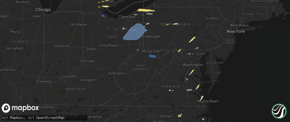
Hail
Wind
Tornado
0
Estimated number of impacted properties by a 1.00" hail or larger0
Estimated number of impacted properties by a 1.75" hail or larger0
Estimated number of impacted properties by a 2.50" hail or largerStorm reports in West Virginia
West Virginia
| Date | Description |
|---|---|
| 06/14/20265:00 PM CDT | Trees and power lines down on 3800 block of mountain lake road. |
| 06/14/20264:54 PM CDT | Tree down dur to thunderstorm winds at woods road. |
| 06/14/20264:50 PM CDT | Power lines down at johnson mill road due to thunderstorm winds. |
| 06/14/20264:34 PM CDT | Several trees reported down due to thunderstorm winds across the northeastern portion of the county. Time estimated via radar. |
| 06/14/20262:45 PM CDT | Tree in roadway in the 5000 block of russet rd. Time estimated from radar. |
| 06/14/20261:38 PM CDT | Thunderstorm winds blew down one tree along the 3500 block of leonard-cordova road. |
All States Impacted by Hail Map on June 14, 2026
Cities Impacted by Hail Map on June 14, 2026
- Ann Arbor, MI
- Ypsilanti, MI
- Dearborn, MI
- Detroit, MI
- Dundee, MI
- Milan, MI
- Maybee, MI
- Carleton, MI
- South Rockwood, MI
- Newport, MI
- Rockwood, MI
- Wayne, MI
- Westland, MI
- Walhalla, SC
- Tamassee, SC
- Salem, SC
- Six Mile, SC
- Sunset, SC
- Pickens, SC
- Canton, MI
- Inkster, MI
- Garden City, MI
- Galivants Ferry, SC
- Millbury, OH
- Curtice, OH
- Northwood, OH
- Genoa, OH
- Clay Center, OH
- Graytown, OH
- Martin, OH
- Woodville, OH
- Elmore, OH
- Jacksonville, NC
- Jesup, GA
- Maysville, NC
- Georgetown, SC
- Murrells Inlet, SC
- Myrtle Beach, SC
- Bucyrus, OH
- Van Horn, TX
- Bowersville, GA
- Canon, GA
- Geneva, OH
- Sedona, AZ
- Mansfield, OH
- Ashland, OH
- Holly Ridge, NC
- Ashtabula, OH
- Austinburg, OH
- Jefferson, OH
- Bainbridge, GA
- Climax, GA
- Belhaven, NC
- Aurora, NC
- Wooster, OH
- Whigham, GA
- Scranton, NC
- Blounts Creek, NC
- Montville, OH
- Chardon, OH
- Madison, OH
- Orrville, OH
- Sterling, OH
- Burbank, OH
- Smithville, OH
- Creswell, NC
- Windsor, OH
- Rome, OH
- Bath, NC
- Conneaut, OH
- Kingsville, OH
- Springboro, PA
- Albion, PA
- Pierpont, OH
- West Springfield, PA
- Live Oak, FL
- Columbia, NC
- Edinboro, PA
- Conneautville, PA
- Clinton, OH
- Pinetown, NC
- Willard, NC
- Burgaw, NC
- Andover, OH
- Dorset, OH
- Ringgold, PA
- Timblin, PA
- Punxsutawney, PA
- Goldsmith, TX
- Notrees, TX
- Clinton, NC
- Cambridge Springs, PA
- Venango, PA
- Linesville, PA
- Saegertown, PA
- Dillwyn, VA
- Melbourne, FL
- Anita, PA
- Reynoldsville, PA
- Meadville, PA
- Waterford, PA
- Conneaut Lake, PA
- Winslow, AZ
- Union City, PA
- Kenansville, FL
- Du Bois, PA
- Centerville, PA
- Williams, AZ
- Guys Mills, PA
- Sykesville, PA
- Spartansburg, PA
- Wagener, SC
- Enon Valley, PA
- New Castle, PA
- Bessemer, PA
- New Wilmington, PA
- Volant, PA
- Odessa, TX
- Mercer, PA
- Grove City, PA
- Clearfield, PA
- Claxton, GA
- Collins, GA
- Rio Rancho, NM
- Metter, GA
- Cobbtown, GA
- Rootstown, OH
- North Lima, OH
- Lake Milton, OH
- Newton Falls, OH
- Wilmot, OH
- Amsterdam, OH
- Wellsville, OH
- New Philadelphia, OH
- Beloit, OH
- Mineral City, OH
- Magnolia, OH
- Navarre, OH
- Alliance, OH
- Millersburg, OH
- Hanoverton, OH
- Waynesburg, OH
- Stone Creek, OH
- Baltic, OH
- Lowellville, OH
- Sebring, OH
- Newcomerstown, OH
- Bolivar, OH
- Canton, OH
- East Sparta, OH
- Beaver, PA
- Bloomingdale, OH
- Fresno, OH
- Negley, OH
- Somerdale, OH
- Stratton, OH
- Brewster, OH
- Salem, OH
- Strasburg, OH
- Minerva, OH
- Scio, OH
- Hopedale, OH
- Mechanicstown, OH
- Dover, OH
- East Liverpool, OH
- Louisville, OH
- Leetonia, OH
- East Springfield, OH
- West Lafayette, OH
- Kensington, OH
- Struthers, OH
- Gnadenhutten, OH
- Freeport, OH
- Salineville, OH
- Jewett, OH
- North Benton, OH
- Lisbon, OH
- Beach City, OH
- Homeworth, OH
- North Jackson, OH
- Tuscarawas, OH
- Sandyville, OH
- Youngstown, OH
- Hammondsville, OH
- Wampum, PA
- Dundee, OH
- East Rochester, OH
- Coshocton, OH
- New Manchester, WV
- Diamond, OH
- Warsaw, OH
- Beaver Falls, PA
- Damascus, OH
- East Canton, OH
- Washingtonville, OH
- Georgetown, PA
- Midland, PA
- Malvern, OH
- New Springfield, OH
- Bowerston, OH
- Deerfield, OH
- Massillon, OH
- Paris, OH
- Petersburg, OH
- Hartville, OH
- Cadiz, OH
- Leesville, OH
- Chester, WV
- Richmond, OH
- Limaville, OH
- Warren, OH
- Zoar, OH
- Robertsville, OH
- Uhrichsville, OH
- Berlin Center, OH
- Carrollton, OH
- Canfield, OH
- Irondale, OH
- Middlebranch, OH
- New Middletown, OH
- Dennison, OH
- Newell, WV
- New Cumberland, WV
- Sherrodsville, OH
- Summitville, OH
- Toronto, OH
- Sugarcreek, OH
- Dellroy, OH
- Empire, OH
- Bergholz, OH
- North Canton, OH
- Industry, PA
- East Palestine, OH
- New Galilee, PA
- Tippecanoe, OH
- New Waterford, OH
- Steubenville, OH
- Port Washington, OH
- New Brighton, PA
- Columbiana, OH
- Darlington, PA
- Rochester, PA
- Rogers, OH
- Atwater, OH
- Midvale, OH
- Appomattox, VA
- Frenchville, PA
- Farmville, VA
- Lorida, FL
- Buckingham, VA
- Gladstone, VA
- Clear Spring, MD
- Hedgesville, WV
- Big Pool, MD
- Partlow, VA
- Ambridge, PA
- Aliquippa, PA
- Greencastle, PA
- Mercersburg, PA
- Spotsylvania, VA
- Venus, FL
- Lake Placid, FL
- Ruther Glen, VA
- Woodford, VA
- Suffolk, VA
- Clarington, OH
- Woodsfield, OH
- Sardis, OH
- Las Cruces, NM
- Carrollton, VA
- Hampton, VA
- Yorktown, VA
- Newport News, VA
- Folkston, GA
- Tubac, AZ
- Nahunta, GA
- Henrico, VA
- Richmond, VA
- Carlisle, PA
- Mechanicsburg, PA
- Poquoson, VA
- Welcome, MD
- Nanjemoy, MD
- La Plata, MD
- Port Tobacco, MD
- Sandston, VA
- Nashville, NC
- West Point, VA
- Barhamsville, VA
- Battleboro, NC
- Rocky Mount, NC
- Harrisburg, PA
- Marysville, PA
- Dauphin, PA
- Enola, PA
- Duncannon, PA
- Pomfret, MD


