Hail Map in Colorado on June 22, 2026
The weather event in Colorado on June 22, 2026 includes Hail, Tornado, and Wind maps. 21 states and 419 cities were impacted and suffered possible damage. The total estimated number of properties impacted is 24,052.
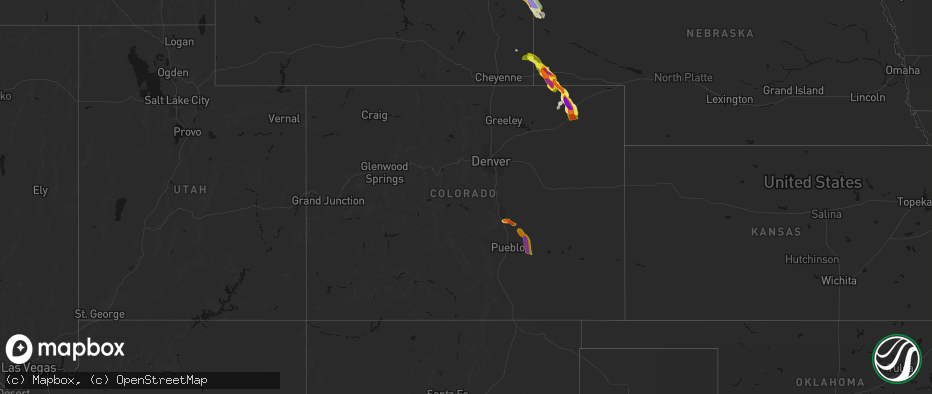
Hail
Tornado
Wind
24,052
Estimated number of impacted properties by a 1.00" hail or larger18,080
Estimated number of impacted properties by a 1.75" hail or larger9,106
Estimated number of impacted properties by a 2.50" hail or largerStorm reports in Colorado
Colorado
| Date | Description |
|---|---|
| 06/22/20266:51 PM CDT | A local report indicates 61 MPH wind near 3 E Union |
| 06/22/20266:43 PM CDT | A local report indicates 60 MPH wind near 1 ENE Hillrose |
| 06/22/20266:42 PM CDT | Corrects previous tornado report from 7 ssw fowler. Lasted 5:42 to 5:47 pm. |
| 06/22/20266:40 PM CDT | Power lines down. |
| 06/22/20266:39 PM CDT | A local report indicates 1.50 inch wind near 7 WNW Burdett |
| 06/22/20266:35 PM CDT | A local report indicates 1.50 inch wind near Fowler |
| 06/22/20266:32 PM CDT | Report from mping: hen egg |
| 06/22/20266:28 PM CDT | Report from mping: ping pong ball |
| 06/22/20266:22 PM CDT | A local report indicates a tornado near 1 W Fowler |
| 06/22/20266:12 PM CDT | A local report indicates 2.25 inch wind near 3 NNE Olney Springs |
| 06/22/20266:12 PM CDT | [landspout] |
| 06/22/20266:10 PM CDT | A local report indicates 65 MPH wind near 6 N Pueblo Depot |
| 06/22/20266:10 PM CDT | Report from mping: hen egg+ |
| 06/22/20266:08 PM CDT | A local report indicates 1.75 inch wind near 1 S Atwood |
| 06/22/20266:07 PM CDT | A local report indicates 2.50 inch wind near 1 S Sterling |
| 06/22/20266:05 PM CDT | Report from mping: hen egg |
| 06/22/20266:01 PM CDT | Drove through the hail core and made the measurement. |
| 06/22/20266:01 PM CDT | Report from mping: golf ball |
| 06/22/20266:00 PM CDT | A local report indicates 62 MPH wind near Atwood |
| 06/22/20265:58 PM CDT | A local report indicates 2.50 inch wind near 2 SSE Sterling |
| 06/22/20265:57 PM CDT | A local report indicates 60 MPH wind near 1 NNE Atwood |
| 06/22/20265:55 PM CDT | A local report indicates 3.00 inch wind near 4 W Sterling |
| 06/22/20265:49 PM CDT | A local report indicates 1.75 inch wind near 1 NE Sterling |
| 06/22/20265:45 PM CDT | A local report indicates 1.50 inch wind near 12 NE Pueblo Depot |
| 06/22/20265:45 PM CDT | A local report indicates 67 MPH wind near 4 NNW Pawnee Pass |
| 06/22/20265:29 PM CDT | A local report indicates 59 MPH wind near 2 ESE Sterling |
| 06/22/20265:23 PM CDT | A local report indicates 3.00 inch wind near 6 WSW North Sterling Re |
| 06/22/20265:08 PM CDT | Trained spotter reported 2 inch hail falling out of the storm core. |
| 06/22/20264:18 PM CDT | A local report indicates 1.50 inch wind near 2 N Fountain |
| 06/22/20264:15 PM CDT | A local report indicates 1.00 inch wind near 2 ENE Fountain |
| 06/22/20264:07 PM CDT | A local report indicates 1.00 inch wind near 2 N Fountain |
| 06/21/20269:58 PM CDT | At home weather station. |
| 06/21/20269:51 PM CDT | Twitter video of winds on i-70 in stratton; estimated 60 mph from blowing rain. |
| 06/21/20269:49 PM CDT | Mping. |
| 06/21/20269:45 PM CDT | A local report indicates 1.00 inch wind near Stratton |
| 06/21/20269:37 PM CDT | A local report indicates 1.50 inch wind near Stratton |
| 06/21/20269:36 PM CDT | Siding shredded on a home. |
| 06/21/20269:35 PM CDT | A local report indicates 1.00 inch wind near Stratton |
| 06/21/20269:32 PM CDT | A local report indicates 2.00 inch wind near 8 N Stratton |
| 06/21/20269:01 PM CDT | Twitter report with a hail stone estimated baseball sized; time estimated from radar. |
| 06/21/20269:00 PM CDT | Chaser estimated 70-80+ mph wind gusts. |
| 06/21/20268:59 PM CDT | Twitter report of multiple hail stones compared to 1 dollar bill; time estimated from radar. |
| 06/21/20268:54 PM CDT | Multiple 4 inch hail stones reported. |
| 06/21/20268:51 PM CDT | Golf ball sized hail. Quarters falling at 5 til. |
| 06/21/20268:45 PM CDT | Quarter sized hail reported by joes fire department. |
| 06/21/20268:37 PM CDT | A local report indicates 2.00 inch wind near 1 SSE Cope |
| 06/21/20268:27 PM CDT | Report from mping: hen egg |
| 06/21/20268:19 PM CDT | A local report indicates 3.50 inch wind near 6 N Cope |
| 06/21/20267:56 PM CDT | Large tree snapped and multiple limbs down. |
| 06/21/20267:30 PM CDT | Tree limbs down and street flooding. |
| 06/21/20267:30 PM CDT | Power lines down along us34 from akron to otis. |
| 06/21/20267:18 PM CDT | A local report indicates 95 MPH wind near 4 SE Akron |
| 06/21/20267:12 PM CDT | A local report indicates 109 MPH wind near 1 NNW Akron |
| 06/21/20267:10 PM CDT | A local report indicates 61 MPH wind near 1 ESE Akron |
| 06/21/20267:10 PM CDT | A local report indicates 92 MPH wind near 1 WNW Akron |
| 06/21/20267:04 PM CDT | A local report indicates 113 MPH wind near 1 W Akron |
| 06/21/20267:03 PM CDT | A local report indicates 80 MPH wind near 4 SE Akron |
| 06/21/20267:02 PM CDT | 4 inch tree limbs snapped. |
| 06/21/20267:01 PM CDT | A local report indicates 64 MPH wind near 4 E Union |
| 06/21/20267:01 PM CDT | A local report indicates 64 MPH wind near 3 E Union |
| 06/21/20267:00 PM CDT | A local report indicates 75 MPH wind near 4 W Platner |
All States Impacted by Hail Map on June 22, 2026
Cities Impacted by Hail Map on June 22, 2026
- Bighorn, MT
- Lagrange, WY
- Riverside, NJ
- Beverly, NJ
- Willingboro, NJ
- Riverton, NJ
- Burlington, NJ
- Bordentown, NJ
- Mount Holly, NJ
- Moorestown, NJ
- Palm City, FL
- Port Saint Lucie, FL
- Columbus, NJ
- Chesterfield, NJ
- Wrightstown, NJ
- Florence, NJ
- Allentown, NJ
- Trenton, NJ
- Buffalo, WY
- Palmyra, NJ
- Philadelphia, PA
- Cream Ridge, NJ
- Myakka City, FL
- Parrish, FL
- Newton, GA
- Jobstown, NJ
- Albin, WY
- Clearmont, WY
- Stanley, VA
- Shenandoah, VA
- Moultrie, GA
- Birney, MT
- Fort Stockton, TX
- Shawnee, WY
- Douglas, WY
- Bushnell, NE
- Kimball, NE
- Bowling Green, FL
- Ona, FL
- Lost Springs, WY
- Pine Bluffs, WY
- Harrisburg, NE
- Lusk, WY
- Decker, MT
- Marathon, TX
- Ardmore, AL
- Toney, AL
- Elkmont, AL
- Athens, AL
- Troy, AL
- Harrison, NE
- Gillette, WY
- Otter, MT
- Banks, AL
- Harvest, AL
- Manville, WY
- Huntsville, AL
- Meridianville, AL
- Ochopee, FL
- Manassas, VA
- Clifton, VA
- Fountain, CO
- Colorado Springs, CO
- Hazel Green, AL
- Nashville, GA
- Arcadia, FL
- Labelle, FL
- New Market, AL
- Louisville, AL
- Midway, AL
- Clayton, AL
- Arvada, WY
- Huntland, TN
- Burke, VA
- Fairfax Station, VA
- Fairfax, VA
- Lehigh Acres, FL
- Immokalee, FL
- Venus, FL
- Elora, TN
- Flintville, TN
- Gurley, AL
- Princeton, AL
- Estillfork, AL
- Scottsboro, AL
- Recluse, WY
- Dix, NE
- Padroni, CO
- Peetz, CO
- Wright, WY
- Moore Haven, FL
- Jackson, GA
- Griffin, GA
- Fackler, AL
- Stevenson, AL
- Sherwood, TN
- South Pittsburg, TN
- Hollywood, AL
- Bridgeport, AL
- Flat Rock, AL
- Glenmoore, PA
- Downingtown, PA
- Chester Springs, PA
- Clewiston, FL
- Devils Tower, WY
- Kaycee, WY
- Jay Em, WY
- Ider, AL
- Pisgah, AL
- Trenton, GA
- Rising Fawn, GA
- Jasper, TN
- Bryant, AL
- Guild, TN
- Higdon, AL
- Torrington, WY
- Fort Myers, FL
- Moorcroft, WY
- Pennsauken, NJ
- Centreville, VA
- Honey Brook, PA
- Elverson, PA
- Union Grove, NC
- Hamptonville, NC
- Wildwood, GA
- Crane, TX
- Sundance, WY
- Bridgeport, NJ
- Lodge Grass, MT
- Levittown, PA
- Fairless Hills, PA
- Morrisville, PA
- Langhorne, PA
- Swedesboro, NJ
- Gibbstown, NJ
- Ridley Park, PA
- Crum Lynne, PA
- Harmony, NC
- New Raymer, CO
- Sterling, CO
- Iliff, CO
- Chattanooga, TN
- Ooltewah, TN
- Rossville, GA
- Ringgold, GA
- Flintstone, GA
- Whiteside, TN
- Lookout Mountain, TN
- Lookout Mountain, GA
- Fort Oglethorpe, GA
- Chickamauga, GA
- Whitwell, TN
- Bristol, PA
- Mickleton, NJ
- Mullica Hill, NJ
- Clarksboro, NJ
- Winston Salem, NC
- Danbury, NC
- Boone, CO
- Lead, SD
- Deadwood, SD
- Sturgis, SD
- Wyola, MT
- McDonald, TN
- Cohutta, GA
- Harrison, TN
- Apison, TN
- Cleveland, TN
- Queenstown, MD
- Lake Wales, FL
- Sheridan, WY
- Nemo, SD
- Crandall, GA
- Dalton, GA
- Old Fort, TN
- Piedmont, SD
- Shady Side, MD
- Stevensville, MD
- Churchton, MD
- Easton, MD
- Claiborne, MD
- Wye Mills, MD
- Grasonville, MD
- Fleming, CO
- McCamey, TX
- Haines City, FL
- Lance Creek, WY
- Merino, CO
- Pemberton, NJ
- Browns Mills, NJ
- Midkiff, TX
- Midland, TX
- Saint Michaels, MD
- Atwood, CO
- Queen Anne, MD
- Cordova, MD
- Mcdaniel, MD
- Odessa, TX
- Frostproof, FL
- Williamstown, NJ
- Hammonton, NJ
- Sicklerville, NJ
- Glenburn, ND
- Deering, ND
- Reliance, TN
- Benton, TN
- Ocoee, TN
- Charleston, TN
- Cisco, GA
- Copperhill, TN
- Fowler, CO
- Akron, CO
- Otis, CO
- Mitchell, NE
- Kenansville, FL
- River Ranch, FL
- Black Hawk, SD
- Hillsboro, MD
- Denton, MD
- Wittman, MD
- Morrill, NE
- Ridgely, MD
- Scottsbluff, NE
- Rapid City, SD
- Snyder, CO
- Gering, NE
- Minatare, NE
- Bayard, NE
- Mcgrew, NE
- Melbeta, NE
- Olney Springs, CO
- Manzanola, CO
- Rocky Ford, CO
- Ordway, CO
- Kim, CO
- Box Elder, SD
- La Junta, CO
- Dalton, NE
- Bridgeport, NE
- Potter, NE
- Yuma, CO
- Broadwater, NE
- Gurley, NE
- Cope, CO
- Joes, CO
- Anton, CO
- Trinidad, CO
- Rozet, WY
- Upton, WY
- Williamsburg, VA
- Las Animas, CO
- Hayes, VA
- Gloucester, VA
- Lodgepole, NE
- Sidney, NE
- Newcastle, WY
- Seibert, CO
- Vona, CO
- Flagler, CO
- Yorktown, VA
- Newport News, VA
- Chunky, MS
- Enterprise, MS
- Kirk, CO
- Stratton, CO
- Seaford, VA
- Osage, WY
- Homer, LA
- Bethune, CO
- Stonewall, MS
- Custer, SD
- Hill City, SD
- Quitman, MS
- Downsville, LA
- Strong, AR
- Spearsville, LA
- Edgemont, SD
- Bastrop, LA
- Farmerville, LA
- Calhoun, LA
- Pringle, SD
- Burlington, CO
- Bonita, LA
- West Monroe, LA
- Fairburn, SD
- Buffalo Gap, SD
- Hot Springs, SD
- Crossett, AR
- Cheyenne Wells, CO
- Buffalo, SD
- Oral, SD
- Pine Ridge, SD
- Oglala, SD
- Manderson, SD
- Wounded Knee, SD
- Pattonville, TX
- Blossom, TX
- Deport, TX
- Batesland, SD
- Gordon, NE
- Rushville, NE
- El Dorado, AR
- Annona, TX
- Avery, TX
- Mayersville, MS
- Whitney, NE
- Rolling Fork, MS
- Yazoo City, MS
- Holly Bluff, MS
- Ruston, LA
- Louise, MS
- Fouke, AR
- Mangum, OK
- Clarksville, TX
- Allen, SD
- Lewisville, AR
- Ravenna, TX
- Choudrant, LA
- Magnolia, AR
- Ivanhoe, TX
- Hendrix, OK
- Bonham, TX
- Martin, SD
- Emerson, AR
- Detroit, TX
- Bernice, LA
- Wellington, TX
- Maud, TX
- Duke, OK
- Dubach, LA
- Eros, LA
- Arcadia, LA
- Simsboro, LA
- Garland City, AR
- Bogata, TX
- Childress, TX
- Bradley, AR
- Hope, AR
- Eldorado, OK
- Chatham, LA
- Chadron, NE
- Butler, AL
- Sweet Water, AL
- Haynesville, LA
- Stamps, AR
- Arapahoe, CO
- Plain Dealing, LA
- Doddridge, AR
- Buckner, AR
- Rodessa, LA
- Waldo, AR
- Okaton, SD
- White River, SD
- Weskan, KS
- Murdo, SD
- Douglassville, TX
- Ida, LA
- Benton, LA
- Atlanta, TX
- Sharon Springs, KS
- Tribune, KS
- Plains, KS
- Meade, KS
- Ideal, SD
- Bivins, TX
- Crawford, NE
- Leoti, KS
- Marsland, NE
- Minden, LA
- Doyline, LA
- Princeton, LA
- Haughton, LA
- Winner, SD
- Fowler, KS
- Marietta, TX
- Marienthal, KS
- Hay Springs, NE
- Burke, SD
- Laverne, OK
- Elm Grove, LA
- Balko, OK
- Deerfield, KS
- Follett, TX
- Alliance, NE
- Lakin, KS
- Paris, TX
- Gate, OK
- Forgan, OK
- Holcomb, KS
- Ellsworth, NE
- Garden City, KS
- New Boston, TX
- Hooks, TX
- Texarkana, TX
- Shattuck, OK
- Benkelman, NE
- Bingham, NE
- Lakeside, NE
- Wauneta, NE
- De Kalb, TX
- Enders, NE
- Imperial, NE
- Max, NE
- Sublette, KS
- Stratton, NE
- Hugo, OK
- Ashdown, AR
- Boswell, OK
- Ashby, NE
- Oshkosh, NE
- Ulysses, KS
- Gage, OK
- Satanta, KS
- Idabel, OK
- Hyannis, NE
- Palisade, NE
- Arnett, OK
- Oakley, KS
- Simms, TX


